


STUDY ON THE MECHANISM OF STAGNATING AND LESS-STEERED TYPHOON RUMBIA
-
摘要: 2018年1818号台风“温比亚”进入河南后停滞少动,移向有多次改变,累计在河南省境内滞留长达40小时,造成河南省东部历史罕见的极端暴雨天气。利用高空探测、地面观测、NCEP 1 °×1 °再分析等资料及中央气象台台风定位数据,对“温比亚”登陆进入河南境内后停滞少动及转向机理做详细诊断分析,结果显示:台风低压处在100 hPa高压带中的弱风区里,低层受高压带“包裹”或阻挡,低压缓行或停滞。200 hPa低压附近有风速辐合时,低压移速减慢,反之则加速,低压下游的风向对其移动方向有很好的指示意义。低压周围合成风场显示,北侧偏东风远大于南侧偏西风时,低压西行;东侧南风大于西侧北风时,低压北行;低压周围风场对称分布时,低压停滞;当非对称逐渐加强时,移向转为大风速轴的方向。500 hPa台风低压中心附近最大U、V风风速演变表明,北侧东风逐渐减小,西行低压移速随之变慢;东西风速差及南北风速差均减小到最小值且基本相当时,低压先停滞后转向,而后随着反方向风速的逐渐增大,低压沿着合动量方向移动。584 dagpm与588 dagpm之间风向与低压移动方向有很好的相关性。Abstract: After entering Henan province, the No.1818 typhoon Rumbia in 2018 stagnated and its movement direction changed many times. The accumulated stagnation time in Henan amounted to 40 hours and Rumbia caused rare and extreme rainstorms in eastern Henan. Using high altitude sounding and ground observation data, NCEP 1°×1° reanalysis data and typhoon positioning data of the Central Meteorological Observatory, the paper made a detailed diagnosis and analysis about the physical mechanism of stagnating and less-steered Rumbia. The results showed that the typhoon-turned low pressure was in the weak wind zone of the 100 hPa high pressure zone and the low layer was wrapped or blocked by the high-pressure zone. The low pressure was slow and stagnant. When there was wind speed convergence near the low pressure of 200 hPa, the low pressure would slow down, and otherwise it would accelerate. The wind direction downstream of the low pressure had a good indication of its moving direction. The synthetic wind field around the low pressure showed that when the east wind on the north was much larger than the west wind on the south, the low pressure moved westward; the south wind on the east was much larger than the north wind on the west, and the low pressure moved northward. When the low-pressure surrounding wind field was symmetrically distributed, the low pressure stagnated. When the asymmetry was gradually strengthened, it moved to the direction of the large wind speed axis. The maximum U and V wind speed changes near the 500hPa typhoon low-pressure center indicated that as the east wind of the north gradually decreased, the westbound low pressure velocity decreased with it; when the east-west wind speed difference and the north-south wind speed difference near the low pressure decreased to the minimum and basic equivalence, the low pressure stopped and lagged, and then with the gradual increase of the wind speed in the opposite direction, the low pressure moved along the direction of the combined movement. The wind direction between 584 dagpm and 588 dagpm correlated well with the direction of low-pressure movement.
-
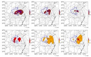
图 5 850 hPa与500 hPa平均风场(矢量)及台风中心(

a. 18日02时;b. 18日08时;c. 18日14时;d. 18日20时;e. 19日02时;f. 19日08时。
表 1 台风低压中心位置及风力/(m/s)
时间 经度/°E 纬度/°N 风力/(m/s) 2018081814 114.6 32.7 16 2018081817 114.5 32.8 16 2018081820 114.4 32.9 16 2018081823 114.4 32.9 16 2018081902 114.4 33.0 16 2018081905 114.4 33.0 16 2018081908 114.7 33.3 16 2018081911 115.0 33.5 16  下载: 导出CSV
-
[1] 许映龙, 张玲, 高栓柱.我国台风预报业务的现状及思考[J].气象, 2010, 36(7): 43-46. [2] 段晶晶, 吴立广, 倪钟萍. 2004年台风"艾利"与"米雷"路径异常变化分析[J].气象学报, 2014, 72(1): 1-11. [3] 张娇艳, 吴立广, 张强.全球变暖背景下我国热带气旋灾害趋势分析[J].热带气象学报, 2011, 27(4): 442-454. [4] 吴影, 陈佩燕, 雷小途.登陆热带气旋路径和强度预报的效益评估初步研究[J].热带气象学报, 2017, 33(5): 675-682. [5] 许映龙, 张玲.我国台风预报业务的现状及思考[J].气象, 2010, 36(7): 43-49. [6] 麻素红, 吴俞, 瞿安祥, 等. T213与T639模式热带气旋预报误差对比[J].应用气象学报, 2012, 23(2): 167-173. [7] 李辑, 李菲, 林蓉, 等.东亚盛夏北上转向台风年代际变化及与PDO的关系[J].热带气象学报, 2011, 27(5): 731-737. [8] 周昊, 朱伟军, 彭世球.不同微物理方案和边界层方案对超强台风"鲇鱼"路径和强度模拟的影响分析[J].热带气象学报, 2013, 28(5): 803-812. [9] 林志强, 边巴扎西, 文胜军, 等.孟加拉湾热带风暴活动路径的客观分类[J].热带气象学报, 2013, 29(6): 973-983. [10] 陈华, 王凯.台风与中纬度槽的相互作用对其转向之后的路径的影响[J].热带气象学报, 2015, 31(2): 145-152. [11] 郭兴亮, 钟玮.谱逼近方法对台风Megi(2010)路径模拟的改进及影响分析[J].热带气象学报, 2018, 34(4): 514-523. [12] 许娈, 崔晓鹏, 高守亭, 等.台风"鲇鱼"(1013)路径突变过程的成因分析[J].大气科学学报, 2015, 38(5): 658-669. [13] 徐亚钦, 翟国庆, 李国平, 等. WRF模式对高影响浙江型台风微物理和边界层参数化方案的优化试验[J].热带气象学报, 2017, 33(2): 201-211. [14] 张进, 麻素红, 陈德辉, 等. GRAPES_TYM改进及其在2013年西北太平洋和南海台风预报的表现[J].热带气象学报, 2017, 33(1): 64-73. [15] 陈耀登, 夏雪, 闵锦忠, 等.背景误差协方差变量平衡特征及其对台风同化和预报的影响[J].热带气象学报, 2017, 33(3): 289-298. [16] 王晓峰, 许晓林, 杨续超, 等.数值模式对强台风"菲特"登陆期间预报能力评述[J].大气科学学报, 2017, 40(5): 609-618. [17] 王海龙, 吴新桥, 黄增浩, 等.超强台风"威马逊"登陆期间近地层风速变化特征分析[J].热带气象学报, 2018, 34(3): 297-304. [18] 王咏青, 蔡敏敏, 张秀年.台风"珍珠"(2006)螺旋雨带发展机制的数值模拟研究[J].大气科学学报, 2018, 41(6): 786-796. [19] 倪钟萍, 吴立广, 张玲. 2005~2010年台风突变路径的预报误差及其环流背景[J].气象, 2013, 39(6): 719-727. [20] 钱传海, 端义宏, 麻素红, 等.我国台风业务现状及其关键技术[J].气象科技进展, 2012, 2(5): 36-43. [21] 朱乾根, 林锦瑞, 寿绍文[M].北京: 气象出版社, 2007, 526-530. [22] 仲荣根, 张旭, 刘梅.台风的结构变化与台风移动的关系[J].海洋学报(中文版), 1993, 15(5): 46-49. [23] 张玲, 许映龙, 黄奕武. 1330号台风海燕强烈发展和快速移动原因分析[J].气象, 2014, 40(12): 1 464-1 480. [24] 毕鑫鑫, 陈光华, 周伟灿.超强台风"天鹅"(2015)路径突变过程机理研究[J].大气科学, 2018, 42(1): 227-238. [25] 张行才, 王建新.强增温区及其形态变化对台风转向的指示作用[J].自然灾害学报, 2007, 16(4): 77-81. [26] 杨诚, 于文革.一种北上台风路径预报方法[J].气象, 2006, 32(8): 88-91. [27] 杨琼琼, 吴立广.中国24h台风路径预报难点及其大尺度环流分析[J].气象科学, 2015, 35(4): 389-397. [28] 陈联寿, 徐祥德, 解以扬, 等.台风异常运动及其外区热力不稳定非对称结构的影响效应[J].大气科学, 1997, 21(1): 84-91. [29] 黄先伦, 郭圳勉, 殷宏南, 等.超强台风"尤特"近海北翘的原因分析[J].广东气象, 2016, 38(6): 1-5. [30] 王新敏, 赵培娟, 李保生, 等.影响河南的台风登陆台风分析[J].河南气象, 2002, 25(2): 14-15. [31] 仰国光.台风环流非对称结构理论在TC9012异常路径预报中的应用[C].全国热带气旋讨论会论文集.北京: 气象出版社, 2001: 134-137. -


 点击查看大图

图(6) / 表(1)
计量
- 文章访问数: 355
- HTML全文浏览量: 58
- PDF下载量: 59
- 被引次数: 0
 粤公网安备 4401069904700003号