


THE IMPACT OF HIGH RESOLUTION TERRAIN ON THE PREDICTION OF GROUND ELEMENTS FROM GRAPES MODEL IN SOUTH CHINA
-
摘要: 华南区域GRAPES模式动力框架的更新使得高分辨地形数据能够进入模式。引入SRTM数据实现静态数据更新,结合模式内置数据,进行了批量模拟试验;通过站点检验方式,对批量试验结果进行对比,得出以下结论:对比业务使用的Topo10 m地形、Topo30 s地形、SRTM地形和基于SRTM多种插值方案得到的地形,海拔偏差的空间分布和分位数统计都有明显的改善,复杂地形区域的改善效果更显著。通过地面要素平均绝对误差(MAE)箱须图统计和模式西部站点绝对误差(AE)时间序列图对比分析,发现高分辨地形试验的2 m气温和10 m风速MAE和AE有大幅度的改善。高分辨地形对模式静态数据的改善是2 m气温和10 m风速MAE下降的主要原因,地形复杂区域对MAE改善的贡献高于模式其他区域。高分辨地形进入模式后会引起动力过程计算的虚假扰动,适当的滤波平滑能够抑制扰动,从而进一步提高预报精度。Abstract: The updating of the GRAPES model dynamics framework in south China enabled the model to include high-resolution terrain data. The Shuttle Radar Topography Mission (SRTM) data was introduced to update the static data of the model, and combined with the built-in terrain data of the model, a batch simulation experiment was carried out. The batch test was compared by using the station verification method. The results are shown as follows. Topo30 s terrain data, SRTM terrain, and terrain derived from various SRTM-based interpolation schemes, compared to the Topo10 m terrain currently used in the comparison mode, improve significantly in both the spatial distribution of altitude deviation and quartile statistics, especially so in complex terrain areas. The statistics of the boxplot of Mean Absolute Error (MAE) and the comparison of the Absolute Error (AE) time series of stations in the west of the model show that the MAE and AE of 2 m temperature and 10m wind speed of the high-resolution terrain experiments are greatly improved. The improvement of static data with high-resolution terrain is the main reason for the decrease of MAE in 2 m temperature and 10 m wind speed. Complex terrain contributes more to MAE improvement than other areas of the model. When the high-resolution terrain is introduced to the model, it causes the fictitious disturbance of the dynamic process calculation, and proper filtering suppresses it and further improves the prediction accuracy.
-
Key words:
- GRAPES /
- high resolution terrain /
- SRTM /
- interpolation method /
- boxplot /
- spatial distribution of MAE
-

图 2 模式地形高度减实况站点海拔偏差空间分布和绝对海拔偏差箱须图 单位:m。
a. Topo10 m; b. Topo30 s; c. SRTM3 s; d.各试验绝对海拔偏差箱须图。
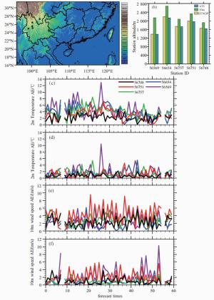
图 4 个例2 m气温和10 m风速模拟结果对比
a.个例站点选取,横坐标为经度,纵坐标为纬度,填色为海拔高度,▲为选取站点空间分布; b.个例站点海拔对比,横坐标为站号,纵坐标为站点海拔高度,单位:m; c. Control试验24 h预报时效站点2 m气温AE时间序列,横坐标为预报次数,单位:次,纵坐标为温度,单位:℃,2个时次的观测数据缺失,导致线条出现断点; d.同c,但为w16试验; e. Control试验24 h预报时效站点10 m风速AE时间序列,纵坐标为风速,单位:m/s; f.同e,但为w16试验。

图 5 Control试验同w16试验2 m气温和10 m风速MAE空间分布对比
a. Control试验模式24 h预报时效2 m气温MAE空间分布; b.同a,但试验为w16; c. Control试验模式24 h预报时效10 m风速MAE空间分布; d.同c,但试验为w16。

图 6 Control试验和w16试验2017060300个例10 m风速和风向结果对比
a.模式范围24 h预报场Control试验与站点实况10 m风速绝对偏差减去w16试验的空间分布,矩形框为偏差较大区,也是风向偏差重点分析区域,单位:m/s; b.重点分析区域SYNOP资料的16向wind rose(风向玫瑰图),填色表示风速,风矢端数值为该风向的平均风速; c. Control试验24 h预报时效重点分析区域16向wind rose; d.同c,但为w16试验。
表 1 试验设计表
试验名称 地形数据 试验名称 地形数据 Control Topo10 m w16 SRTM3s w16 30 s Topo30 s w4 SRTM3s w4 3 s SRTM3s  下载: 导出CSV
-
[1] 高学杰, 徐影, 赵宗慈, 等.数值模式不同分辨率和地形对东亚降水模拟影响的试验[J].大气科学, 2006, 30(2): 185-192. [2] 刘一, 陈德辉, 胡江林, 等. GRAPES中尺度模式地形有效尺度影响的理想数值试验研究[J].热带气象学报, 2011, 27(1): 53-62. [3] 李超.高分辨率GRAPES模式垂直坐标的改进试验研究[D].北京: 中国气象科学研究院, 2015. [4] GAL-CHEN T, SOMERVILLE R C J. On the use of a coordinate transformation for the solution of the Navier-Stokes equations[J]. Journal of Computational Physics, 1975, 17(2): 209-228. [5] 陈子通, 戴光丰, 罗秋红, 等.模式动力过程与物理过程耦合及其对台风预报的影响研究[J].热带气象学报, 2016, 32(1): 1-8. [6] 陈子通, 戴光丰, 钟水新, 等.中国南海台风模式(TRAMS-v2.0)技术特点及其预报性能[J].热带气象学报, 2016, 32(6): 831-840. [7] 苏勇, 沈学顺, 陈子通, 等. GRAPES_GFS中三维参考大气的研究:理论设计和理想试验[J].气象学报, 2018, 76(2): 241-254. [8] 朱文达, 张媛, 杨静, 等. 2015年华南区域模式贵州区域2 m气温预报偏差分析[J].中低纬山地气象, 2018, 42(2): 28-35, 84. [9] WEN X, DONG W, YUAN W, et al. Establishment and analysis of a High-Resolution Assimilation Dataset of the water-energy cycle in China[J]. Physics & Chemistry of the Earth, 2015, 87-88:126-141. [10] HE J J, YU Y, YU L J, et al. Impacts of uncertainty in land surface information on simulated surface temperature and precipitation over China[J]. Int J Climatol, 2017, 37(S1): 829-847. [11] MEIJ A D, VINUESA J F. Impact of SRTM and Corine Land Cover data on meteorological parameters using WRF[J]. Atmos Res, 2014, 143: 351-370. [12] MEIJ A D, BOSSIOLI E, PENARD C, et al. The effect of SRTM and Corine Land Cover data on calculated gas and PM10 concentrations in WRF-Chem[J]. Atmos Env, 2015, 101: 177-193. [13] KIRTHIGA S M, PATEL N R. Impact of updating land surface data on micrometeorological weather simulations from the WRF model[J]. Atmósfera, 2018, 31(2): 165-183. [14] NUNALEE C G, HORVÁTHÁ, BASU S. High-resolution numerical modeling of mesoscale island wakes and sensitivity to static topographic relief data[J]. Geoscientific Model Development, 2015, 8(8): 2 645-2 653. [15] 屠妮妮, 陈静, 何光碧.切比雪夫多项式在模式地形平滑中的应用研究[J].高原气象, 2012, 31(1): 47-56. [16] 何光碧, 彭俊, 屠妮妮.基于高分辨率地形数据的模式地形构造与数值试验[J].高原气象, 2015, 34(4): 910-922. [17] 王光辉, 陈峰峰, 沈学顺, 等.数值模式中地形滤波处理及水平扩散对降雨预报的影响[J].地球物理学报, 2008, 51(6): 1 642-1 650. [18] ROEBBER P J. Visualizing multiple measures of forecast quality[J]. Wea Forecasting, 2009, 24(2): 601-608. [19] BAMLER R. The SRTM Mission: A World-Wide 30 m resolution DEM from SAR Interferometry in 11 Days[C]//47. photogrammetrische woche, university stuttgart, 20.9-24.9DLR, 1999. [20] SHOWSTACK R. Digital elevation maps produce sharper image of Earth's topography[J]. Eos Transactions American Geophysical Union, 2003, 84(37): 363-363. [21] REUTER H I, NELSON A, JARVIS A. An evaluation of void-filling interpolation methods for SRTM data[J]. International Journal of Geographical Information Science, 2007, 21(9): 983-1 008. [22] HIRT C, FILMER M S, FEATHERSTONE W E. Comparison and validation of the recent freely available ASTER-GDEM ver1, SRTM ver4.1 and GEODATA DEM-9S ver3 digital elevation models over Australia[J]. Journal of the Geological Society of Australia, 2010, 57(3): 337-347. [23] MOURATIDIS A, BRIOLE P, KATSAMBALOS K. SRTM 3″ DEM (versions 1, 2, 3, 4) validation by means of extensive kinematic GPS measurements: a case study from North Greece[J]. International Journal of Remote Sensing, 2010, 31(23): 6 205-6 222. [24] RODRíGUEZ E, MORRIS C S, BELZ J E. A global assessment of the SRTM performance[J]. Photogrammetric Engineering & Remote Sensing, 2006, 72(3): 249-260. [25] 陈锋, 董美莹, 冀春晓.综合分析法在复杂地形气温精细格点化中的应用[J].高原气象, 2016, 35(5): 376-388. [26] 张小培, 银燕.复杂地形地区WRF模式四种边界层参数化方案的评估[J].大气科学学报, 2013, 36(1): 68-76. [27] 王曙东, 裴翀, 郭志梅, 等.基于SRTM数据的中国新一代天气雷达覆盖和地形遮挡评估[J].气候与环境研究, 2011, 16(4): 459-468. [28] 陈俊勇.对SRTM3和GTOPO30地形数据质量的评估[J].武汉大学学报(信息科学版), 2005, 30(11): 941-944. [29] WANG, W, BRUYÈRE C, DUDA M, et al. ARW version 4 modeling system user's guide[M]. Mesoscale & Miscroscale Meteorology Laboratory, National Center for Atmospheric Research, 2018, http://www2.mmm.ucar.edu/wrf/users/docs/user_guide_V4/WRFUsersGuide.pdf: 61-64 [30] 杨雨轩, 张立凤, 张斌, 等.四维集合变分同化方法在华南冬季暴雨模拟中的应用[J].热带气象学报, 2018, 34(2):217-227. [31] 赵杨洁, 李江南, 董雪晗, 等.模式分辨率对台风"天鸽"(2017)模拟效果的影响[J].热带气象学报, 2019, 35(5):629-643. [32] 麻素红, 陈德辉.国家气象中心区域台风模式预报性能分析[J].热带气象学报, 2018, 34(4):451-459. [33] 陈耀登, 陈海琴, 孙娟珍, 等.雷达观测对应模式变量非线性特征及对四维变分同化的影响[J].热带气象学报, 2018, 34(6):721-732. [34] 杨贵名, 宗志平, 马学款. "方框-端须图"及其应用示例[J].气象, 2005, 31(3): 53-55. [35] 高晓梅, 俞小鼎, 王令军, 等.鲁中地区分类强对流天气环境参量特征分析[J].气象学报, 2018, 76(2): 196-212. [36] 吴乃庚, 曾沁, 刘段灵, 等.日极端气温的主客观预报能力评估及多模式集成网格释用[J].气象, 2017, 43(5): 581-590. [37] 佟华, 姚明明, 王雨, 等. T213L31全球中期数值天气预报系统2m温度预报误差源分析[J].气象, 2006, 32(2): 52-57. [38] 康岚, 冯汉中, 屠妮妮, 等. Grapes模式预报西南地区夏季2m温度的检验评估[J].高原山地气象研究, 2009, 29(2): 26-32. [39] 陈超君, 王东海, 李国平, 等.冬季高海拔复杂地形下GRAPES-Meso要素预报的检验评估[J].气象, 2012, 38(6): 657-668. [40] CRUTCHER H L. On the standard vector-deviation wind rose[J]. J Atmos Sci, 1957, 14(1): 28-33. [41] 石岚, 徐丽娜, 郝玉珠.基于风速高相关分区的风电场风速预报订正[J].应用气象学报, 2016, 27(4): 506-512. [42] 靳军莉, 马建中, 林伟立, 等.华北平原固城站NO2对流层柱浓度变化特征[J].应用气象学报, 2016, 27(3): 303-311. [43] 王咏薇, 高山, 高卓, 等.一种基于精细边界层模式的复杂地形风电场风速预测方法: 中国, 201210479940.4[P]. 2012-11-23. -


 点击查看大图

计量
- 文章访问数: 445
- HTML全文浏览量: 67
- PDF下载量: 49
- 被引次数: 0
 粤公网安备 4401069904700003号