


THE ANALYSIS OF AN UNUSUALLY HEAVY RAIN INDUCED BY THE OUTER RAINBAND OF TYPHOON SOUDELOR IN FUZHOU
-
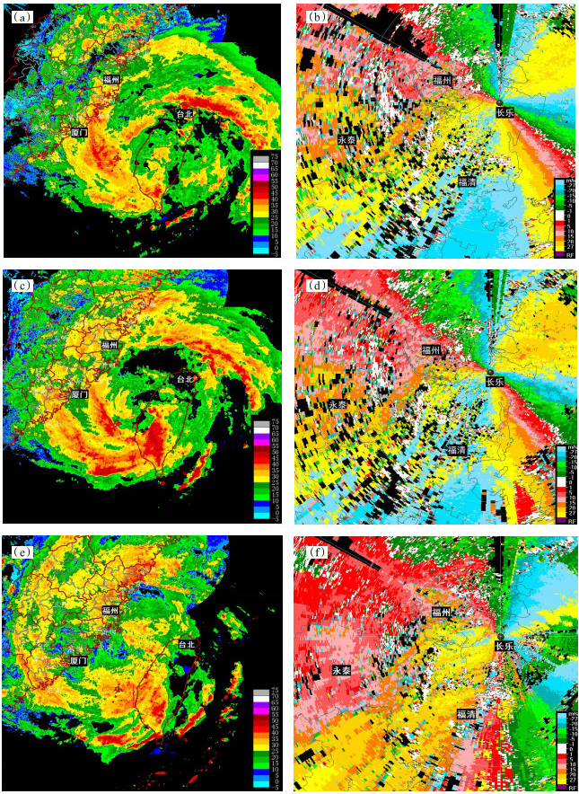
摘要: 受2015年第13号台风“苏迪罗”影响,福州出现特大暴雨。为研究台风登陆前局地强降水与地形的关系,针对福建长乐雷达的0 °仰角数据进行了风场反演,得到福州低空风场在强降雨发生时的结构及演变特征,综合利用NCEP 1 °×1 °再分析资料及福州三维地形数据,探索了福州地区持续性短时强降水的发生原因。结果表明:(1) “苏迪罗”影响期间正值南海季风爆发期,为台风提供了充沛的水汽;(2)强降雨发生时,福州地区存在正涡柱,配合强烈上升运动,为短时强降水的发生提供良好的动力条件;(3)雷达风场反演显示:当福州环境风场为东北气流,有一持久、稳定的分流区出现在福清北部,随着台风靠近,环境风逐渐由东北转为偏东风,分流区的位置也一直向内陆延伸,分流气流与台风环境气流形成了明显的辐合带,激发了螺旋雨带内中尺度对流云团的发生发展,造成短时强降水;(4)台风环境气流进入福州后出现的分流现象与福州的盆地地形有关。Abstract: In August 2015, subject to the impact of Typhoon 'Soudelor', Fuzhou suffered an unusually heavy rain. To study the relationship between the heavy rainfall and the terrain, radar-based low-level wind retrieval was analyzed to determine the structure of low-level wind field and the features of its evolution. The NCEP reanalysis data and 3D Fuzhou terrain were used to explore the causes of short-term rainfall in Fuzhou. What the study reveals is shown as follows: (1) A South China Sea summer monsoon provided abundant water vapor for the heavy rainfall. (2) There existed positive vortex in Fuzhou during the heavy rain, which provided favorable condition, coupled with intensive vertical motion. (3) Radar-based low-level wind retrieval showed that there existed a stable air flow at the north of Fuqing area when the wind field was northeasterly. As the typhoon approached, the wind field switched from northeast to east. A convergence zone was generated by a stable extended inland air flow and the typhoon wind field, which stimulated the development of meso-scale convective clouds in a spiral rain band. (4) The wind field of the typhoon was associated with the terrain of Fuzhou.
-
Key words:
- synoptics /
- typhoon rainstorm /
- Doppler weather radar /
- low-level wind retrieval
-

图 4 a. 6日20时—8日14时500 hPa平均场;b. 8日14时—10日20时500 hPa平均场;c. 8月6—10日候平均850 hPa水汽输送图;d.8月7日00时—9日12时福州上空水汽通量散度垂直剖面图(UTC)(单位:10-7 g/(hPa·cm2·s));e. 8月7日00时—9日12时福州上空风场与垂直速度垂直剖面图(UTC)(垂直速度单位:Pa/s);f.8月7日00时—9日12时福州上空涡度垂直剖面图(UTC)(单位:10-5·s-2)
-
[1] 林小红, 任福民, 刘爱鸣, 等.近46年影响福建的台风降水的气候特征分析[J].热带气象学报, 2008, 24(4): 411-416. [2] 陈联寿, 孟智勇.我国热带气旋研究十年进展[J].大气科学, 2001, 25(3): 420-432. [3] 李江南, 龚志鹏, 王安宇, 等.近十年来台风暴雨研究的若干进展与讨论[J].热带地理, 2004, 24(2): 113-117. [4] 胡姝, 孙立尹, 李英.热带气旋结构和强度变化研究进展[J].气象与环境学报, 2014, 30(4): 91-98. [5] 赵海坤, 吴立广.西北太平洋热带气旋气候变化的若干研究进展[J].气象科学, 2015, 35(1): 108-118. [6] 廖菲, 邓华, 赵中阔, 等.热带气旋科学观测试验及研究进展概况[J].热带气象学报, 2013, 29(4): 687-697. [7] 钮学新, 杜惠良, 刘建勇. 0216号台风降水及其影响降水机制的数值模拟试验[J].气象学报, 2005, 63(1): 57-68. [8] 沈杭锋, 高天赤, 周春雨, 等.台风海葵引发浙西山区大暴雨的成因[J].气象, 2014, 40(6): 733-743. [9] 董美莹, 陈联寿, 郑沛群, 等.登陆热带气旋暴雨突然增幅和特大暴雨之研究进展[J].热带气象学报, 2009, 25(4): 495-502. [10] PARRISH J R, BURPEE R W, MARKS J F D, et al. Rainfall patterns observed by digitized radar during landfall of Hurricane Frederic(1979)[J]. Mon Wea Rev, 1982, 110(12): 1 933-1 944. [11] 魏应植, 吴陈锋, 林长城, 等.冷空气侵入台风"珍珠"的多普勒雷达回波特征[J].热带气象学报, 2008, 24(6): 599-608. [12] 余贞寿, 周功铤, 赵放, 等.雷达资料对0414号台风"云娜"数值预报的改进[J].热带气象学报, 2008, 24(1): 59-66. [13] LEE W C, JOU B J D, CHANG P L, et al. Tropical cyclone kinematic structure retrieved from single-Doppler radar observations. Part Ⅲ: Evolution and structures of typhoon Alex (1987)[J]. Mon Wea Rev, 2000, 128(12): 3 982-4 001. [14] 陶祖钰.从单Doppler速度场反演风矢量场的VAP方法[J].气象学报, 1992, 50(1): 81-90. [15] 闵锦忠, 周振波, 彭霞云, 等.扩展VAP对单多普勒雷达径向风的反演及质量控制[J].南京大学学报(自然科学版), 2005, 41(6): 590-602. [16] 罗昌荣, 孙照渤, 魏鸣, 等.单多普勒雷达反演热带气旋近中心风场的VAP扩展应用方法[J].气象学报, 2011, 69(1): 170-180. -

 下载:
下载:


 点击查看大图

图(8)
计量
- 文章访问数: 907
- HTML全文浏览量: 69
- PDF下载量: 426
- 被引次数: 0
 粤公网安备 4401069904700003号