


APPLICATION OF AUTOMATIC METEOROLOGICAL STATION DATA IN THE SIMULATION OF A SQUALL LINE IN NORTH JIANGSU PROVINCE
-
摘要: 为了研究自动气象站资料在模拟中国东部飑线过程中的影响,利用WRF模式模拟了2009年6月14日发生在苏北地区的一次飑线过程。首先设计了两个数值试验,两个试验都只用FNL资料作为初始场和边界条件,但是模拟开始时间分别为北京时间10时和08时,离观测的飑线过程开始时间分别有3 h和5 h。在10时开始的试验(控制试验)中,模拟飑线过程时间上有3~4 h延迟,空间上向东偏移了100 km左右,但是试验可模拟出与观测相似的飑线发展过程,即对流从山东省南部开始、飑线弓形回波在江苏北部成熟和在江苏南部消亡的过程。而在08时开始的试验中(对比试验),没有能够模拟出与观测相似飑线发展过程,降水范围和飑线水平尺度偏小,对流强度明显偏弱,时间上比控制试验更晚。分析发现,FNL资料中的相对湿度低于观测,通过增加低层水汽,可提高模拟效果,对流触发时间也与观测更加接近。在加入地面自动气象站资料的敏感性实验中,对流触发时间比控制试验提前1 h,可模拟出与观测相似的飑线发展过程。因此,低层水汽对这次飑线过程模拟具有重要影响,在飑线数值模拟中加入地面自动气象站加密观测资料可有效提高模拟能力。Abstract: In order to study the effect of automatic meteorological station data on the simulation of squall lines in eastern China, a squall line occurred in northern Jiangsu Province on 14, 2009 was simulated by WRF model. First, two experiments were designed. Both experiments only used FNL data as the initial field and boundary conditions, but the start time of the simulations were 1000 and 0800 Beijing Standard Time (BST), respectively. The simulated squall line that started at 1000 BST in control run (CTL) was delayed for 3-4 hours and shifted to the east about 100 km, but the results captured the features of the squall line evolution, structure and precipitation that are similar to the observation. However, the experiment started at 0800 BST (EXP-C) was not able to simulate the development of the squall line. The precipitation range and the squall line horizontal scale were small, the convection intensity was obviously weak, and the triggering time was later than the CTL. It is found that the relative humidity in the FNL data is lower than the observation. By increasing the low-level water vapor, the simulation results can be improved, especially the triggering time of convection is closer to the observation. In the sensitivity experiment of adding automatic meteorological station data (EXP-S), the convection triggering time is 1h ahead of the CTL. Therefore, the low-level water vapor has an important influence on the squall line simulation. Adding the automatic meteorological station data to the squall line numerical simulation can effectively improve the results.
-

图 1 a.南京雷达站点所观测到的13、15、17和22时雷达回波(阴影)和受此次飑线过程影响的主要城市名称、位置;b.控制试验中模拟的3 km高度上17、19、21、23时和01时时刻雷达回波(阴影)和1 km高度上1 m/s的上升运动(等值线)。
本次研究中的数值模拟区域,分别用D01、D02和D03标出。

图 2 a.各站点观测的此次飑线过程1400—2200 BST的累积降水(单位:mm);b. a中怀远、蚌埠、滁州和镇江四个站点(方块)的10 min降水(柱状,单位:mm)和2 min平均风速(折线,单位:m/s),各站点颜色和柱状图、折线图的颜色相对应。
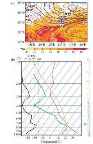
图 3 a. 2009年6月14日14时FNL再分析资料显示的500 hPa位势高度(等值线,单位:m),风场(矢干,单位:m/s)和大气水汽含量大于24 kg/m2的分布(阴影,单位:kg/m2);b. 2009年6月14日14时对流发生位置的T-lnP图以及不同高度上的风场。

图 7 沿图 6黑线的飑线垂直结构
a.阴影为雷达回波(单位:dBz),等值线为垂直运动(单位:m/s),流线为风场;b.阴影为扰动气压(单位:hPa),流线为风场,绿色等值线为降水率(单位:g/kg),黑色虚线为温度扰动场(单位:℃)。

图 9 a. EXP-C中的CAPE(单位:J/kg)减去CTL中CAPE的差值(阴影);b. EXP-C中0~3 km垂直风切变(单位:m/s)减去CTL中垂直切变的差值(阴影和矢量);c. EXP-C中在对流触发地区(a中的方框)区域平均的比湿(等值线,单位:g/kg)与温度(阴影,单位:℃)减去CTL中的差值随时间的变化。

图 10 将CTL中的比湿(a)和温度(b)分别替换EXP-C中的气象参数之后的CAPE值与原来的差值(单位:J/kg);c.对流触发区域中观测站的相对湿度平均值(黑线,单位:%),各站点相对湿度变化范围(阴影,单位:%)随时间变化以及EXP-C中的相对湿度变化(红线,单位:%)。
-
[1] FUJITA T T, WAKIMOTO R M. Five scales of airflow associated with a series of downbursts on 16 July 1980[J]. Mon Wea Rev, 1981, 109(7): 1 438-1 456. [2] JOHNS R H, HIRT W D. Derechos: Widespread convectively induced windstorms[J]. Wea Forecasting, 1987, 2(1): 32-49. [3] PRZYBYLINSKI R W. The bow echo: Observations, numerical simulations, and severe weather detection methods[J]. Wea Forecasting, 1995, 10(2): 203-218. [4] ATKINS N T, ARNOTT J M, PRZYBYLINSKI R W, et al. Vortex structure and evolution within bow echoes. Part Ⅰ: Single-Doppler and damage analysis of the 29 June 1998 derecho[J]. Mon Wea Rev, 2004, 132(9): 2 224-2 242. [5] GLICKMAN T S. Glossary of Meteorology[M]. Amer Meteor Soc, 2000: 855. [6] 方翀, 林隐静, 曹艳察, 等.华南地区西风带飑线和台风飑线环境场特征统计对比分析[J].热带气象学报, 2017, 33(6): 965-974. [7] MENG Z, YAN D, ZHANG Y. General features of squall lines in East China[J]. Mon Wea Rev, 2013, 141(5): 1 629-1 647. [8] 侯淑梅, 闵锦忠, 刁秀广, 等.飑线发展过程中回波合并的特征分析[J].大气科学学报, 2018, 41(3): 367-376. [9] 蓝渝, 张涛, 郑永光, 等.国家级中尺度天气分析业务技术进展亚:对流天气中尺度过程分析规范和支撑技术[J].气象, 2013, 39(7): 901-910. [10] STENSRUD D J, XUE M, WICKER L J, et al. Convective-scale warn-on-forecast system: A vision for 2020[J]. Bull Amer Meteor Soc, 2009, 90(10): 1 487-1 500. [11] STENSRUD D J, WICKER L J, XUE M, et al. Progress and challenges with Warn-on-Forecast[J]. Atmos Res, 2013, 123(1): 2-16. [12] 丁治英, 夏蘩, 高松, 等.一次飑线过程中雷达回波的组织结构变化及成因分析[J].热带气象学报, 2017, 33(3): 323-333. [13] GALLUS JR W A, BRESCH J F. Comparison of impacts of WRF dynamic core, physics package, and initial conditions on warm season rainfall forecasts[J]. Mon Wea Rev, 2006, 134(9): 2 632-2 641. [14] JANKOV I, GALLUS JR W A, SEGAL M, et al. Influence of initial conditions on the WRF-ARW model QPF response to physical parameterization changes[J]. Wea Forecasting, 2007, 22(3): 501-519. [15] JOHNSON A, WANG X, XUE M, et al. Hierarchical cluster analysis of a convection-allowing ensemble during the Hazardous Weather Testbed 2009 Spring Experiment. Part Ⅱ: Ensemble clustering over the whole experiment period[J]. Mon Wea Rev, 2011, 139(12): 3 694-3 710. [16] LORENZ E N. Deterministic nonperiodic flow[J]. J Atmos Sci, 1963, 20(2): 130-141. [17] 郑祚芳, 刘红燕, 张秀丽.局地强对流天气分析中非常规探测资料应用[J].气象科技, 2009, 37(2): 243-247. [18] 李瑞萍, 程艳芳, 赵彩萍, 等.加密自动站资料在强对流天气分析预报中的应用[J].气象科技, 2012, 40(4): 596-600. [19] 何光碧, 李淑君, 华明.加密自动站资料引入中尺度模式初值响应的试验分析[J].成都信息工程学院学报, 2008, 23(1): 84-90. [20] 程磊, 沈桐立, 徐海明, 等.地面加密自动站资料同化和数值模拟[J].气象科学, 2011, 31(1): 24-32. [21] 朱小燕, 朱君鉴.我国新一代天气雷达网监测系统[J].气象科技, 2004, 32(4): 255-257. [22] ROTUNNO R, WEISMAN M L. A theory for strong, long-lived squall lines[J]. J Atmos Sci, 1988, 45(3): 463-485. [23] RUTLEDGE S A, MACGORMAN D R. Positive cloud-to-ground lightning in mesoscale convective systems[J]. J Atmos Sci, 1990, 47(17): 2 085-2 100. [24] BIGGERSTAFF M I, HOUZE R A. Kinematic and precipitation structure of the 10-11 June 1985 squall line[J]. Mon Wea Rev, 1991, 119(12): 3 034-3 065. [25] BIGGERSTAFF M I, HOUZE R A. Midlevel vorticity structure of the 10-11 June 1985 squall line[J]. Mon Wea Rev, 1991, 119(12): 3 066-3 079. [26] ZIPSER E J. Mesoscale and convective-scale downdrafts as distinct components of squall-line structure[J]. Mon Wea Rev, 1977, 105(12): 1 568-1 589. [27] BERNARDET L R, COTTON W R. Multiscale evolution of a derecho-producing mesoscale convective system[J]. Mon Wea Rev, 1998, 126(11): 2 991-3 015. [28] NAGARAJAN B, YAU M K, ZHANG D L. A numerical study of a mesoscale convective system during TOGA COARE. Part Ⅱ: Organization[J]. Mon Wea Rev, 2004, 132(4): 1 000-1 017. [29] LI X, TAO W K, KHAIN A P, et al. Sensitivity of a cloud-resolving model to bulk and explicit bin microphysical schemes. Part Ⅰ: Comparisons[J]. J Atmos Sci, 2009, 66(1): 3-21. [30] LI X, TAO W K, KHAIN A P, et al. Sensitivity of a cloud-resolving model to bulk and explicit bin microphysical schemes. Part Ⅱ: Cloud microphysics and storm dynamics interactions[J]. J Atmos Sci, 2009, 66(1): 22-40. [31] ROUX F. The West African Squall Line Observed on 23 June 1981 during COPT 81: Kinematics and Thermodynamics of the Convective Region[J]. J Atmos Sci, 1988, 45(3): 406-426. [32] 胡宁, 汪会.华南一次强对流天气过程中环境条件对MCS形态特征的影响[J].热带气象学报, 2019, 35(5): 681-693. [33] WHEATLEY D M, TRAPP R J. The effect of mesoscale heterogeneity on the genesis and structure of mesovortices within quasi-linear convective systems[J]. Mon Wea Rev, 2007, 136(11): 4 220-4 241. [34] DAVIS C A, GALARNEAU T J. The vertical structure of mesoscale convective vortices[J]. J Atmos Sci, 2009, 66(3): 686-704. -

 下载:
下载:


 点击查看大图

计量
- 文章访问数: 448
- HTML全文浏览量: 68
- PDF下载量: 51
- 被引次数: 0
 粤公网安备 4401069904700003号