


COMPARATIVE ANALYSIS OF FRONTAL AND MONSOONAL PRECIPITATION CIRCULATION CHARACTERISTICS AND HEATING STRUCTURE
-
摘要: 选取华南2017年5月15日两段不同系统影响的典型个例降水,基于ERA Interim分析资料和地面、雷达等观测资料,从两类降水的大尺度环境及中尺度特征方面探讨了两类降水系统的差异,并利用模式潜热廓线订正方案对两类降水个例的潜热进行反演。结果表明,季风降水主要受偏南风影响,边界层内强辐合、高温高湿,中高层(600~150 hPa)较强辐散,而锋面降水受低层锋面系统影响,对流层低层强辐合,800~300 hPa较强辐散,水汽输送深厚,斜压性结构明显,且垂直运动剧烈。除两者的辐合辐散中心、正涡度的中心以及水汽通量辐合中心和垂直运动大值中心所在的层次明显不同外,其强度也差别较明显,就垂直运动而言,锋面降水的最大值达-1.2 hPa/s,远远大于季风降水(-0.2 Pa/s)。两者的中尺度特征和加热结构也存在显著差异,季风降水中尺度雨团沿海岸线自西向东移动发展,潜热加热中心为单峰值,位于5~6 km;锋面降水中尺度雨团在一条西南-东北走向的雨带上不断向东南方向合并发展,潜热加热中心有两个,分别位于1~2 km和6~7 km。Abstract: Based on the analysis data of ERA Interim and observation data such as ground data, radar reflectivity data and satellite data, we choose the two typical precipitation cases affected by different synoptic systems to investigate the differences of two precipitation systems in large-scale environmental characteristics and meso-scale activity features. The latent heating rates of the two precipitations are retrieved with the use of the revised scheme of latent heating profile in the model. The results show that the monsoonal precipitation is affected by southerly wind, with strong convergence, high temperature and moisture in the boundary layers and strong divergence in the mid-high levels (600~150 hPa) of troposphere. The frontal precipitation is influenced by the frontal systems, with strong convergence in the low levels of troposphere, strong divergence in low-mid levels (800~300 hPa) of troposphere, and deep moisture transport. In addition, the baroclinic structure is very obvious and the vertical motion is intense in the frontal precipitation. Between the two precipitations, except for the differences of located level of centers from the convergence and divergence as well as from the vertical motion, the intensity of each center is quite different. As for vertical motion, the maximal value in the frontal precipitation is -1.2 hPa/s, which is greater than that that in the monsoonal precipitation (- 0.2 hPa / s). There also exist significant differences of meso-scale features and latent heating structure in the two types of precipitation. For monsoonal precipitation, meso-scale rain clusters move westward to eastward along the coastline and latent heating center is a single peak, located at 5~6 km height. However, for frontal precipitation, meso-scale rain clusters are continuously merged to the southeast in a southwest-northeastern rainbelt. There are two latent heating centers, located at 1~2 km and 6~7 km height, respectively.
-
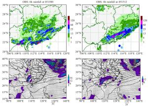
图 1 2017年5月15日00—06时(a)和12—18时(b)6小时的累积降水及15日00时(c)和12时(d)850 hPa的风场和500 hPa高度场
a、b中填色部分为降水量,单位:mm/h;c、d中填色部分为风速,单位:m/s。
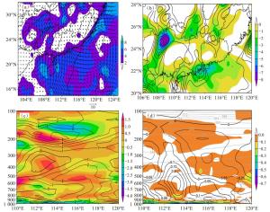
图 2 5月15日00时975 hPa的风场(a)、1 000 hPa的涡、散度(b,阴影部分表示散度)以及涡、散度沿22 °N的垂直剖面(c,阴影部分为散度,)和垂直速度、水汽通量散度、假相当位温沿22 °N的垂直剖面(d,阴影部分为水汽通量散度,黑实线为垂直速度,灰色虚线为假相当位温)
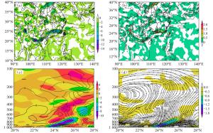
图 5 850 hPa涡散度(a,阴影部分是散度,单位:10-5 s-1,锋生函数的辐合项和变形项(b,阴影部分是变形项,单位:10-9 K/(m·s)),涡度散度沿114 °E的垂直剖面(c,阴影部分为散度),沿114 °E的垂直环流、θse及水汽通量散度(d,阴影部分为水汽通量散度,灰虚线为θse)
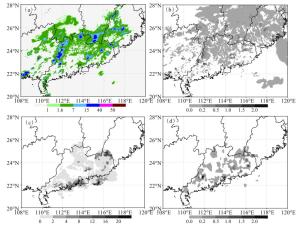
图 8 2017年5月15日04时的模式降水(a,单位:mm)、模式模拟的潜热(b,单位:10-4 K/s)、观测的降水率(c,单位:mm)和雷达反演的潜热(d,单位:10-4 K/s)
-
[1] 孙建华, 赵思雄.一次罕见的华南大暴雨过程的诊断与数值模拟研究[J].大气科学, 2000, 24(3) : 381-392. [2] 王立琨, 郑永光, 王洪庆, 等.华南暴雨试验过程的环境场和云团特征的初步分析[J].气象学报, 2001, 59(1):115-119. [3] 王鹏云, 阮征, 康红文.华南暴雨中云物理过程的数值研究[J].应用气象学报, 2002, 13(1):78-87. [4] 孙健, 赵平, 周秀骥. —次华南暴雨的中尺度结构及复杂地形的影响[J].气象学报, 2002, 60(3):333-342. [5] 柳艳菊, 丁一汇. 1998年南海季风爆发时期中尺度对流系统的研究Ⅱ :中尺度对流系统发生发展的大尺度条件[J].气象学报, 2005, 63 (4):431-442 [6] 文莉娟, 程麟生, 隆霄."98. 5"华南前汛期暴雨的非静力数值模拟和中尺度系统分析[J].高原气象, 2005, 24(2):223-231. [7] 慕建利, 王建捷, 李泽椿. 2005年6月华南特大连续性暴雨的环境条件和中尺度扰动分析[J].气象学报, 2008, 66(3):437-451. [8] 傅慎明, 赵思雄, 孙建华, 等.一类低涡切变型华南前汛期致洪暴雨的分析研究[J].大气科学, 2010, 34(2):235-252. [9] 赵玉春, 王叶红, 崔春光.大对流有效位能和条件不稳定下地形降水的三维理想数值研究[J].气象学报, 2011, 69(5):782-798. [10] 胡宁, 汪会.华南一次强对流天气过程中环境条件对MCS形态特征的影响[J].热带气象学报, 2019, 35(5):681-693. [11] 赵玉春, 李泽春, 肖子牛.华南锋面与暖区暴雨个例对比分析[J].气象科技, 2008, 36(1):47-54. [12] 梁巧倩, 蒙伟光, 孙喜艳, 等.广东前汛期锋面强降水和后汛期季风强降水特征对比分析[J].热带气象学报, 2019, 35(1):51-62. [13] 林晓霞, 冯业荣, 张诚忠, 等.华南一次暴雨过程热力和动力特征的诊断分析[J].热带气象学报, 2017, 33(6):975-984. [14] 曾智琳, 谌芸, 朱克云. 2017年6月一次华南沿海强降水的对流性特征及热动力机制研究[J].大气科学, 2019, 43(6):1 295-1 312. [15] 陈敏, 陶祖钰, 郑永光, 等.华南前汛期锋面垂直环流及其与中尺度对流系统的相互作用[J].气象学报, 2007, 65(5):785-791. [16] 张亚妮, 姚秀萍, 于超.高层动力强迫对回流型华南暖区暴雨影响的个例研究[J].热带气象学报, 2019, 35(2):166-176. [17] 苗春生, 杨艺亚, 王坚红, 等.两类华南沿海暖区暴雨特征及热力发展机制对比研究[J].热带气象学报, 2017, 33(1):53-63. [18] 杨辉, 李崇银, 潘静.一次引发华南大暴雨的南海季风槽异常特征及其原因分析[J].气候与环境研究, 2011, 16(1):1-14. [19] HALVERSON J, GARSTANG M, SCALA J, et al. Water and energy budgets of a Florida 377 mesoscale convective system: A combined observational and modeling study[J]. Mon Wea Rev, 1996, 124(6): 1 161-1 180 [20] JONES C D, MACPHERSON B. A latent heat nudging scheme for the assimilation of precipitation 380 data into an operational mesoscale model[J]. Meteorol Appl, 1997, 4: 269-277. [21] STEPHAN K, KLINK S, SCHRAFF C. Assimilation of radar-derived rain rates into the 382 convective-scale model COSMO-DE at DWD[J]. Q J R Meteorol Soc, 2008, 134: 1 315-1 326. [22] MANOBIANCO J, KOCH S, KARYAMPUDI V M. The impact of assimilating satellite-derived precipitation rates on numerical simulations of the ERICA IOP 4 cyclone[J]. Mon Wea Rev, 1994, 122(2): 341-365. [23] 张诚忠, 薛纪善, 冯业荣等, 雷达反演潜热在华南区域数值模式短时临近降水预报应用试验[J].热带气象学报, 2017, 33(5): 577-587. [24] 苏勇, 沈学顺, 陈子通, 等. GRAPES_GFS中三维参考大气的研究:理论设计和理想试验[J].气象学报, 2018, 76(2), 241-254. [25] ZHONG S X, CHEN Z T, WANG G, et al. Improved forecasting of cold air outbreaks over southern China through orographic gravity wave drag parameterization[J]. J Trop Meteor, 2016, 22(4):522-534. [26] 陈子通, 戴光丰, 钟水新, 等.中国南海台风模式(TRAMS-v2.0)技术特点及其预报性能[J].热带气象学报, 2016, 32(6):831-840. [27] 陈子通, 戴光丰, 罗秋红, 等.模式动力过程与物理过程耦合及其对台风预报的影响研究[J].热带气象学报, 2016, 32(1):1-8. [28] 徐道生, 张艳霞, 王刚, 等. meso-SAS对流参数化方案的改进及其在9km分辨率模式中的应用[J].热带气象学报, 2015, 31(5):608-618. [29] HOUZE JR R A. Cloud Dynamics[M]. New York: Academic Press, 1993: 278-329. [30] COTTON W R, ANTHES R A.风暴和云动力学[M].北京:气象出版社, 1993:491-530, 372. -

 下载:
下载:


 点击查看大图

计量
- 文章访问数: 489
- HTML全文浏览量: 97
- PDF下载量: 123
- 被引次数: 0
 粤公网安备 4401069904700003号