


ANALYSIS OF THE VERTICAL STRUCTURE OF PRECIPITATION IN SOUTH CHINA BASED ON DUAL-FREQUENCY SPACEBORNE PRECIPITATION RADAR GPM PRODUCT
-
摘要: 华南汛期作为我国雨季爆发的第一阶段一直是预报与研究的热点问题,对其降水-云宏微观垂直特性的认识还不够深入。双频星载雷达资料对强、弱降水三维探测进行优化,并补充对洋面降水的探测。借助这两方面优势,对华南对流性、层云性两类主要降水类型的垂直特征进行统计,分析降水反射率因子与降水粒子垂直分布、亮带特征与垂直分层降水贡献,对比华南陆地在回波顶高方面与南海洋面的异同,最后针对华南前后汛期的降水垂直分布特征进行分析。(1)对流性降水反射率因子快速增长区域主要发生在低层,层云性降水反射率因子快速增长区域位于亮带层附近。(2)当发生强降水时,对流性降水的粒子浓度并不是总高于层云性降水,但前者粒子半径大于后者;强层云性降水往往来自于大小均一的粒子聚集,并没有形成更大直径的液滴。(3)华南陆地回波顶高季节变化较南海洋面强烈,浅薄对流降水发生频率受季风影响从春至秋存在先增后减特征,深对流发生频率在夏季增幅显著。南海地区回波顶高虽无明显季节变化但在3 km和5.5 km存在明显的双峰特征。(4)前汛期对流性降水的高浓度、大尺度的粒子更利于向更高高度发展,而层云性降水粒子浓度及半径的垂直分布在华南前后汛期无明显差异。前后汛期回波顶高异同主要出现在广西中部,广东中部和沿海地区。Abstract: Using the dual-frequency precipitation radar GPM 2ADPR satellite data from March 2014 to March 2018, this study analyzed the vertical structure of convective and stratiform precipitation over south China. The results are as follows. (1) The rapid growth of convective precipitation reflectivity mainly occurs in the lower layer, and the rapid growth of the stratiform precipitation is located near the bright zone. (2) The hydrometeor profile shows that the particle concentration of convective precipitation is not always higher than that of the stratiform precipitation, and the former actually has a larger particle size than the latter. Strong stratiform precipitation often comes from the aggregation of uniform hydrogenic particles, suggesting no larger droplets or raindrops are formed. (3) The seasonal variation of the top height of land storms in south China is stronger than that of the sea surface of the South China Sea. The frequency of shallow convective precipitation is affected by the monsoon from spring to autumn. The frequency of deep convection increases significantly in summer. Although there is no obvious seasonal variation in the echo top height in the South China Sea, there are obvious bimodal characteristics at 3 km and 5.5 km. (4) The high concentration and large-scale particles of convective precipitation in the annually first rainy season are more likely to develop at higher levels, while the vertical distribution of the concentration and radius of the stratiform precipitation has no significant difference in the two rainy seasons in south China. The differences of echo top height in the two rainy seasons are mainly found in central Guangxi, central Guangdong and coastal areas.
-
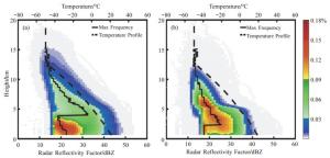
图 2 雷达反射率因子垂直结构
a.对流性降水;b.层云性降水。填色为雷达反射率因子出现的频率;黑色实线为反射率因子最大频率廓线,对应底部横坐标;黑色虚线为温度垂直廓线,对应顶部横坐标。
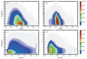
图 6 对流性降水与层云性降水粒子信息DSD垂直结构
a.对流性降水粒子浓度参数dBNw;b.层云性降水粒子浓度参数dBNw;c.对流性降水粒子半径dm;d.层云性降水粒子半径dm。
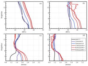
图 7 对应不同量级地面降水的降水粒子信息DSD廓线
雨强单位:mm/h。a.对流性降水粒子浓度参数dBNw;b.层云性降水粒子浓度参数dBNw;c.对流性降水粒子直径dm;d.层云性降水粒子半径dm。
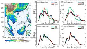
图 11 对流性和层云性降水回波顶高PDF季节分布
a.华南与南海海陆划分;b.华南陆地对流性降水;c.华南陆地层云性降水;d.南海洋面对流性降水;e.南海洋面层云性降水。
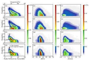
图 12 华南前汛期(a、e、i、c、g、k)、后汛期(b、f、j、d、h、l)对流性降水(a、b、e、f、i、j)和层云性降水(c、d、g、h、k、l)的反射率因子、粒子浓度及半径的垂直分布
a~d.雷达反射率因子(dBZ);e~h.粒子浓度参数dBNw;i~l.粒子浓度半径dm。
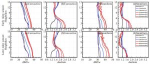
图 13 华南前汛期(a~d)、后汛期(c~h)对应不同量级地面降水的降水粒子信息DSD廓线
雨强单位:mm/h。a、b、e、f.对流性降水;c、d、g、h.层云性降水;a、c、e、g.粒子浓度参数dBNw;b、d、f、h.粒子浓度半径dm。
表 1 2014年3月—2018年3月GPM DPR探测的华南地区降水样本频次
降水 样本数 样本数比重 降水量比重 平均地表雨强/(mm/h) 对流性降水 97 485 33.8% 55.7% 4.778 层云性降水 188 022 65.1% 44.1% 1.958  下载: 导出CSV
表 2 华南地区对流性降水和层云性降水层次高度划分
季节 对流性降水 层云性降水 夏 0.5~4.0 km 蒸发层 0.5~5.0 km 均一层 4~5 km 碰并增长层 5~6 km 冰水混合层 5~7 km 冰水混合层 6~12 km 冰晶层 7~12 km 冰晶层 冬 0.5~3.0 km 碰并增长层 0.5~3.5 km 均一层 3~5 km 冰水混合层 3.5~5.0 km 冰水混合层 5~12 km 冰晶层 5~12 km 冰晶层
下载: 导出CSV
-
[1] HOBBS P V. Research on clouds and precipitation: Past, present, and future, Part Ⅰ[J]. Bull Amer Meteor Soc, 1989, 70(3): 282-285. [2] PRUPPACHER H R, KLETT J D. Microphysics of clouds and precipitation[M]. Springer Science & Business Media, 2010. [3] HOUZE R A. Cloud Clusters and large-scale vertical motions in the tropics[J]. J Meteor Soc of Japan, 1982, 60(1): 396-410. [4] 王在志, 闫敬华.水成物分析及在数值模式中的应用综述[J].热带气象学报, 2007, 23(1): 85-89. [5] DAS S, MAITRA A. Vertical profile of rain: Ka band radar observations at tropical locations[J]. J Hydrology, 2016, 534(1): 31-41. [6] CONWAY J W, ZRNIĆ D S. A study of embryo production and hail growth using Dual-Doppler and multiparameter radars[J]. Mon Wea Rev, 1993, 121(9): 2 511-2 528. [7] SHENK W E. Cloud top height variability of strong convective cells[J]. J Appl Meteor, 2010, 13(8): 917-922. [8] 李南, 卢美圻.星载测雨雷达简介[J].科教文汇, 2015(27): 175-177. [9] CHANDRASEKAR V, LE M. Evaluation of profile classification module of GPM-DPR algorithm after launch[C]. Geoscience and Remote Sensing Symposium. IEEE, 2015: 5 174-5 177. [10] 金晓龙, 邵华, 张弛, 等. GPM卫星降水数据在天山山区的适用性分析[J].自然资源学报, 2016, 31(12): 2 074-2 085. [11] 卢美圻, 魏鸣. GPM资料在分析"彩虹"台风降水垂直结构中的应用[J].遥感技术与应用, 2017, 32(5): 904-912. [12] TANG G, ZENG Z, LONG D, et al. Statistical and hydrological comparisons between TRMM and GPM Level-3 products over a midlatitude basin: Is Day-1 IMERG a Good Successor for TMPA 3B42V7?[J]. J Hydrometeorology, 2016, 17(1): 121-137. [13] DURDEN S L. Relating GPM radar reflectivity profile characteristics to path-integrated attenuation[J]. IEEE Transactions on Geoscience & Remote Sensing, 2018, 56(7): 4 065-4 074. [14] FU Y. The variability of tropical precipitation profiles and its impact on microwave brightness temperatures as inferred from TRMM data[J]. J Appl Meteor, 2001, 40(40): 2 130-2 143. [15] CHEN F, FU Y, LIU P, et al. Seasonal variability of storm top altitudes in the tropics and subtropics observed by TRMM PR[J]. Atmos Res, 2016, 169(1): 113-126. [16] SEO E K. Characteristics of summer rainfall over East Asia as observed by TRMM PR[J]. Journal of the Korean Earth Science Society, 2011, 32(1): 33-45. [17] 傅云飞, 曹爱琴, 李天奕, 等.星载测雨雷达探测的夏季亚洲对流与层云降水雨顶高度气候特征[J].气象学报, 2012, 70(3): 436-451. [18] 仲凌志, 陈林, 杨蓉芳, 等.基于星载测雨雷达2004-2014年观测的川渝地区降水垂直结构的气候特征[J].气象学报, 2018, 76(2): 213-227. [19] KOBAYASHI K, SHIGE S, YAMAMOTO M K. Vertical gradient of stratiform radar reflectivity below the bright band from the tropics to the extratropical latitudes seen by GPM: Vertical gradient of stratiform radar reflectivity seen by GPM[J]. Q J R Meteor Soc, 2018, 144(1): 165-175 [20] 周嘉健, 肖辉, 潘雯菁, 等.基于雷达反射率因子的降水性层状云中雨滴谱参数的反演方法与检验研究[J].热带气象学报, 2018, 34(2): 250-259. [21] ULBRICH C W. Natural variations in the analytical form of the raindrop size distribution[J]. J Climate Appl Meteor, 1983, 22(10): 1 764-1 775. [22] IGUCHI T, SETO S, MENEGHINI R, et al. GPM / DPR level-2 algorithm theoretical basis document[R]. NASA. https://pmm.nasa.gov/resources/documents/gpmdpr-level-2-algorithm-theoretical-basis-document-atbd, 2010, [2017-02-24] [23] LE M, CHANDRASEKAR V. Hydrometeor profile characterization method for dual-frequency precipitation radar onboard the GPM[J]. IEEE Transactions on Geoscience & Remote Sensing, 2013, 51(6): 3 648-3 658. [24] LE M, CHANDRASEKAR V. Precipitation type classification method for dual-frequency precipitation radar (DPR) onboard the GPM[J]. IEEE Transactions on Geoscience & Remote Sensing, 2013, 51(3): 1 784-1 790. [25] AWAKA J, LE M, CHANDRASEKAR V, et al. Rain type classification algorithm module for GPM dual-frequency precipitation radar[J]. J Atmos Ocean Techn, 2016, 33(9): 1 887-1 898. [26] KOTSUKI S, TERASAKI K, MIYOSHI T. GPM/DPR precipitation compared with 3.5-km-resolution NICAM simulations[J]. Scientific Online Letters on the Atmosphere Sola, 2014, 10(1): 204-209. [27] CHANDRASEKAR V, LE M. Evaluation of profile classification module of GPM-DPR algorithm after launch[C]. Geoscience and Remote Sensing Symposium. IEEE, 2015: 5 174-5 177. [28] 余占猷.利用DPR和GMI探测结果对东亚降水云的个例分析研究[D].合肥: 中国科学技术大学, 2016. [29] 张奡祺, 傅云飞. GPM卫星双频测雨雷达探测降水结构的个例特征分析[J].大气科学, 2018, 42(1): 33-51. [30] FU Y F, LIN Y H, LIU G S, et al. Seasonal characteristics of precipitation in 1998 over East Asia as derived from TRMM PR[J]. Adv Atmos Sci, 2003, 20(4): 511-529. [31] JOHNSON R H, RICKENBACH T M, RUTLEDGE S A, et al. Trimodal characteristics of tropical convection[J]. J Climate, 1999, 12(8): 2 397-2 418. [32] 尹金方, 王东海, 翟国庆, 等.基于星载云雷达资料的东亚大陆云垂直结构特征分析[J].气象学报, 2013, 71(1): 121-133. [33] 顾震潮, 詹丽珊.起伏条件下云雾的重力碰并生长[J].气象学报, 1962(4): 37-43. [34] 徐华英, 顾震潮.起伏条件下重力碰并造成的暖性薄云降水[J].气象学报, 1963(1): 110-116. [35] BERNE A, DELRIEU G, ANDRIEU H, et al. Influence of the vertical profile of reflectivity on radar-estimated rain rates at short time steps[J]. J Hydrometeorology, 2004, 5(2): 296-310. [36] DAS S, TALUKDAR S, BHATTACHARYA A, et al. Vertical profile of ZR relationship and its seasonal variation at a tropical location[C]. Applied Electromagnetics Conference (AEMC). IEEE, 2011: 1-4. [37] WEN Y, CAO Q, KIRSTETTER P E, et al. Incorporating NASA spaceborne radar data into NOAA national mosaic QPE system for improved precipitation measurement: a physically based vpr identification and enhancement method[J]. J Hydrometeorology, 2013, 14(4): 1 293-1 307. [38] 傅云飞, 宇如聪, 崔春光, 等.基于热带测雨卫星探测的东亚降水云结构特征的研究[J].暴雨灾害, 2007, 26(1): 11-22. [39] ARKIN P A, ARDANUY P E. Estimating climatic-scale precipitation from space: a review[J]. J Climate, 1989, 2(11): 1 229-1 238. [40] 李春晖, 梁建茵, 郑彬, 等.南海夏季风北推时间及相关环流变化特征[J].应用气象学报, 2007, 18(2): 202-210. [41] 吴晓彤, 梁必骐.初夏南海海温对华南降水影响的数值模拟[J].海洋学报, 1995, 17(2): 38-43. [42] 柯史钊, 黄健.华南海陆风的数值模拟[J].热带气象学报, 1993, 9(2): 169-176. [43] 陈举, 施平, 杜岩, 等. TRMM卫星降雨雷达观测的南海降雨空间结构和季节变化[J].地球科学进展, 2005, 20(1): 29-35. [44] 叶清文, 李江南, 罗家林, 等.基于TRMM卫星探测的南海及周边地区降水、云和潜热特征的比较研究[J].热带气象学报, 2018, 34(3): 419-432. [45] CHEN F, FU Y, LIU P, et al. Seasonal variability of storm top altitudes in the tropics and subtropics observed by TRMM PR[C]// EGU General Assembly Conference. EGU General Assembly Conference Abstracts, 2016. [46] SHORT D A, NAKAMURA K. TRMM Radar Observations of Shallow Precipitation over the Tropical Oceans[J]. J Climate, 2000, 13(23): 4 107-4 124. [47] 伍红雨, 杜尧东, 秦鹏.华南暴雨的气候特征及变化[J].气象, 2011, 37(10): 1 262-1 269. [48] 郑彬, 梁建茵, 林爱兰, 等.华南前汛期的锋面降水和夏季风降水Ⅰ.划分日期的确定[J].大气科学, 2006, 30(6): 1 207-1 216. [49] 郑彬, 谷德军, 李春晖.华南前汛期的锋面降水和夏季风降水Ⅱ.空间分布特征[J].大气科学, 2007, 31(3): 495-504. [50] 刘亚楠, 王东海, 李国平, 等.南海夏季风爆发前后华南前汛期降水日变化对比分析[J].热带气象学报, 2019, 35(3):365-378. -


 点击查看大图

计量
- 文章访问数: 456
- HTML全文浏览量: 57
- PDF下载量: 33
- 被引次数: 0
 粤公网安备 4401069904700003号