


COMPARISON OF INNER-CORE STRUCTURE CHANGES DURING RAPID INTENSIFICATION BETWEEN TYPHOON RAMMASUN (2014) AND HURRICANE WILMA (2005)
-
摘要: 热带气旋的快速增强机制目前仍然不太清楚,不少研究开始关注快速增强过程中热带气旋内核结构的变化。通过比较模拟的西北太平洋超强台风Rammasun (2014)和大西洋5级飓风Wilma (2005)快速增强过程中内核结构的变化特点,理解内核结构在快速增强过程中的变化特点。飓风Wilma是一个典型的快速增强热带气旋,快速增强期间具有弱的环境垂直切变、对称的眼墙、较小的中心倾斜以及比较直立的眼墙。但是,台风Rammasun快速增强发生在较强切变(超过10 m/s)环境下,眼墙对流呈高度不对称,强对流基本固定在台风中心的南侧。整个快速增强期间,Rammasun在垂直方向上维持较大的中心倾斜以及较大的眼墙倾斜。结果表明,快速增强也可能在不完全对称的内核结构和倾斜垂直结构的情况下发生。Abstract: The rapid intensification mechanism of tropical cyclones is still unclear. More recent studies of rapid intensification begin to focus on the processes in the inner-core structure of tropical cyclones. In this study, by comparing the changes of the inner-core structure of the simulated super typhoon Rammasun (2014) in the Pacific Northwest and the Atlantic Category 5 hurricane Wilma (2005), we try to understand the role of the inner-core structure changes in the rapid intensification processes. Wilma is a typical tropical cyclone of rapid intensification with a weak ambient vertical wind shear, a symmetrical eyewall, a small vortex tilt, and a relatively upright eyewall during the rapid intensification process. However, the rapid intensification of super typhoon Rammasun (2014) occurs in an environment with strong vertical wind shear (>10 m/s). Besides, the convections are highly asymmetric with deep convections fixed on the south side of the typhoon center. During rapid intensification period, Rammasun maintains a large vortex tilt and eyewall tilt in the vertical direction. Results show that the rapid intensification of tropical cyclones may also occur when there is an incomplete symmetric inner-core structure and inclined vertical structure.
-
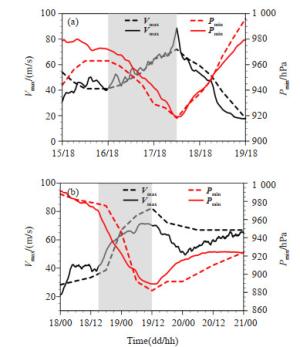
图 2 台风Rammasun (2014)(a)和飓风Wilma (2005)(b)模拟(Sim,实线)和观测(Obs,虚线)的强度对比
黑色:10 m高度最大风速(Vmax,单位:m/s),红色:最低海平面气压(Pmin,单位:hPa)。阴影区域为对应热带气旋的快速增强阶段,观测资料采用JTWC最佳路径强度资料。

图 3 台风Rammasun (2014)(a)和飓风Wilma (2005)(b)模拟的环境垂直风切变(红色,VWS,单位:m/s)和强度(黑色,Vmax,单位:m/s)时间序列
横坐标代表相对于快速增强开始的小时数,负值表示快速增强发生前,正值表示快速增强发生后(后文均使用一致的时间轴)。

图 4 台风Rammasun (2014)(a)和飓风Wilma (2005) (b)模拟的3 km高度的时间-半径方位角平均切向风演变(阴影,单位:m/s)
黑色线为3 km高度的大风半径,单位:km。
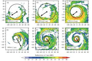
图 5 台风Rammasun (2014)(a~c)和飓风Wilma (2005)(d~f)模拟的3 km高度雷达反射率(阴影,单位:dBZ)
a~c分别代表台风Rammasun快速增强发生前3小时(-3 h)、快速增强发生后3小时(3 h)、最大强度时刻(36 h),d~f分别代表飓风Wilma快速增强发生前3小时(-3 h)、快速增强发生后3小时(3 h)、最大强度时刻(21 h)。矢量箭头:对应时刻的环境垂直风切变,分别为:15.2、16.5、12.0、5.1、3.4以及1.2 m/s。圆:对应时刻3 km高度的大风半径。

图 6 台风Rammasun (2014)(a~c)和飓风Wilma (2005)(d~f)模拟的10 m高度的全风速(阴影,单位:m/s)
a~c分别代表台风Rammasun快速增强发生前3小时(-3 h)、快速增强发生后3小时(3 h)、最大强度时刻(36 h),d~f分别代表飓风Wilma快速增强发生前3小时(-3 h)、快速增强发生后3小时(3 h)、最大强度时刻(21 h)。
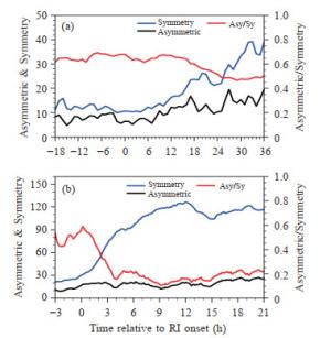
图 7 台风Rammasun (2014)(a)和飓风Wilma (2005)(b)模拟的3 km高度位涡的方位对称分量(蓝色,Symmetry)、一波分量(黑色,Asymmetric)最大振幅(对应左边的纵坐标轴)以及最大振幅比(红色,Asy/Sy,计算方法:一波分量与对称分量最大振幅的比,对应右边的纵坐标轴)时间序列
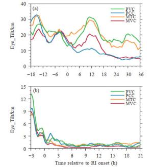
图 8 台风Rammasun (2014)(a)和飓风Wilma (2005) (b)模拟的中心位置的垂直倾斜(计算方法:8 km与2 km高度中心相对位置,单位:km)时间序列
MVC:气压方差中心,MTC:最大对称风中心,PCC:气压权重中心,PVC:位涡权重中心。

图 9 台风Rammasun (2014)(a)和飓风Wilma (2005)(b)模拟的标准化后的中心倾斜(计算方法:中心倾斜(Tilt)除2~ 8 km高度层之间平均的大风半径(RMW))时间序列

图 10 台风Rammasun (2014)(a)和飓风Wilma (2005)(b)模拟的不同高度上的方位角平均最大切向风(实线,Vt,单位:m/s)和大风半径(虚线,RMW,单位:km)时间序列
黑色、蓝色和红色曲线分别表示2 km、5 km和8 km高度。
-
[1] ELSBERRY R L, LAMBERT T D B, BOOTHE M A. Accuracy of Atlantic and eastern North Pacific tropical cyclone intensity forecast guidance[J]. Wea Forecasting, 2007, 22(4): 747-762. [2] ROGERS R P, REASOR, ZHANG J A. Multiscale structure and evolution of Hurricane Earl (2010) during rapid intensification[J]. Mon Wea Rev, 2015, 143(2): 536-562. [3] KAPLAN J, DEMARIA M. Larger-scale characteristics of rapidly intensifying tropical cyclones in the north Atlantic basin[J]. Wea Forecasting, 2003, 18(6): 1 093-1 108. [4] HOLLIDAY C R, THOMPSON A H. Climatological characteristics of the rapidly intensifying typhoons[J]. Mon Wea Rev, 1979, 107(8): 1 022-1 034. [5] QIN N, ZHANG D L, LI Y. A statistical analysis of steady eyewall sizes associated with rapidly intensifying hurricanes[J]. Wea Forecasting, 2016, 31(3): 737-742. [6] GRAY M W. Global view of the origin of tropical disturbances and storms[J]. Mon Wea Rev, 1968, 96(114): 669-700. [7] MERRILL R T. Environmental influences on hurricane intensification[J]. J Atmos Sci, 1988, 45(11): 1 678-1 687. [8] HENDRICKS E A, PENG M S, FU B, et al. Quantifying environmental control on tropical cyclone intensity change[J]. Mon Wea Rev, 2010, 138(8): 3 243-3 271. [9] ROGERS R, REASOR P, LORSOLO S. Airborne Doppler observation of the inner-core structural differences between intensifying and stead-state tropical cyclones[J]. Mon Wea Rev, 2013, 141(9): 2 970-2 991. [10] ROGERS R, COAUTHORS. Observations of the structure and evolution of Hurricane Edouard (2014) during Intensity change. Part Ⅱ: Kinematic structure and the distribution of deep convection[J]. Mon Wea Rev, 2016, 144(9): 3 355-3 376. [11] LIU Y, ZHANG D L, YAU M K. A multiscale numerical study of hurricane Andrew (1992). Part Ⅱ: Kinematics and inner-core structures[J]. Mon Wea Rev, 1999, 127(11): 2 597-2 616. [12] LEE W C, BELL M M. Rapid intensification, eyewall contraction, and breakdown of Hurricane Charley (2004) near landfall[J]. Geophys Res Lett, 2007, 34(2): L02802. [13] CARRASCO C A, LANDSEA C. W, LIN Y L. The influence of tropical cyclone size on its intensification[J]. Wea Forecasting, 2014, 29(3): 582-590. [14] TAO D, ZHANG F. Evolution of dynamic and thermodynamic structures before and during rapid intensification of tropical cyclones: sensitivity to vertical wind shear[J]. Mon Wea Rev, 2019, 147(4): 1 171-1 191. [15] KIEU C Q. An investigation into the contraction of the hurricane radius of maximum wind[J]. Meteorol Atmos Phys, 2012, 115(1-2): 47-56. [16] STERN D P, VIGH J L, NOLAN D S, et al. Revisiting the relationship between eyewall contraction and intensification[J]. J Atmos Sci, 2015, 72(4): 1 283-1 306. [17] WANG H, WANG Y. A numerical study of Typhoon Megi (2010): PartⅠ: Rapid intensification[J]. Mon Wea Rev, 2014, 142(1): 29-48. [18] CHEN X M, WANG Y Q, ZHAO K, et al. A numerical study on rapid intensification of Typhoon Vicente (2012) in the South China Sea. Part Ⅰ: Verification of simulation, storm-scale evolution, and environmental contribution[J]. Mon Wea Rev, 2017, 145(3): 877-898. [19] GUIMOND S R, HEYMSFIELD G M, TURK F J. Multiscale observations of Hurricane Dennis (2005): The effects of hot towers on rapid intensification[J]. J Atmos Sci, 2010, 67(3): 633-654. [20] CHEN H, ZHANG D L. On the rapid intensification of Hurricane Wilma (2005). Part Ⅱ: Convective bursts and the upper-level warm core [J]. J Atmos Sci, 2013, 70(1): 146-162. [21] HAZELTON A T, HART R E, ROGERS R F. Analyzing simulated convective bursts in two Atlantic Hurricanes. Part Ⅱ: Intensity change due to Bursts[J]. Mon Wea Rev, 2017, 145(8): 3 095-3 117. [22] ZHANG D L, CHEN H. Importance of the upper-level warm core in the rapid intensification of a tropical cyclone[J]. Geophys Res Lett, 2012, 39(2): L02806. [23] RIOS-BERRIOS R, DAVIS C A, TORN R D. A hypothesis for the intensification of tropical cyclones under moderate vertical wind shear [J]. J Atmos Sci, 2018, 75(12): 4 149-4 173. [24] HARNOS D S, NESBITT S W. Convective structure in rapidly intensifying tropical cyclones as depicted by passive microwave measurements[J]. Geophys Res Lett, 2011, 38(7): L07805. [25] GUIMOND S R, HEYMSFIELD G M, REASOR P D, et al. The rapid Intensification of Hurricane Karl (2010): New remote sensing observations of convective bursts from the Global Hawk Platform[J]. J Atmos Sci, 2016, 73(9): 3 617-3 639. [26] ROGERS R. Convective-scale structure and evolution during a high-resolution simulation of tropical cyclone rapid intensification[J]. J Atmos Sci, 2010, 67(1): 44-70. [27] MIYAMOTO Y, TAKEMI T. A transition mechanism for the axisymmetric spontaneous intensification of tropical cyclones[J]. J Atmos Sci, 2013, 70(1): 112-129. [28] MIYAMOTO Y, TAKEMI T. A triggering mechanism for rapid intensification of tropical cyclones[J]. J Atmos Sci, 2015, 72(7): 2 666-2 681. [29] CHANG C C, WU C C. On the processes leading to the rapid intensification of Typhoon Megi (2010)[J]. J Atmos Sci, 2017, 74(4): 1 169- 1 200. [30] MOLINARI J, VOLLARO D. Rapid intensification of a sheared tropical storm[J]. Mon Wea Rev, 2010, 138(10): 3 869-3 885. [31] MOLINARI J, DODGE P, VOLLARO D, et al. Mesoscale aspects of the downshear reformation of a tropical cyclone[J]. J Atmos Sci, 2006, 63(1): 341-354. [32] REASOR P D, EASTIN M D, GAMACHE J F. Rapidly intensifying Hurricane Guillermo (1997). Part Ⅰ: Low-wavenumber structure and evolution[J]. Mon Wea Rev, 2009, 137(2): 603-631. [33] GABRIEL S L, ZAWISLAK J, ZIPSER E J, et al. The role of observed environmental conditions and precipitation evolution in the rapid intensification of Hurricane Earl (2010)[J]. Mon Wea Rev, 2015, 143(6): 2 207-2 223. [34] CHEN H, GOPALAKRISHNAN S G. A study on the asymmetric rapid intensification of Hurricane Earl (2010) using the HWRF system[J]. J Atmos Sci, 2015, 72(2): 531-550. [35] LEIGHTON H, GOPALAKRISHNAN S G, ZHANG J A, et al. Azimuthal distribution of deep convection, environmental factors, and tropical cyclone rapid intensification: A perspective from HWRF ensemble forecasts of Hurricane Edouard (2014)[J]. J Atmos Sci, 2018, 75 (1): 275-295. [36] FRANK W M, RITCHIE E A. Effects of vertical wind shear on the intensity and structure of numerically simulated hurricanes[J]. Mon Wea Rev, 2001, 129(9): 2 249-2 269. [37] BRAUN S A, WU L G. A numerical study of Hurricane Erin (2001). Part Ⅱ: Shear and the organization of eyewall vertical motion[J]. Mon Wea Rev, 2007, 135(4): 1 179-1 194. [38] MIYAMOTO Y, NOLAN D S. Structural changes preceding rapid intensification in tropical cyclones as shown in a large ensemble of idealized simulations[J]. J Atmos Sci, 2018, 75(2): 555-569. [39] HONG S Y, LIM J O J. The WRF single-moment 6-class microphysics scheme (WSM6)[J]. J Korean Meteor Soc, 2006, 42(2): 129-151. [40] DUDHIA J. Numerical study of convection observed during the winter monsoon experiment using a mesoscale two-dimensional model[J]. J Atmos Sci, 1989, 46(20): 3 077-3 107. [41] MLAWER E J, TAUBMAN S J, BROWN P D, et al. Radiative transfer for inhomogeneous atmosphere: RRTM, a validated correlated-k model for the longwave[J]. J Geophys Res, 1997, 102 (D14): 16 663-16 682. [42] KAIN J S, FRITCH J M. Convective parameterization for mesoscale models: The Kain-Fritch scheme. The representation of cumulus convection in numerical models[J]. Meteor Monogr Amer Meteor Soc, 1993, 24(1): 165-170. [43] NOH Y, CHEON W G, HONG S Y, et al. Improvement of the K-Profile model for the planetary boundary layer based on large eddy simulation data[J]. Boundary-Layer Meteorology, 2003, 107(2): 401-427. [44] CHEN H, ZHANG D L, CARTON J, et al. On the rapid intensification of Hurricane Wilma (2005). Part Ⅰ: Model prediction and structural changes[J]. Wea Forecasting, 2011, 26(6): 885-901. [45] 秦南南.热带气旋快速增强期间眼墙尺度变化机制的研究[D].南京: 南京信息工程大学, 2018. [46] XU J, WANG Y. Sensitivity of tropical cyclone inner core size and intensity to the radial distribution of surface entropy flux[J]. J Atmos Sci, 2010, 67(6): 1 831-1 852. [47] GUO X, TAN Z M. Tropical cyclone fullness: A new concept for interpreting storm intensity[J]. Geophys Res Lett, 2017, 44(9): 4 324- 4 331. [48] BRAUN S A. A cloud-resolving simulation of Hurricane Bob (1991): Storm structure and eyewall buoyancy[J]. Mon Wea Rev, 2002, 130 (6): 1 573-1 592. [49] WU L G, BRAUN S A, HALVERSON J, et al. A Numerical Study of Hurricane Erin (2001). Part Ⅰ: Model verification and storm evolution [J]. J Atmos Sci, 2006, 63(1): 65-86. [50] NGUYEN L T, MOLINARI J, THOMAS D. Evaluation of tropical cyclone center identification methods in numerical models[J]. Mon Wea Rev, 2014, 142(11): 4 326-4 339. [51] REASOR P D, MONTGOMERY M T. Three-dimensional alignment and corotation of weak, TC-like vortices via linear vortex Rossby waves[J]. J Atmos Sci, 2001, 58(16): 2 306-2 330. [52] STERN D P, NOLAN D S. On the vertical decay of the maximum tangential winds in tropical cyclones[J]. J Atmos Sci, 2011, 68(9): 2 073- 2 094. [53] 周星阳, 吴立广, 刘青元.次千米至次百米高分辨率模拟的热带气旋眼墙低层极端上升运动特征分析[J].热带气象学报, 2019, 35(1): 113- 124. -

 下载:
下载:


 点击查看大图

计量
- 文章访问数: 666
- HTML全文浏览量: 73
- PDF下载量: 36
- 被引次数: 0
 粤公网安备 4401069904700003号