


COMPARATIVE ANALYSIS ON BACKFLOW WARM-SECTOR RAINSTORM CASES IN DOUBLE RAIN BELTS PROCESS
-
摘要: 利用常规观测资料、NCEP 1 °×1 °FNL资料、自动站降水资料,对华南两次双雨带过程中的回流暖区暴雨个例进行了对比分析,结果表明:(1)与暖湿的南到西南气流相比,变性高压脊后部回流的东到东南气流具有一定干冷属性,边界层两支不同性质的气流汇合形成辐合渐近线和边界层锋区。回流暖区暴雨实际是先有回流、预先在东侧形成浅薄的冷池,后有高空槽加深东移、带来边界层西南风,与东南风辐合,形成低层辐合抬升条件,西南风暖平流使边界层锋区加强并缓慢东移,产生的暴雨。回流和高空槽均起到关键的作用;(2)回流暖区暴雨区域在边界层内具有弱对流性不稳定或湿中性层结、而在中低层具有明显对流性不稳定,其发生发展机制有别于锋前暖区暴雨和典型锋面暴雨;(3)边界层较大水平螺旋度与回流暖区暴雨有良好对应关系,对回流暖区暴雨预报有指示意义,是回流暖区暴雨区别于锋面暴雨的重要动力学特征;(4)回流暖区的水汽输送主要集中在850 hPa以下,以925 hPa最显著,北侧锋区的水汽输送主要集中在850~700 hPa;南北两支雨带低层的水汽输送通道可能存在部分重合,当南侧暖区雨带的对流发展起来后,部分水汽可能被南侧辐合系统截留,从而影响北侧的水汽输送强度。这可能是导致北雨带降雨强度不如南雨带的一个原因。Abstract: By using routine observational data, 1 °×1 ° FNL data from the NCEP and precipitation data from Chinese automatic weather stations, the present study compared two typical cases of backflow warm-sector rainstorm in double rain belts process occurred in south China. The results were as follows. (1) Compared with warm and wet south to southwestern airflow, the southeastern airflow from the back of the denatured high-pressure ridge was dry and cold. Two different airflows on the boundary layer converged and formed convergence asymptote and mesoscale frontal zone. First, there was reflux, and a shallow cold pad was formed in the east; then, the high trough deepened and moved eastward, bringing with it southwestern wind of boundary layer and converging with southeastern wind, forming conditions for convergence and uplift of lower layer. Due to the warm advection of southwest wind, the boundary layer front developed and moved eastward slowly. Then the backflow warm-sector rainstorm occurred. Therefore, both backflow and high trough played a key role. (2) At the warm-sector rainstorm area, there were weak convective instability or wet neutral stratification in boundary layers, and obvious convective instability in low to middle layers. This formation mechanism was distinguished from warm-sector rainstorm ahead of fronts and typical frontal rainstorm. (3) Larger horizontal helicity on boundary layer indicated back-flow warm-sector rainstorm, and it was important dynamic characteristics which distinguished back-flow warm-sector rainstorm from frontal rainstorm. (4) On backflow warm-sector area, vapor transport was mainly concentrated below the layer of 850 hPa and was most significant on the layer of 925 hPa. On frontal area, vapor transport was mainly concentrated on the layer of 850~700 hPa. There might be some overlap of water vapor transport channels on the lower layer of two rain belts in north and south. When the convection of the southern rain belt in the warm zone developed, partial vapor might be intercepted by the southern convergence system. Thus, vapor transport intensity in the north might be affected. This might be one of the reasons why the rainfall intensity of the north rain belt was not as strong as that of the south.
-
Key words:
- south China /
- double rain belts /
- backflow /
- warm-sector rainstorm /
- convergence asymptote /
- horizontal helicity
-

图 1 两次双雨带过程的累计降雨量(mm)分布
“+”:南、北雨带暴雨中心,标注的数字:最大降雨量。a. 2013年4月28日20:00—29日20:00;b. 2014年4月5日15:00—6日15:00。

图 2 2013年4月29日08:00(a1)、2014年4月6日08:00(a2)500 hPa天气图叠加涡度平流场(填色,单位:10-9 s-2),2013年4月28日20:00(b1)、2014年4月5日20:00(b2)、2013年4月29日08:00(c1)、2014年4月6日08:00(c2)925 hPa天气图叠加散度场(填色,单位:10-5s-1)
蓝等值线:位势高度场(dagpm);红虚线:温度场(℃);棕色实线:槽线、切变线或辐合线;箭头:显著流线;“+”:南、北雨带暴雨中心,“1”表示“4.29”过程、“2”表示“4.6”过程,下同。

图 3 2013年4月29日02:00(a1)、29日08:00(b1),2014年4月5日20:00(a2)、6日05:00(b2)的海平面气压(hPa)和地面流场或风场

图 4 2013年4月29日02:00(110.00 °E,22.45 °N) (a)、2014年4月6日02:00(109.5 °E,22.0 °N) (b)暖区暴雨中心上空的NCEP FNL资料的T-lnp图
红色粗实线为层结曲线,蓝色粗实线为状态曲线,绿色粗实线为露点曲线。

图 5 2013年4月29日08:00(a)、2014年4月6日02:00(b)925 hPa水汽通量及水汽通量散度
等值线为水汽通量的大小,显示≥6 g/(cm·hPa·s),箭头为水汽通量矢量,阴影为水汽通量散度,单位:10-7g/(cm2·hPa·s)。

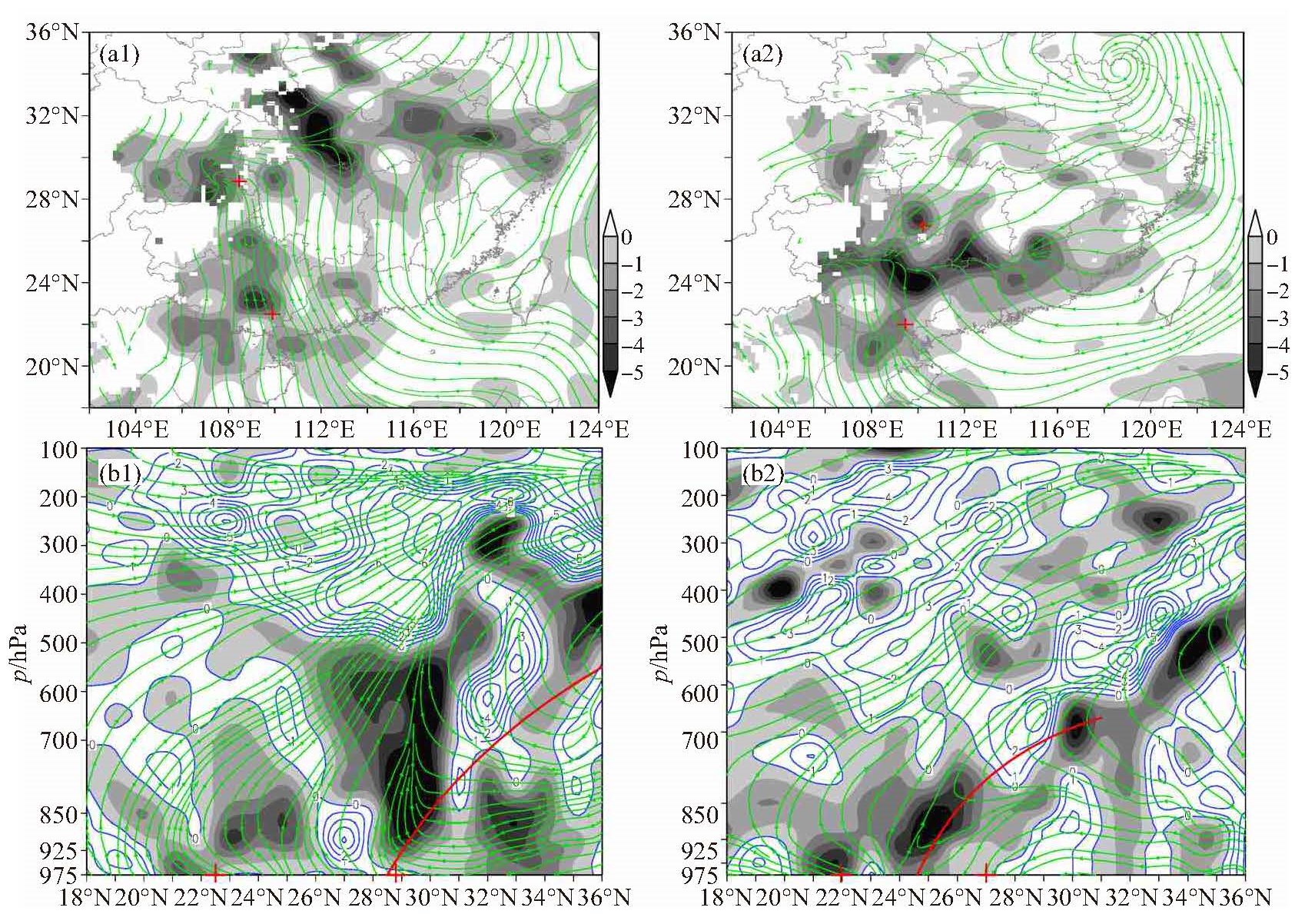
图 6 两次过程的散度(阴影为负值,蓝色等值线为正值,单位:10-5s-1)和流场的925 hPa分布(a1、a2)及穿过暖区暴雨中心的垂直剖面(b1、b2)
a1、b1. 2013年4月29日08:00;a2、b2. 2014年4月6日02:00。红色粗实线表示北侧的锋面。

图 7 两次过程925 hPa相当位温θe的分布和沿AB线的垂直剖面
a1、b1. 2013年4月29日02:00;a2、b2. 2014年4月6日02:00。红色实线表示锋面,绿框为弱不稳定或湿中性层结,蓝框为对流不稳定区。单位: K。

图 8 两次过程温度平流的演变
单位:10-5 K/s,等值线间隔:2×10-5 K/s。a1. 2013年4月28日20:00 1 000 hPa;a2. 2014年4月5日20:00 1 000 hPa;b1. 2013年4月29日02:00 925 hPa;b2. 2014年4月6日02:00 925 hPa;c1. 2013年4月29日08:00 925 hPa;c2. 2014年4月6日08:00 925 hPa。
-
[1] 黄士松, 李真光, 包澄澜, 等.华南前汛期暴雨[M].广州:广东科技出版社, 1986:94-95. [2] 林晓霞, 冯业荣, 张诚忠, 等.华南一次暴雨过程热力和动力特征的诊断分析[J].热带气象学报, 2017, 33(6):975-984. [3] 赵玉春, 李泽椿, 肖子牛.华南锋面与暖区暴雨个例对比分析[J].气象科技, 2008, 36(1):47-54. [4] 张晓惠, 倪允琪.华南前汛期锋面对流系统与暖区对流系统的个例分析与对比研究[J].气象学报, 2009, 67(1):108-121. [5] 丁治英, 朱莉, 常越, 等.一次连续性暴雨中双雨带的成因分析[J].热带气象学报, 2009, 25(6):697-705. [6] 罗娟, 冯家兄, 陈沐希.中尺度对流系统内β尺度双雨带不稳定机制及锋生对比分析[J].干旱气象, 2018, 36(3):456-464. [7] 王华, 李宏宇, 仲跻芹, 等.京津冀一次罕见的双雨带暴雨过程成因分析[J].高原气象, 2019, 38(4):856-871. [8] 林宝亭, 陆秋霖, 林确略, 等.一次玉林地区漏报的强双雨带影响的过程分析[J].气象, 2020, 46(3):313-324. [9] 张艳霞, 蒙伟光, 徐道生, 等.华南锋面和季风降水环流特征及加热结构对比分析[J].热带气象学报, 2020, 36(1):1-12. [10] 苗春生, 杨艺亚, 王坚红, 等.两类华南沿海暖区暴雨特征及热力发展机制对比研究[J].热带气象学报, 2017, 33(1):53-63. [11] 林良勋.广东省天气预报技术手册[M].北京:气象出版社, 2006:119-150. [12] 《广西天气预报技术和方法》编写组.广西天气预报技术和方法[M].北京:气象出版社, 2012:46-48. [13] 何立富, 陈涛, 孔期.华南暖区暴雨研究进展[J].应用气象学报, 2016, 27(5):559-569. [14] 叶朗明, 徐碧裕, 周荣斌.两次不同类型暖区暴雨的对比分析[C]//第33届中国气象学会年会S1灾害天气监测、分析与预报, 2016: 1 806-1 817. [15] 赵玉春, 王叶红.近30年华南前汛期暴雨研究概述[J].暴雨灾害, 2009, 28(3):193-202, 228. [16] 谌芸, 陈涛, 汪玲瑶, 等.中国暖区暴雨的研究进展[J].暴雨灾害, 2019, 38(5):483-493. [17] 叶朗明, 苗峻峰.华南一次典型回流暖区暴雨过程的中尺度分析[J].暴雨灾害, 2014, 33(4):342-350. [18] 张亚妮, 姚秀萍, 于超.高层动力强迫对回流型华南暖区暴雨影响的个例研究[J].热带气象学报, 2019, 35(2):166-176. [19] 张晓美, 蒙伟光, 张艳霞, 等.华南暖区暴雨中尺度对流系统的分析[J].热带气象学报, 2009, 25(5):551-560. [20] 林确略, 寿绍文, 杨华.基于数值模拟对一次广西前汛期回流暴雨形成机制的分析[J].气象, 2015, 41(7):852-862. [21] 曾智琳, 谌芸, 朱克云. 2017年"5.7"广州特大暴雨的中尺度特征分析与成因初探[J].热带气象学报, 2018, 34(6):791-805. [22] 叶朗明, 郑伟杰, 徐碧裕. 2014年"5. 8"广东大暴雨中尺度特征分析[J].广东气象, 2014, 36(6):11-15. [23] 于鑫, 郑腾飞, 黄健, 等.一次华南海岸带暖区暴雨过程的观测分析[J].热带气象学报, 2017, 33(1):134-144. [24] 陈翔翔, 丁治英, 刘彩虹, 等. 2000—2009年5、6月华南暖区暴雨形成系统统计分析[J].热带气象学报, 2012, 28(5):707-718. [25] 朱乾根, 林锦瑞, 寿绍文, 等.天气学原理和方法[M].北京:气象出版社, 2000:347-349. [26] 陆慧娟, 高守亭.螺旋度及螺旋度方程的讨论[J].气象学报, 2003, 61(6):684-691. -

 下载:
下载:


 点击查看大图

计量
- 文章访问数: 315
- HTML全文浏览量: 153
- PDF下载量: 97
- 被引次数: 0
 粤公网安备 4401069904700003号