


CASUAL ANALYSIS OF A SHORT-TERM HEAVY RAIN EVENT IN YUNNAN PROVINCE UNDER THE BACKGROUND OF WESTWARD MOVING TYPHOON
-
摘要: 利用云南省自动气象站雨量资料、卫星和闪电定位仪资料、雷达回波资料、NCEP 1 °×1 °再分析资料和地面、高空常规观测资料对云南一次典型的台风前侧短时强降水过程的成因进行分析,结果表明:在2017年13号台风“天鸽”西行影响云南的天气背景之下,短时强降水出现在台风前侧700 hPa风速辐合区和边界层辐合线附近。台风前侧偏东低空急流向云南境内输送水汽和能量,边界层辐合线触发垂直上升运动,700 hPa风速辐合区利于垂直上升运动的维持和加强,促使水汽的辐合与不稳定能量的释放,引发短时强降水。在中等强度深层垂直风切变的作用下,云南东部中尺度对流系统(MCS)频繁产生并向西传播发展,MCS相互作用组织成飑线系统,在东北气流的引导下,飑线从云南中部移至云南西南部,MCS和飑线是大范围短时强降水的直接影响系统。Abstract: In the present study, the cause of a typical short-term heavy rainfall event in front of a typhoon in Yunnan Province was analyzed by using precipitation data from automatic stations in Yunnan Province, satellite and lighting locator data, radar echo data and NCEP 1 °×1 ° reanalysis data. The results showed that under the influence of the westward movement of Typhoon Hato, the 13th typhoon in 2017, a short-term heavy rainfall occurred near the 700 hPa wind velocity convergence zone and the boundary layer convergence line in front of the typhoon. The easterly low-level jet stream in front of the typhoon transported water vapor and energy to Yunnan. The convergence line in the boundary layer triggered vertical upward movement. The convergence zone of 700 hPa wind velocity was conducive to the maintenance and development of vertical upward movement, which promoted the convergence of water vapor and the release of unstable energy and thus caused short-term heavy rainfall. Under the influence of moderate deep vertical wind shear, mesoscale convective systems (MCS) occurred frequently in the east part of Yunnan, and then propagated westward. The MCS interacted and formed the squall line system. Under the influence of the northeast airflow, the squall line moved from central Yunnan to southwest Yunnan. MCS and squall lines were the direct influence systems of large-scale short-term heavy rainfall.
-
Key words:
- westward moving typhoon /
- short-term heavy rainfall /
- squall line /
- conceptual model /
- Yunnan Province
-

图 2 云南省乡镇观测站短时强降水分布图
a. 2017年8月22日20时—23日08时;b. 2017年8月23日08—20时;c. 2017年8月23日20时—24日08时;d. 2017年8月24日08—20时。单位:mm。

图 4 昆明1.5 °仰角基本反射率因子图和速度图
a. 2017年8月23日12:28基本反射率因子图;b. 2017年8月23日14:02基本反射率因子图;c. 2017年8月23日12:28速度图;d. 2017年8月23日14:02速度图。

图 7 2017年8月23日08时(a)、23日14时(b)、23日20时(c)、24日02时(d)、24日14时(e)、25日08时(f)500 hPa高度场和700 hPa风场综合图

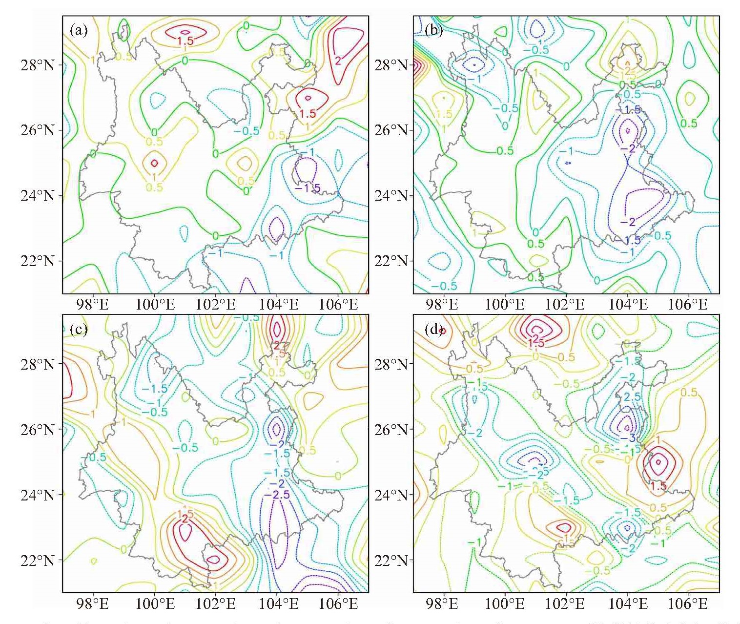
图 12 2017年8月22日20时(a)、23日08时(b)、23日14时(c)、23日20时(d)700 hPa低空急流(黑色实线,单位:m/s)、水汽通量(阴影,单位:g/(s·hPa·cm))及风矢量(风向标)综合图

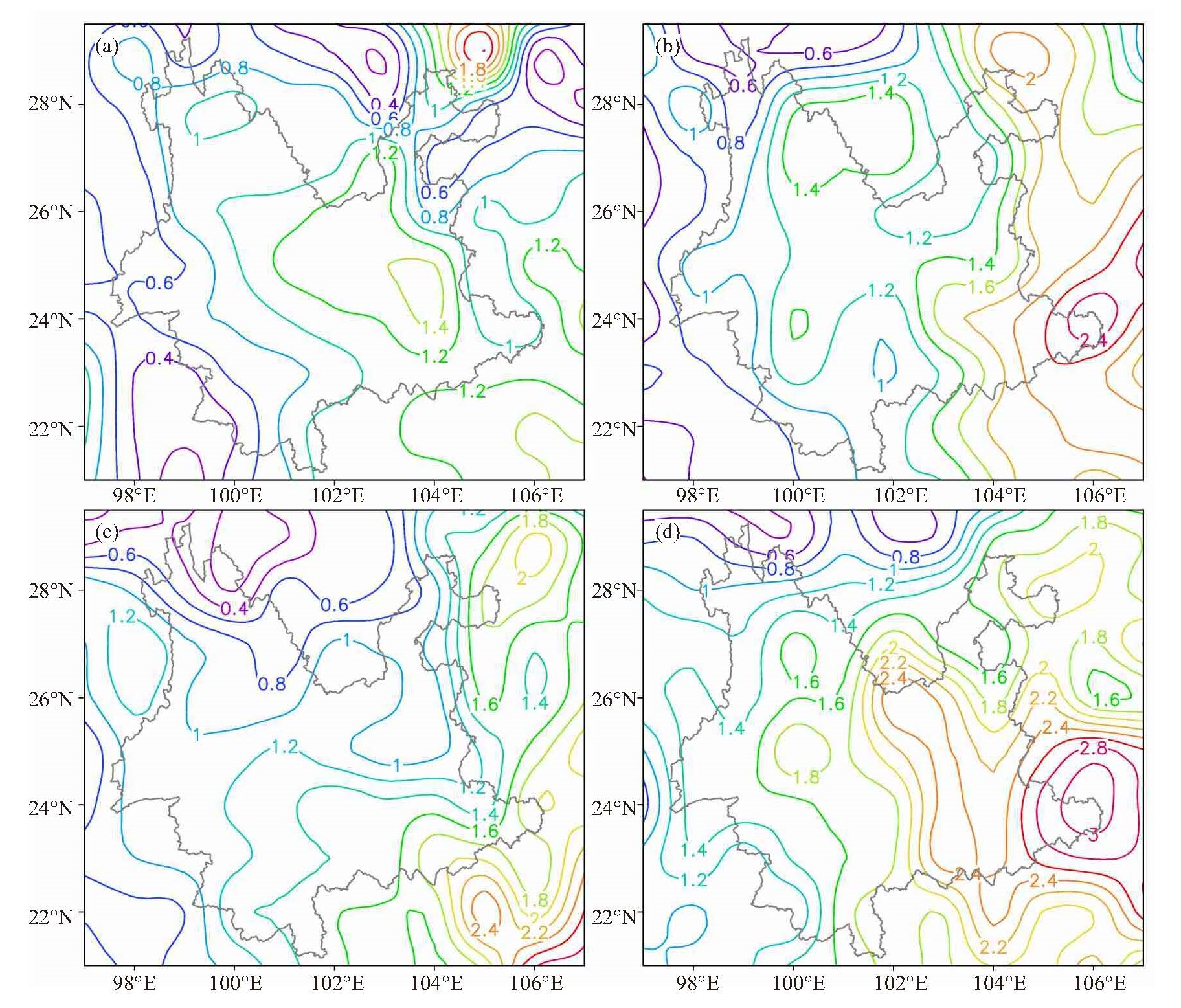
图 14 2017年8月22日20时(a)、23日08时(b)、23日14时(c)、23日20时(d)数值小于零的水汽通量散度(等值线和阴影,单位:10-5 g/(s·hPa·cm2))沿25 °N的纬向垂直剖面图
表 1 2012—2019年云南部分西行台风型短时强降水过程实况信息及天气形势配置
台风名称 登陆时间和地点 短时强降水过程发生时间 短时强降水区域 副高西脊点位置 700 hPa是否存在风速辐合区 是否存在边界层辐合线 韦森特 2012年7月24日4:15广东台山 7月22日08时—23日08时 滇东 115 °E 是 是 启德 2012年8月17日12:30广东湛江 8月15日08时—16日08时 滇中及以东以南 90 °E 是 是 飞燕(强热带风暴) 2013年8月2日19:30海南文昌 8月2日08时—3日08时 滇中及以东以南、滇西 90 °E 是 是 威马逊 2014年7月18日15:30海南文昌 7月17日08时—18日08时 滇中及以东以南、滇西 90 °E 是 是 海鸥 2014年9月16日9:40海南文昌 9月15日08时—16日08时 滇中大部、滇东局部 105 °E 是 是 妮妲 2016年8月2日3:35广东深圳 8月2日08时—3日08时 滇中及以东以南、滇西、滇东北北部 95 °E 是 是 天鸽 2017年8月23日12:50广东珠海 8月23日08时—24日08时 滇中及以东以南、滇西、滇东北 95 °E 是 是 山竹 2018年9月16日17:00广东台山 9月14日08时—15日08时 滇中、滇西南 92 °E 是 是 木恩 2019年7月3日00:45海南万宁 7月2日08时—4日08时 滇中及以东以南 105 °E 是 是  下载: 导出CSV
-
[1] 姜丽黎, 余晖.基于动力相似方法的台风极端降水概率预报研究[J].热带气象学报, 2019, 35(3):353-364. [2] 张诚忠, 薛纪善, 黄燕燕, 等.资料同化对2017年登陆广东沿海台风的短期降水与路径预报影响[J].热带气象学报, 2019, 35(5):577- 586. [3] 覃武, 赵金彪, 黄荣成, 等.台风"山竹"登陆结构变化及造成广西强降水异常分布的成因分析[J].热带气象学报, 2019, 35(5):587-595. [4] 李勋, 丁治英, 王勇.南海西行北翘路径热带气旋合成分析[J].热带气象学报, 2015, 31(3):444-456. [5] 徐舒扬, 周德丽, 苗绍慧, 等.台风"威马逊"造成云南强降水灾害天气分析[J].灾害学, 2016, 31(4):229-234. [6] 郭荣芬, 肖子牛, 李英.西行热带气旋影响云南降水的统计特征[J].热带气象学报, 2010, 26(6):680-686. [7] 钟爱华, 周泓, 赵付竹, 等.两次西行热带气旋影响云南的诊断分析[J].气象, 2015, 41(4):409-419. [8] 杨竹云, 杞明辉, 杨素雨, 等.台风"启德"影响云南强降水过程分析[J].云南大学学报(自然科学版), 2014, 36(S1):70-76. [9] 梁红丽, 程正泉. 2014年两次相似路径影响云南台风降水差异成因分析[J].气象, 2017, 43(11):1 339-1 353. [10] 孙继松, 戴建华, 何立富, 等.强对流天气预报的基本原理与技术方法[M].北京:气象出版社, 2014:1-2. [11] 何钰, 陈小华, 杨素雨, 等.基于"配料法"的云南短时强降水预报概念模型建立[J].气象, 2018, 44(12):1542-1554. [12] 李华宏, 王曼, 闵颖, 等.昆明市雨季短时强降水特征分析及预报研究[J].云南大学学报(自然科学版), 2019, 41(3):518-525. [13] 冯德花, 李华宏, 牛法宝, 等. MJO背景下云南省3次台风强对流天气对比分析[J].云南大学学报(自然科学版), 2019, 41(1):105-115. [14] 寿绍文, 励申申, 姚秀萍.中尺度气象学[M].北京:气象出版社, 2003:177-191. [15] 孙继松, 戴建华, 何立富, 等.强对流天气预报的基本原理与技术方法[M].北京:气象出版社, 2014:50-93. [16] 刘建文, 郭虎, 李耀东, 等.天气分析预报物理量计算基础[M].北京:气象出版社, 2005:117-118. -


 点击查看大图

计量
- 文章访问数: 406
- HTML全文浏览量: 93
- PDF下载量: 58
- 被引次数: 0
 粤公网安备 4401069904700003号