


ANALYSIS OF THE CAUSE OF TORRENTIAL RAIN ON MAY 18, 2019 IN SHAOGUAN
-
摘要: 2019年5月18日,广东省韶关市出现了局地特大暴雨,刷新了韶关有气象记录以来的雨量记录。利用常规观测资料、区域气象自动站观测资料、韶关双偏振多普勒天气雷达资料,以及NCEP 1 °×1 °再分析资料对本次过程进行详细分析,探讨本次过程发生的极端性成因。(1) 本次过程是粤北历史罕见的局地暖区突发性特大暴雨过程,天气尺度的背景场较弱,极端性条件不显著,但能从中尺度分析场分析出暴雨潜势。(2) 暴雨发生之前,韶关一直处于偏南暖湿气流控制的区域,并且随着对流抑制减小为0,对流有效位能增强,自由对流高度下降至近地面,使得气块更容易被强迫抬升。(3) 多个单体持续发展与合并,出现“列车效应”,近地面冷池维持向南楔入,低层西南风加强叠加于冷池上导致强风速辐合辐散区和中气旋的出现,是维持强回波持续发展的重要原因;回波呈暖区降水的垂直结构特性,也呈现出近地面层冷池对暖湿气流强迫抬升的结构特征,侧面说明了强降水触发机制。(4) 地形对对流触发和暴雨的增幅有重要影响,峡谷和喇叭口地形加强了偏南气流的汇入及辐合作用,山前迎风坡除了地形抬升作用外,位于山前的地面辐合线对于对流既有触发又有加强与维持的作用。(5) 山前强水平温度梯度为对流发生提供了有利的环境条件,当初生对流出现降雨之后,水平温度梯度进一步加强,形成了温度梯度与对流强度之间的正反馈过程,因而对流持续发展与维持。(6) 对于此类突发的短历时强降水造成的暖区暴雨,监测和短临预警仍然是主要手段。Abstract: On May 18, 2019, there was a severe local rainstorm in Shaoguan, setting a new rainfall record since Shaoguan had meteorological records. In the present study, a detailed analysis of the process is carried out by using conventional observational data, regional meteorological automatic station observational data, Shaoguan dual-polarization doppler weather radar data, and NCEP 1 °×1 ° reanalysis data, so as to explore the reason why this rainstorm is so extreme and its predictability. The results are as follows. (1) This is a severe warm-sector torrential rain, which is rarely seen in northern Guangdong Province. The background field of weather scale is weak, and the extreme conditions are not significant.However, the potential of the rainstorm can be analyzed from the mesoscale analysis field. (2) Before the rainstorm, Shaoguan was in the area controlled by the warm and humid airflow from the south. With the decrease of the convective inhibition to 0, the convective effective potential energy is enhanced, and the free convective height drops to near the ground. (3) The strong superposition of the low-level southwesterly wind on the cold pool leads to the appearance of strong wind speed convergence and divergence zones and medium cyclones, which is an important reason for maintaining the continuous development of strong echoes. The echo shows the vertical structure characteristics of warm-sector precipitation, and presents the structural characteristic of cold pool in the near ground layer that forces the warm and wet airflow upward, which explains the triggering mechanism of heavy precipitation. (4) The terrain has an important influence on the triggering of convection and the increase of heavy rain. The canyon and trumpet-shaped topography strengthens the convergence of southerly airflow. Besides the topographic uplift, the convergence line on the ground in front of the mountain not only triggers but also maintains and strengthens the convection. (5) The strong horizontal temperature gradient in front of the mountain provides favorable environmental conditions for the occurrence of convection. After the initial rainfall of the convection, the horizontal temperature gradient is further strengthened, forming a positive feedback process between the temperature gradient and the convective intensity, so that the convection continues to develop and maintain. (6) Monitoring and short-term early warning are still the main means for such sudden short-duration warm-sector torrential rains.
-

图 2 基于MICAPS资料得到的2019年5月17日20时天气尺度背景
图中方框为韶关区域。a. 500 hPa位势高度图(等值线单位:dagpm)和风场;b. 200 hPa流场(填色单位:m/s)。

图 6 2019年5月18日韶关雷达1.5 °的01:24(a)、02:36(b)、03:36(c)的基本反射率因子和1.5 °的02:00(d)、03:36(e)、04:06(f)的径向速度

图 7 2019年5月18日韶关雷达1.5 °的05:42(a)、06:00(b)、07:00(c)的反射率因子和1.5 °的05:42(d)、06:00(e)、06:30(f)的径向速度(红色圆框为中气旋)

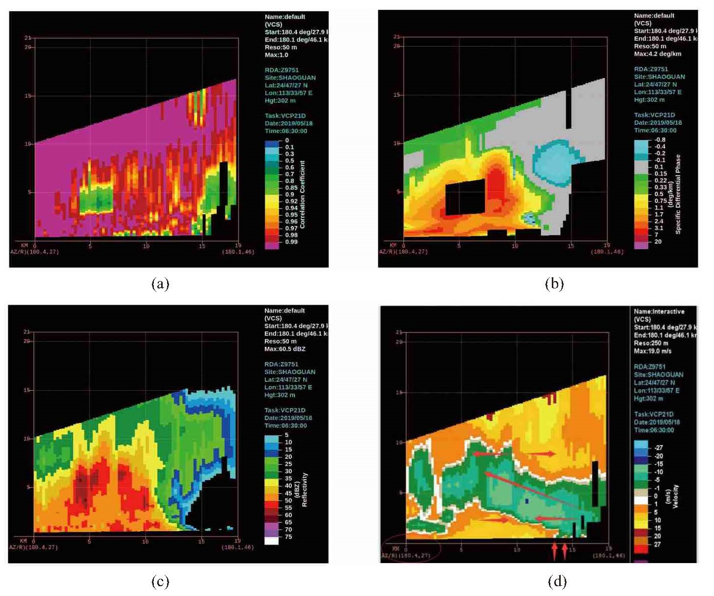
图 8 2019年5月18日06:30沿180.4 ° 27~46 km的反射率(a)、径向速度(b)、协相关系数(c)和差分相移率(d)的垂直剖面图
d图中Kdp红色部分中的黑色方框是c图中相应区域小于0.9,Kdp被认为数据不可靠而不再显示。

图 10 a. 韶关与清远英德的地形图(单位:m,A为02时初生对流位置,B和C为03—06时强降水发生位置,圆圈为峡谷地形,方框为喇叭口地形);b. 18日03时韶关与清远英德气温分布(填色,单位:℃)和自动站10 m风场(虚线为地面辐合线);18日03时(c)和18日05时(d)韶关与清远英德订正气温距平分布(填色,单位:℃)和地面自动站10 m风场(虚线为地面辐合线)。

图 11 2019年5月18日03时(a)和05时(b)的GRAPES短临3 km预报模式2 m气温分析场(单位:℃)和10 m风场
虚线为地面辐合线,方框为图 10a所示的峡谷和喇叭口地形。
表 1 2019年5月17日20时和18日02时的清远和阳江探空站物理量
时间 站点 LFC/hPa LCL/hPa CAPE/(J/kg) CIN/(J/kg) K/℃ SI/℃ 17日20时 清远 668 994 1 025.1 180.4 43 -3.88 阳江 — — — — 39 -2.82 18日02时 清远 990 996 2 055.2 0 39 -1.12 阳江 — — — — 37 -3.06  下载: 导出CSV
-
[1] ALEXANDER L V, ZHANG X, PETERSON T C, et al. Global observed changes in daily climate extremes of temperature and precipitation[J]. J Geophys Res, 2006, 111(D5): D05109. [2] ALLEN M R, INGRAM W J. Constrains on future changes in climate and the hydrologic cycle[J]. Nature, 2002, 419(6 903): 224-232. [3] 朱乾根, 林锦瑞, 寿绍文, 等. 天气学原理和方法(第四版)[M]. 北京: 气象出版社, 2006: 321-323. [4] MADDOX R A, CHAPPELL C F, HOXIT L R. Synoptic and meso-α scale aspects of flash flood events[J]. Bull Amer Meteor Soc, 1979, 60(2): 115-123. [5] LAU K M, ZHOU Y P, WU H T. Have tropical cyclones been feeding more extreme rainfall[J]. J Geophys Res Atmos, 2008, 113(D23): D23113. [6] 陶诗言, 卫捷. 再论夏季西太平洋副热带高压的西伸北跳[J]. 应用气象学报, 2006, 17(5): 513-525. [7] 朱乾根, 林锦瑞, 寿绍文, 等. 天气学原理和方法(第四版)[M]. 北京: 气象出版社, 2006: 550. [8] 刘国忠, 丁治英, 贾显锋, 等. 影响华南地区西南低涡及致洪低涡活动的统计研究[J]. 气象, 2007, 33(1): 45-50. [9] 伍志方, 曾沁, 吴乃庚, 等. 广州"5.7"高空槽后和"5.14"槽前大暴雨过程对比分析[J]. 气象, 2011, 37(7): 838-846. [10] ZHANG D L, LIN Y H, ZHAO P, et al. The Beijing extreme rainfall of 21 July 2012: "Right results"but for wrong reasons[J]. Geophys Res Lett, 2013, 40(7): 1 426-1 431. [11] 陈碧莹, 闵锦忠. 华北"7•19"暴雨中低涡系统演变及多尺度相互作用机制研究[J]. 热带气象学报, 2020, 36(1): 85-96. [12] LUO Y L, WU M W, REN F M, et al. Synoptic situations of extreme hourly precipitation over China[J]. J Climate, 2016, 29(24): 8 703-8 719. [13] 黄士松. 华南前汛期暴雨[M]. 广州: 广东科技出版社, 1986: 244. [14] 林良勋, 冯业荣, 黄忠, 等. 广东省天气预报技术手册[M]. 北京: 气象出版社, 2006: 143-452、118. [15] 何立富, 陈涛, 孔期. 华南暖区暴雨研究进展[J]. 应用气象学报, 2016, 27(5): 559-569. [16] 钱维宏, 艾阳, 陈绿文, 等. 一次广东典型龙舟水暴雨过程的扰动形势分析[J]. 热带气象学报, 2020, 36(4): 433-443. [17] 丁治英, 刘彩虹, 沈新勇. 2005—2008年5、6月华南暖区暴雨与高、低空急流和南亚高压关系的统计分析[J]. 热带气象学报, 2011, 27(3): 307-316. [18] 孙继松, 雷蕾, 于波, 等. 近10年北京地区极端暴雨时间的基本特征[J]. 气象学报, 2015, 73(4): 609-623. [19] 孙军, 谌芸, 杨舒楠, 等. 北京721特大暴雨极端性分析及思考(二)极端性降水成因初探及思考[J]. 气象, 2012, 44(4): 469-484. [20] 王晓芳, 赖安伟, 王志斌. 一个长生命期准静止中尺度对流系统的观测特征及其持续的环境条件[J]. 大气科学, 2014, 38(3): 421-437. [21] 俞小鼎. 2012年7月21日北京特大暴雨成因分析[J]. 气象, 2012, 38(11): 1 313-1 329. [22] 杜青文, 任荣彩, 康锡言. "96.8"河北特大暴雨地面中尺度系统分析[J]. 气象, 1999, 25(7): 25-28. [23] 谌芸, 孙军, 徐珺, 等. 北京721特大暴雨极端性分析及思考(一)观测分析及思考[J]. 气象, 2012, 38(10): 1 255-1 266. [24] 伍志方, 蔡景就, 林良勋, 等. 2017年广州"5·7"暖区特大暴雨的中尺度系统和可预报性[J]. 气象, 2018, 44(4): 485-499. [25] BRINGI V N, CHANDRASEKAR V. 偏振多普勒雷达原理和应用[M]. 北京: 气象出版社, 2010: 264-270. [26] 曾智琳, 谌芸, 朱克云, 等. 2017年"5.7"广州特大暴雨的中尺度特征分析与成因初探[J]. 热带气象学报, 2018, 34(5): 791-805. [27] 傅佩玲, 胡东明, 张羽, 等. 2017年5月7日广州特大暴雨微物理特征及其触发维持机制分析[J]. 气象, 2018, 44(4): 500-510. [28] 孙继松, 杨波. 地形与城市环流共同作用下的β中尺度暴雨[J]. 大气科学, 2008, 32(6): 1 352-1 364. [29] 孙继松. 城市精细天气预报的理论与技术研究进展[J]. 气象科技进展, 2014, 4(1): 15-21. -


 点击查看大图

计量
- 文章访问数: 805
- HTML全文浏览量: 78
- PDF下载量: 64
- 被引次数: 0
 粤公网安备 4401069904700003号