


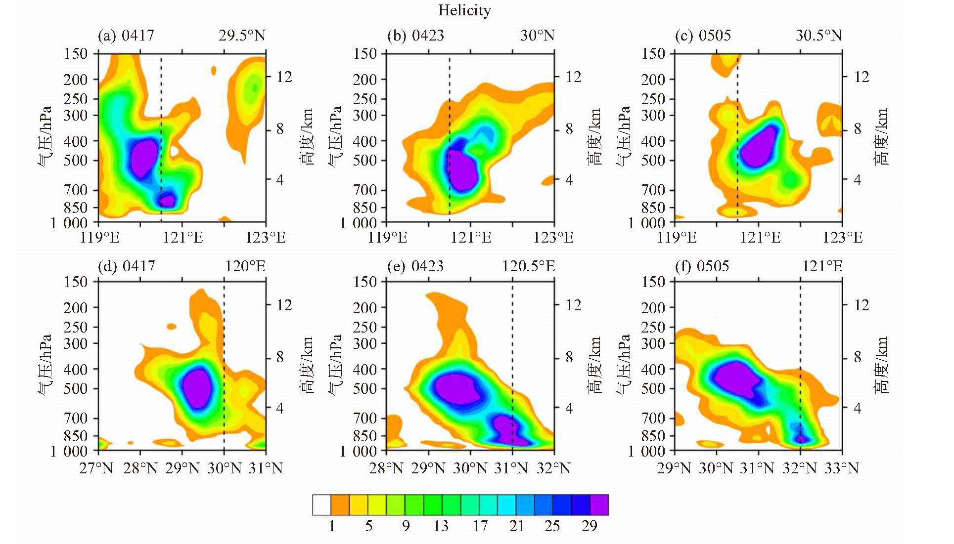
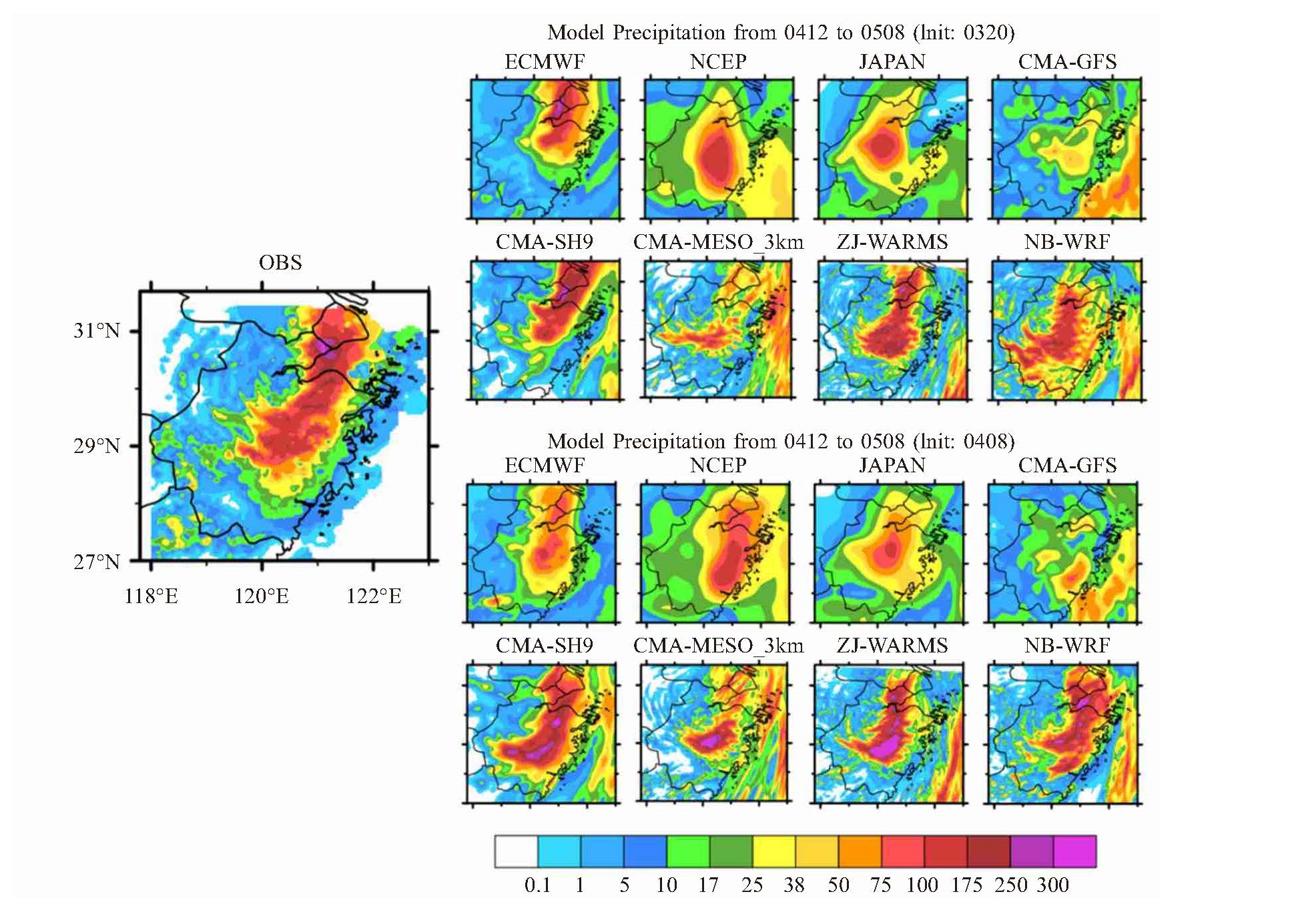
CAUSE ANALYSIS AND MULTI-MODEL FORECAST VERIFICATION OF RETARDED RAINSTORM RELATED WITH TYPHOON HAGUPIT IN NORTHEASTERN ZHEJIANG PROVINCE
-
摘要: 基于地面常规\加密观测及ERA5再分析、热带气旋最佳路径、雷达卫星等资料,利用天气诊断方法探讨了2020年4号台风“黑格比”在登陆北上减弱后南侧滞留的降水云团引发浙东北暴雨成因。受对流层中层副高西脊点偏西及台风北侧高层急流出口区右侧辐合下沉影响,台风云系不对称结构明显,主要分布在南侧。中层冷空气从台风西侧入侵触发中小尺度对流系统,小尺度云团在台风环流内逆时针移动至台风东侧并发展滞留,在浙东北引发强降水。期间冷暖气团(中层MPV1正值和低层MPV2负值)交汇区及中低层锋生大值均可指示暴雨落区,垂直螺旋度也可体现冷空气入侵后台风后倾的垂直结构演变特征;台风东侧持续的西南急流水汽输送有利于夜间浙东北对流降水的维持发展,且水汽低层辐散区对强降水落区有6 h左右的预报提前量。基于SAL定量降水检验证实:大尺度模式由于模拟对流降水演变的欠缺,无法预报出夜间滞后型暴雨增幅;中小尺度模式虽然对暴雨强度刻画相对准确,但大值雨区偏移;ECMWF 3日20:00起报场预报过程累积雨量误差小,较4日08:00起报预报结果更接近实况,但短时暴雨出现时间偏早3~6 h,不利于此类滞后型区域暴雨的预报参考。Abstract: Based on conventional observation data, intensive observation data, the optimal path of tropical cyclone from China Meteorological Administration, reanalysis fields from ERA5 and radar\ satellite data, the causes of rainstorm in Northeastern Zhejiang province triggered by the lingering raining cloud cluster in the south after typhoon Hagupit landed and weakened northward were analyzed by using weather diagnosis method. Affected by westward of west ridge point of the middle troposphere subtropical high and convergence sinking of right side of the upper jet stream exit area on the north of typhoon, the typhoon cloud system has obvious asymmetric structure, mainly distributed in the south side. The mesoscale convective systems were triggered by the middle troposphere cold air invaded from the west of typhoon and the small-scale cloud cluster moved counterclockwise to the east of typhoon and developed retention, causing heavy precipitation in Northeastern Zhejiang Province. During the rainstorm period, the intersection area of warm and cold air (the positive MPV1 in the middle troposphere and the negative MPV2 in the lower troposphere) and the frontogenesis great value area in the middle-lower troposphere can indicate the rainstorm area. The vertical helicity can also reflect the vertical structure evolution characteristics of typhoon backward-tilt after the cold air invasion. The continuous water vapor transport of the southwest jet on the east of typhoon was beneficial to the maintenance and development of convective precipitation in Northeastern Zhejiang Province at night and the water vapor divergence area can forecast the heavy precipitation area by leading about 6h. Based on the SAL quantitative precipitation verification, the large scale models cannot predict retarded rainstorm amplification at night due to the deficiency of simulated convective precipitation evolution; the meso-micro scale models described rainstorm intensity accurately, relatively, but the great value area deviated; the cumulative precipitation forecast by ECMWF (Initial: 20:00 on the 3rd) is slightly error, which is closer than that of 08:00 on the 4th, however, the shorttime rainstorm occurred 3—6 h earlier, which was bad for the forecast of such retained regional rainstorm.
-

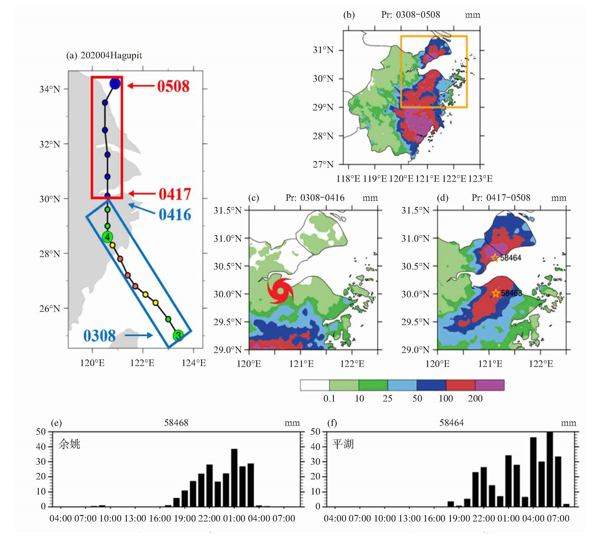
图 1 2020年第4号台风“黑格比”3日08:00至5日08:00路径(a,蓝红色方框分别为图c、d时段台风路径)和浙江过程雨量(b. 黄色方框表示浙东北区域),浙东北两个时段累积雨量分布(c. 3日08:00—4日16:00,红色台风标志为4日16:00台风中心位置;d. 4日17:00—5日08:00)和代表站点逐时雨量序列(e. 58468宁波余姚站;f. 58464嘉兴平湖站)

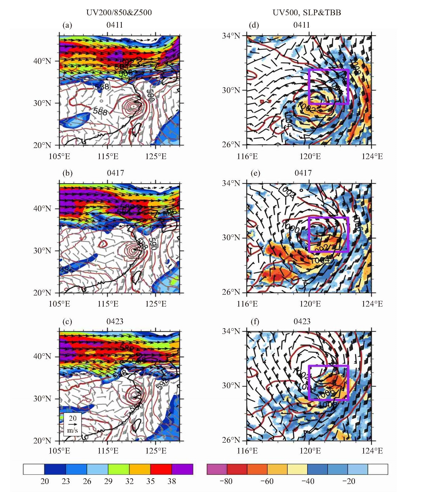
图 2 2020年8月4日11:00(a、d)、17:00(b、e)、23:00(c、f)500 hPa位势高度场(等值线,单位:10 gpm)、200 hPa风场(箭头,单位:m/s,阴影区风速大于20 m/s)、850 hPa风场(灰色风杆)(a、b、c)和海平面气压(等值线,单位:hPa),500 hPa风场(风杆,单位:m/s)及FY-2G TBB(阴影,单位:℃)(d、e、f)分布
紫色方框为浙东北区域。

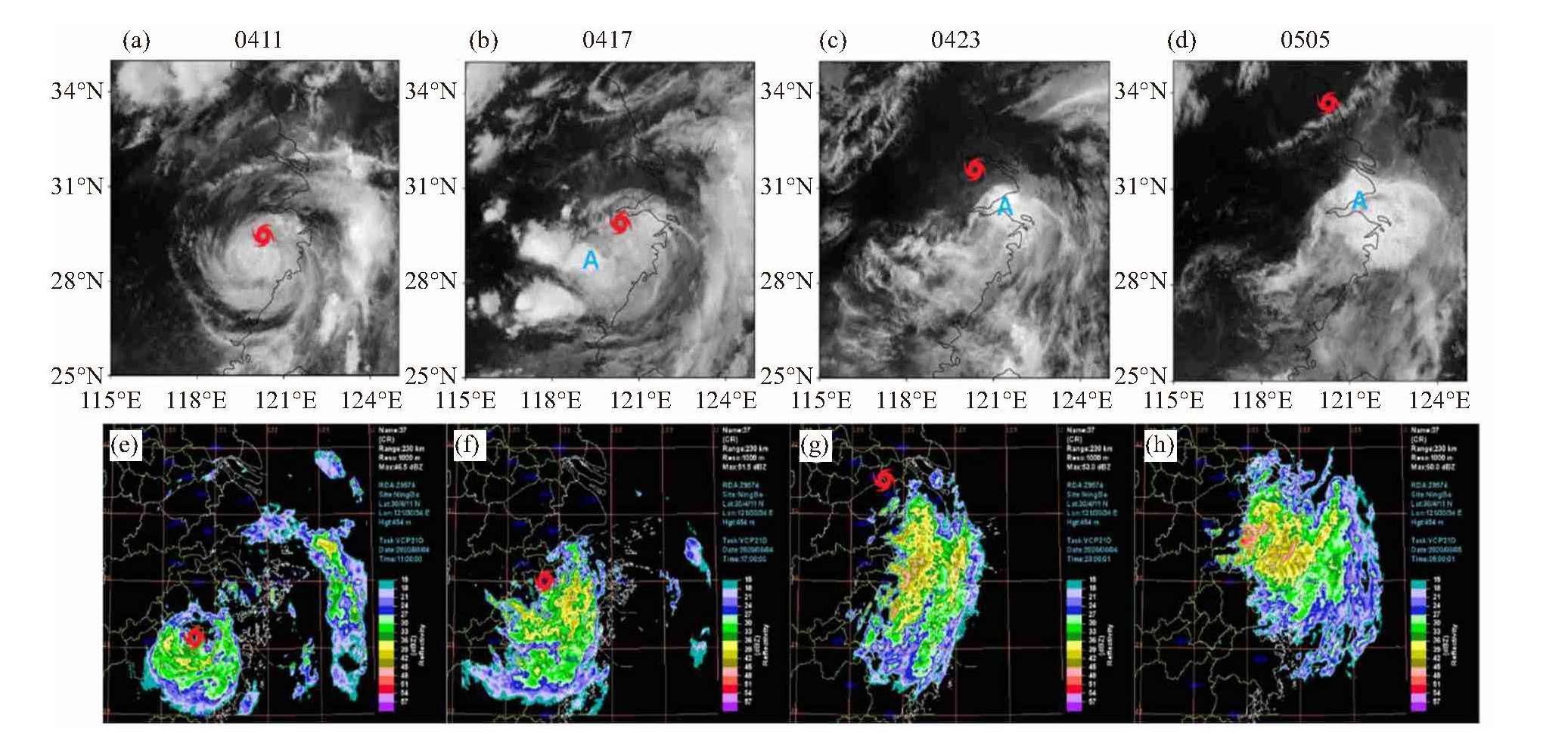
图 3 2020年8月4日11:00起逐6 h “葵花8”12 μm红外卫星云图(a~d)及宁波雷达(Z9574)37号产品组合反射率(e~h, CR, 15 dBZ以下的值已省略)
各时刻台风中心位置已用红色台风标识标出,云图中A为影响浙东北对流云团位置。

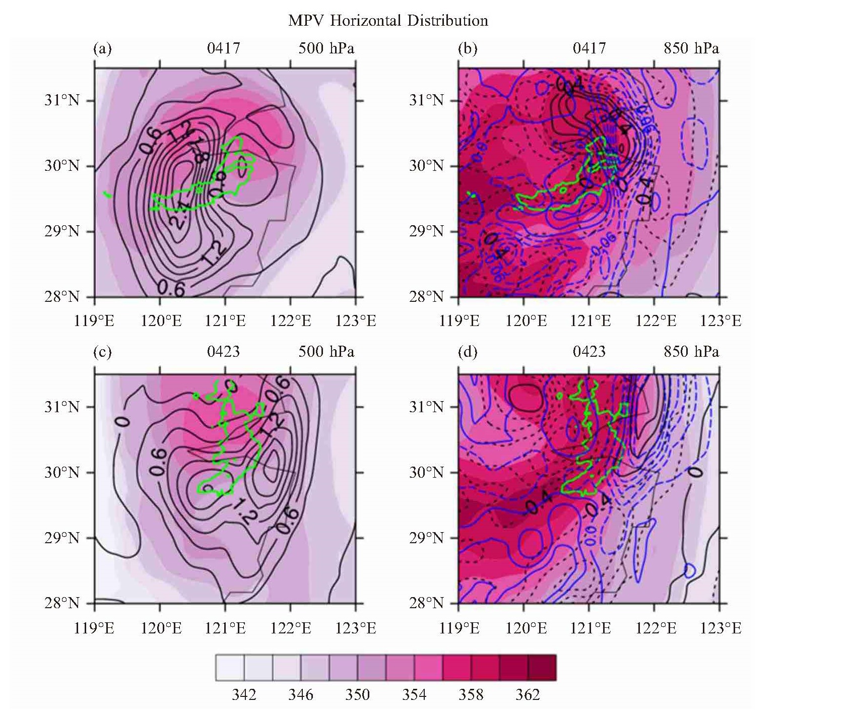
图 4 2020年8月4日17:00(a、b)和23:00(c、d)500 hPa(a、c)和850 hPa(b、d)假相当位温(阴影,单位:K)、MPV1 (黑色等值线,单位:PVU)、MPV2(蓝色等值线,单位:PVU,1PVU=10-6 K·m2/(s·kg))
绿色等值线代表未来3小时降水大于30 mm的区域。

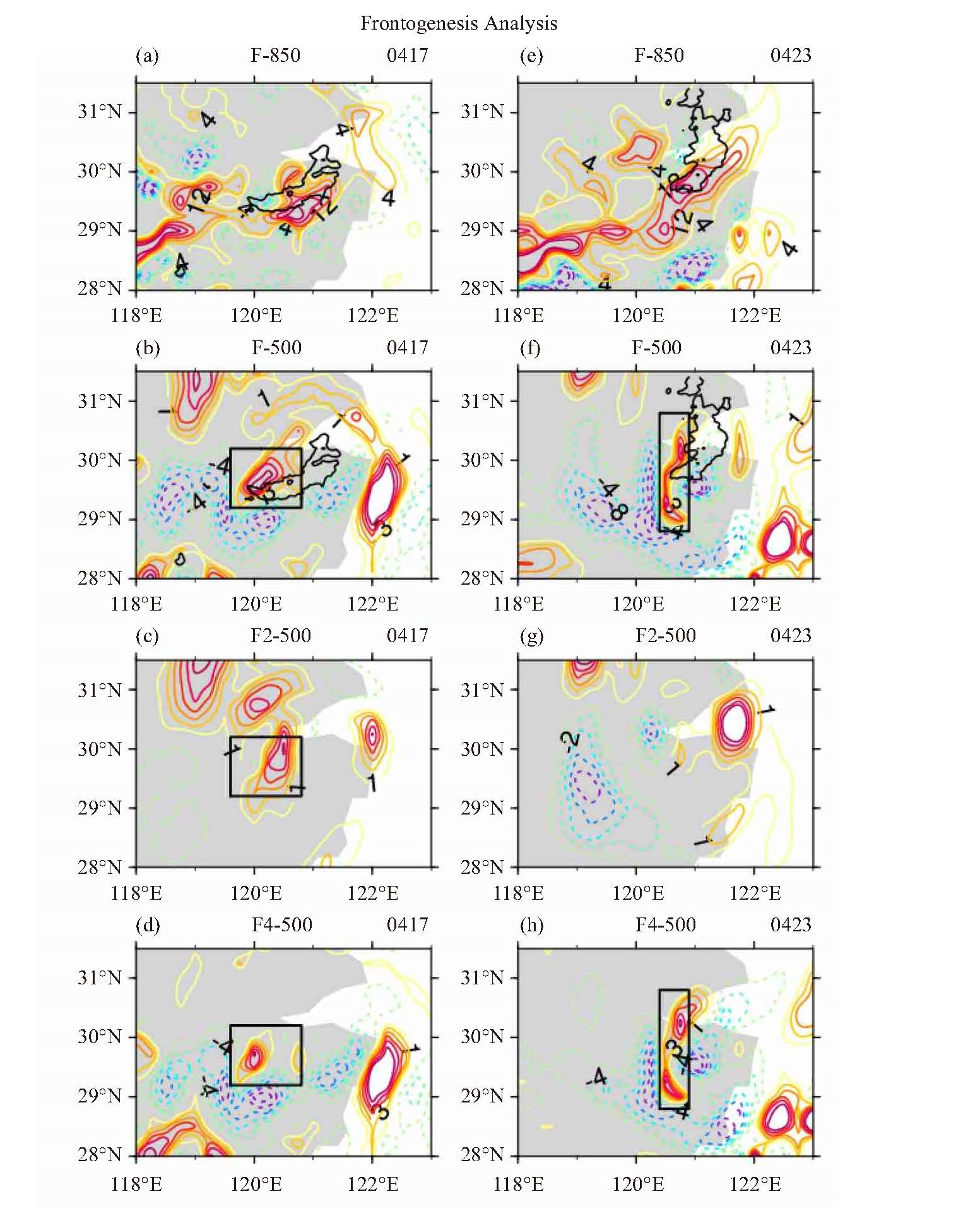
图 5 2020年8月4日17:00和23:00的500 hPa/850 hPa锋生函数(a、b、e、f)及水平辐散项(c、g)和垂直运动有关的倾斜项(d、h)
单位:10-10 K/(m·s)。黑色等值线为未来3 h降水量大于30 mm的区域。

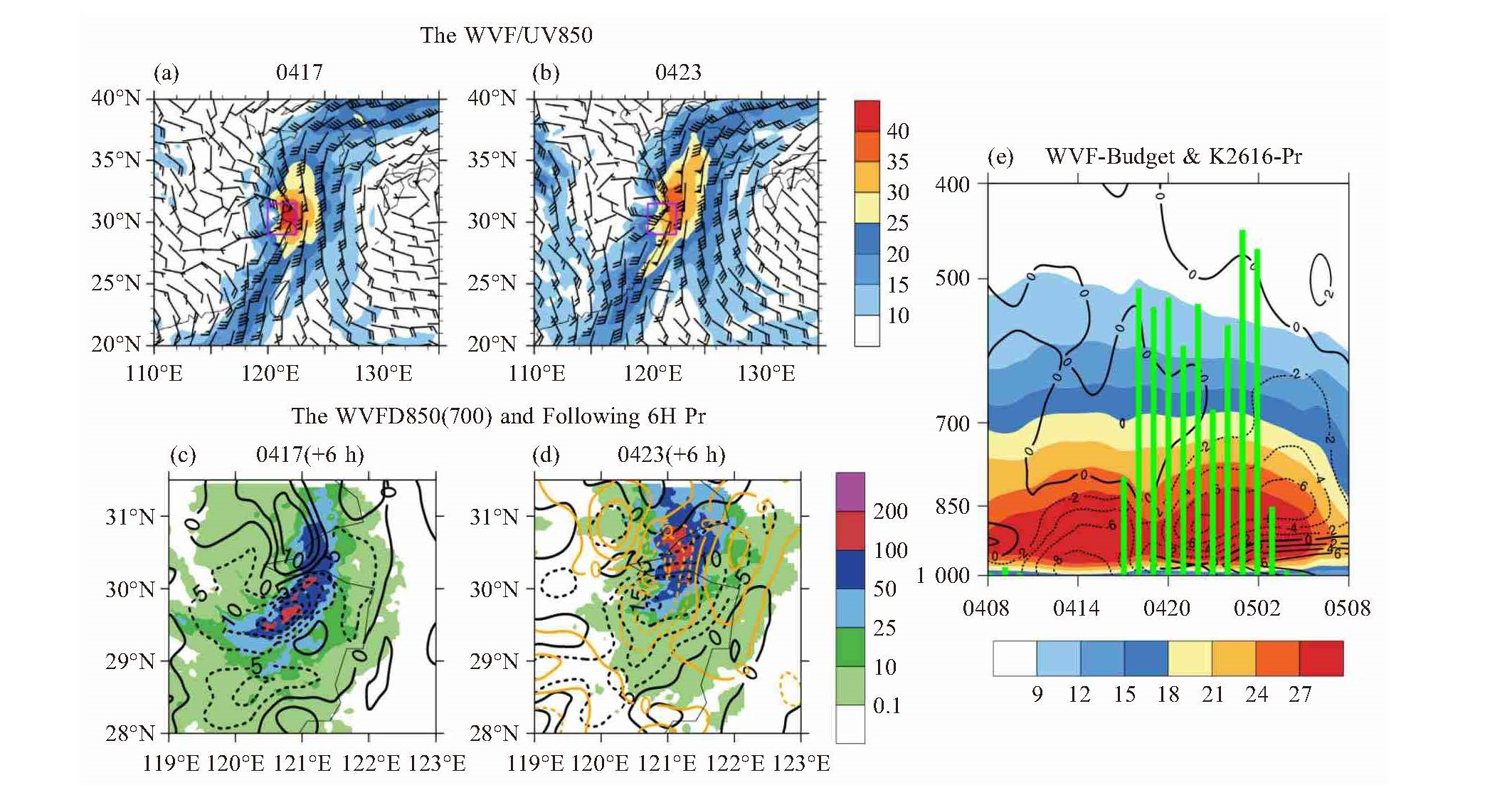
图 7 2020年8月4日17:00和23:00 850 hPa水汽通量(阴影,单位:g/(cm·hPa·s)、风场(风杆,单位:m/s)(a、b)和850 hPa (黑色等值线,单位:10-4 g/(hPa·cm·s)、700 hPa(橙色等值线)水汽通量散度、浙东北水汽通量(阴影)高度-时间剖面图(c、d)及余姚沈湾站逐时降水(e, 最大为30.8 mm/h)

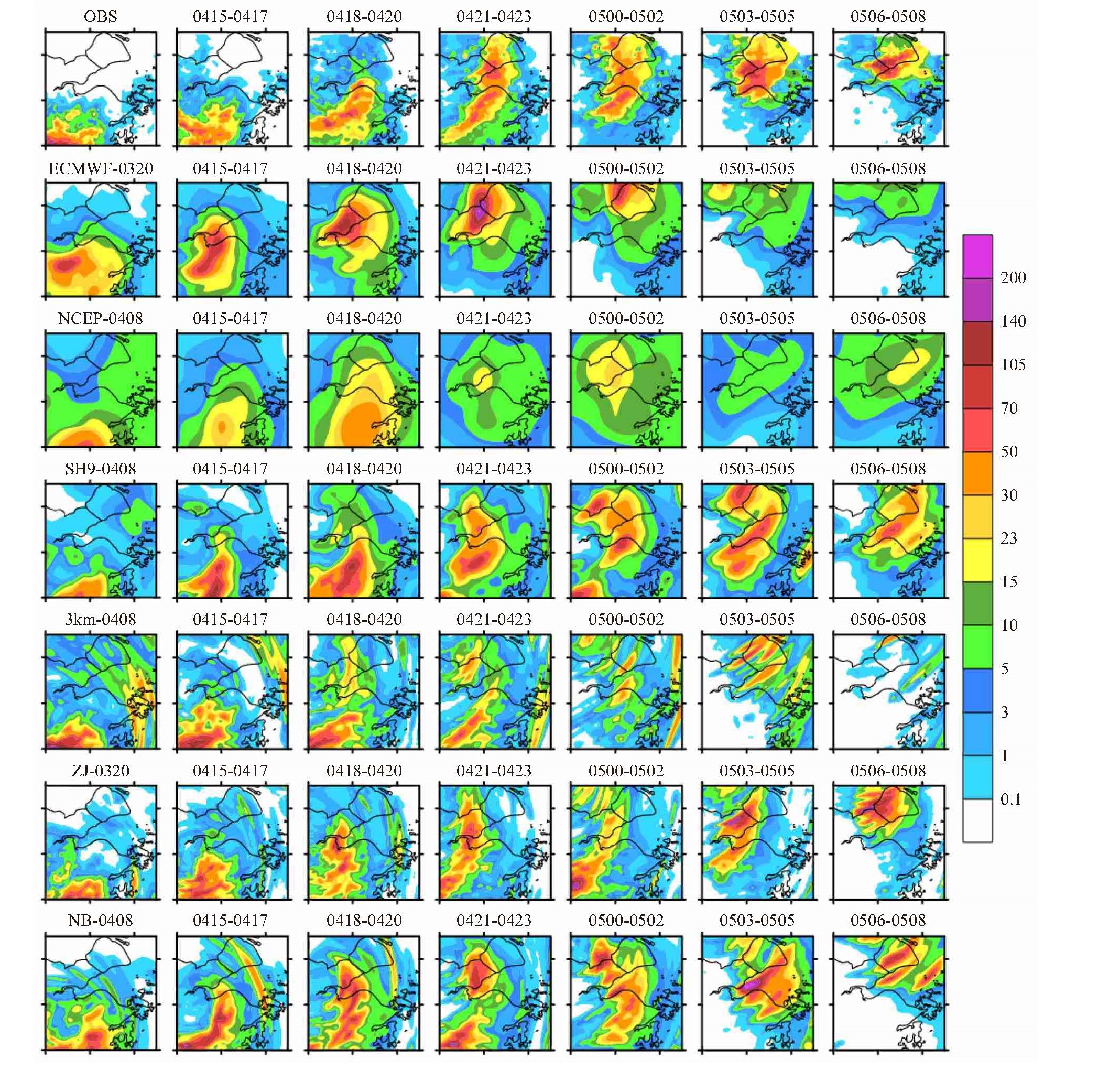
图 9 观测(第一行)及优选模式浙东北区域4日11:00—5日08:00逐3 h累积降水量空间分布演变(第1列为4日12:00—14:00 3小时累积降水量,第2列为4日15:00—17:00,以此类推;单位:mm)

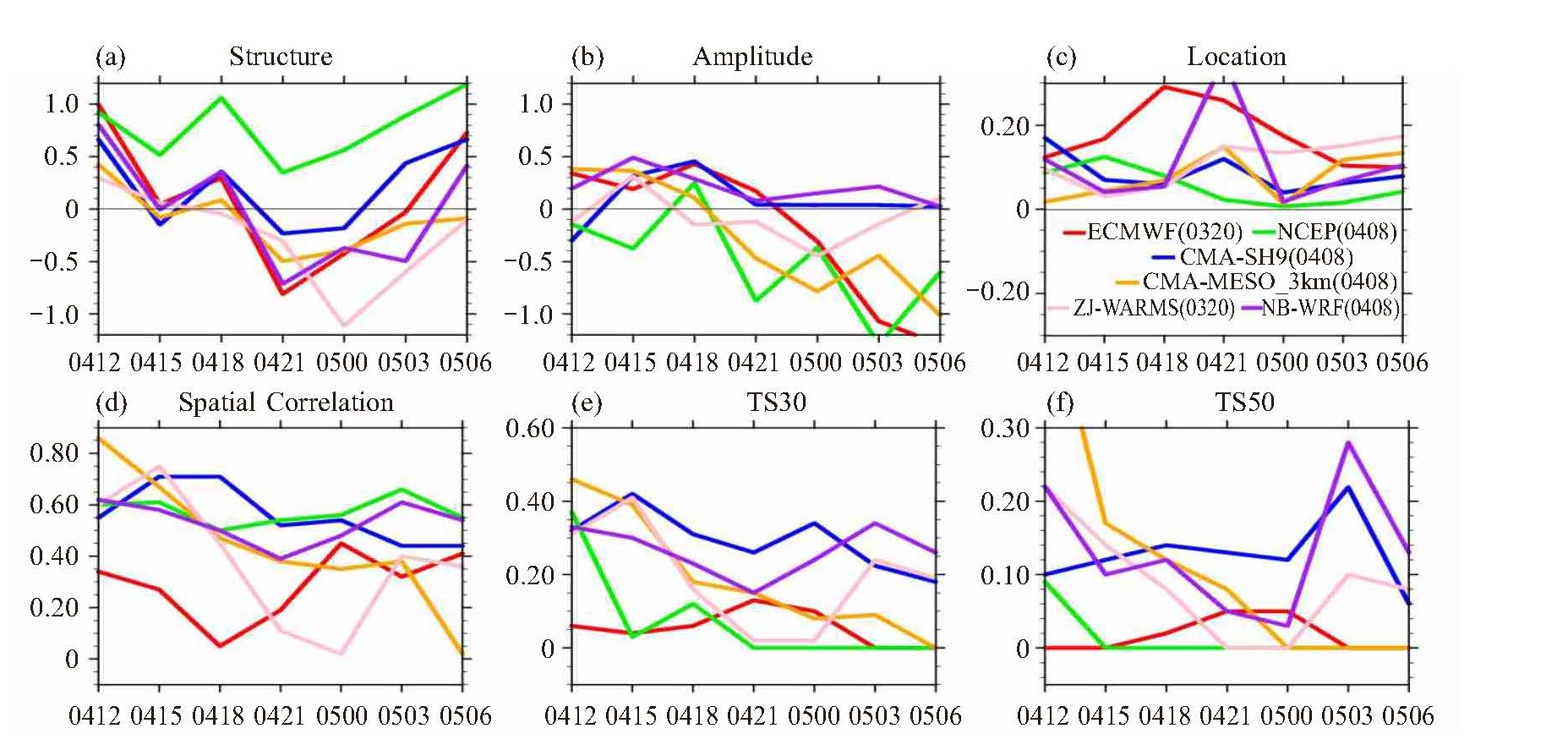
图 10 优选模式预报“黑格比”影响浙东北期间逐3 h降水量定量评估参数时序
a. SAL检验结构指标S;b. SAL检验强度指标A;c. SAL检验位置指标L;d. 空间相关系数;e. 30 mm强降水TS评分;f. 50 mm强降水TS评分。
表 1 多模式预报场时空参数
模式名 模式来源 预报时效 时间分辨率 水平分辨率 ECMWF 欧洲中期天气预报中心模式 240 h 3(72) h 0.125 °×0.125 ° NCEP 美国国家环境预报中心模式 360 h 3(84) h 0.5 °×0.5 ° JAPAN 日本气象厅中期预报模式 216 h 3(84) h 0.5 °×0.5 ° CMA-GFS 中国气象局全球天气预报系统 240 h 3(72) h 0.25 °×0.25 ° CMA-SH9 中国气象局华东区域上海9 km模式 72 h 1 h 0.1 °×0.1 ° CMA-MESO_3km 中国气象局中小尺度3 km模式 36(6) h 1 h 0.03 °×0.03 ° ZJ-WARMS 浙江省气象局中尺度模式 72 h 1 h 0.03125 °×0.03125 ° NB-WRF 宁波市气象局天气研究预报模式 60(6) h 3 h 0.0225 °×0.0225 °  下载: 导出CSV
表 2 浙东北区域优选模式过程累积降水量预报检验
Pr0412-0508 S A L TS50 TS100 Spa. Cor. RMSE ECMWF(0320) 0.057 0.004 0.076 0.63 0.29 0.52 57.3 ECMWF(0408) 0.568 -0.424 0.053 0.61 0.08 0.65 50.5 NCEP(0408) 0.712 -0.202 0.054 0.52 0.09 0.56 52.26 JAPAN(0408) 0.379 -0.565 0.093 0.36 0.07 0.43 58.3 CMA-SH9(0408) 0.188 0.232 0.023 0.69 0.53 0.75 49.95 CMA-MESO_3km(0408) -0.439 -0.184 0.056 0.48 0.29 0.43 63.96 ZJ-WARMS(0320) 0.095 0.032 0.092 0.55 0.32 0.46 65.35 NB-WRF(0408) 0.039 0.261 0.014 0.63 0.50 0.71 55.81 注:TS50、TS100均为值越大预报越优,对于相应量级强降水的把握更好;空间相关系数(Spa. Cor.)和均方根误差(RMSE)均反映预报降水空间结构,前者越高越优,后者越小偏差越小。
下载: 导出CSV
-
[1] 陈联寿, 许映龙. 中国台风特大暴雨综述[J]. 气象与环境科学, 2017, 40(1): 3-10. [2] BOSART L F, CARR F H. A case study of excessive rainfall centered around Wellsville[J]. Mon Wea Rev, 1978, 106: 348-362. [3] DIMEGO G J, BOSART L F. The transformation of tropical storm Agnes into an extratropical cyclone. Part I: The observed fields and vertical motion computations[J]. Mon Wea Rev, 1982, 110: 385-411. [4] DIMEGO G J, BOSART L F. The transformation of tropical storm Agnes into an extratropical cyclone. Part Ⅱ: Moisture, vorticity and kinetic energy budgets[J]. Mon Wea Rev, 1982, 110: 412-433. [5] 郭宇光, 钱燕珍, 方艳莹, 等. "杜鹃"登陆减弱后所致的宁波大暴雨成因分析[J]. 暴雨灾害, 2018, 37(4): 356-363. [6] 陈联寿, 丁一汇. 西太平洋台风概论[M]. 北京: 科学出版社, 1979. [7] 陶诗言. 中国之暴雨[M]. 北京: 科学出版社, 1980. [8] 陈久康, 丁治英. 高低空急流与台风环流耦合下的中尺度暴雨系统[J]. 应用气象学报, 2000, 11(3): 271-281. [9] 段晶晶, 钱燕珍, 姜嘉俊, 等. 台风"卡努"影响下浙江东北部暴雨增强成因[J]. 干旱气象, 2020, 38(5): 737-746. [10] 85-906-07课题组. 台风科学、业务试验和天气动力学理论的研究(第四分册)[M]. 北京: 气象出版社, 1996. [11] FRANKLIN C N, HOLLAND G J, MAY P T. Mechanisms for the generation of mesoscale vorticity features in tropical cyclone rainbands [J]. Mon Wea Rev, 2006, 134(10): 2 649-2 669. [12] 孙建华, 齐琳琳, 赵思雄. "9608"号台风登陆北上引发北方特大暴雨的中尺度对流系统研究[J]. 气象学报, 2006, 64(1): 57-71. [13] 李江南, 王安宇, 杨兆礼, 等. 台风暴雨的研究进展[J]. 热带气象学报, 2003, 19(S1): 152-159. [14] 王新敏, 粟晗. 多数值模式对台风暴雨过程预报的空间检验评估[J]. 气象, 46(6): 753-764. [15] 钟有亮, 陈静, 王静, 等. GRAPES区域集合预报系统对登陆台风预报的检验评估[J]. 热带气象学报, 2017, 33(6): 953-964. [16] 伍远康, 刘德辅. 浙江省登陆台风暴雨落区研究[J]. 水文, 2009, 29(2): 81-83. [17] 郑铮, 潘灵杰, 钱燕珍, 等. 台风"利奇马"造成浙江沿海极端强降水的演变特征[J]. 干旱气象, 2021, 39(2): 269-278. [18] 倪钟萍, 王鹏, 黄晓龙, 等. 台风"利奇马"与"云娜"对浙江风雨影响的对比分析[J]. 气象科学, 2021, 41(2): 172-182. [19] 王毅, 钱燕珍, 段晶晶, 等. "温比亚"台风登陆前后大暴雨特征及成因分析[J]. 海洋预报, 2020, 37(3): 62-71. [20] 陈联寿, 罗哲贤, 李英. 登陆热带气旋研究的进展[J]. 气象学报, 2004, 62(5): 541-549. [21] 董加斌, 黄新晴. 登陆浙江的台风路径分类和暴雨落区分析[J]. 浙江气象, 2019, 40(3): 13-19. [22] 胡潇杰, 俞宏耀, 於敏佳. 台风"黑格比"近海加强成因及对比分析[J]. 现代农业科技, 2021, 9: 187-190. [23] 刘松波. 2020年4号台风"黑格比"过程分析[J]. 黑龙江科学, 2021, 12(20): 36-40. [24] HEINI W, MARCUS P, MARTIN H, et al. SAL -a novel quality measure for the verification of quantitative precipitation forecasts[J]. Mon Wea Rev, 2008, 136: 4 470-4 487. [25] 吴国雄, 蔡雅萍, 唐晓. 湿位涡和倾斜涡度发展[J]. 气象学报, 1995, 53(4): 390-404. [26] 李耀辉, 寿绍文. 一次江淮暴雨的MPV及对称不稳定研究[J]. 气象科学, 2000, 20(2): 171-178. [27] 刘峰, 丁治英, 梁艳, 等. "莫拉克"台风暴雨过程中湿位涡场的演变特征[J]. 暴雨灾害, 2011, 30(2): 161-166. [28] 张雪蓉, 王丽芳, 王博妮, 等. 干冷空气对江苏热带低压倒槽大暴雨影响的数值试验[J]. 气象, 2021, 47(7): 791-804. [29] NINOMIYA K. Characteristics of BaiuFront as a predominant subtropical front in the summer northern hemisphere[J]. Journal of the Meteorological Society of Japan, 1984, 62(6): 880-894. [30] HOSKINS B J, BRET F P. Atmospheric frontogenesis model: mathematical formulation and solution[J]. Journal of Atmospheric Sciences, 1972, 29(1): 11-37. [31] 李耀东, 刘健文, 高守亭. 螺旋度在对流天气预报中的应用研究进展[J]. 气象科技, 2005, 33(1): 7-11. [32] 陈有利, 钱燕珍, 潘灵杰, 等. 一次与台风相关联的浙江东北部暴雨成因及预报难点分析[J]. 干旱气象, 2018, 36(2): 272-281. [33] 吴海英, 陈海山, 曾明剑, 等. 冷空气对台风"海葵"(1211)倒槽特大暴雨作用分析[J]. 热带气象学报, 2014, 30(5): 871-880. [34] 张树民, 王坤, 孙刚, 等. 台风尼伯特(1601)残留低压局地大暴雨成因分析[J]. 气象科技, 2018, 46(1): 139-148. [35] 于玉斌, 赵大军, 陈联寿. 干冷空气活动对超强台风"桑美"(2006)近海突然增强影响的数值模拟研究[J]. 热带气象学报, 2015, 31(1): 21-31. [36] 董美莹, 陈联寿, 郑沛群, 等. 登陆热带气旋暴雨突然增幅和特大暴雨之研究进展[J]. 热带气象学报, 2009, 25(4): 495-502. [37] 周福, 钱燕珍, 方艳莹, 等. "灿鸿"台风造成浙江东北部大暴雨成因分析[J]. 气象, 2016, 42(3): 305-313. -

 点击查看大图
计量
- 文章访问数: 435
- HTML全文浏览量: 116
- PDF下载量: 41
- 被引次数: 0
 粤公网安备 4401069904700003号