


MULTI-SCALE OBSERVATIONAL CHARACTERISTICS AND EVOLUTION OF THE 22 MAY 2020 EXTREME RAINFALL IN THE GUANGDONG-HONG KONG-MACAO GREATER BAY AREA
-
摘要: 2020年5月22日凌晨粤港澳大湾区发生了一次极端强降水过程,最大小时雨量和3小时雨量打破广东省内“龙舟水”期间的历史最高纪录。利用多源观测数据以及ERA5再分析资料对引发局地极端降水的中尺度对流系统(MCS)的演变过程与中尺度特征开展研究。(1) 此次强降水过程主要集中在凌晨时段,具有持续时间短、局地雨强极端、累积雨量大等特点,在3小时的降水过程中出现了两个降水峰值。(2) 这次过程为一次暖区暴雨过程,低层西南季风提供了充足的暖湿水汽,低涡切变线提供了良好的抬升条件。中α尺度季风云团呈准静止状态并升尺度增长为MCC(中尺度对流复合体)的过程引发了大湾区夜间局地的极端降水。(3) 过程中两个阶段的峰值降水与中γ尺度对流单体生消发展期间的传播与移动矢量发生的改变有密切联系。数个中γ尺度对流单体构成多单体风暴形态,呈西北-东南侧向排列,这些单体先后触发发展并有着各自的地面辐合线。对流单体在环境风引导下向偏东南方向移动引发第一阶段峰值降水。随后不同单体的辐合线连接,对流向西南方向传播显著加快,使对流系统移动矢量发生改变,因而造成第二阶段峰值降水。(4) 造成两段峰值降水的中γ尺度对流单体结构存在明显差异。第一阶段峰值降水的强回波延伸高度更高,具备倾斜、入流缺口和回波垂悬等类超级单体结构特征,第二阶段峰值降水回波则具有显著的热带对流低质心特征,造成了局地更极端的短历时强降水。Abstract: In the early morning of May 22, 2020, an extremely heavy rainfall process occurred in the Guangdong-Hong Kong-Macao Greater Bay Area. The maximum hourly and three-hour rainfall broke the historical record during the "Dragon Boat Water" period in Guangdong province. This paper uses multisource observation data and ERA5 reanalysis data to study the evolution process and mesoscale characteristics of the mesoscale convective system (MCS) causing the local extreme precipitation. The results are shown as follows. (1) The heavy precipitation process mainly concentrated in the early morning hours, with the characteristics of short duration, extreme local rainfall intensity, and large accumulated rainfall. Two precipitation peaks appeared in the three-hour precipitation process. (2) This process is a torrential rain process in the warm sector. A low-level southwest monsoon provides sufficient warm and humid water vapor, and a low vortex shear line provides good uplifting conditions. The process of meso-α-scale monsoon cloud clusters was quasi-stationary and grew by upscaling into MCC, triggering the local nighttime extreme precipitation in the Greater Bay Area. (3) Two stages of peak precipitation in the process is closely related to the propagation of meso-γ-scale convective cells in the life cycle and the change of the motion vector. Several meso-γ-scale convective cells form a multi-cell storm pattern, which is arranged in the northwest-southeast lateral direction. These cells are triggered to develop successively and have their own ground convergence lines. The first stage of peak precipitation is caused by the convective cell moving to the southeast under the guidance of the ambient wind. Subsequently, the convergence lines of different cells are connected, and the propagation of convection to the southwest is significantly accelerated, which changes the movement vector of the convective system, thus causing the peak precipitation in the second stage. (4) There are obvious differences in the structure of the meso-γ-scale convective cells that cause the two periods of peak precipitation. The strong echoes of the peak precipitation in the first stage have a higher extension height with supercell-like structural characteristics such as inclination, inflow gap, and echo overhang, and the echoes of the second stage of peak precipitation are characterized by convective, low mass cores, causing more extreme and localized shortduration heavy precipitation.
-

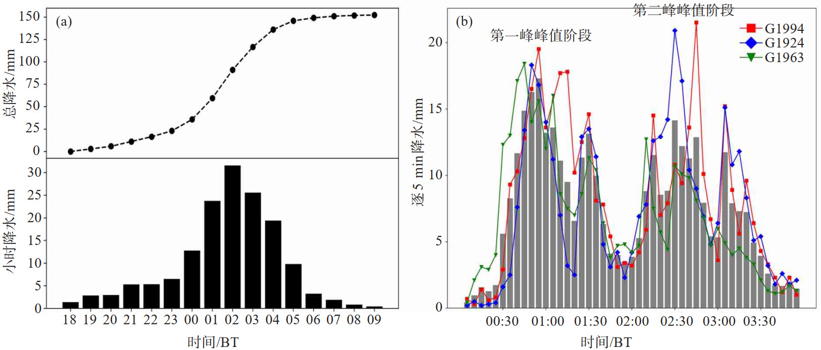
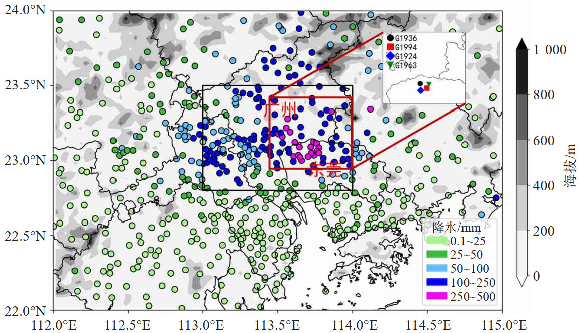
图 2 a. 2020年5月21日18时—22日09时研究区域(图 1黑方框)内地面自动站逐小时平均降水(单位:mm)和累积雨量变化(单位:mm);b. 该次过程累积降水量前三站点(G1994、G1924、G1963)5月22日00—04时逐5分钟雨量(单位:mm)

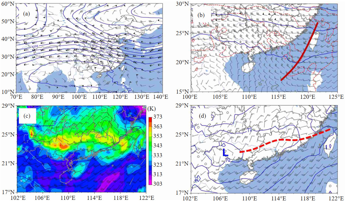
图 3 2020年5月21日20时200 hPa位势高度(单位:dagpm)、风场(风羽,单位:m/s)(a),500 hPa位势高度(单位:dagpm)、风场(风羽,单位:m/s)、温度场(红色虚线,单位:℃)(b),850 hPa风场(风羽,单位:m/s)、假相当位温(填色,单位:K)(c)及925 hPa位势高度(单位:dagpm)、风场(风羽,单位:m/s)(d)
蓝色等值线为等位势高度线(单位:dagpm),红色等值线为等温线(单位:℃),红色实线为短波槽,红色虚线为切变线。

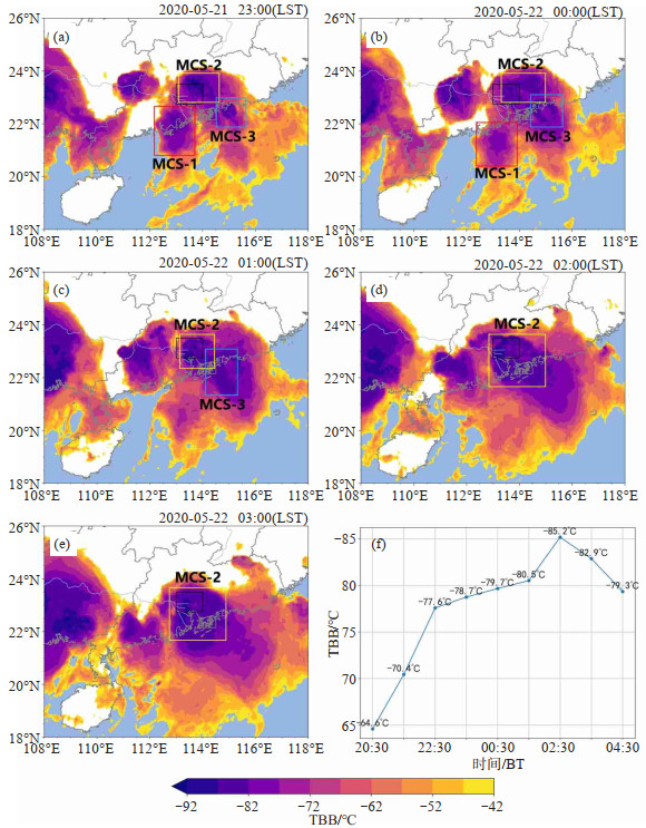
图 5 2020年5月21日23时—22日03时不同时刻葵花8号卫星观测的云顶亮温分布(a~e,彩色填图,单位:℃)及2020年5月21日20:30—22日04:30研究区域内云顶亮温平均值随时间的演变(f)
黑色方框为研究区域,红色方框内为MCS-1,黄色方框内为MCS-2,蓝色方框内为MCS-3。

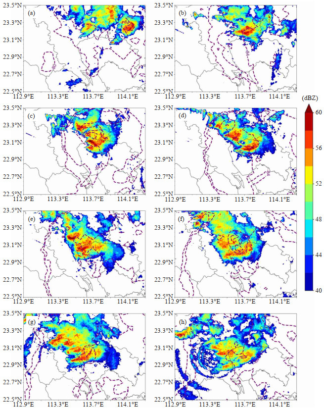
图 6 2020年5月22日不同时刻的广州雷达组合反射率因子(彩色填图,单位:dBZ)和TBB(紫色虚线,单位:℃)分布
a. 21日23:00;b. 22日00:00;c. 22日00:30;d. 22日01:00;e. 22日01:30;f. 22日02:00;g. 22日02:30;h. 22日03:00。

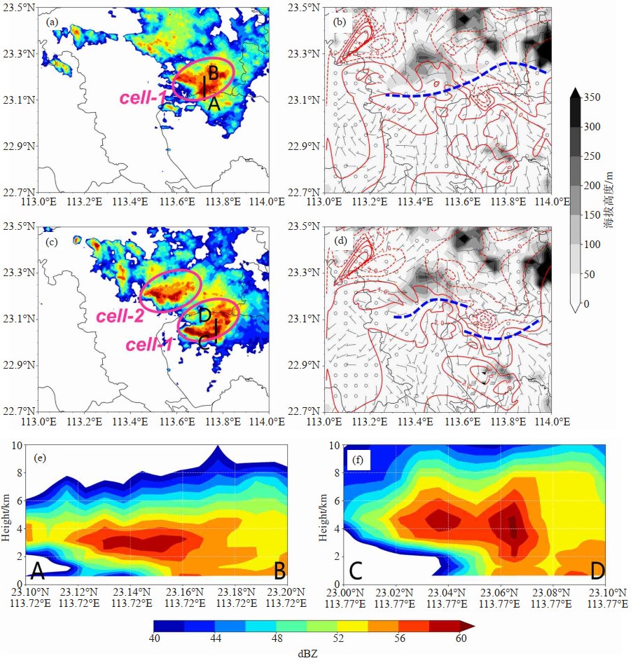
图 7 2020年5月22日00:06(a)、00:48(c)广州雷达反射率因子(填色,单位:dBZ),00:06(b)、00:48(d)的区域温度距平(红色等值线,实线为正距平,虚线为负距平,1 ℃间隔)、风场(单位:m/s)、辐合线,00:06(e)、00:48(f)雷达反射率剖面(填色,单位:dBZ)
灰色阴影为地形,蓝色虚线为辐合线,黑色实线为雷达剖面位置,粉色椭圆圈代表零散对流单体。

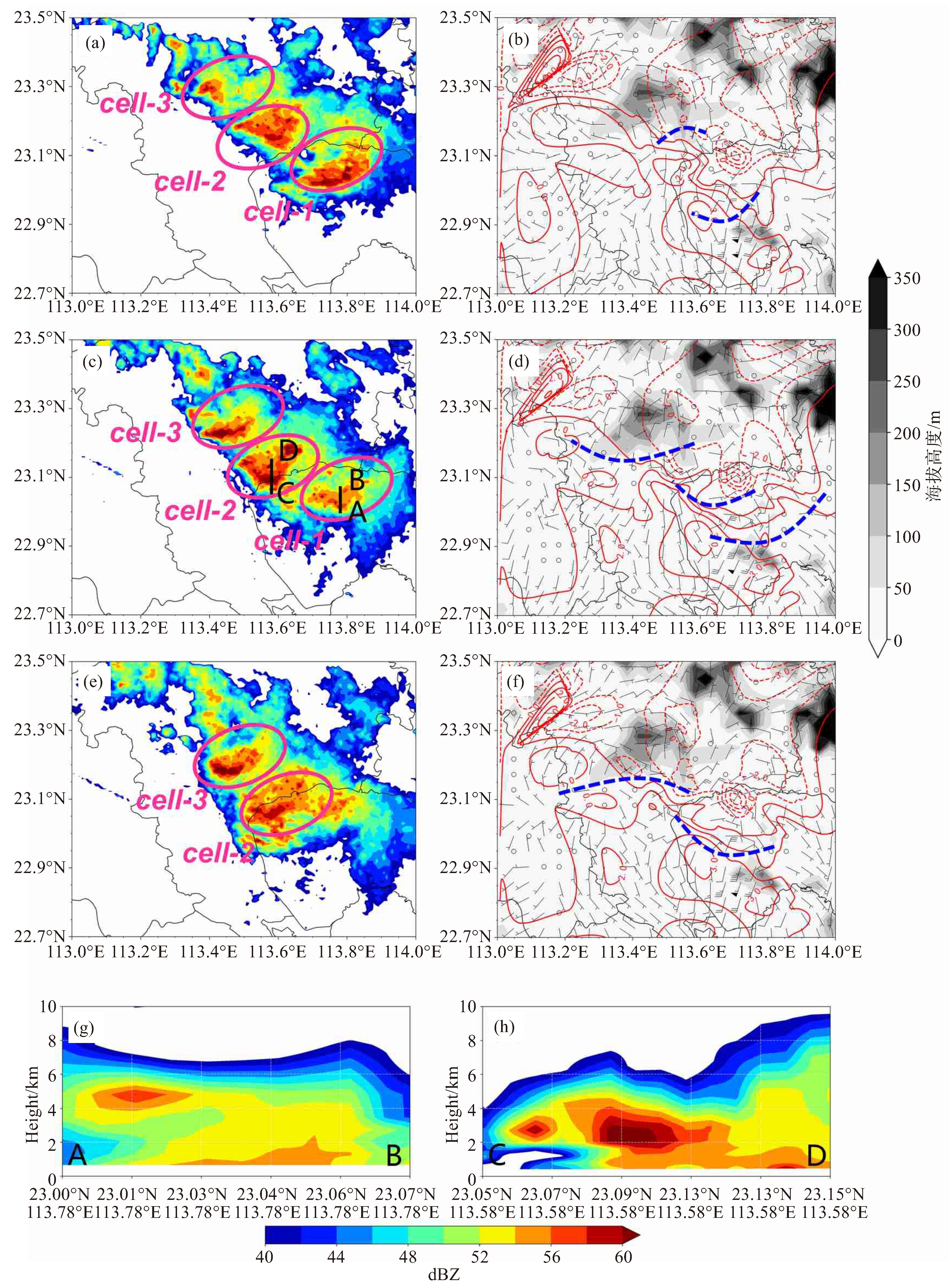
图 8 2020年5月22日01:00(a)、01:18(c)、01:30(e)广州雷达反射率因子(填色,单位:dBZ),01:00(b)、01:15(d)、01:30(f)的区域温度距平(红色等值线,实线为正距平,虚线为负距平,1 ℃间隔)、风场(单位:m/s)、辐合线,01:18AB线(g)01:18CD线(h)雷达反射率剖面(填色,单位:dBZ)
灰色阴影为地形,蓝色虚线为辐合线,黑色实线为雷达剖面位置,粉色椭圆圈代表零散对流单体。

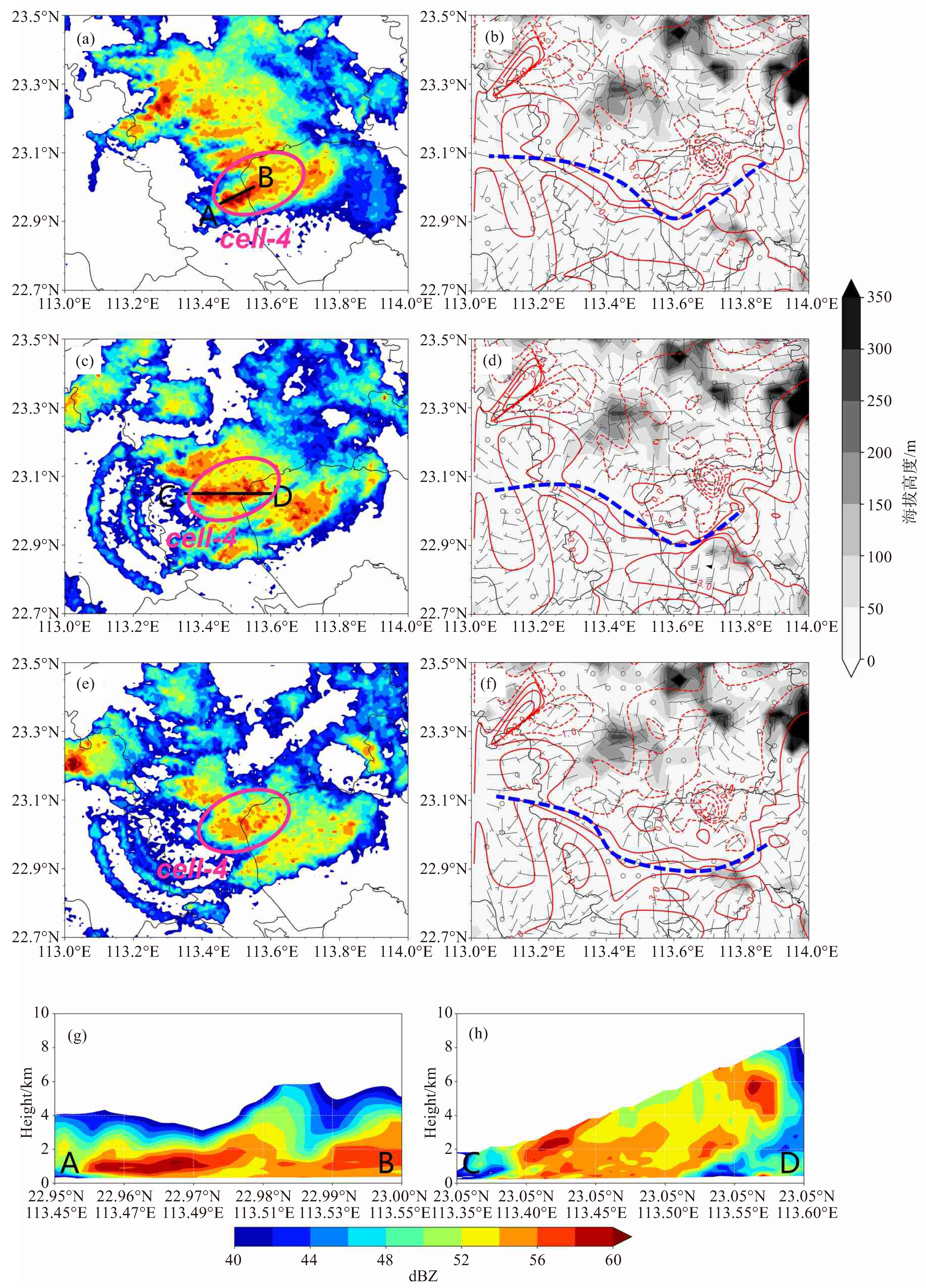
图 9 2020年5月22日02:24(a)、02:54(c)、03:12(e)广州雷达反射率因子(填色,单位:dBZ),02:30(b)、02:45(d)、03:15(f)的区域温度距平(红色等值线,实线为正距平,虚线为负距平,1 ℃间隔)、风场(单位:m/s)、辐合线,02:24(g)、02:54(h)雷达反射率剖面(填色,单位:dBZ)
灰色阴影为地形,蓝色虚线为辐合线,黑色实线为雷达剖面位置,粉色椭圆圈代表零散对流单体。
-
[1] 陶诗言. 中国之暴雨[M]. 北京: 科学出版社, 1980. [2] WU M, LUO Y, CHEN F, et al. Observed link of extreme hourly precipitation changes to urbanization over coastal South China[J]. J Appl Meteor Climatol, 2019, 58(8): 1799-1819. [3] 周秀骥, 薛纪善, 陶祖钰. 98年华南暴雨科学试验研究[M]. 北京: 气象出版社, 2003: 1-228. [4] 周秀骥. 海峡两岸及邻近地区暴雨试验研究[M]. 北京: 气象出版社, 2000. [5] 池艳珍, 何金海, 吴志伟. 华南前汛期不同降水时段的特征分析[J]. 南京气象学院学报, 2005, 28(2): 163-171. [6] 柳艳菊, 丁一汇, 宋艳玲. 1998年夏季风爆发前后南海地区的水汽输送和水汽收支[J]. 热带气象学报, 2005, 21(1): 55-62. [7] 刘亚楠, 王东海, 李国平, 等. 南海夏季风爆发前后华南前汛期降水日变化对比分析[J]. 热带气象学报, 2019, 35(3): 365-378. [8] 黄士松. 华南前汛期暴雨[M]. 广州: 广东科技出版社, 1986: 94-95. [9] 何立富, 陈涛, 孔期. 华南暖区暴雨研究进展[J]. 应用气象学报, 2016, 27(5): 559-569. [10] 高守亭, 孙淑清. 次天气尺度低空急流的形成[J]. 大气科学, 1984, 8(2): 178-188. [11] CHEN G T J, WANG C C, LIN D T W. Characteristics of low-level jets over northern Taiwan in mei-yu season and their relationship to heavy rain events[J]. Mon Wea Rev, 2005, 133(1): 20-43. [12] 翟国庆, 丁华君, 孙淑清, 等. 与低空急流相伴的暴雨天气诊断研究[J]. 大气科学, 1999, 23(1): 112-118. [13] 林良勋. 广东省天气预报技术手册[M]. 北京: 气象出版社, 2006: 119-150. [14] MATSUMOTO S, AKIYAMA T. Mesoscale disturbances and related rainfall cells embedded in the "Baiu front", with a proposal on the role of convective momentum transfer[J]. J Meteor Soc Japan Ser Ⅱ, 1970, 48(2): 91-102. [15] 王坚红, 杨艺亚, 苗春生, 等. 华南沿海暖区辐合线暴雨地形动力机制数值模拟研究[J]. 大气科学, 2017, 41(4): 784-796. [16] 曾智琳, 谌芸, 王东海. 2018年8月华南超历史极值降水事件的观测分析与机理研究[J]. 大气科学, 2020, 44(4): 695-715. [17] WANG H, LUO Y, JOU B J D. Initiation, maintenance, and properties of convection in an extreme rainfall event during SCMREX: Observational analysis[J]. J Geophys Res Atmos, 2014, 119(23): 13, 206-13, 232. [18] 苗春生, 杨艺亚, 王坚红, 等. 两类华南沿海暖区暴雨特征及热力发展机制对比研究[J]. 热带气象学报, 2017, 33(1): 53-63. [19] 夏茹娣, 赵思雄, 孙建华. 一类华南锋前暖区暴雨β中尺度系统环境特征的分析研究[J]. 大气科学, 2006, 30(5): 988-1008. [20] 伍志方, 叶爱芬, 胡胜, 等. 中小尺度天气系统的多普勒统计特征[J]. 热带气象学报, 2004, 20(4): 391-400. [21] CHEN G T J, WANG C C, CHANG S W. A diagnostic case study of mei-yu frontogenesis and development of wavelike frontal disturbances in the subtropical environment[J]. Mon Wea Rev, 2008, 136(1): 41-61. [22] CHEN S J, KUO Y H, WANG W, et al. A modeling case study of heavy rainstorms along the Mei-Yu front[J]. Mon Wea Rev, 1998, 126(9): 2330-2351. [23] 张晓惠, 倪允琪. 华南前汛期锋面对流系统与暖区对流系统的个例分析与对比研究[J]. 气象学报, 2009, 67(1): 108-121. [24] 林宗桂, 李耀先, 林开平, 等. 一个长生命期中尺度对流系统维持机制的研究[J]. 气象学报, 2009, 67(4): 640-651. [25] LUO Y, GONG Y, ZHANG D L. Initiation and organizational modes of an extreme-rain-producing mesoscale convective system along a Mei-Yu front in East China[J]. Mon Wea Rev, 2014, 142(1): 203-221. [26] 孙继松. 短时强降水和暴雨的区别与联系[J]. 暴雨灾害, 2017, 36(6): 498-506. [27] 万轶婧, 王东海, 梁钊明, 等. 华南暖区暴雨环境参量的统计分析[J]. 中山大学学报(自然科学版), 2020, 59(6): 51-63. -

 下载:
下载:
 点击查看大图
计量
- 文章访问数: 383
- HTML全文浏览量: 129
- PDF下载量: 68
- 被引次数: 0
 粤公网安备 4401069904700003号