


Characteristics of Warm-Sector Rainstorms in Southern Hunan Province from 2012 to 2021
-
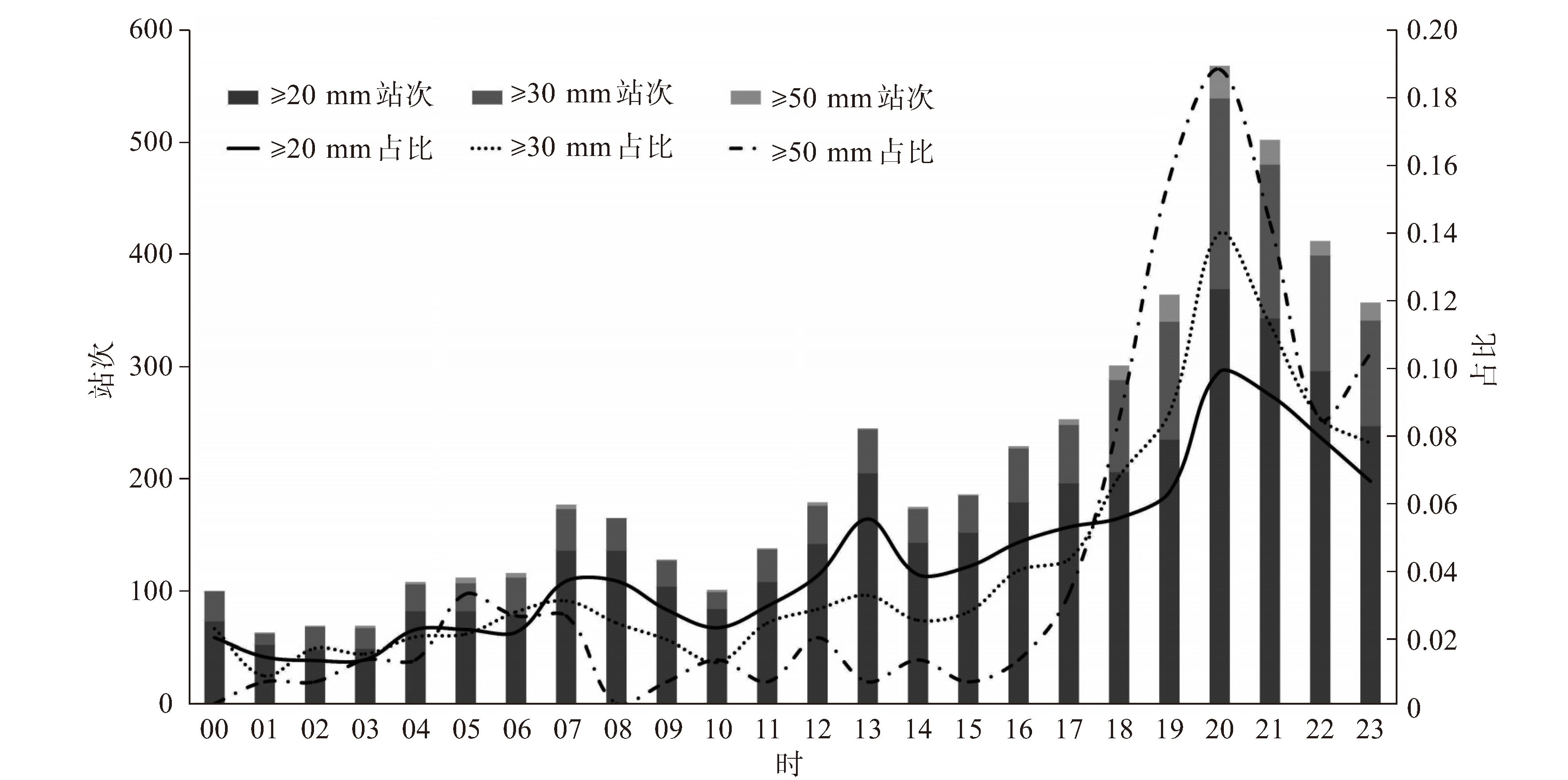
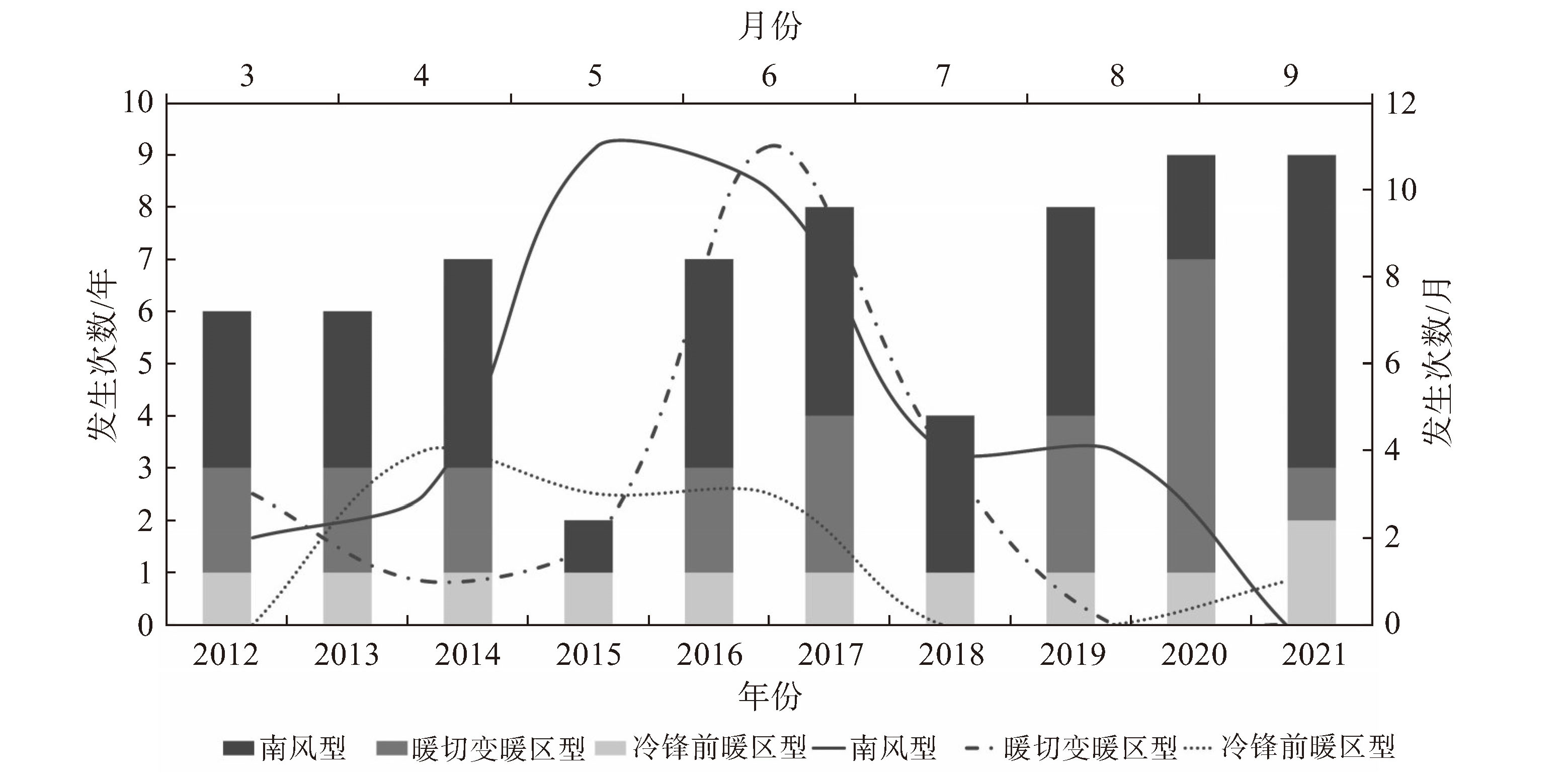
摘要: 基于2012—2021年3—9月66个暖区暴雨个例,利用地面、高空等常规资料及再分析数据,分析了湘南地区暖区暴雨的时空分布特征,分冷锋前暖区型、南风型和暖切变暖区型三类建立天气学概念模型,并提取暴雨发生前各物理量指标,结果表明:(1)湘南暖区暴雨年变化呈现波动增长趋势,日变化峰值出现在19—22时,5月范围最广,6月次数最多,日雨量极值最大,7—9月局地性强;(2)南风型占比和日雨量极值最大,暖切变暖区型次之,冷锋前暖区型最小,三种类型分别多发于4—6月、5—8月和6—7月;(3)冷锋前暖区型、暖切变暖区型短时强降水(小时雨量≥ 20 mm)日变化较剧烈,南风型略平缓;(4)湘南暖区暴雨发生的高频区与南岭、罗霄山脉和阳明山地形分布息息相关,东江湖对暖区暴雨也有增幅作用,冷锋前暖区型更易发生在西南部的喇叭口地形处,暖切变暖区型集中于南部南岭迎风坡和不均匀下垫面附近,南风型发生点较分散;(5)湘南暖区暴雨的主要影响系统是高空低槽、低空和超低空急流、地面倒槽和辐合线,另外200 hPa分流区、850 hPa暖脊和显著湿区以及地形作用对降水起到增幅效果;(6)700 hPa、850 hPa、925 hPa急流分别对冷锋前暖区型、暖切变暖区型和南风型暖区暴雨的水汽输送起重要作用;(7)湘南暖区暴雨发生前各物理量平均值显示,q850(850 hPa比湿)≥ 13 g·kg-1,CAPE(对流有效位能)≥ 1 100 J·kg-1,K指数≥ 37 ℃,SI(沙氏指数)≤ -1.5,T850-500(850 hPa与500 hPa温差)≥ 23 ℃,LCL(抬升凝结高度)在0.6~0.9 km间,0 ℃层高度在4.9~5.1 km间,0~6 km的垂直风切变在10~16 J·kg-1间。Abstract: By using conventional observational data and NCEP reanalysis data, the present study analyzed the temporal and spatial distribution characteristics of 66 warm-sector rainstorm (WR) cases in southern Hunan province from March to September between 2012 and 2021. These cases were categorized into three distinct types based on synoptic situation: warm sector in front of cold front (CF) type, southerly wind (SW) type, and warm shear (WS) type. Synoptic conceptual models were established for each type, and the physical parameters leading to these storms were explored. The results show that: (1) The annual variability of WRs in southern Hunan exhibited an undulating upward trend, with daily peaks occurring between 19:00 and 22:00. The storms were most extensive in May, most frequent in June with the highest maximum daily rainfall, and more localized from July to September. (2) The SW type was the most frequent with the highest maximum daily rainfall, followed by the WS type, while the CF type was the least common, with each type peaking in different months: April to June for the CF type, May to August for the SW type, and June to July for the WS type. (3) The diurnal variation of short-duration strong rainfall (hourly rainfall≥20 mm) of the CF type and the WS type was intense, while that of the SW type was slightly gentle. (4) The high-frequency area for WRs was closely related to the terrain distribution of the Nanling Mountains, Luoxiao Mountains, and Yangming Mountains; the Dongjiang Lake also contributed to increased precipitation. The CF type was more likely to occur at trumpet-shaped topography in the southwest; the WS type was concentrated on the windward slope of the Nanling Mountains and near different underlying surfaces, while the SW type's occurrence was more dispersed. (5) The main influencing systems included upper-level troughs, low-level and ultra-low-level jet streams, surface inverted troughs, and convergence lines. Moreover, the 200 hPa divergence zone, the 850 hPa warm high ridge, the significantly humid region, and the topographic effect contributed to increased precipitation. (6) The jet streams at 700 hPa, 850 hPa, and 925 hPa played important roles in the water vapor transport of the CF type, the WS type, and the SW type rainstorms, respectively. (7) The average values of physical parameters before WRs were as follows: specific humidity of 850 hPa≥13 g·kg-1, CAPE≥1 100 J·kg-1, K-index≥37 ℃, Showalter index≤-1.5, temperature difference between 850 hPa and 500 hPa ≥23 ℃, lifting condensation level between 0.6 and 0.9 km, 0 ℃ isotherm height between 4.9 and 5.1 km, and 0-6 km vertical wind shear between 10 m·s-1 and 16 m·s-1.
-

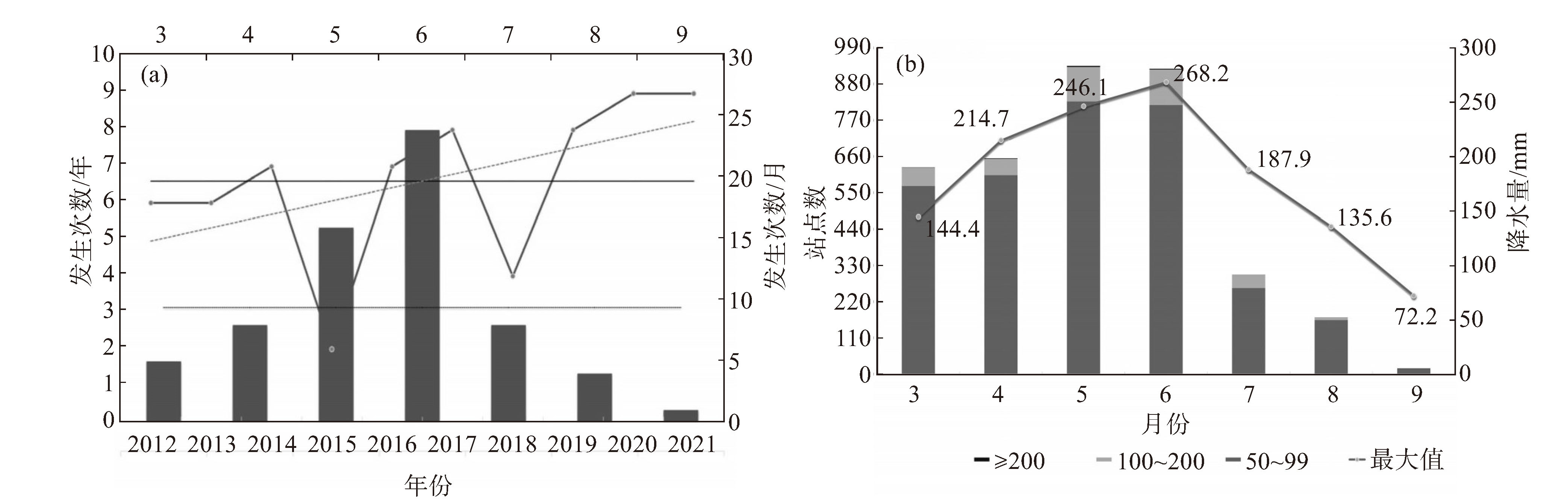
图 1 湘南暖区暴雨的年际和月际变化(a,年际变化:折线图;年变化趋势:灰虚线;年平均:黑实线;月际变化:柱状图;月平均:黑点线;左轴、右轴纵坐标分别为年、月次数),日降水量极值月变化(b,不同量级降水站点数:柱状图;日降雨量极值:折线图)

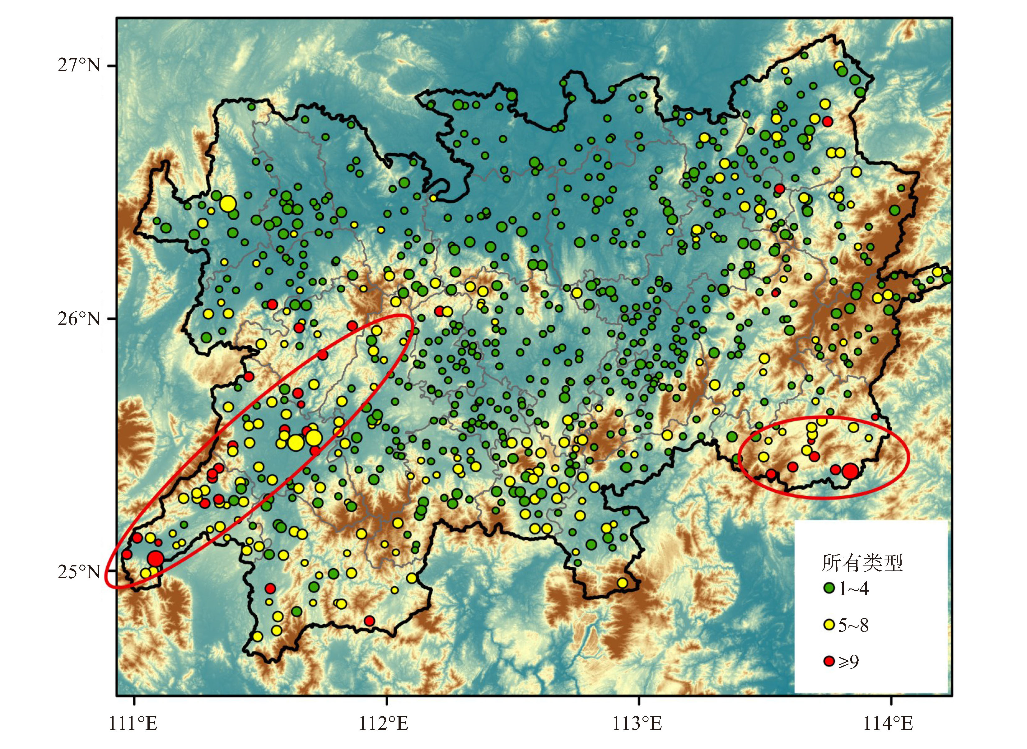
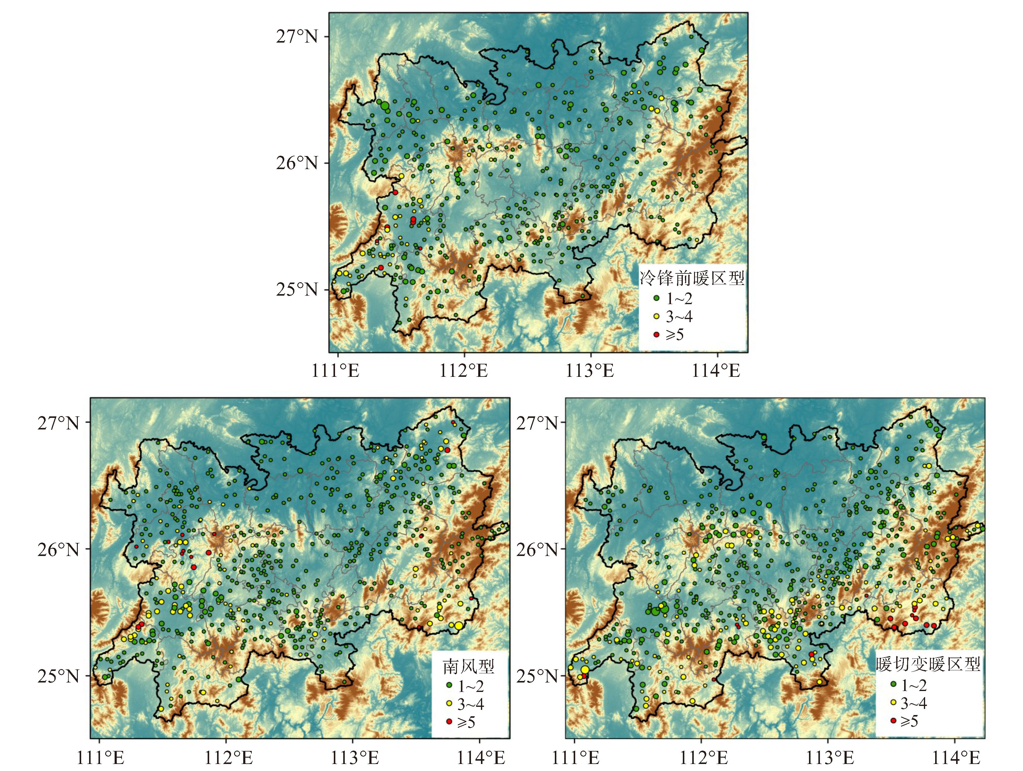
图 7 冷锋前暖区型(a)、南风型(b)、暖切变暖区型(c)暖区暴雨空间分布
彩色圆点:站点发生暖区暴雨频次;填色:地形;圆点从小到大分别代表日降水≥50 mm、≥100 mm和≥200 mm。

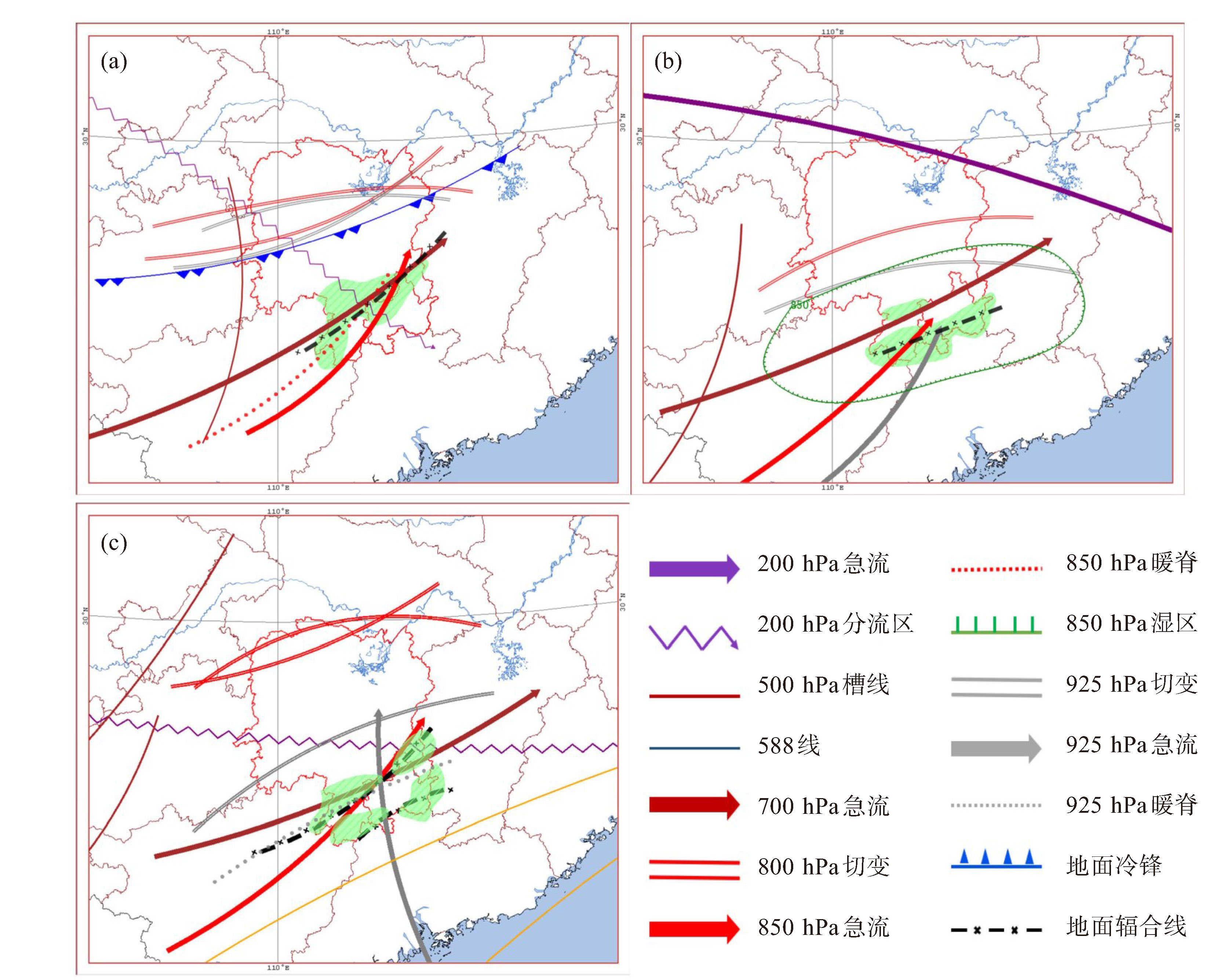
图 8 冷锋型暖区型(a)、南风型(b)、暖切变暖区型(c)暖区暴雨发生时850 hPa水汽通量异常场
箭头:水汽通量;填色:水汽通量大小;单位:g·cm-1·hPa-1·s-1。
表 1 不同类型暖区暴雨环境物理量参数的平均值
暖区暴雨类型 850 hPa风速/(m·s-1) 850 hPa比湿/(g·kg-1) T85/℃ SI指数/℃ K指数/℃ CAPE/(J·kg-1) CIN/(J·kg-1)/m LCL/m LFC/m 0 ℃层高度/m 0~3 km风切变/(m·s-1) 0~6 km风切变/(m·s-1) 南风型 9.4 14.0 23.5 -1.5 37.5 1 351.3 48.7 788.8 877.2 5 029.7 9.3 10.7 冷锋前暖区型 10.3 13.3 24.7 -1.8 38.4 1 290.4 67.4 654.1 843.1 4 918.6 12.7 15.9 暖切变暖区型 7.0 14.3 24.2 -2.0 38.3 1 195.0 71.4 875.4 834.1 5 016.8 11.3 13.8 注:T85为850 hPa与500 hPa温度差。  下载: 导出CSV
-
[1] 黄士松, 李真光, 包澄澜, 等. 华南前汛期暴雨[M]. 广州: 广东科技出版社, 1986: 212-244. [2] 高守亭, 周玉淑, 冉令坤. 我国暴雨形成机理及预报方法研究进展[J]. 大气科学, 2018, 42(4): 833-846. [3] 谌芸, 陈涛, 汪玲瑶, 等. 中国暖区暴雨的研究进展[J]. 暴雨灾害, 2019, 38(5): 483-493. [4] 伍志方, 蔡景就, 林良勋, 等. 2017年广州"5·7"暖区特大暴雨的中尺度系统和可预报性[J]. 气象, 2018, 44(4): 485-499. [5] 何立富, 陈涛, 孔期. 华南暖区暴雨研究进展[J]. 应用气象学报, 2016, 27(5): 559-569. [6] 陈翔翔, 丁治英, 刘彩虹, 等. 2000—2009年5、6月华南暖区暴雨形成系统统计分析[J]. 热带气象学报, 2012, 28(5): 707-718. [7] 丁治英, 刘彩虹, 沈新勇. 2005—2008年5、6月华南暖区暴雨与高、低空急流和南亚高压关系的统计分析[J]. 热带气象学报, 2011, 27(3): 307-316. [8] 陈玥, 谌芸, 陈涛, 等. 长江中下游地区暖区暴雨特征分析[J]. 气象, 2016, 42(6): 724-731. [9] 田莹, 叶成志, 姚蓉. 2008-2018年江南暖区暴雨特征[J]. 大气科学学报, 2022, 45(1): 51-64. [10] 肖红茹, 王佳津, 肖递祥, 等. 四川盆地暖区暴雨特征分析[J]. 气象, 2021, 47(3): 303-316. [11] 孙密娜, 王秀明, 胡玲, 等. 华北一次暖区暴雨雷暴触发及传播机制研究[J]. 气象, 2018, 44(10): 1 255-1 266. [12] 徐珺, 杨舒楠, 孙军, 等. 北方一次暖区大暴雨强降水成因探讨[J]. 气象, 2014, 40(12): 1 455-1 463. [13] 陈芳丽, 刘显通, 曾丹丹, 等. 珠三角北部一次暖区强降水过程中的地形作用[J]. 热带气象学报, 2022, 38(3): 377-386. [14] 孙建华, 赵思雄. 一次罕见的华南大暴雨过程的诊断与数值模拟研究[J]. 大气科学, 2000, 24(3): 381-392. [15] 夏茹娣, 赵思雄. 2005年6月广东锋前暖区暴雨β中尺度系统特征的诊断与模拟研究[J]. 大气科学, 2009, 33(3): 468-488. [16] ZHANG R H, NI Y Q, LIU L P, et al. South China heavy rainfall experiments(SCHeREX)[J]. J Meteor Soc Japan, 2011, 89A(2): 153-166. [17] 付炜, 唐明晖, 叶成志, 等. 强西南急流背景下南岭山脉一次暖区大暴雨数值模拟分析[J]. 热带气象学报, 2022, 38(2): 203-215. [18] 刘瑞鑫, 孙建华, 陈鲍发. 华南暖区暴雨事件的筛选与分类研究[J]. 大气科学, 2019, 43(1): 119-130. [19] 刘瑞鑫, 孙建华, 傅慎明. 不同类型华南暖区暴雨过程的环流特征[J]. 气候与环境研究, 2021, 26(4): 359-373. [20] 汪玲瑶, 谌芸, 肖天贵, 等. 夏季江南地区暖区暴雨的统计分析[J]. 气象, 2018, 44(6): 771-780. [21] 肖递祥, 王佳津, 曹萍萍, 等. 2020四川盆地突发性暖区暴雨特征及环境场条件分析[J]. 自然灾害学报, 2020, 29(3): 110-118. [22] 苗春生, 杨艺亚, 王坚红, 等. 两类华南沿海暖区暴雨特征及热力发展机制对比研究[J]. 热带气象学报, 2017, 33(1): 53-63. -


 点击查看大图
图(8) / 表(1)
计量
- 文章访问数: 37
- HTML全文浏览量: 9
- PDF下载量: 25
- 被引次数: 0
 粤公网安备 4401069904700003号