EOF-based Analysis of Distribution and Environmental Field of Typhoon Rainstorms in Jiangxi
-
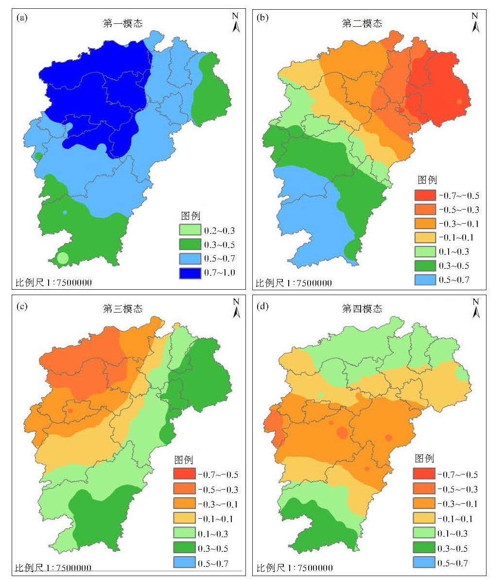
摘要: 基于1961—2019年影响江西的179个台风暴雨过程降雨资料和ECMWF再分析0.125 °×0.125 °资料,结合台风暴雨分布的EOF分型和登陆地点分类分析得出江西的台风强降水主要有5种分布类型,构建台风暴雨的预报模型,以期提高台风暴雨的预报准确率。所有台风强降雨个例中台风环流与副高之间存在明显的急流,进入江西时仍有螺旋雨带,除了台风路径和强度,暴雨落区主要与高层辐散、环流内低层辐合、地形、西风带系统、西南季风等有关。全省型: 200 hPa上江西中北部处南亚高压中,台风登陆福建在副高西侧西北行穿过江西,环流四周的低层急流和气旋性切变造成暴雨、大暴雨;台风登陆广东在两环副高之间北上,与西风带系统结合造成江西大范围强降雨和远距离暴雨; 台风登陆浙江在副高南侧西行进入江西北部,螺旋雨带造成大范围强降雨。中南型: 配合200 hPa上江西北部有辐合区、南部为辐散区,台风登陆福建西行穿过江西中南部,对流层中层急流位于江西北部限制了雨区向北发展,强降雨出现在台风西侧、东侧的急流前部或南侧气旋性切变中;台风登陆广东东行,东侧东南急流与地形、西风带系统结合,造成江西中南部强降雨。东北型: 台风登陆福建北上穿过赣东北,受西南季风影响,环流四周低空急流和气旋性切变配合高层辐散造成江西东北部强降雨。台风登陆浙江西行在安徽境内徘徊,螺旋雨带造成赣东北强降雨。东南型:200 hPa上有高空槽东移影响江西,台风登陆福建从副高西侧北上,台风长轴转为东北-西南向,环流东侧偏南急流、南侧气旋性切变造成江西东部、南部强降雨。中部型: 台风登陆福建西北行穿过江西中部,对流层中层急流位于江西北部,台风南侧辐合区配合200 hPa上江西中部有辐散区造成强降雨。Abstract: The present study aimed to develop a forecasting model for typhoon rainstorms to improve the accuracy of forecasts for such events. Based on rainfall data of 179 typhoon rainstorm events affecting Jiangxi between 1961 and 2019 and the European Centre for Medium-Range Weather Forecasts reanalysis data at a resolution of 0.125 °×0.125 °, we conducted empirical orthogonal function (EOF) classification and landing site classification analysis and identified five distribution types of typhoon rainstorms in Jiangxi. In all the cases, obvious jets were observed between typhoon circulation and the subtropical high. Spiral rainbands were present when typhoons entered Jiangxi. In addition to its correlation with typhoon path and intensity, the rainstorm area was predominantly influenced by upper-level divergence, low-level convergence in typhoon circulation, terrain, the westerly wind belt, and the southwest monsoon. The distribution types of these typhoon rainstorms include: (1) Provincial type. The north-central part of Jiangxi was under the influence of the South Asian high. Typhoons that landed in Fujian passed through Jiangxi's northwest on the west side of the subtropical high. The low-level jet stream and cyclonic shear around the typhoon circulation caused rainstorms and even heavy rainstorms. Typhoons that landed in Guangdong moved northward between two subtropical highs. Combined with the westerly wind belt, they caused largescale heavy rainfall and long-distance rainstorms in Jiangxi. Typhoons that made landfall in Zhejiang headed westward on the south side of the subtropical high and entered the northern part of Jiangxi. Their spiral rainband caused widespread heavy rainfall. (2) Central-South type. With a convergence zone in the north of Jiangxi and a divergence zone in the south at the 200 hPa level, typhoons made landfall in Fujian and traveled westward through the central and southern parts of Jiangxi. The mid-level jet stream in the troposphere was located in the northern part of Jiangxi and it limited the development of the rainfall event to the north. Heavy rainfall events occurred in the front of the jet stream on the west / east side of the typhoons or in the cyclonic shear on the south side. When typhoons made landfall in Guangdong and moved eastward, the southeast jet stream on the east side, combined with terrain and westerly wind belt, caused heavy rainfall in the central and southern parts of Jiangxi. (3) Northeast type. When typhoons made landfall in Fujian and moved northward through northeastern Jiangxi, the low-level jet and cyclonic shear around the circulation were influenced by the southwest monsoon. Combined with high-level divergence, they caused heavy rainfall in northeast Jiangxi. Typhoons that made landfall in Zhejiang hovered westward within Anhui, and the spiral rainband caused heavy rainfall in northeastern Jiangxi. (4) Southeast type. At the 200 hPa level, a high-altitude trough moved eastward and affected Jiangxi. Typhoons made landfall in Fujian and moved northward from the west side of the subtropical high. The long axis of the typhoon shifted to a northeast-southwest direction, and the southerly jet stream on the east side of the circulation and cyclonic shear on the south side caused heavy rainfall in the southeastern part of Jiangxi. (5) Central type, where the typhoon made landfall in the northwest of Fujian and passed through the central part of Jiangxi. The mid-level jet stream in the troposphere was located in the northern part of Jiangxi. The convergence area on the south side of the typhoon, combined with the divergence area at 200 hPa, caused heavy rainfall in the central part of Jiangxi.
-
Key words:
- typhoon /
- rainstorm /
- empirical orthogonal function (EOF) /
- environmental field
-
表 1 前4个模态的台风强降雨个例
登陆浙江 登陆广东 登陆福建 第一模态 7209、7504、0414 8411、9009、9116、8006、8116、9403、9505、9710、0212 9406、9714、6122、7412、7704、6911、1617、1307、0808、0513 示意图(a) 示意图(b) 示意图(c) 第二模态-正 -- 1804 9608、6120、0709、0604 -- 示意图(d) 示意图(d) 第二模态-负 1211 -- 7301、1513 示意图(f) 示意图(g) -- 第三模态-正 -- -- 8012、9018、1400、0010 -- -- 示意图(h) 第四模态-负 -- -- 6906、1312 -- -- 示意图(i) 
-
[1] 陈联寿, 丁一汇. 西太平洋台风概论[M]. 北京: 科学出版社, 1979. [2] 梁必骐, 王安宇, 梁经萍, 等. 热带气象学[M]. 广州: 中山大学出版社, 1990. [3] 端义宏, 陈联寿, 梁建茵, 等: 台风登陆前后异常变化的研究进展[J]. 气象学报, 2014, 72(5): 969-986. [4] YU Z F, YU H, GAO S T. Terrain impact on the precipitation of landfalling typhoon Talim[J]. J Trop Meteor, 2010, 16(2): 115-124. [5] 陈红专, 毛紫怡, 陈静静. 中国近30年有/无大气河伴随的登陆台风气候学特征对比分析[J]. 气象学报, 2020, 78(5): 745-760. [6] 官晓军, 潘宁, 黄待静, 等. 基于降水极端预报指数的福建台风极端降水预报研究[J]. 气象学报, 2021, 79(3): 414-427. [7] 李晓娟, 梁健, 谢定升, 等. 华南热带气旋影响时段的短期气候集成预测[J]. 热带气象学报, 2020, 36(2): 157-165. [8] 马艳, 董海鹰, 郝燕, 等. 登陆青岛的热带气旋及其降水特征分析[J]. 海洋气象学报, 2021, 41(1): 109-118. [9] 陆桂荣, 王文, 郑美琴, 等. 海南台风暴雨的时空分布特征[J]. 大气科学学报, 2015, 38(5): 710-715. [10] 王红霞. 登陆我国台风暴雨的时空分布特征及其成因分析[D]. 南京: 南京信息工程大学, 2010. [11] ELSBERY R L. 热带气旋全球观[M]. 北京: 气象出版社, 1994. [12] 许映龙, 高拴柱, 刘震坤. 台风云娜陆上维持原因浅析[J]. 气象, 2005, 31(5): 32-36. [13] 李江南, 王安宇, 杨兆礼, 等. 台风暴雨的研究进展[J]. 热带气象学报, 2003, 19(增刊): 152-159. [14] 雷小途, 陈联寿. 热带气旋的登陆及其与中纬度环流系统相互作用的研究[J]. 气象学报, 2021, 59(5): 602-612. [15] 许爱华, 陈涛, 朱光宇, 等". 泰利"台风低压大暴雨过程分析和数值模拟试验. 气象与减灾研究, 2006, 29(2): 25-31. [16] 何立富, 许爱华, 陈涛. "泰利"台风低压大暴雨过程冷空气与地形的作用[J]. 气象科技, 2009, 37(4): 385-391. [17] 张娟娟, 刘波, 张瑛. 台风"鲇鱼"(1617)导致的江西持续性暴雨天气过程成因[J]. 气象与减灾研究, 2021, 44(1): 16-24. [18] 周芯玉, 程正泉, 涂静, 等. 台风艾云尼非对称降水及动热力结构演变特征分析[J]. 气象学报, 2020, 78(6): 899-913. [19] 林爱兰, 郑彬, 谷德军, 等. 2006年东亚夏季风活动特征与我国东部雨带分布[J]. 热带气象学报, 2009, 25(2): 129-140. [20] 邹毅, 王德辉, 杨妮, 等. "碧利斯"引发罗霄山区局地特大暴雨的过程及成因分析[J]. 灾害学, 2019, 34(2): 110-114. [21] 周芳, 陈翔翔, 郭达烽, 等. 台风"海葵"(2012)造成的景德镇特大暴雨过程分析[J]. 气象与减灾研究, 2013, 36(3): 35-42. [22] 黄昌兴, 周芳, 薛谌彬. 台风"潭美"(2013)偏心不对称结构特征分析及数值模拟[J]. 气象与减灾研究, 2014, 37(2): 11-18. -


 下载:
下载:


 粤公网安备 4401069904700003号