


Observational Analysis of an Extreme Gale Event: A Multi-Source Data Approach
-
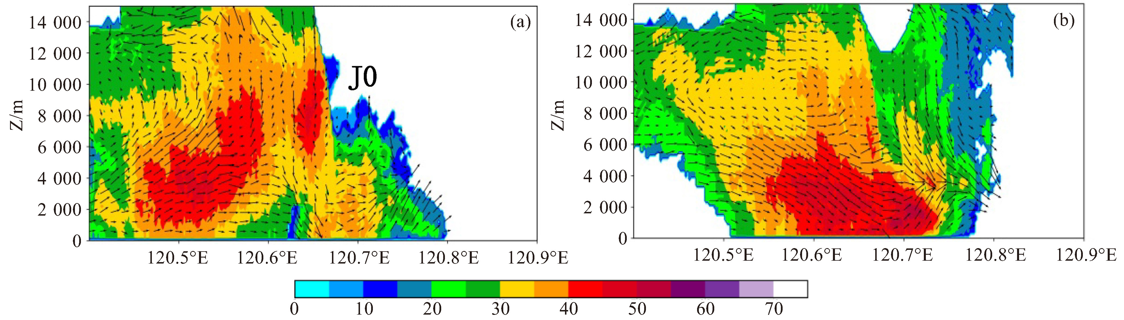
摘要: 利用常规高空、地面观测资料、ERA5再分析资料(0.25 °×0.25 °)、S波段双偏振雷达资料、X波段相控阵雷达资料等,对2022年7月25日浙江一次极端大风的环流背景、对流系统演变特征、成因等进行了分析。(1) 此次极端大风事件发生在副高外围短波槽东移的大尺度环境下,具有低层水汽充沛、高空干层显著、强的不稳定层结等有利条件,地面中尺度辐合线为极端大风的产生提供了触发机制。(2) 极端大风由单体J0造成,利用X波段相控阵雷达及其风场反演可以分析J0的精细结构演变,J0的涡旋结构首先生成于中层,然后向上、向下发展,最后涡旋结构从低层至高层逐渐减弱消亡,同时中层出现明显的辐合;垂直方向上,J0生成后与其后侧的单体合并,在反射率因子梯度大值区上空,与低层的上升气流辐合,在其前沿形成辐合下沉气流。(3) J0生成后使地面冷池增强,同时J0与其后侧的单体合并,下沉气流增强,到达地面后在气压梯度作用下,使风速进一步增强,是极端大风产生的主要成因。此外,环境干空气卷入风暴内部产生的负浮力和降水粒子的拖曳作用也是极端大风产生的原因之一。Abstract: This study utilized conventional upper-air and surface observational data, ERA5 hourly reanalysis data (0.25 °×0.25 °), S-band dual-polarization radar data, and X-band phased-array radar data to analyze the circulation background, convective system evolution, and the causes of an extreme gale event that occurred in Zhejiang on July 25, 2022. The results indicated that: (1) The extreme gale event occurred under the background of a shortwave trough moving eastwards around the Subtropical High, with favorable conditions such as abundant low-level water vapor, significant upper-level dry layers, and strong unstable stratification. The surface mesoscale convergence line played a pivotal role in triggering the event. (2) The extreme gale was caused by cell J0, whose intricate evolution was captured by the X-band phased-array radar and its wind field inversion. The vortex structure of J0 initially formed in the middle layer, then developed upwards and downwards, and finally weakened and disappeared from the lower to the upper layer, with significant convergence appearing in the middle layer. Vertically, after J0 formed, it merged with the cell behind it, converged with the low-level updraft atop the high reflectivity gradient zone, and formed a converging downdraft at its leading edge. (3) After J0 formed, it enhanced the surface cold pool and, upon merging with the cell behind it, strengthened the sinking airflow. When the airflow reached the ground, it further increased the wind speed under the influence of pressure gradient, which was the primary cause of the extreme gale. In addition, the negative buoyancy generated by the involvement of environmental dry air in the storm and the drag induced by precipitation particles also contributed to the gale's severity.
-

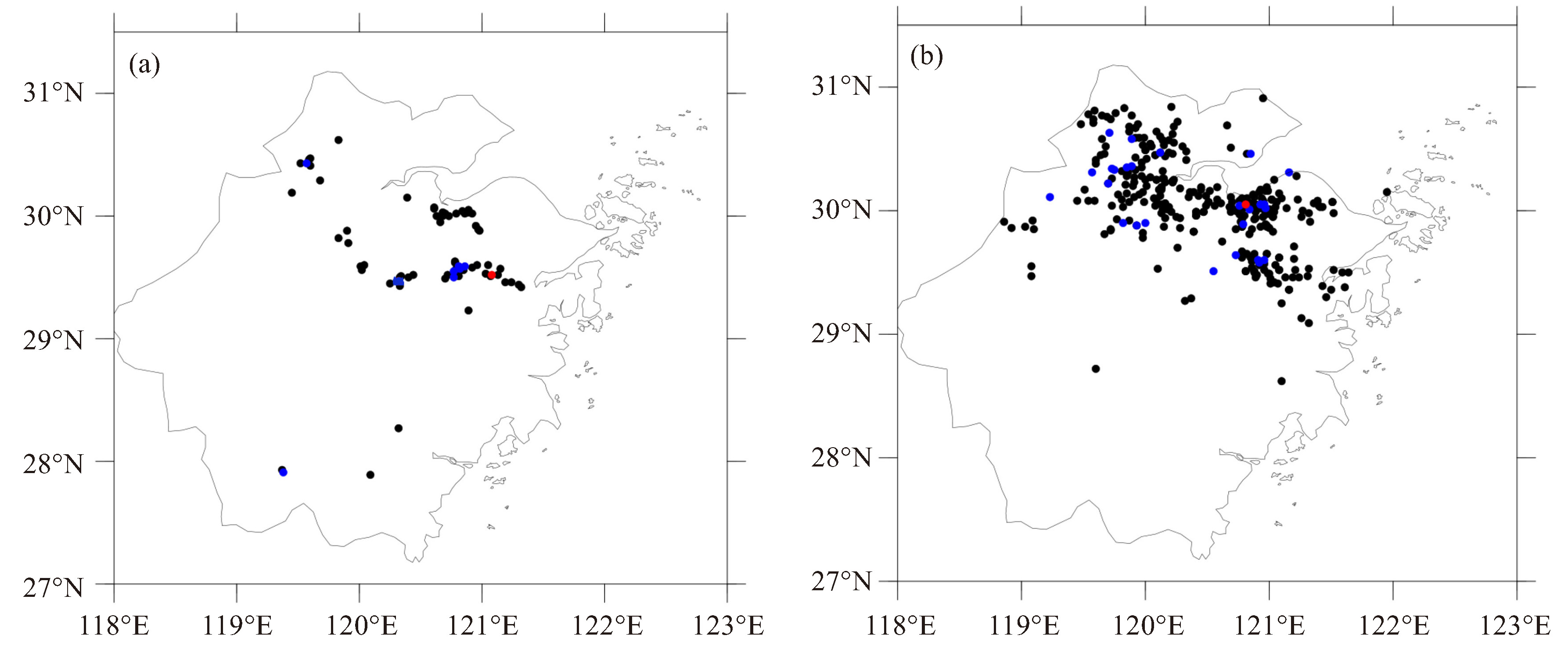
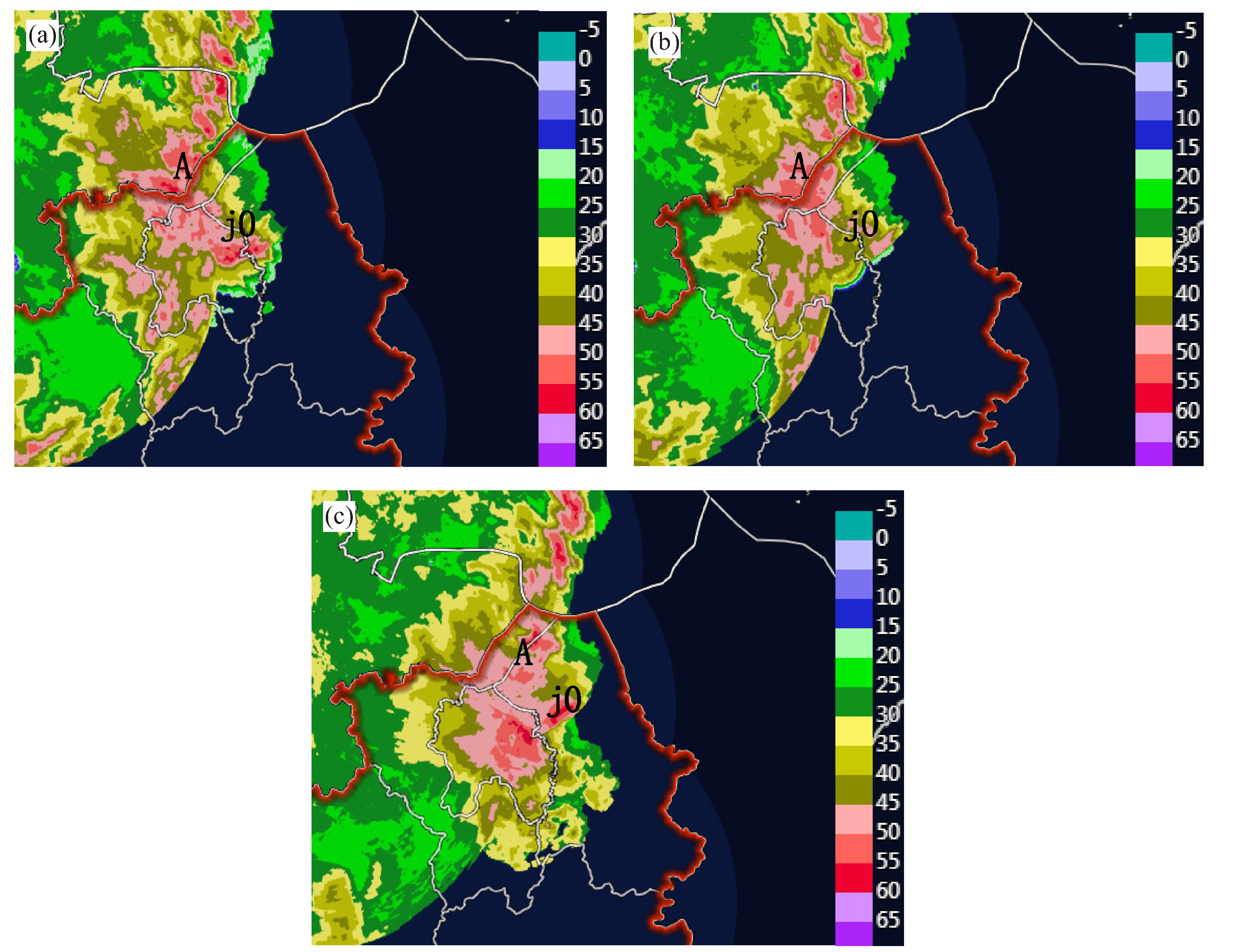
图 4 2022年7月25日15—21时雨量(a)、大风(b)分布图
a中黑点为50~75 mm,蓝点为75~100 mm,红点(念宅站)为100 mm以上;b中黑点为8~9级,蓝点为10~11级,红点(上虞站)为12级。

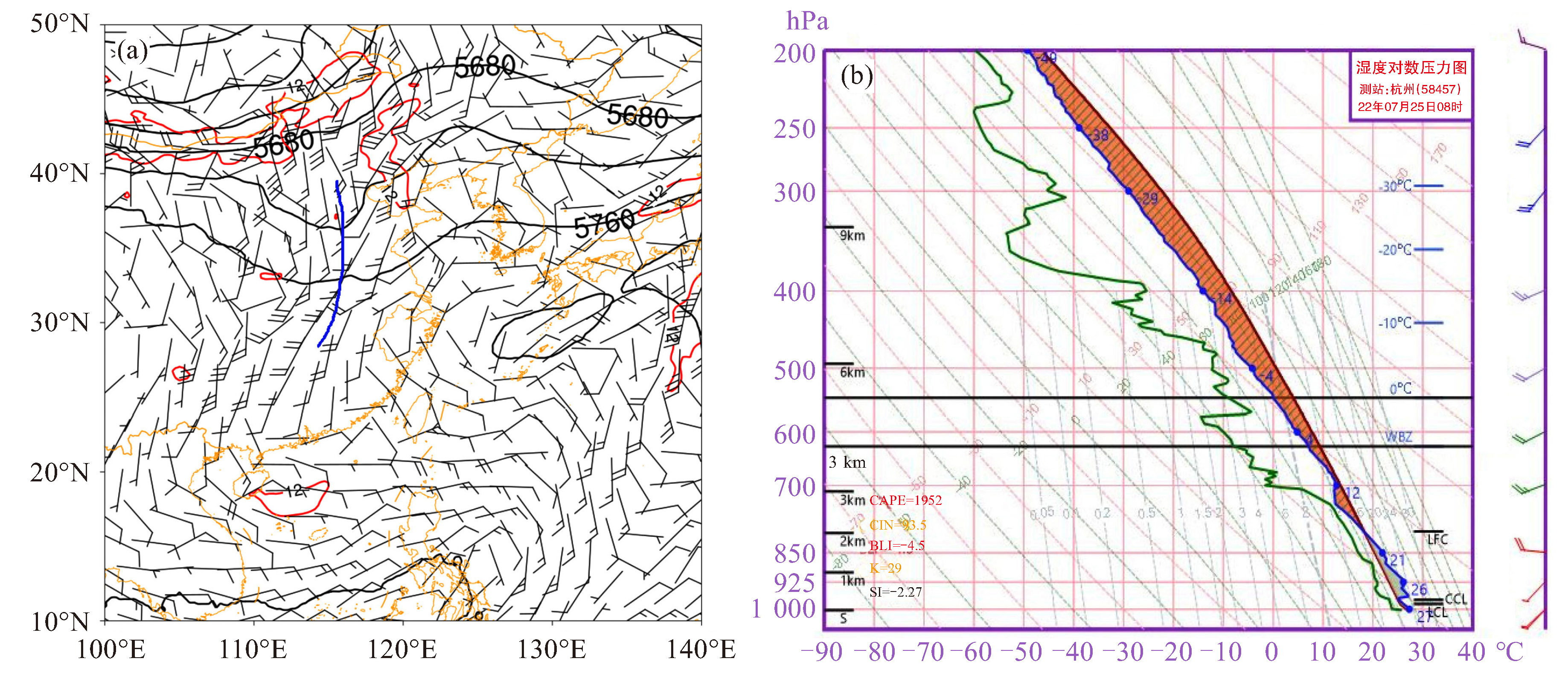
图 6 2022年7月25日14时500 hPa高度场(黑线,单位:gpm)、700 hPa急流(红线,单位:m·s-1)和850 hPa风场(单位:m·s-1)(a)以及14时杭州站T-lgp图(b)

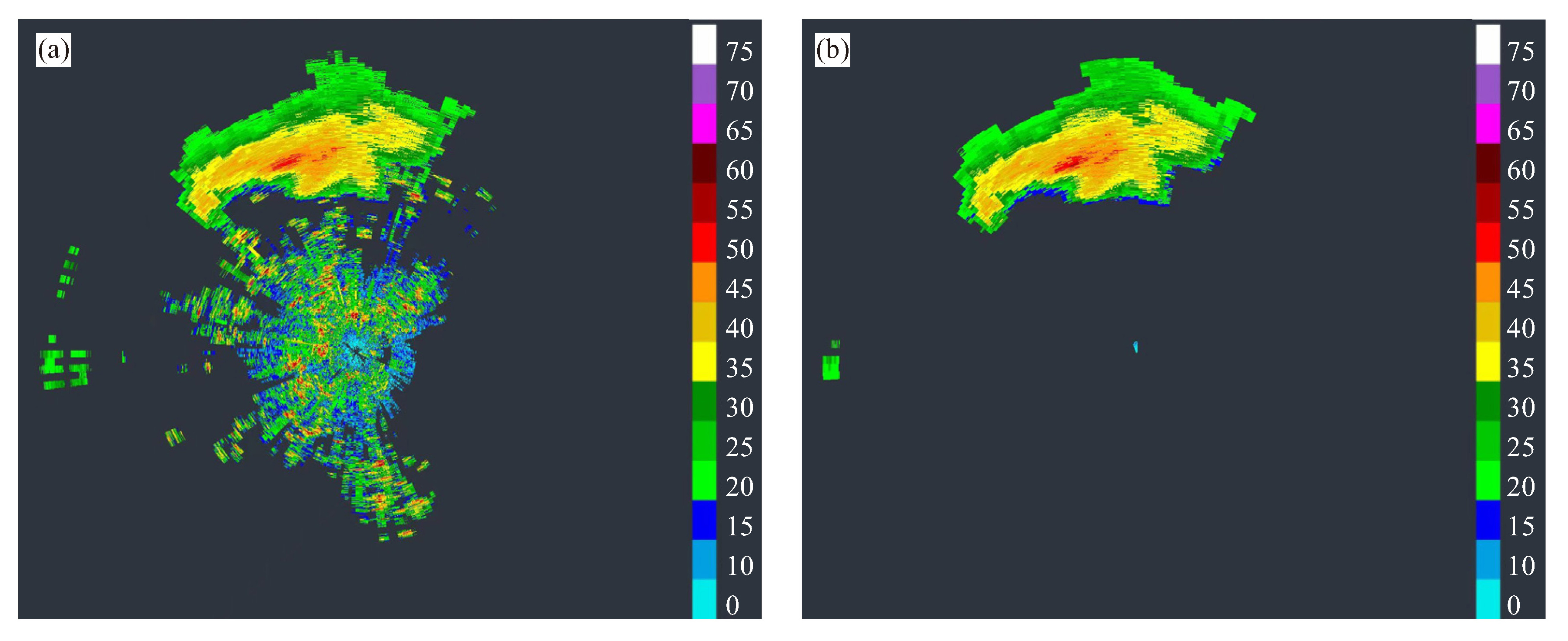
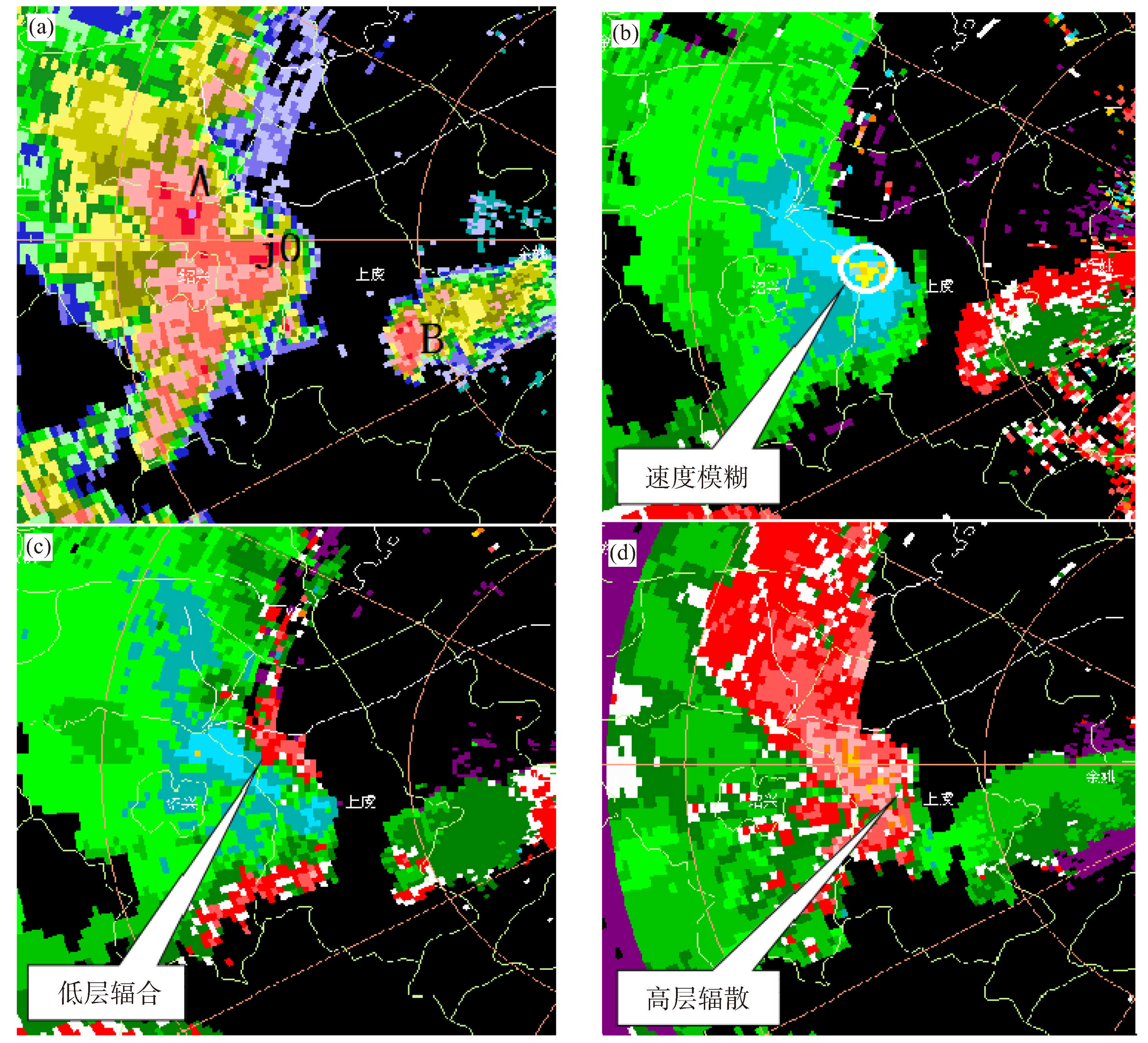
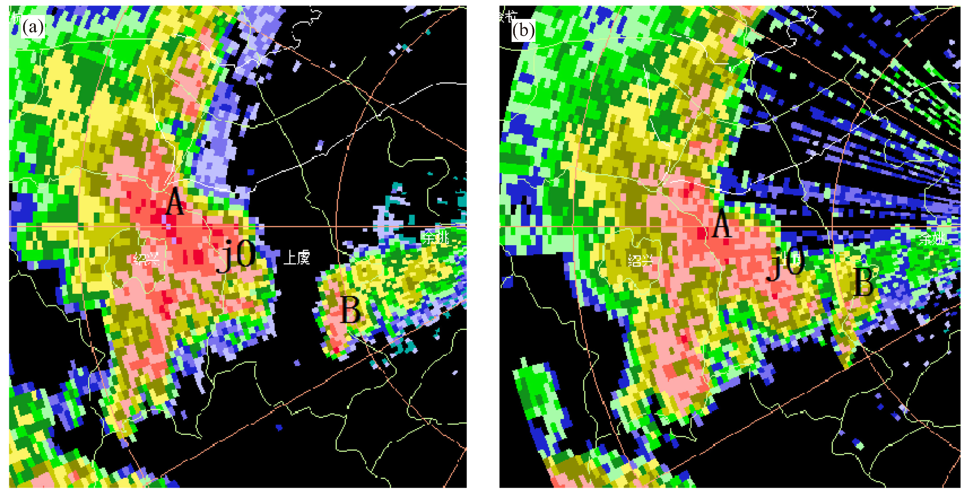
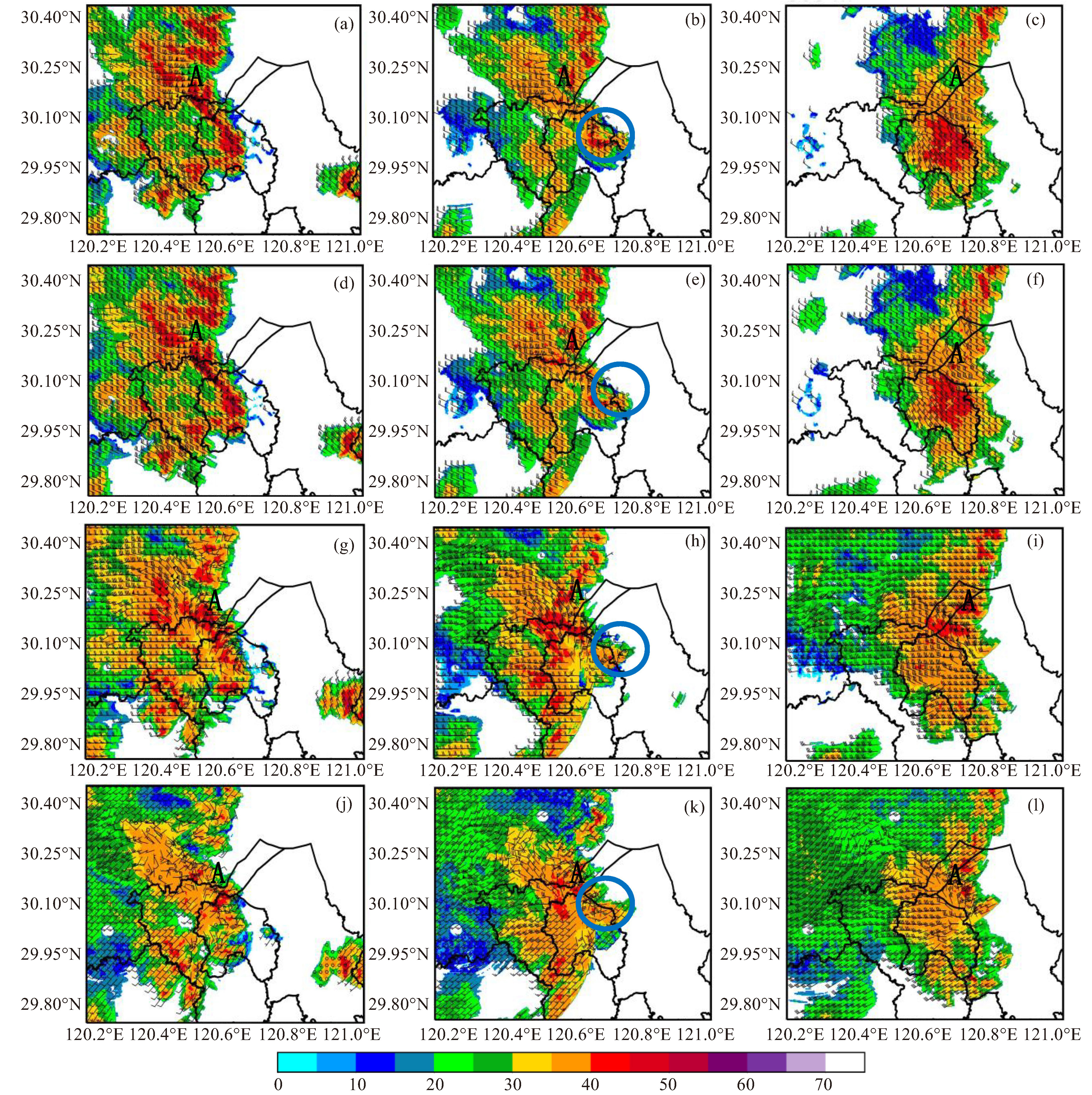
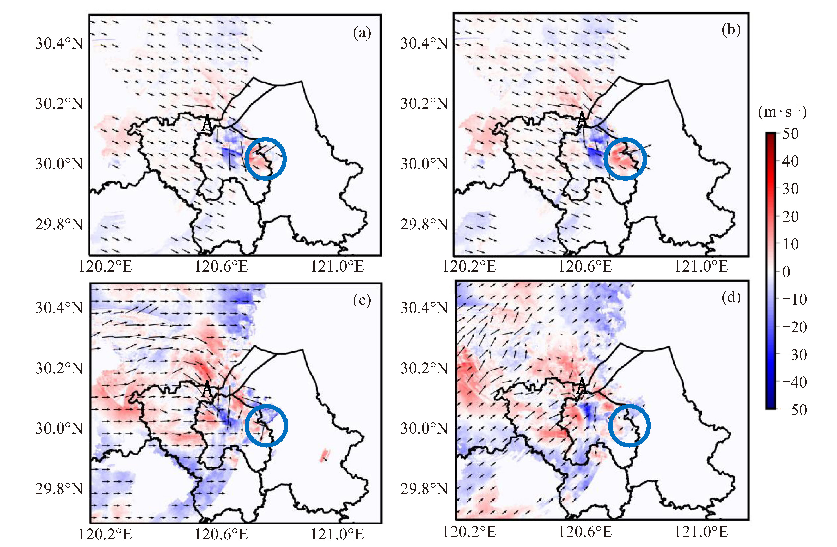
图 10 18:16(a、d、g、j)、18:30(b、e、h、k)、18:52(c、f、i、l)X波段相控阵雷达反射率因子叠加水平风场分布图
水平高度分别为600 m(a、b、c)、1 km(d、e、f)、3 km(g、h、i)、6 km(j、k、l),蓝色圈为单体J0。
表 1 S波段双偏振雷达和X波段相控阵雷达主要参数
参数名称 S波段双偏振雷达 X波段相控阵雷达 型号 CINRAD/SA-D ETWS-X02 工作频率/GHz 2.7~3.0 9.3~9.5 脉冲重复频率/Hz 300~1 300 2 857 脉冲宽度/μs 1.57 40 雷达波长/cm 10.9 3 极化方式 水平、垂直 水平、垂直 体扫模式 机械扫描 俯仰电扫、方位机械扫 体扫时间/s 360 60 探测仰角/° 0.5~19.5 0~72 径向分辨率/m 62.5~250.0 30 最大探测距离/km 460 60  下载: 导出CSV
-
[1] FUJITA T T. The Downburst, microburst and microburst[R]. SMRP Research Paper210, University of Chicago, 122. [2] ROBERTS R D, WILSON J W. A proposed microburst nowcasting procedure using single-Doppler radar[J]. J Appl Meteor, 1989, 28(4): 285-303. [3] EILTS M D, JOHNSON J T, MITEHELL E D, et al. Damaging downburst prediction and detection algorithm for the WSR-88D//18th Conference on Severe Local Storms[C]. San Francisco: American Meteorology Society, 1996: 541-545. [4] 吴海英, 孙继松, 慕瑞琪, 等. 一次强对流过程中两种不同类型风暴导致的极端对流大风分析[J]. 气象学报, 2023, 81(2): 205-217. [5] 康岚, 刘炜桦, 肖递祥, 等. 四川盆地一次极端大风天气过程成因及预报着眼点分析[J]. 气象, 2018, 44(11): 1 414-1 423. [6] 王婷婷, 朱文剑, 姚凯, 等. 2021年吉林中部以西极端雷暴大风的中尺度成因分析[J]. 气象, 2023, 49(10): 1 215-1 226. [7] 张曦, 黄兴友, 刘新安, 等. 北京大兴国际机场相控阵雷达强对流天气监测[J]. 应用气象学报, 2022, 33(2): 192-204. [8] 苏永彦, 刘黎平. S波段双偏振雷达和X波段相控阵雷达中气旋识别结果对比[J]. 气象, 2022, 48(2): 229-244. [9] 张羽, 吴少峰, 李浩文, 等. 广州X波段双偏振相控阵天气雷达数据质量初步分析及应用[J]. 热带气象学报, 2022, 38(1): 23-34. [10] 潘佳文, 彭婕, 魏鸣, 等. 副热带高压背景下极端短时强降水的双偏振相控阵雷达观测分析[J]. 气象学报, 2022, 80(5): 748-764. [11] 于明慧, 刘黎平, 吴翀, 等. 利用相控阵及双偏振雷达对2016年6月3日华南一次强对流过程的分析[J]. 气象, 2019, 45(3): 330-344. [12] 肖靖宇, 杨玲, 俞小鼎, 等. 佛山相控阵阵列雷达探测2020年9月4日短时强降水天气过程的分析[J]. 气象, 2022, 48(7): 826-839. [13] 马舒庆, 陈洪滨, 王国荣, 等. 阵列天气雷达设计与初步实现[J]. 应用气象学报, 2019, 30(1): 1-12. [14] BRINGI V N, CHANDRASEKER V. 偏振多普勒天气雷达原理和应用[M]. 北京: 气象出版社, 2010: 257-262. [15] CAREY L D, RUTLEDGE S A, AHIJEVYCH D A. Correcting propagation effects in C-Band polarimetric radar observations of tropical convection using differential propagation phase[J]. J Appl Meteor, 2000, 39: 1 405-1 433. [16] SIGGIA A D, PASSARELLI Jr R E. Gaussian model adaptive processing(GMAP)for improved ground clutter cancellation and moment calculation[C]//Proceedings of the 3rd European Conference on Radar in Meteorology. Visby, Sweden: ERAD, 2004: 67-73. [17] SHAPIRO A, POTVIN C K, GAO J. Use of a vertical vorticity equation in variational dual-Doppler wind analysis[J]. J Atmos Oceanic Technol, 2009, 26(10): 2 089-2 106. [18] POTVIN C K, SHAPIRO A, XUEM. Impact of a vertical vrticity constraint in variational dual-Doppler wind analysis: Tests with real and simulated supercell data[J]. J Atmos Oceanic Technol. 2012, 29(1): 32-49. [19] NORTH K W, OUE M, KOLLIAS P, et al. Vertical air motion retrievals in deep convective clouds using the ARM scanning radar network in Oklahoma during MC3E[J]. Atmos Meas Tech, 2017, 10(8): 2 785-2 806. [20] 李渝, 马舒庆, 杨玲, 等. 长沙机场阵列天气雷达风场验证[J]. 应用气象学报, 2020, 31(6): 1-13. [21] 许爱华, 孙继松, 许东蓓, 等. 中国中东部强对流天气的天气形势分类和基本要素配置特征[J]. 气象, 2014, 40(4): 400-411. [22] 樊李苗, 俞小鼎. 杭州地区夏季午后雷暴大风环境条件分析[J]. 气象, 2020, 46(12): 1 621-1 632. [23] 樊李苗, 俞小鼎. 中国短时强对流天气的若干环境参数特征分析[J]. 高原气象, 2013, 32(1): 156-165. [24] 俞小鼎, 张爱民, 郑媛媛, 等. 一次系列下击暴流事件的多普勒天气雷达分析[J]. 应用气象学报, 2006, 17(4): 385-393. [25] 俞小鼎, 周小刚, 王秀明. 雷暴与强对流临近天气预报技术进展[J]. 气象学报, 2012, 70(3): 311-377. [26] 李彩玲, 蔡康龙, 黄先香, 等. 桂林一次强下击暴流成因分析[J]. 气象, 2021, 47(2): 242-252. [27] 周后福, 刁秀广, 赵倩, 等. 一次连续下击暴流天气的成因分析[J]. 干旱气象, 2017, 35(4): 641-648. -


 点击查看大图
图(12) / 表(1)
计量
- 文章访问数: 7
- HTML全文浏览量: 2
- PDF下载量: 2
- 被引次数: 0
 粤公网安备 4401069904700003号