


Research on Quantitative Precipitation Estimation Using Dual-Polarization Radar Based on 3D Convolution
-
摘要: 强降水常常引发洪涝灾害,因此提高雷达定量降水估测(QPE)准确性对减轻灾害损失具有重要意义。利用广州双偏振雷达数据与自动站雨量数据生成四维数据集,设计了3DPoly-QPENet、3DTime-QPENet、3DEcho-QPENet三种三维卷积QPE模型进行比较试验。通过测试集的性能评估和典型暴雨个例的检验,得出以下结论:(1)四维数据集相较于传统的三维数据集,在捕捉降水分布特征和提升QPE拟合效果方面提供了更多的可能性;(2)三种三维卷积QPE模型呈现出与结构设计紧密相关的性能差异,其中3DPoly-QPENet在中等降水量区间(15~20 mm·h-1)的平均绝对误差(MAE)较另两种模型平均降低13%;3DTime-QPENet在高降水量事件(>50 mm·h-1)的MAE较另两种模型平均降低8.1%;3DEcho-QPENet全局误差均衡性最优,总体MAE较另两种模型平均降低20.4%;(3)三维卷积模型均系统性优于传统Z-R关系方法,平均RMSE降低46.6%,MAE下降48.6%,CC提升21.4%。Abstract: Heavy precipitation often triggers flooding disasters. Therefore, enhancing radar-based quantitative precipitation estimation(QPE) accuracy is critical for disaster mitigation. This study employs Guangzhou dual-polarization radar data and automatic weather station rainfall data to construct a four-dimensional dataset. Three three-dimensional convolutional QPE models—namely, 3DPoly-QPENet, 3DTime-QPENet, and 3DEcho-QPENet—were designed and evaluated through comparative experiments. Based on test-set performance assessments and validation with typical heavy rainfall cases, we draw the following condusions: (1) Compared to traditional three-dimensional datasets, the four-dimensional dataset better captures precipitation distribution characteristics and improves QPE fitting accuracy. (2) The three three-dimensional convolutional QPE models exhibit performance differences tied to their structural designs. Specifically, 3DPoly-QPENet reduces the mean absolute error (MAE) by an average of 13% in moderate precipitation (15-20 mm · h-1) compared to the other two models. 3DTime-QPENet achieves an average MAE reduction of 8.1% in high-intensity precipitation events (>50 mm · h-1). 3DEcho-QPENet shows the best global error balance, with an overall MAE reduction of 20.4% on average. (3) All three three-dimensional convolutional models surpass the traditional Z-R relationship method, reducing the root mean square error (RMSE) by an average of 46.6%, lowering MAE by 48.6%, and increasing the correlation coefficient (CC) by 21.4%.
-

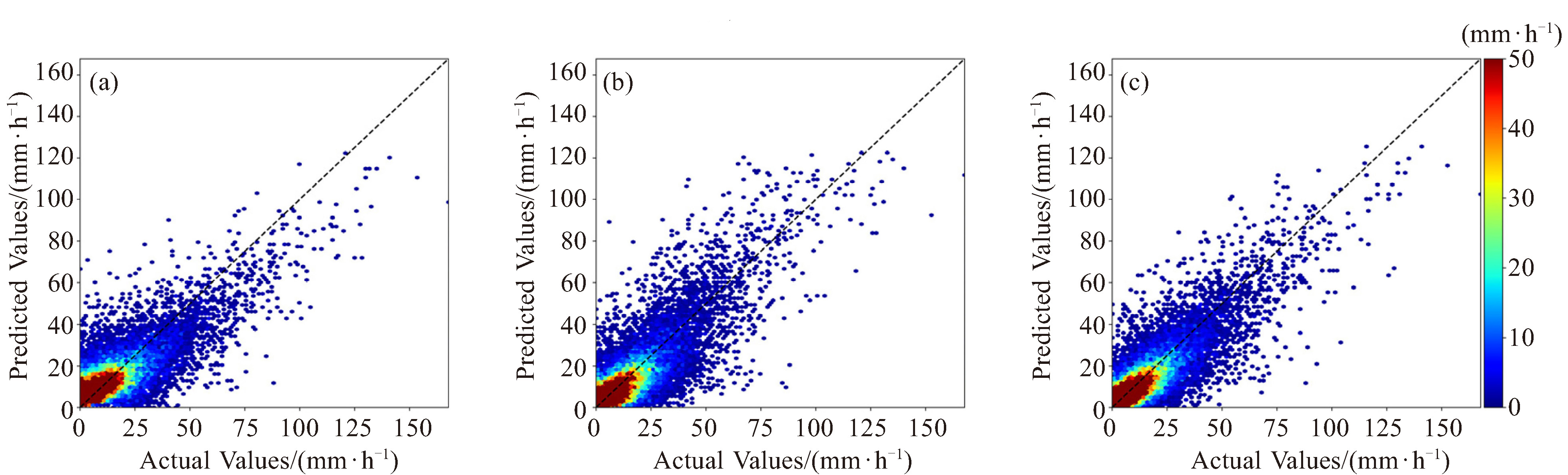
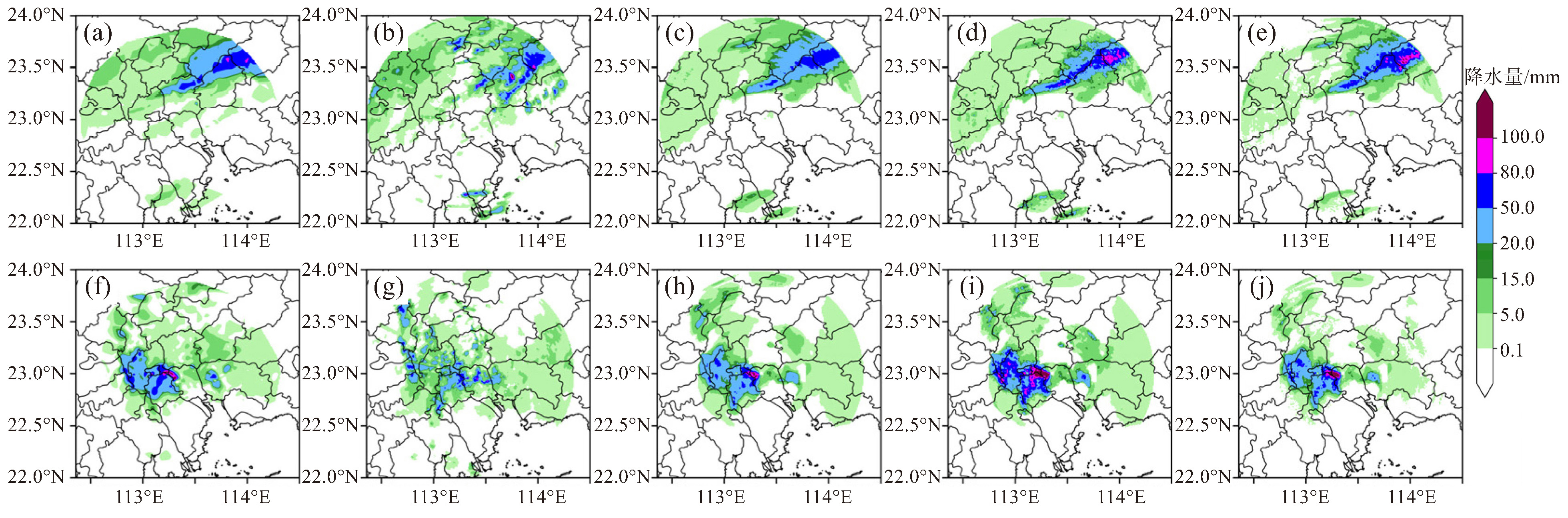
图 6 北京时间2022年6月14日09:00降水个例
图a为观测的降水场、图b为Z-R关系估测降水、图c为3DPoly-QPENet模型估测降水、图d为3DTime-QPENet模型估测降水、图e为3DEcho-QPENet模型估测降水)及北京时间2022年9月8日19:00降水个例(图f为观测的降水场、图g为Z-R关系估测降水、图h为3DPoly-QPENet模型估测降水、图i为3DTimeQPENet模型估测降水、图j为3DEcho-QPENet模型估测降水
表 1 模型预测结果评估指标对比
模型 雨量等级/(mm·h-1) RE/% MAE/mm RMSE/mm Bias CC R2 3DPoly-QPENet Total 58.03 2.840 4.696 1.260 0.852 0.711 0.1~5 56.24 2.110 2.911 2.051 5~15 34.71 3.598 5.430 1.008 15~20 38.29 5.729 7.227 -2.430 20~50 49.89 10.604 12.923 -8.274 >50 37.79 19.554 23.345 -18.097 3DTime-QPENet Total 38.28 1.956 4.331 -0.089 0.869 0.748 0.1~5 35.94 0.937 1.841 0.567 5~15 49.38 4.004 5.516 -1.043 15~20 49.09 6.773 8.452 -3.178 20~50 46.42 10.778 13.525 -5.371 >50 31.58 16.859 21.861 -6.650 3DEcho-QPENet Total 34.91 1.847 4.018 -0.082 0.885 0.783 0.1~5 32.99 0.924 1.729 0.048 5~15 43.79 3.660 5.134 -0.647 15~20 44.61 6.317 7.918 -3.085 20~50 41.53 9.633 12.037 -5.824 >50 32.62 17.223 21.882 -12.898  下载: 导出CSV
表 2 不同雷达定量降水估测方法对比
时间 降水估测方法 RE/% MAE/mm RMSE/mm Bias CC 2022年6月14日09:00(BJT) Z-R关系 66.14 8.541 14.528 -1.572 0.730 3DPoly-QPENet 37.73 3.703 6.710 -1.121 0.913 3DTime-QPENet 51.75 5.131 8.414 -1.647 0.867 3DEcho-QPENet 41.03 4.068 7.279 -1.462 0.908 2022年9月8日19:00(BJT) Z-R关系 61.82 7.967 14.398 -1.654 0.728 3DPoly-QPENet 48.23 4.185 7.374 -0.599 0.884 3DTime-QPENet 52.03 5.383 9.243 1.122 0.870 3DEcho-QPENet 47.80 4.148 7.308 -0.617 0.886
下载: 导出CSV
-
[1] MARSHALL J S, PALMER W Mc K. The distribution of raindrops with size[J]. J Atmos Sci, 1948, 5(4): 165-166. [2] NAYAK D R, MAHAPATRA A, MISHRA P. A survey on rainfall prediction using artificial neural network[J]. Int J Comput Appl, 2013, 72 (16): 32-40. [3] DARJI M P, DABHI V K, PRAJAPATI H B. Rainfall forecasting using neural network: A survey[C]//2015 International Conference on Advances in Computer Engineering and Applications. Ghaziabad: IEEE. 2015: 706-713. [4] WEI T, LEI Y, LIU W, et al. Ground radar precipitation estimation with deep learning approaches in meteorological private cloud[J]. J Cloud Comput, 2020, 9(1): 1-12. [5] RUMELHART D E, HINTON G E, WILLIAMS R J. Learning representations by back-propagating errors[M]//Neurocomputing: Foundations of Research. Cambridge: MIT Press, 1988: 696-699. [6] 皇甫江, 胡志群, 郑佳锋, 等. 利用深度学习开展偏振雷达定量降水估测研究[J]. 气象学报, 2022, 80(4): 565-577. [7] 蔡康龙, 胡志群, 谭浩波, 等. 利用卷积神经网络开展偏振雷达定量降水估测研究[J]. 热带气象学报, 2024, 40(1): 64-74. [8] 张永华. 基于深度学习的华南登陆台风偏振雷达定量降水估测研究[D]. 南京: 南京信息工程大学, 2022. [9] PENG X, LI Q, JING J. CNGAT: A graph neural network model for radar quantitative precipitation estimation[J]. IEEE Trans Geosci Remote Sens, 2021, 60(1): 1-14. [10] 郑玉, 魏鸣, 李南. 基于循环神经网络改进雷达定量估测强降水[J]. 中国科技论文, 2020, 15(5): 585-592. [11] TANG Y, YANG X, ZHANG W, et al. Radar and rain gauge merging-based precipitation estimation via geographical-temporal attention continuous conditional random field[J]. IEEE Trans Geosci Remote Sens, 2018, 56(9): 5135-5146. [12] MORAUX A, DEWITTES S, Cornelis B, et al. A deep learning multimodal method for precipitation estimation[J]. Remote Sens, 2021, 13 (16): 3278. [13] GAVAHI K, FOROUMAND E, MORADKHANI H. A deep learning-based framework for multi-source precipitation fusion[J]. Remote Sens Environ, 2023, 295: 113723. [14] WANG L. Improving radar quantitative precipitation estimation through optimizing radar scan strategy and deep learning[D]. Colorado: Colorado State University, 2024. [15] KIM Y, HONG S. Very short-term prediction of weather radar-based rainfall distribution and intensity over the Korean peninsula using convolutional long short-term memory network[J]. Asia-Pac J Atmos Sci, 2022, 58(4): 489-506. [16] MA Y, CHANDRASEKAR V, BISWASi S K. A Bayesian correction approach for improving dual-frequency precipitation radar rainfall rate estimates[J]. J Meteor Soc Japan Ser Ⅱ, 2020, 98(3): 511-525. [17] 易雷. 基于时空预测网络和卷积神经网络的短临降水预测研究[D]. 南京: 南京信息工程大学, 2022. [18] TRAN D, BOURDEV L, FERGUS R, et al. Learning spatiotemporal features with 3d convolutional networks[C]//Proceedings of the IEEE international conference on computer vision. Santiago: IEEE, 2015: 4489-4497. [19] RONNEBERGER O, FISCHER P, BROX T. U-net: Convolutional networks for biomedical image segmentation[C]//Medical image computing and computer-assisted intervention-MICCAI 2015: 18th international conference. Munich: Springer International Publishing, 2015: 234-241. [20] ÇIÇEK Ö, ABDULKADIR A, LIENKAMP SS, et al. 3D U-Net: learning dense volumetric segmentation from sparse annotation[C]//Medical Image Computing and Computer-Assisted Intervention-MICCAI 2016: 19th International Conference, Athens: Springer International Publishing, 2016. [21] ZHANG Y, LIU L, BI S, et al. Analysis of dual-polarimetric radar variables and quantitative precipitation estimators for landfall typhoons and squall lines based on disdrometer data in southern China[J]. Atmosphere, 2019, 10(1): 30. [22] GABELLA M, NOTARPIETRO R. Ground clutter characterization and elimination in mountainous terrain[C]//Proceedings of ERAD. 2002, 305(311). [23] HELMUS J J, COLLIS S M. The Python ARM Radar Toolkit(Py-ART), a library for working with weather radar data in the Python programming language[J]. J Open Res Softw, 2016, 4. [24] ZHANG Y, BI S, LIU L, et al. Deep learning for polarimetric radar quantitative precipitation estimation during landfalling typhoons in South China[J]. Remote Sens, 2021, 13(16): 3157. [25] NEYMAN J. On the two different aspects of the representative method: the method of stratified sampling and the method of purposive selection[M]//Breakthroughs in statistics: Methodology and distribution. NY: Springer New York, 1992: 123-150. [26] REN J, YU C, MA K, et al. Balanced MSE for Imbalanced Visual Regression[C]//Proceedings of the IEEE/CVF Conference on Computer Vision and Pattern Recognition, 2022: 4175-4184. [27] LEGATES D R. Rea-time calibration of radar precipitation estimates[J]. Prof Geogr, 2000, 52(2): 235-246. [28] 高烽, 周新尧, 孔凡超, 等. 滑动时间窗长度对太行山区雷达反演降水的影响[J]. 气象, 2018, 44(4): 538-547. -

 点击查看大图
图(6) / 表(2)
计量
- 文章访问数: 10
- HTML全文浏览量: 0
- PDF下载量: 4
- 被引次数: 0
 粤公网安备 4401069904700003号