


Analysis of the Environmental Parameters of Warm-sector Heavy Rainfall in Different Types in Guangdong Province During Rainy Season in Recent 10 Years
-
摘要: 利用广东省国家基本气象站、区域自动站雨量数据和ERA5再分析资料,将2013—2022年近10年73次典型的广东暖区暴雨个例按环流特征分为四种类型:切变线型、低涡型、南风型和回流型,统计分析时空分布特征以及表征大气静力不稳定、水汽、能量和动力条件的物理量特征。(1)广东暖区暴雨中南风型发生频率最高,回流型最低。67%的暖区暴雨发生在5—6月,降水峰值时间95%出现在凌晨和白天,其中南风型特征最明显,72%出现在早晨05—08时和午后12—17时。(2)不同类型暖区暴雨空间分布差异较大,回流型暖区暴雨降水中心为珠江口西侧,不同于其他三种类型均有2个主要落区。(3)不同类型暖区暴雨发生的关键环境参数表明,各种类型的暖区暴雨发生均不需要强的条件不稳定,500 hPa和850 hPa温差阈值仅在22 ℃左右;均需要充沛的水汽条件,其中回流型大气可降水量阈值最低,但仍达52 mm;能量条件和动力条件不同类型阈值差异较大,回流型暖区暴雨所需的能量条件、低层风速更弱,但0~6km深层垂直风切变更强。Abstract: Based on the rainfall data of Guangdong National basic meteorological Stations, regional automatic stations and NCEP FNL reanalysis data, 73 typical warm-sector heavy rainfall cases in Guangdong during 2013-2022 were divided into four types according to circulation characteristics. They are shear line, low vortex, southerly wind, and backflow types. The characteristics of spatiotemporal distribution and physical quantities representing atmospheric static instability, energy, water vapor and dynamic conditions were analyzed statistically. The main results are as follows: (1) The southerly wind type has the highest frequency, and the backflow type has the lowest frequency. 67% of the warm-sector heavy rainfalls occur during May-June, with 95% of the peak precipitation time occurring in the early morning and daytime. The southerly wind type shows the most distinct variation, with 72% of cases occurring from 05: 00 to 08: 00 in the morning and 12: 00 to 17: 00 in the afternoon. (2) The spatial distribution of warm-sector heavy rainfall shows significant differences among different types. The center of the backflow type warm-sector heavy rainfall is located on the western side of the Pearl River Estuary, which differs from the other three types with two main precipitation zones. (3) The key environmental parameters different types of warm-sector heavy rainfall indicate that none of the types require strong conditional instability, and the temperature difference threshold between 500 hPa and 850 hPa is only about 22 ℃. All of them need abundant water vapor, with the precipitable water threshold for the backflow type being the lowest (50 mm). Significant differences exist in energy and dynamic condition thresholds among 4 types. The backflow type requires weaker energy conditions and lower-tropospheric wind speeds, but stronger vertical wind shear from surface to 6 km.
-

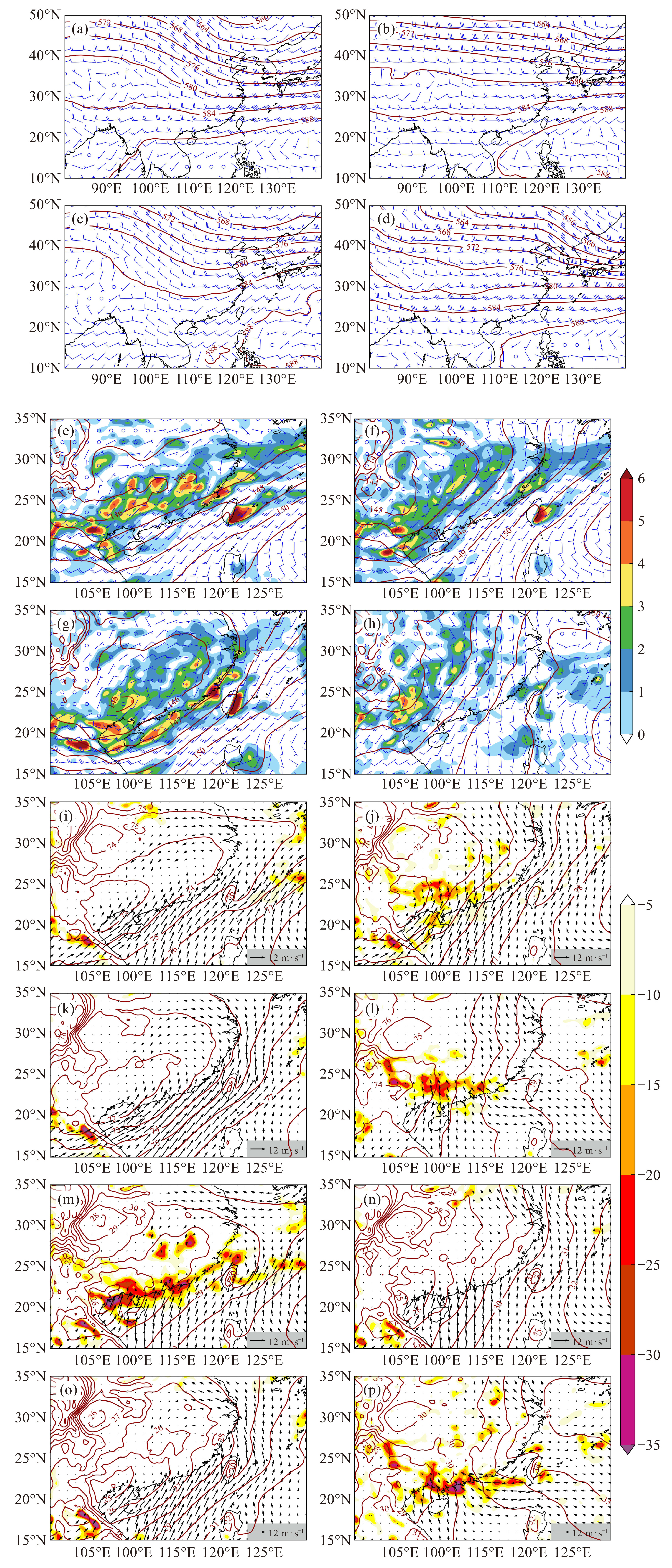
图 2 2013—2022年4—9月广东省切变线型(a, e, i, m)、南风型(b, f, j, n)、低涡型(c, g, h, o)、回流型(d, h, l, p)暖区暴雨合成环流形势
(a, b, c, d)500 hPa风场(风杆,单位:m·s-1),位势高度场(暗红色实线,单位:dagpm);(e, f, g, h)850 hPa风场(风杆,单位:m·s-1),位势高度场(暗红色实线,单位:dagpm),正涡度区(填色,单位:10-5 s-1);(i, j, k, l)925 hPa和(m, n, o, p)975 hPa风场(黑色箭头,单位:m·s-1),散度场(填色,单位:10-6 s-1),位势高度场(暗红色实线,单位:dagpm)。

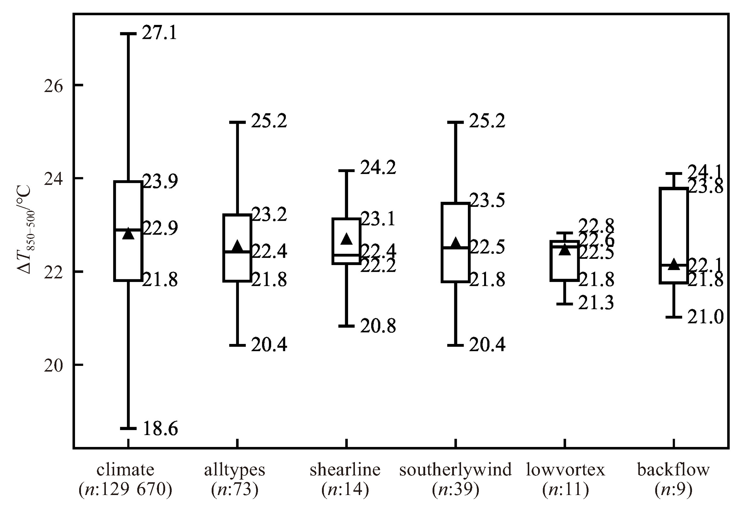
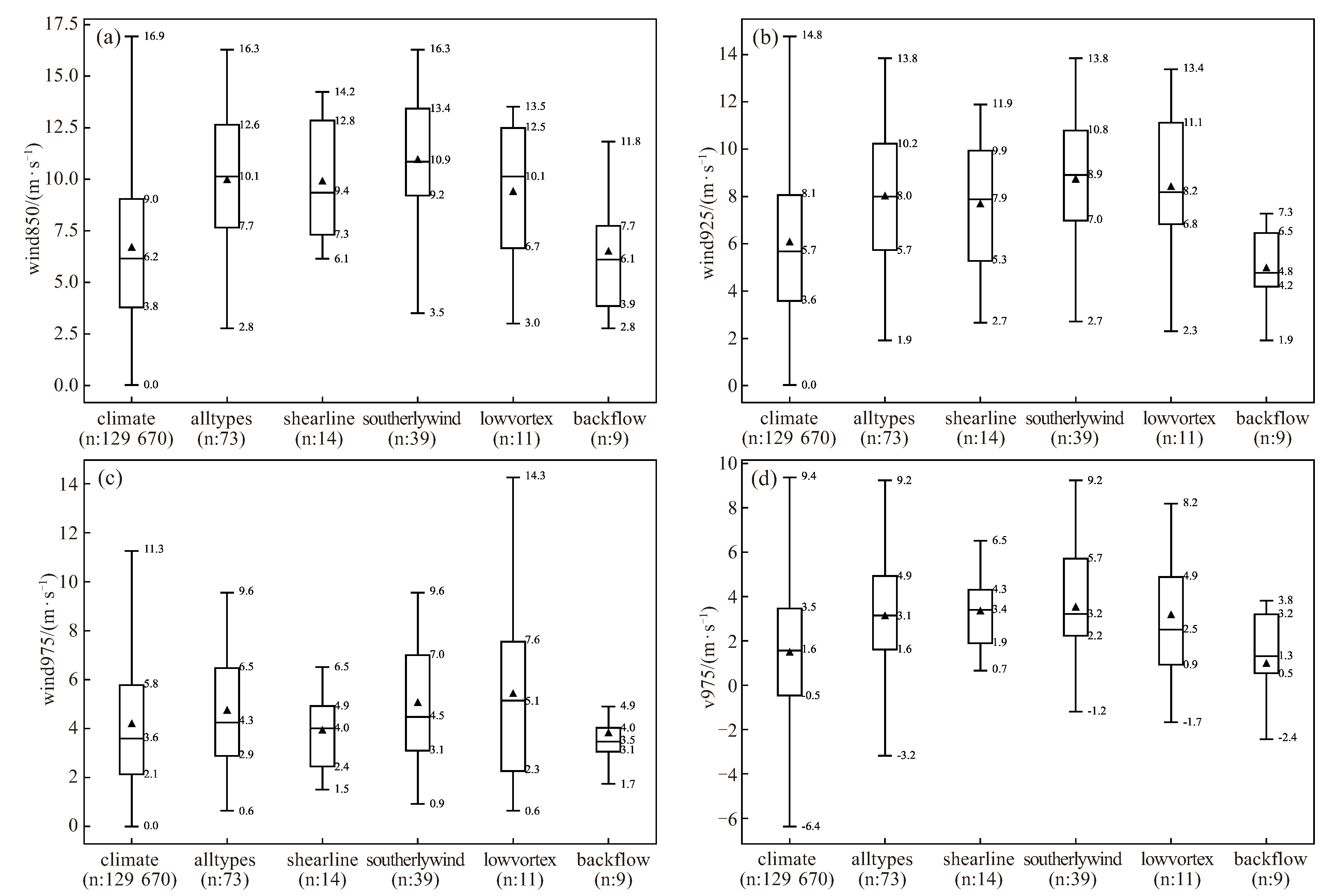
图 6 不同类型暖区暴雨和气候态500 hPa和850 hPa温差箱线图
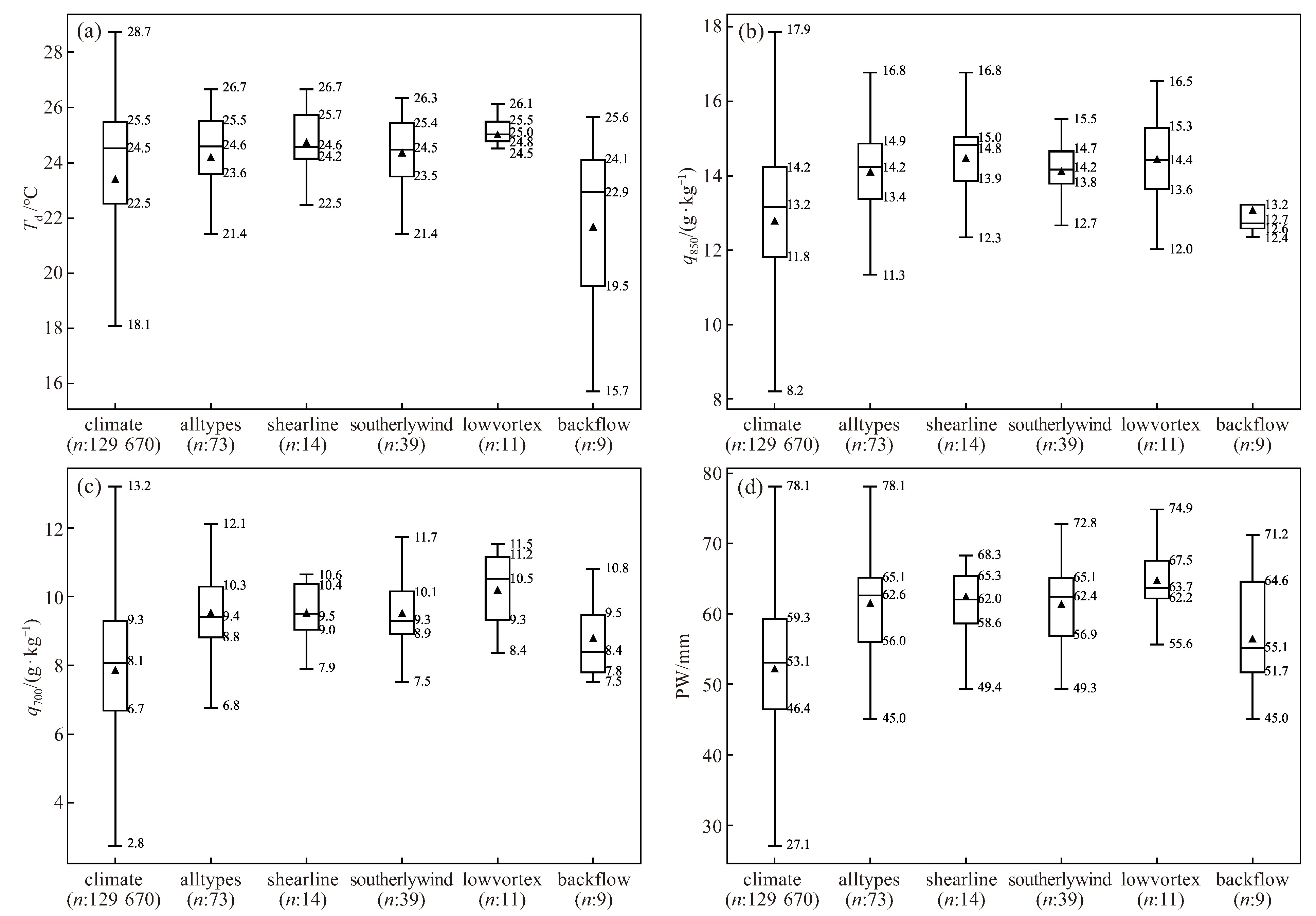
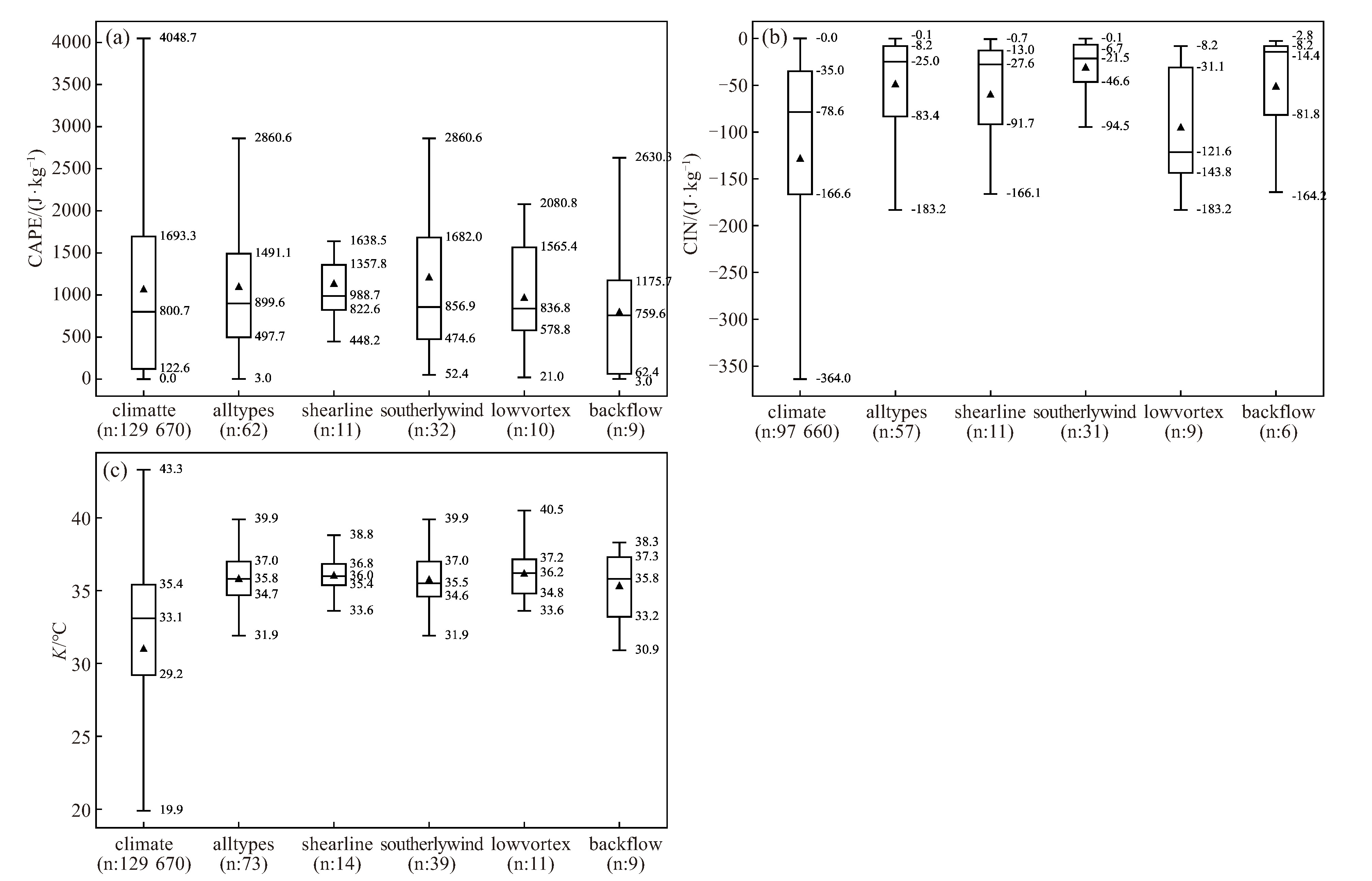
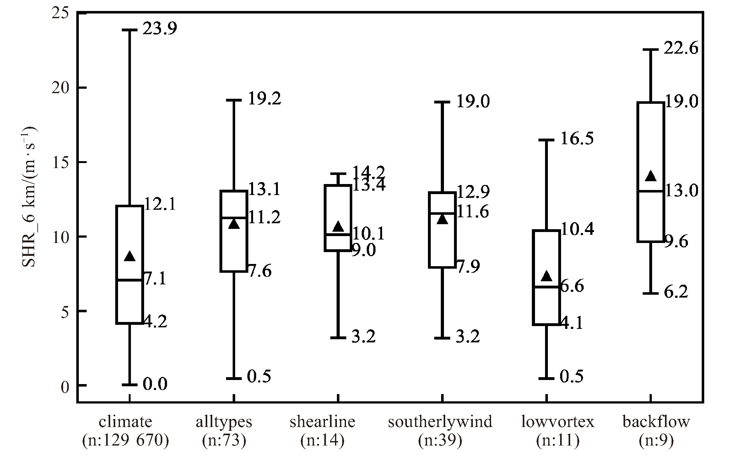
上框线:75百分位数;下框线:25百分位数;箱内线:中位数;实心三角形:均值;上边缘线:极大值,≤(75百分位数+1.5×四分位距);下边缘线:极小值,≥(25百分位数-1.5×四分位距),下同。n为样本数。
表 1 广东暖区暴雨环境参量预报阈值表
环境参量 全部暖区暴雨 切变线型 南风型 低涡型 回流型 ΔT350-500 ℃ 21.8 22.2 21.8 21.8 21.8 Td ℃ 23.6 24.2 23.5 24.8 19.5 q850 (g·kg-1) 13.4 13.9 13.8 13.6 12.6 q700 (g·kg-1) 8.8 9 8.9 9.3 7.8 PW/mm 56 59 57 62 52 CAPE/(J·kg-1) 498 823 475 579 62 CIN/(J·kg-1) -83 -92 -47 -144 -82 K/℃ 35 35 35 35 33 SHR6km / (m·s-1) 7.6 9 7.9 4.1 9.6 wind850hPa/(m·s-1) 7.7 7.3 9.2 6.7 3.9 wind925hPa/(m·s-1) 5.7 5.3 7 6.8 4.2 v975hPa/(m·s-1) 1.6 1.9 2.2 0.9 0.5  下载: 导出CSV
-
[1] 黄士松, 李真光, 包澄澜, 等. 华南前汛期暴雨[M]. 广州: 广东科技出版社, 1986: 55-100. [2] 林良勋. 广东省天气预报技术手册[M]. 北京: 气象出版社, 2006: 143-152. [3] 吴乃庚, 温之平, 邓文剑, 等. 华南前汛期暖区暴雨研究新进展[J]. 气象科学, 2020, 40(5): 605-616. [4] 何立富, 陈涛, 孔期. 华南暖区暴雨研究进展[J]. 应用气象学报, 2016, 27(5): 559-569. [5] 陈绍河, 郑凤琴, 蔡悦幸, 等. 广西防城港沿海6·16特大暴雨成因及机制探讨[J]. 热带气象学报, 2023, 39(4): 433-442. [6] 梁钟清, 张艳霞, 钟水新, 等. 地形对一次粤北暖区暴雨的影响研究[J]. 热带气象学报, 2023, 39(4): 536-550. [7] SUN J H, ZHANG Y C, LIU R X, et al. A review of research on warm-sector heavy rainfall in China[J]. Adv Atmos Sci, 2019, 36(12): 1299 -1307. [8] 刘瑞鑫, 孙建华, 陈鲍发. 华南暖区暴雨事件的筛选与分类研究[J]. 大气科学, 2019, 43(1): 119-130. [9] DU Y, CHEN G. Heavy rainfall associated with double lowlevel jets over southern China. Part Ⅱ: convection initiation[J]. Mon Wea Rev, 2019, 147(2): 543-565. [10] ZHOU X, CHENG Z, LI H, et al. Comparison between the roles of Low-Level Jets in two heavy rainfall events over South China[J]. J Meteor Res Japan, 2022, 36(2): 326-341. [11] 丁治英, 刘彩虹, 沈新勇. 2005-2008年5、6月华南暖区暴雨与高、低空急流和南亚高压关系的统计分析[J]. 热带气象学报, 2011, 27 (3): 307-316. [12] WU N, DING X, WEN Z, et al. Contrasting frontal and warm-sector heavy rainfalls over South China during the early summer rainy season[J]. Atmos Res, 2020, 235: 104693. [13] 付炜, 唐明晖, 叶成志, 等. 强西南急流背景下南岭山脉一次暖区大暴雨数值模拟分析[J]. 热带气象学报, 2022, 38(2): 203-215. [14] 陈芳丽, 刘显通, 曾丹丹, 等. 珠三角北部一次暖区强降水过程中的地形作用[J]. 热带气象学报, 2022, 38(3): 377-386. [15] 覃武, 刘国忠, 赖珍权, 等. 华南暖区暴雨预报失误及可预报性探讨[J]. 气象, 2020, 46(8): 1039-1052. [16] 徐明, 黄治勇, 高琦. 2016年5月20日广东信宜特大暴雨中尺度对流系统特征分析[J]. 暴雨灾害, 2018, 37(1): 32-40. [17] 罗娟, 邓承之, 高松, 等. 武陵山区一次暖区强降水触发和维持机制分析[J]. 热带气象学报, 2022, 38(5): 754-766. [18] 汪汇洁, 孙建华, 卫捷, 等. 近30年我国南方区域持续性暴雨过程的分类研究[J]. 气候与环境研究, 2014, 19(6): 713-725. [19] 高晓梅, 俞小鼎, 王令军, 等. 鲁中地区分类强对流天气环境参量特征分析[J]. 气象学报, 2018, 76(2): 196-212. [20] 万轶婧, 王东海, 梁钊明, 等. 华南暖区暴雨环境参量的统计分析[J]. 中山大学学报(自然科学版), 2020, 59(6): 51-63. [21] JOHNS R H, DOSWELL C A. Severe local storms forecasting[J]. Weather Forecasting, 1992, 7(4): 588-612. [22] 俞小鼎, 周小刚, 王秀明. 雷暴与强对流临近天气预报技术进展[J]. 气象学报, 2012, 70(3): 311-337. [23] 陈元昭, 俞小鼎, 陈训来. 珠江三角洲地区重大短时强降水的基本流型与环境参量特征[J]. 气象, 2016, 42(2): 144-155. [24] WEISMAN M L, KLEMO J B. The dependence of numerically simulated convective storms on vertical wind shear and buoyancy[J]. Mon Wea Rev, 1982, 110(6): 504-520. [25] MARKOWSHI P, RICHARDSON Y. Mesoscale Meteorology in Midlatitudes[M]. UK: WileyBlackwell, 2010. [26] 俞小鼎, 姚秀萍, 熊廷南, 等. 多普勒天气雷达原理与业务应用[M]. 北京: 气象出版社, 2006: 314. [27] 蒲义良, 卢栩诗, 胡胜, 等. 华南沿海一次暖区特大暴雨的对流特征和发展机制分析[J]. 气象, 2023, 49(2): 201-212. -

 点击查看大图
图(10) / 表(1)
计量
- 文章访问数: 4
- HTML全文浏览量: 0
- PDF下载量: 1
- 被引次数: 0
 粤公网安备 4401069904700003号