


Circulation Characteristics of Torrential Rain in Eastern Guangdong Caused by Typhoons Landing in Fujian
-
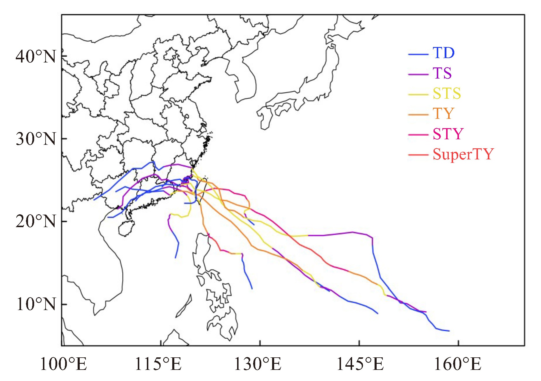
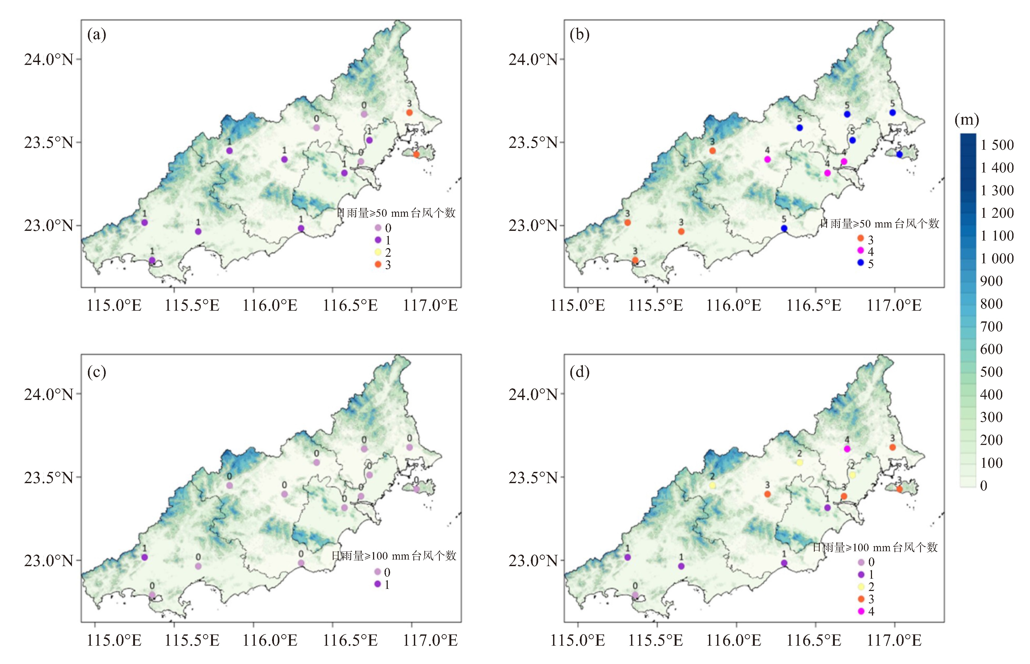
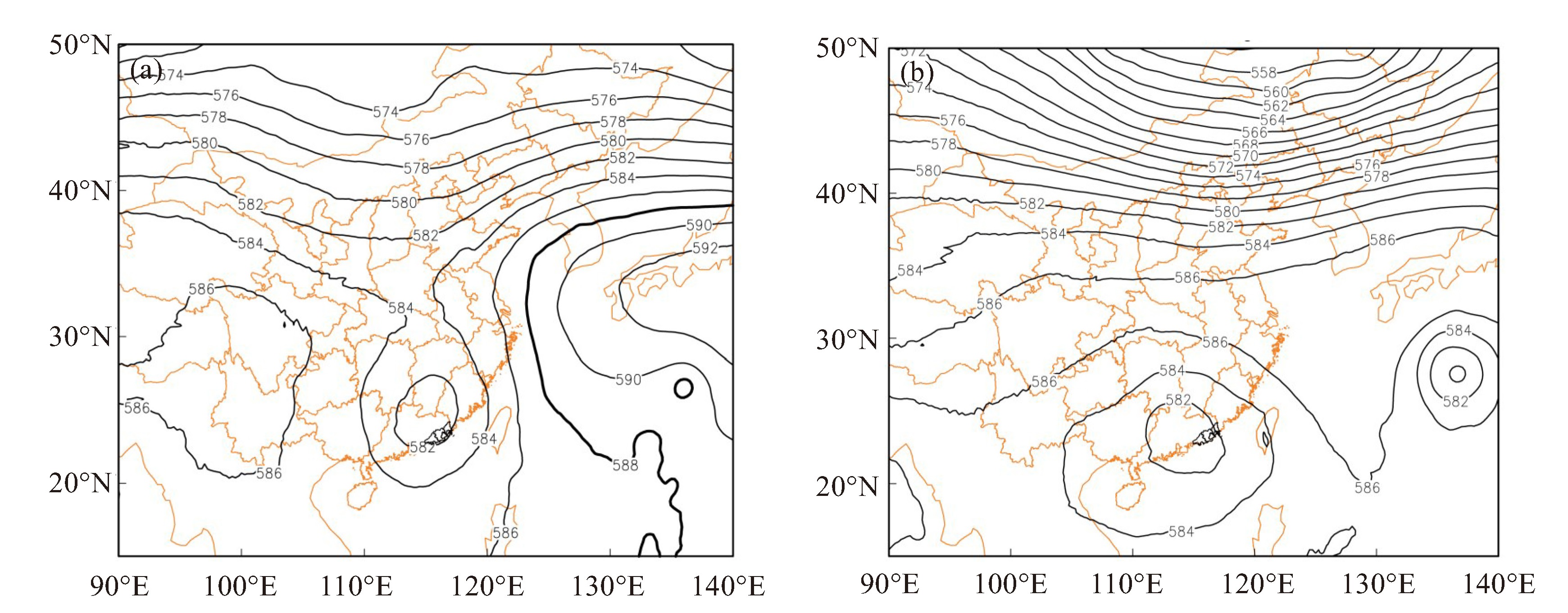
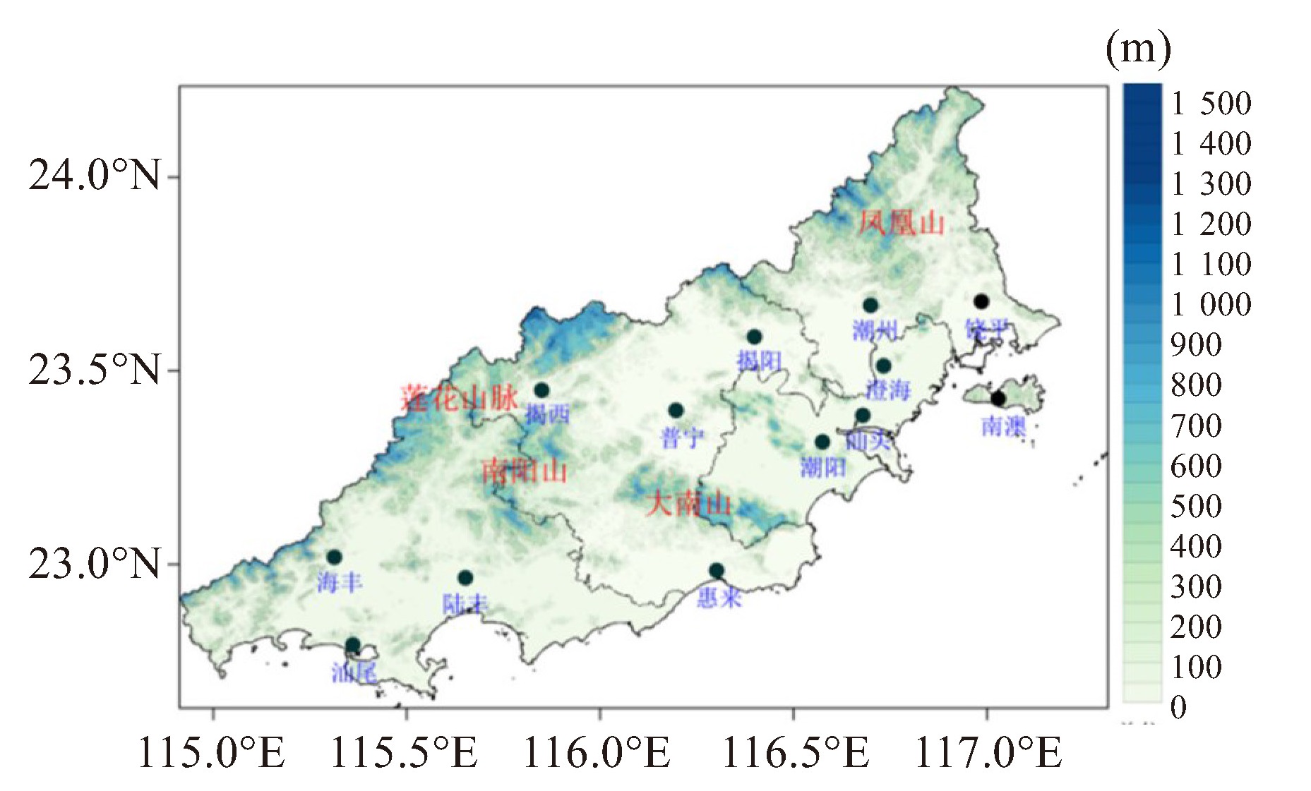
摘要: 使用中国气象局1990—2019年《热带气旋年鉴》、ERA5 0.25 °×0.25 °逐小时再分析资料、粤东地区国家气象站24小时(20—20时)日雨量,利用统计分型和合成分析方法对登陆福建后西行路径台风对粤东造成暴雨的环流特征进行分类统计,结果表明:台风登陆后一天导致的暴雨频次较登陆当天更高。中层处在强盛的副高边缘是出现暴雨的有利形势。将粤东是否出现暴雨的低层风场特征分为三类,一是台风槽型,降水持续时间较长;二是西南急流型,此类多于急流上岸时开始影响,急流强度越强,暴雨强度越大;三是东南气流型,此类型暴雨强度与地形有密切关系,山脉的迎风坡对暴雨起到增幅作用;弱降水台风主要是本体环流较弱,难以造成强降水。分析造成强弱降水台风的物理量配置特征,发现强降水台风的各种条件均明显优于弱降水台风。西南急流型的暖湿条件最好,即便动力条件一般,也能造成大范围的暴雨;台风槽型和东南急流型的动力条件最好,热力条件稍差,超过100 mm的强降水区域与高层辐散中心有很好的对应关系。在分析水汽条件时,当台风环流的东西方向水汽输送较强时,更有利于粤东地区的水汽输送;同时需注意是否有其他正在发展的热带系统,有可能会削弱或截断水汽的输送。Abstract: Using the Yearbook of Tropical Cyclone (1990-2019) from the China Meteorological Administration, ERA5 0.25 ° × 0.25 ° hourly reanalysis data, and 24-hour (20: 00-20: 00) rainfall observations from national stations in eastern Guangdong, this study classifies and analyzes the circulation characteristics of torrential rain in eastern Guangdong induced by westward-moving typhoons after landfall in Fujian Province. Statistical classification and composite analysis methods are employed. Results show that torrential rain occurs more frequently on the day after typhoon's landfall than on the landfall day itself. A mid-level position along the robust edge of a strong subtropical high favors heavy rainfall development. The low-level wind fields associated with heavy rain in eastern Guangdong are divided into three types: the typhoon trough type with prolonged precipitation duration; the southwesterly jet type where precipitation typically begins as the jet moves onshore, with rainfall intensity scaling with jet strength; and the southeasterly flow type where rainfall intensity is closely related to terrain, where windward slopes significantly enhance precipitation. Light-rainfall typhoons exhibit inherently weaker moisture convergence and vertical motion, which are insufficient to drive intense precipitation. Analysis of physical parameter configurations shows heavy-rainfall typhoons superior conditions than light-rainfall typhoons: the southwestern jet type has optimal warm and moist conditions and can generate widespread torrential rain even with moderate dynamic forcing; the typhoon trough type and southeasterly flow type exhibit peak dynamic but slightly inferior thermal conditions, with >100 mm rainfall areas collocated with upper-level divergence centers. Regarding moisture conditions, stronger eastward water vapor transport within typhoon circulation benefits moisture supply to eastern Guangdong, though attention should be paid to other developing tropical systems that may weaken or disrupt this moisture transport.
-
Key words:
- westward track /
- typhoon /
- torrential rain /
- circulation characteristics /
- physical parameters
-

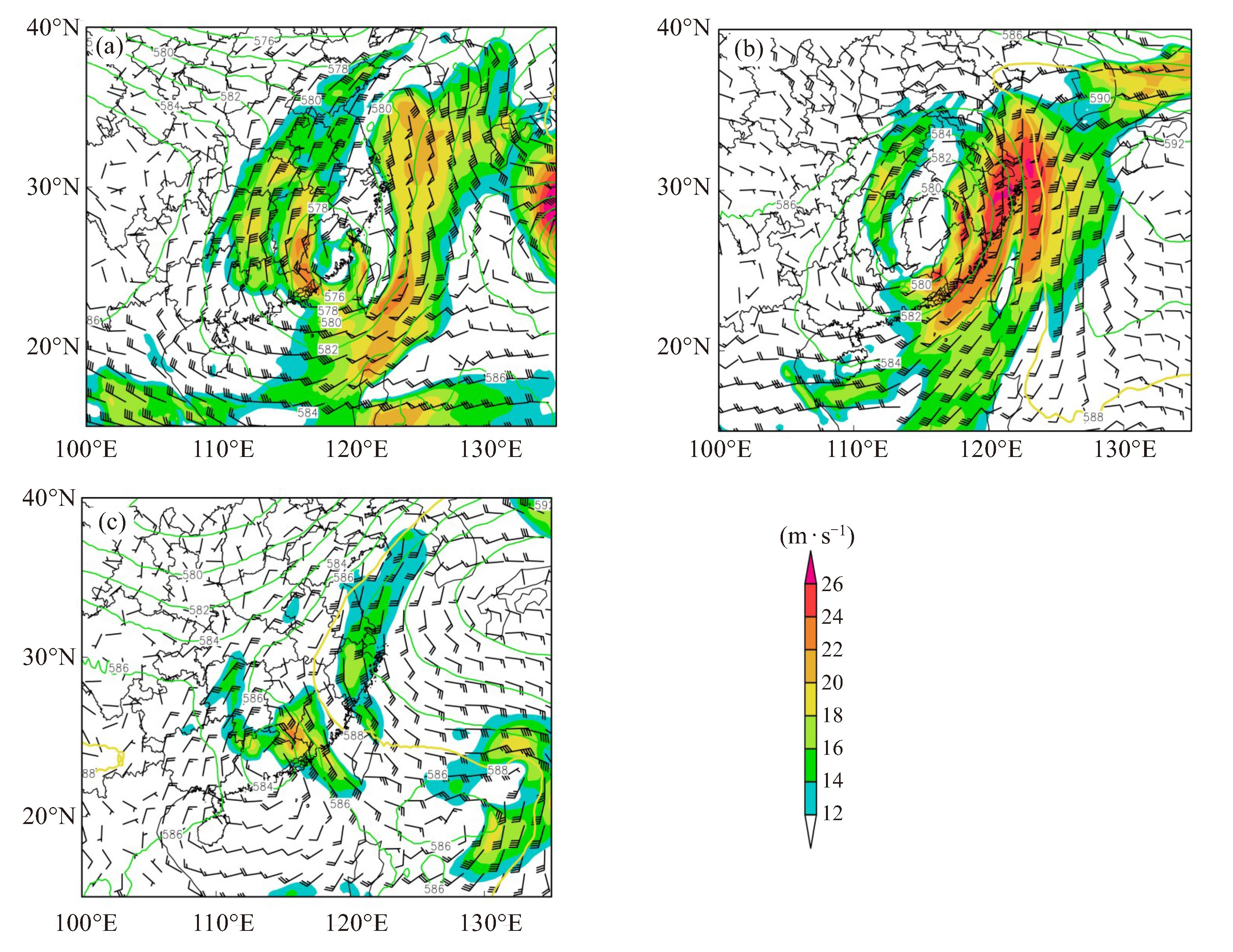
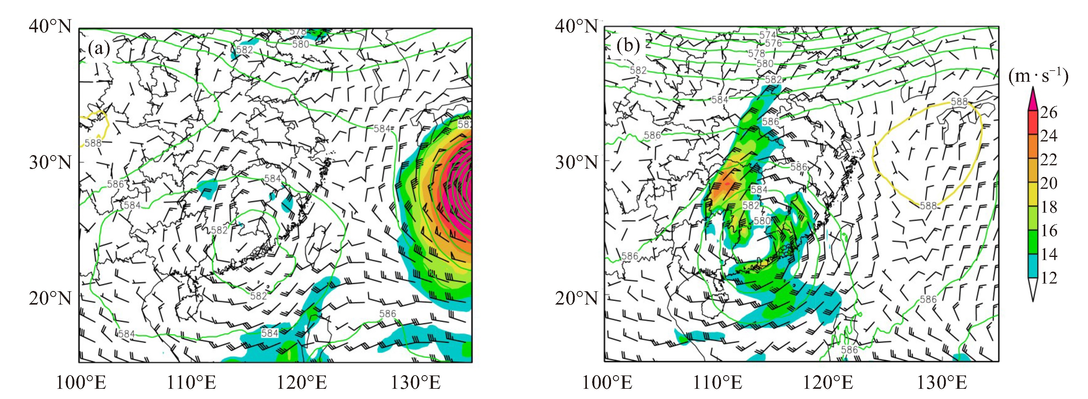
图 5 9012号(a)、0604号(b)和1006号(c)台风登陆后一天500 hPa高度场(等值线,单位:dagpm)和850 hPa风场(填色部分风速≥12 m·s-1)
-
[1] 张东, 林芳妮, 何如意, 等. 珠江口以西登陆热带气旋引发粤东暴雨的成因和预报着眼点分析[J]. 热带气象学报, 2019, 35(1): 14-24. [2] 卜松, 李英. 华东登陆热带气旋降水不同分布的对比分析[J]. 大气科学, 2020, 44(1): 27-38. [3] 汪铃儿, 陈科艺. 2000—2020年西太平洋热带气旋路径对江淮梅雨期降水的影响研究[J]. 热带气象学报, 2023, 39(4): 632-642. [4] 滕代高, 罗哲贤, 代刊, 等. 登陆热带风暴Bilis(2006)暴雨特征及其可能原因[J]. 南京气象学院学报, 2008, 31(3): 369-380. [5] 罗玲, 娄小芬, 胡亮, 等. 0604号强热带风暴"碧利斯"结构特征及其暴雨成因分析[J]. 气象科学, 2013, 33(2): 208-214. [6] 陈联寿, 孟智勇, 丛春华. 台风暴雨落区研究综述[J]. 海洋气象学报, 2017, 37(4): 1-7. [7] 唐一宁, 冶磊, 李煜斌, 等. 台风"山竹"降水非对称特征及其与环境流场的相互作用研究[J]. 热带气象学报, 2023, 39(5): 774-784. [8] 贺晓露, 李格, 谭江红. 台风"暹芭"引发鄂北暴雨不同阶段中尺度特征及成因分析[J]. 气象科技, 2024, 52(5): 668-680. [9] 潘佳文, 杨奇志, 魏鸣, 等. 台风"苏迪罗"螺旋雨带造成福州特大暴雨成因分析[J]. 热带气象学报, 2018, 34(6): 774-782. [10] 任丽, 王晓雪, 张桂华. 近60年黑龙江省台风暴雨统计及环流特征分析[J]. 热带气象学报, 2023, 39(2): 159-170. [11] 林巧美, 陈裕强, 卢尉, 等. 基于精细化观测的揭阳市台风降水分布及环流特征分析[J]. 气象与环境科学, 2024, 47(6): 46-53. [12] 朱星球, 李婕, 尹小飞, 等. 基于EOF的江西台风暴雨分布环境场分析[J]. 热带气象学报, 2024, 40(5): 714-724. [13] 董鹤松, 隋妍, 尹路婷, 等. 2020年延边地区两次相似路径台风暴雨特征及成因分析[J]. 气象灾害防御, 2024, 31(4): 18-24. [14] 马怡轩, 于翡, 徐国强. 台风"暹芭"残余环流引发中国东部暴雨的影响原因及数值模拟研究[J]. 热带气象学报, 2024, 40(5): 834-844. [15] 高晓梅, 白莉娜, 郭蓉, 等. 台风"利奇马"北上锋生导致山东省创纪录暴雨天气学成因分析[J]. 热带气象学报, 2023, 39(2): 145-158. [16] 黄哲, 韩路杰, 金茹, 等. 浙江天目山区台风暴雨特征和成因分析[J]. 气象科技, 2022, 50(6): 812-821. [17] 林小红, 杨舒楠, 王健治, 等. 过台湾岛的台风所引发的东南沿海地区的暴雨特征分析[J]. 气象, 2023, 49(9): 1 097-1 107. [18] 覃武, 赵金彪, 黄荣成, 等. 台风"山竹"登陆结构变化及造成广西强降水异常分布的成因分析[J]. 热带气象学报, 2019, 35(5): 587-595. [19] 姚才, 贺海晏, 黄明策. 华南西部登陆台风的大尺度条件对比分析[J]. 中山大学学报(自然科学版), 2005, 44(6): 110-113, 122. [20] 程正泉, 陈联寿, 李英. 登陆台风降水的大尺度环流诊断分析[J]. 气象学报, 2009, 67(5): 840-850. [21] 杨逸霖, 钱燕珍, 葛旭阳, 等. 台风"黑格比"登陆期间浙江地区水汽演变特征分析[J]. 热带气象学报, 2023, 39(3): 413-423. [22] 岳彩军, 曹钰. "海棠"台风(2005)降水非对称分布特征成因之大气因子研究[J]. 热带气象学报, 2014, 30(2): 219-228. [23] 黄燕燕, 蒙伟光, 冯业荣, 等. 华南登陆台风降水不对称性及持续性问题[J]. 气象, 2023, 49(4): 385-399. [24] 林小红, 刘爱鸣, 刘通易, 等. 2013年"苏力"与"潭美"相似路径台风大暴雨落区差异分析[J]. 热带气象学报, 2015, 31(4): 517-525. [25] 高留喜, 刘畅, 丛春华, 等. 两个相似路径台风造成山东降水明显差异的成因分析[J]. 海洋气象学报, 2020, 40(4): 60-68. [26] 余贞寿, 陈敏, 叶子祥, 等. 相似路径热带气旋"海棠"(0505)和"碧利斯"(0604)暴雨对比分析[J]. 热带气象学报, 2009, 25(1): 37-47. [27] 涂小萍, 徐蓉, 姚日升, 等. 登陆福建台风外围环流中宁波地区强对流天气分析[J]. 热带气象学报, 2019, 35(2): 154-165. [28] 林小红, 任福民, 刘爱鸣, 等. 近46年影响福建的台风降水的气候特征分析[J]. 热带气象学报, 2008, 24(4): 411-416. [29] 刘燕, 林良勋. 登陆福建的热带气旋对广东降水的影响[J]. 广东气象, 2007, 29(2): 14-17. [30] 梁洁华, 陈浩, 陈晓旸, 等. 登陆福建台风对粤东降水的影响[J]. 广东气象, 2020, 42(5): 10-14. -

 下载:
下载:
 点击查看大图
图(9)
计量
- 文章访问数: 9
- HTML全文浏览量: 6
- PDF下载量: 0
- 被引次数: 0
 粤公网安备 4401069904700003号