


Analysis of the 19 September 2023 EF3 Tornado in Funing, Jiangsu, and Multi-Band Radar Monitoring and Early Warning Techniques Ⅰ: Weather Analysis and Multi-Band Radar Observation
-
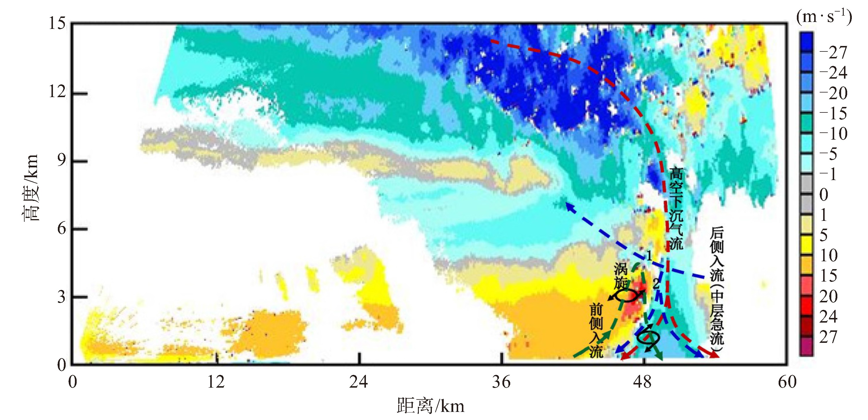
摘要: 为深入认识江苏龙卷形成的机理,提高龙卷监测预警业务精准性。本文以江苏历史上9月份罕见的2023年9月19日阜宁EF3级龙卷(简称“9.19”阜宁龙卷)个例为切入点,从实况与灾情、天气背景和环境条件、多波段雷达协同观测及效果3方面展开讨论。(1)“9.19”阜宁龙卷是梅雨天气背景下发生的强龙卷事件。200 hPa天气形势图出现气流分支和13.3 μm通道红外云图有楔状云,是“9.19”阜宁龙卷深对流强迫和提前研判的重要指标。(2) 热力和动力条件急剧变化表明大气的极不稳定和强劲的垂直上升运动,是触发强龙卷的重要潜势指标。CAPE跃增为2 288.7 J · kg-1,CIN骤减至0.2 J · kg-1,LCL骤降为1 005.0 hPa(69 m),K指数骤升为40.2 ℃;0~1 km风切变跃增为10.9 m ·s-1,0~3 km风切变跃增为19.2 m ·s-1,0~6 km风切变跃增为21.9 m ·s-1。(3) 苏北多波段天气雷达网可提供最低探测高度100~350 m为主的超低空资料,为龙卷监测预警提供了有力条件。“9.19”阜宁龙卷过程中苏北多波段天气雷达自适应观测效果较好,非人工干预下宝应XD(X-band Dualpolarization Weather Radar)雷达能合理地进行RHI(Range Height Indicater)自适应扫描,较完整地观测到龙卷超级单体的演变过程和垂直流场特征。尤其中低层反射率因子核(RC)和穹隆结构、中高层高悬回波、3~5 km高度后侧“V”型缺口和穹隆的悬挂回波和中高层高悬回波之间的东北-西南走向的弱回波带演变特征,以及前侧入流的涡管环流场、高空下沉气流和后侧入流(急流)分流的流场特征。研究结果为江苏多波段天气雷达监测预警龙卷以及龙卷物理过程的客观认识提供了参考依据。
-
关键词:
- “9.19”阜宁龙卷 /
- EF3级 /
- 天气分析 /
- 多波段雷达 /
- 监测预警
Abstract: In order to deepen the objective understanding of the formation mechanisms of tornadoes in Jiangsu and improve the accuracy of tornado monitoring and early warning, this paper investigates the rare EF3-level tornado case that occurred on 19 September 2023 in Funing, Jiangsu, an unprecedented event for September in the history of Jiangsu. The analysis focuses on the reality and disaster situation, weather background and environmental conditions, and multi-band radar collaborative observations. The results are as follows. (1) The"9.19"Funing EF3-Level tornado was a strong tornadic event that occurred under the background of Meiyu weather. The air flow branching in the 200 hPa weather pattern and the wedgeshaped cloud in the 13.3 μm infrared satellite imagery were important indicators of deep convective forcing and advanced prediction of"9.19"Funing tornado. (2) Sudden changes of thermal and dynamic conditions signaled an extremely unstable atmosphere with strong vertical ascent, serving as important potential indicators for the triggering of a strong tornado. At 20:00 BJT on September 19 at the Sheyang sounding station, the Convective Available Potential Energy (CAPE) increased to 2 288.7 J · kg-1, Convective Inhibition (CIN) decreased to 0.2 J·kg-1, the Lifting Condensation Level (LCL) plummeted to 1 005.0 hPa (69 m), and K index increased to 40.2 ℃. Vertical wind shear rose to 10.9 m · s-1 (0-1 km), 19.2 m · s-1 (0-3 km), and 21.9 m· s-1 (0-6 km). (3) The multi-band weather radar network in northern Jiangsu can provide ultra-low altitude data, with the lowest detection height ranging from 100 m to 350 m, which greatly meets the internal needs of tornado monitoring and early warning. The multi-band weather radar in northern Jiangsu had a good adaptive scanning capabilities on the"9.19"Funing tornado. Without manual intervention, Baoying XD radar can carry out reasonable Range Height Indicator (RHI) adaptive scanning, completely capturing the evolution and vertical flow field of tornadic supercell. The Scans clearly revealed key structural featares: a low-to-mid-level reflectivity factor core (RC) and dome structure; middle-to-high-level overhanging echoes; a "V"-shaped gap at 3-5 km height; and a northeast-to-southwest oriented weak echo band between overhanging echoes of the dome and the middle-to-high-level overhanging echoes. The flow field was characterized by the vortex tube circulation in the forward-flank inflow, high-altitude subsidence flow, and the divided rear-flank inflow jet. These results provide a valuable reference for the multi-band weather radar monitoring and warning of tornadoes using multi-band weather radar in Jiangsu and contribute to the objective understanding of tornadic physical processes. -

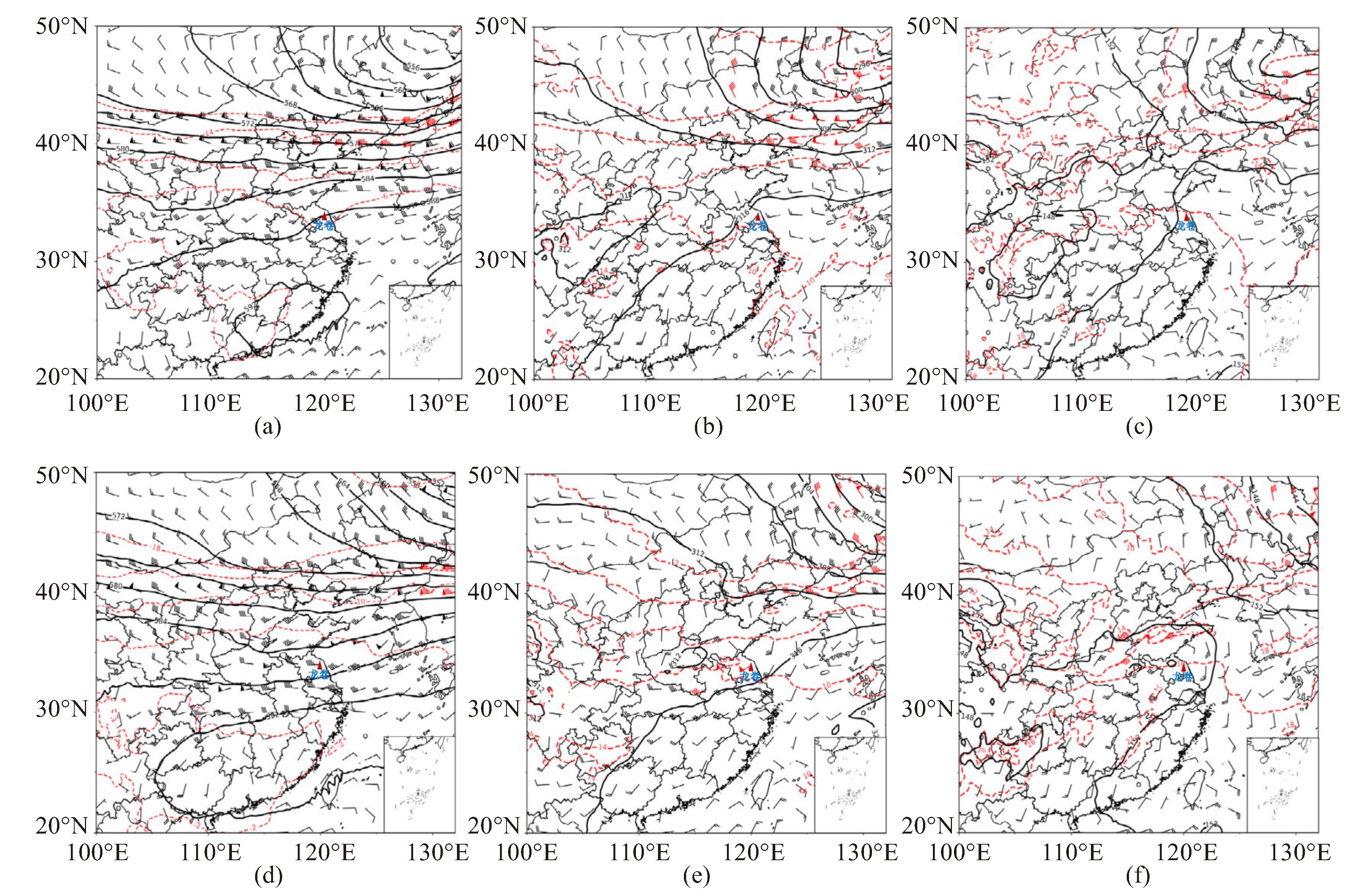
图 2 2023年9月19日08时(a、b、c)和20时(d、e、f)500 hPa(a、d)、750 hPa(b、e)、850 hPa(c、f)天气形势图
黑色实线为等位线,红色虚线为等温线,风矢代表风速风向。

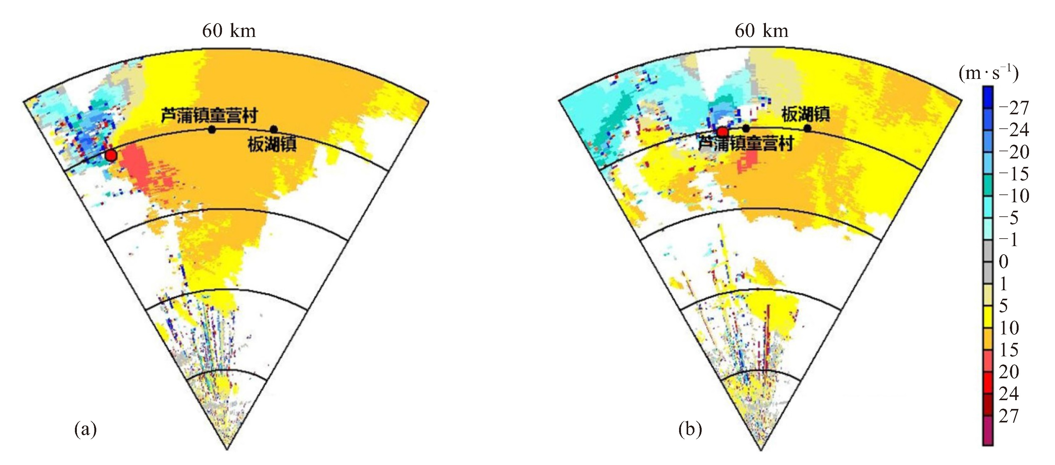
图 7 2023年9月19日19:57(a)、20:15(b)宝应XD雷径向速度图和TVS特征快速识别结果
TVS位置由红色圆点标注,TVS告警时刻为20:02和20:20,“9.19”阜宁龙卷发生地芦蒲镇童营村和板湖镇由黑色圆点标注。
表 1 龙卷发生前射阳站(临近阜宁)的环境参数
环境参数 9月19日08时 9月19日20时 对流有效位能/(J·kg-1) 1 088.9 2 288.7 对流抑制有效位能/(J·kg-1) 115.0 0.2 抬升凝结高度/hPa 984.0 1 005.0 K指数/℃ 35.4 40.2 0~1 km风切变/(m·s-1) 0.7 10.9 0~3 km风切变/(m·s-1) 5.1 19.2 0~6 km风切变/(m·s-1) 10.2 21.9  下载: 导出CSV
-
[1] 张晶晶, 黄先香, 蔡康龙, 等. 2023年中国龙卷活动及灾情特征[J]. 气象科技进展, 2024, 14(1): 15-24. [2] 郑永光, 朱文剑, 姚聃, 等. 风速等级标准与2016年6月23日阜宁龙卷强度估计[J]. 气象, 2016, 11(42): 1 289-1 303. [3] 张小玲, 杨波, 朱文剑, 等. 2016年6月23日江苏阜宁EF4级龙卷天气分析[J]. 气象, 2016, 11(42): 1 304-1 314. [4] 周海光. "6.23"江苏阜宁EF4级龙卷超级单体风暴中尺度结构研究[J]. 地球物理学报, 2018, 9(61): 3 617-3 639. [5] 张玉洁, 苑文华, 徐百言. 江苏阜宁龙卷超级单体风暴的雷达资料分析[J]. 干旱气象, 2018, 37(3): 409-418. [6] 钱维宏, 艾阳, 陈笑晨. 辽宁开原龙卷强对流过程的扰动天气环境[J]. 地球物理学报, 2021, 64(5): 1 531-1 541. [7] 阎琦, 张爱忠, 沈历都, 等. 2019年辽宁开原龙卷风观测事实分析[J]. 灾害学, 2021, 36(1): 112-116. [8] 贾旭轩, 李得勤, 冯呈呈, 等. 辽宁开原强龙卷的卫星云图和雷达回波演变特征分析[J]. 气象与环境学报, 2022, 38(3): 11-18. [9] 范雯杰, 俞小鼎. 中国龙卷的时空分布特征[J]. 气象, 2015, 41(7): 793-805. [10] 俞小鼎, 赵娟, 范雯杰. 中国龙卷的时空分布与关键环境参数特征[J]. 热带气象学报, 2021, 37 (5/6): 681-692. [11] 冯佳玮, 闵锦忠, 庄潇然. 中国龙卷时空分布及其环境物理量特征[J]. 热带气象学报, 2017, 33(4): 530-539. [12] 郑永光. 中国龙卷气候特征和环境条件研究进展综述[J]. 气象科技进展, 2020, 10(6): 69-75. [13] 郑永光, 田付友, 周康辉, 等. 雷暴大风与龙卷的预报预警和灾害现场调查[J]. 气象科技进展, 2018, 8(2): 55-61. [14] 王啸华, 黄荣, 李杨, 等. 江苏一次梅雨期疑似龙卷现场调查报告[J]. 气象科学, 2020, 40(4): 546-553. [15] 张涛, 关良, 郑永光, 等. 2019年7月3日辽宁开原龙卷灾害现场调查及所揭示的龙卷演变过程[J]. 气象, 2020, 46(5): 603-617. [16] 蔡康龙, 俞小鼎, 李彩玲, 等. 2019年广西临桂微下击暴流和广东湛江龙卷现场灾情调查对比分析[J]. 气象, 2021, 47(2): 230-241. [17] 蔡康龙, 黄先香, 戴春容, 等. 2020年8月9日黑龙江绥化龙卷灾情调查与天气雷达识别[J]. 热带气象学报, 2021, 37(5/6): 792-800. [18] 朱君鉴, 蔡康龙, 龚佃利, 等. 登陆台风"摩羯"(1814)在山东引发龙卷的灾害调查与天气雷达识别[J]. 海洋气象学报, 2019, 39(4): 21-34. [19] 李彩玲, 杨波, 姚聃, 等. 2021年5月14日武汉龙卷现场调查及雷达探测特征分析[J]. 暴雨灾害, 2022, 41(2): 142-150. [20] 徐芬, 郑媛媛, 孙康远, 等. 江苏龙卷时空分布及风暴形态特征[J]. 气象, 2021, 47(5): 517-528. [21] 周晓敏, 郑永光. 2020年梅雨期江苏两次龙卷过程环境背景和龙卷母体风暴形态特征分析[J]. 气象科技进展, 2020, 10(6): 34-42. [22] 张楠, 杨晓君, 林晓萌, 等. 线状对流中EF3级强龙卷的多尺度机理研究[J]. 气象, 2020, 46(7): 873 -884. [23] 王炳赟, 魏鸣, 范广洲, 等. 1522强台风"彩虹"螺旋雨带中衍生龙卷的超级单体演变与机理研究Ⅰ: 谱宽和速度[J]. 热带气象学报, 2018, 34(4): 472-480. [24] 王炳赟, 魏鸣, 范广洲, 等. 1522强台风"彩虹"螺旋雨带中衍生龙卷的超级单体演变与机理研究Ⅱ: 回波结构和钩状回波形成机理[J]. 热带气象学报, 2018, 34(4): 481-488. [25] 郑永光, 蓝渝, 曹艳察, 等. 2019年7月3日辽宁开原EF4级强龙卷形成条件、演变特征和机理[J]. 气象, 2020, 46(5): 589-602. [26] 袁潮, 王式功, 马湘宜, 等. 2019年7月3日辽宁开原龙卷形成环境背景及机理探究[J]. 高原气象, 2021, 40(2): 384-393. [27] 王琛, 魏鸣. 苏北2020年6月12日高邮龙卷的形成机理和回波演变分析[J]. 热带气象学报, 2021, 37(5/6): 812-823. [28] 王秀明, 俞小鼎. 热带一次致灾龙卷形成物理过程研究[J]. 气象学报, 2019, 77(3): 387-404. [29] 戴建华, 王国荣, 龚剑, 等. 梅雨锋中尺度涡旋内微型超级单体龙卷的形成研究[J]. 热带气象学报, 2021, 37(5/6): 693-709. [30] 高守亭, 左群杰, 杨帅. 龙卷生成动力学初探[J]. 气象科技进展, 2018, 8(2): 24-35. [31] 唐晓文, 李峰, 刘高平. 龙卷形成过程及母体风暴结构与演变研究进展[J]. 成都信息工程大学学报, 2018, 33(6): 599-605. [32] 郑媛媛, 朱红芳, 方翔, 等. 强龙卷超级单体风暴特征分析与预警研究[J]. 高原气象, 2009, 28(3): 617-625. [33] 王啸华, 郑媛媛, 濮梅娟, 等. 强天气综合报警追踪平台功能设计及龙卷预警中的应用[J]. 气象科技进展, 2018, 8(3): 61-69. [34] 姚聃. 龙卷预报预警体系建设—气象现代化的前沿挑战[J]. 气象科技进展, 2020, 10(6): 19-22. [35] 刁秀广, 孟宪贵, 张立, 等. 台风"摩羯"与"温比亚"环流中龙卷小尺度涡旋特征及可预警性分析[J]. 海洋气象学报, 2019, 39(3): 19-28. [36] 张一平, 梁俊平, 牛淑贞, 等. 豫东龙卷的环境条件和雷达监测预警分析[J]. 高原气象, 2020, 39 (5): 1 089-1 101. [37] 俞小鼎. 强对流天气的多普勒天气雷达探测和预警[J]. 气象科技进展, 2011, 1(3): 31-41. [38] 郑永光, 刘菲凡, 张恒进. 中国龙卷研究进展[J]. 气象, 2021, 47(11): 1 319-1 335. [39] 肖艳姣, 王珏, 王志斌, 等. 双偏振天气雷达精细化探测技术对2021年两个龙卷风暴识别能力的影响分析[J]. 暴雨灾害, 2022, 41(2): 130-141. [40] 刘俊, 周红根, 刘新安, 等. 江苏北部龙卷雷达组网探测策略[J]. 气象科技, 2021, 49(2): 157-165. [41] 张培昌, 杜秉玉, 戴铁丕. 雷达气象学(第二版)[M]. 北京: 气象出版社, 2001: 388-390. [42] 吴彬. 灾害性对流天气的双偏振多普勒雷达监测与机理研究[D]. 南京: 南京信息工程大学, 2023. [43] 黄先香, 俞小鼎, 炎利军, 等. 1804号台风"哎云尼"龙卷分析[J]. 气象学报, 2019, 77(4): 645-661. [44] DAVIES J R. Streamwise vorticity: The origin of updraft rotation in supercell storms[J]. Atmos Sci, 1984, 41(20): 2 991-3 006. [45] ROTUNNO R, KLEMP J. On the rotation and propagation of simulated supercell thunderstorms[J]. Atmos Sci, 1985, 42(42): 271-292. [46] 郑媛媛, 张备, 王晡华, 等. 台风龙卷的环境背景和雷达回波结构分析[J]. 气象, 2015, 41(8): 942-952. [47] 吴芳芳, 俞小鼎, 张志刚, 等. 对流风暴内中气旋特征与强对流天气[J]. 气象, 2012, 38(11): 1 330-1 338. [48] GRAVEN J P, BROOKS H E. Baselin climatology of sounding derieved parameters associated with deep moist convection[J]. Natl Wea Dig, 2004, 28: 13-24. [49] MARKOWSKI P M, RICHARDSON Y. Mesescale Meteorology in Midlatitudes[M]. New York: Wiley-Blackwell, 2010. -


 点击查看大图

图(9) / 表(1)
计量
- 文章访问数: 17
- HTML全文浏览量: 8
- PDF下载量: 2
- 被引次数: 0
 粤公网安备 4401069904700003号