



Vertical Structure Analysis of Wind Field of a Typhoon Rainstorm Based on Wind Profile Radar
-
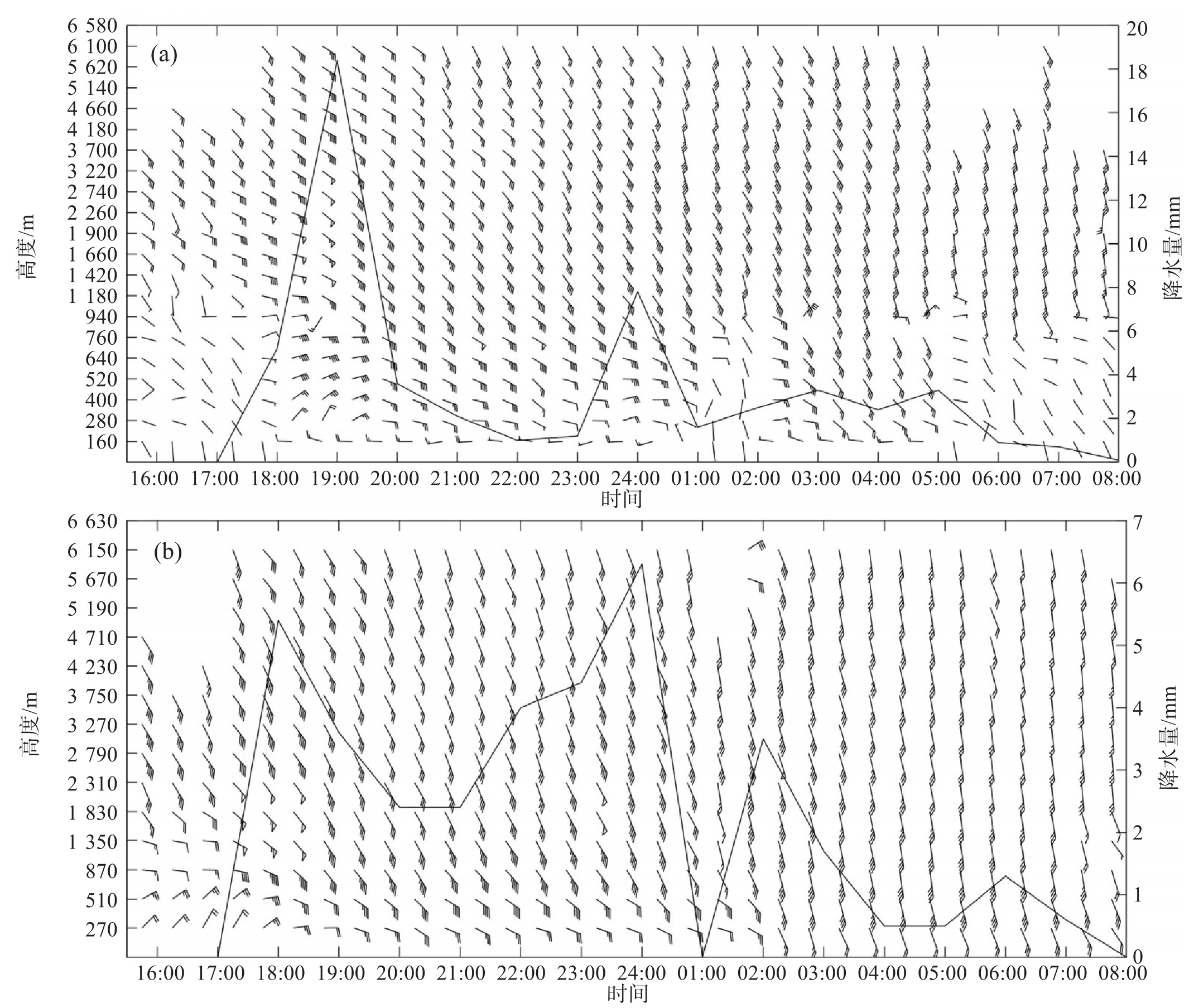
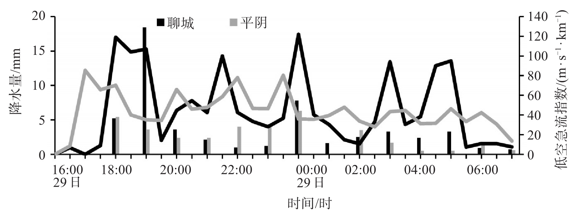
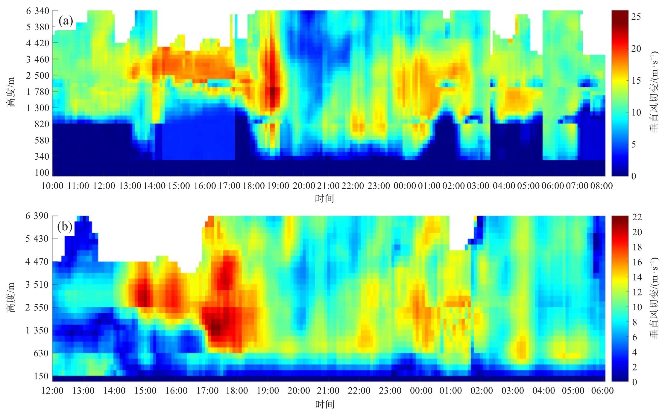
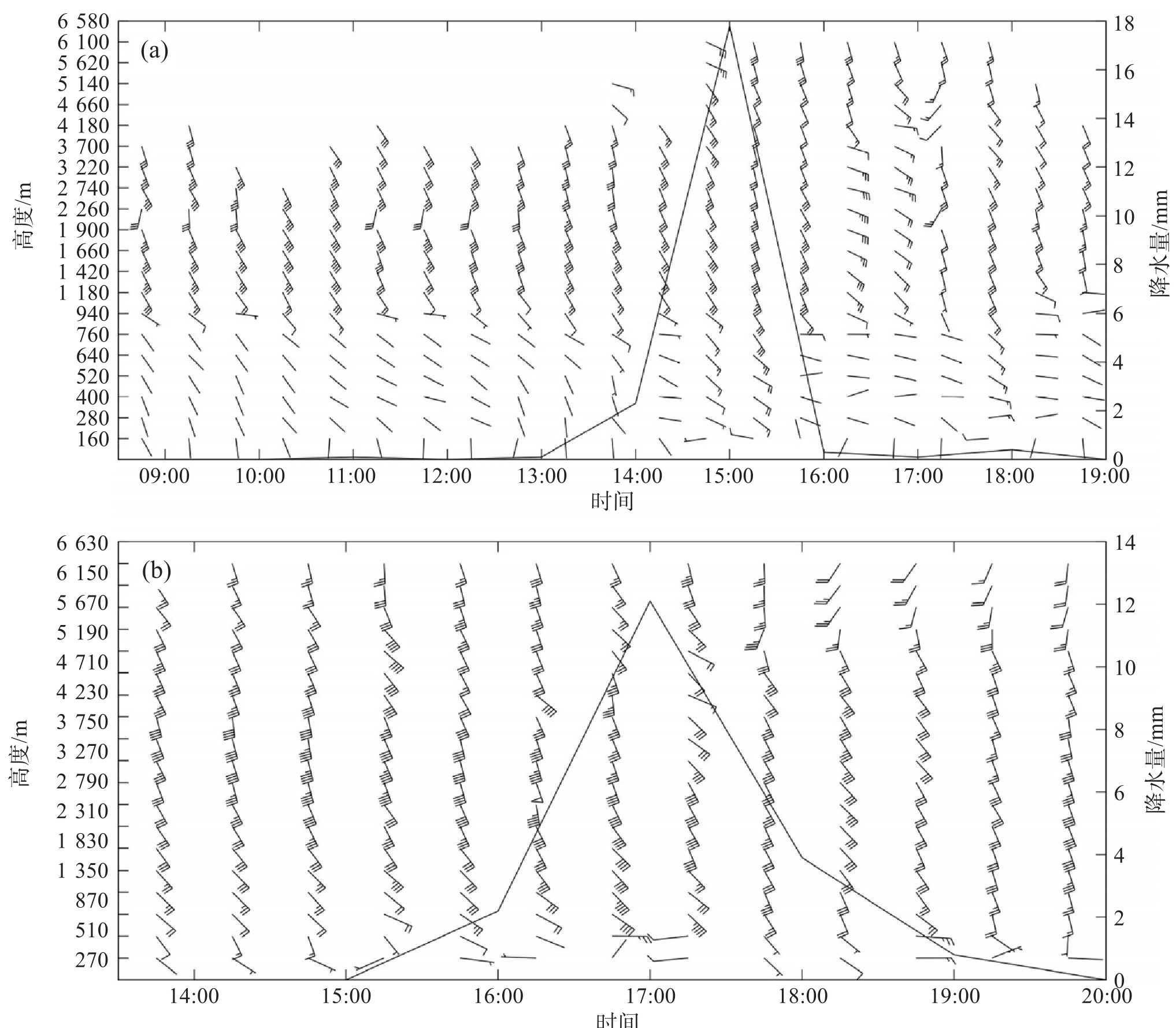
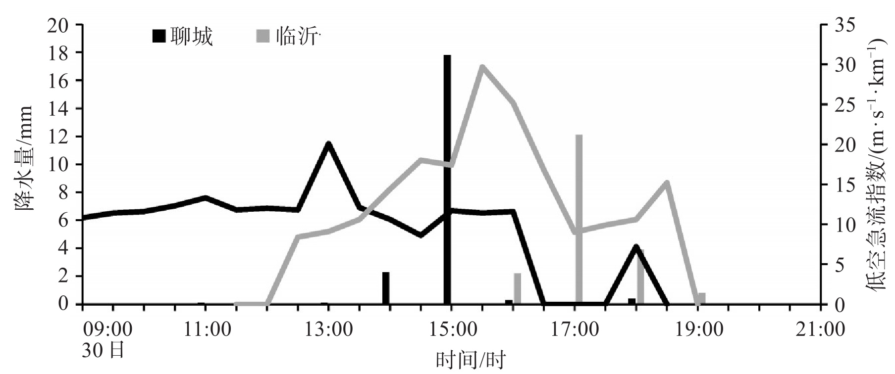
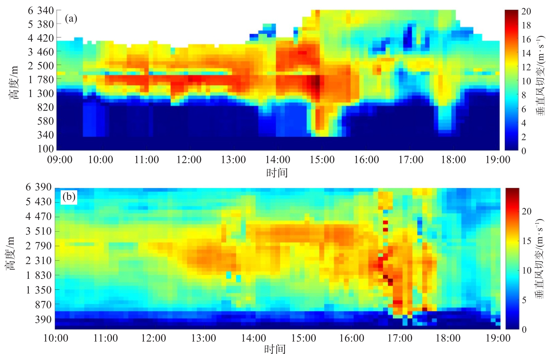
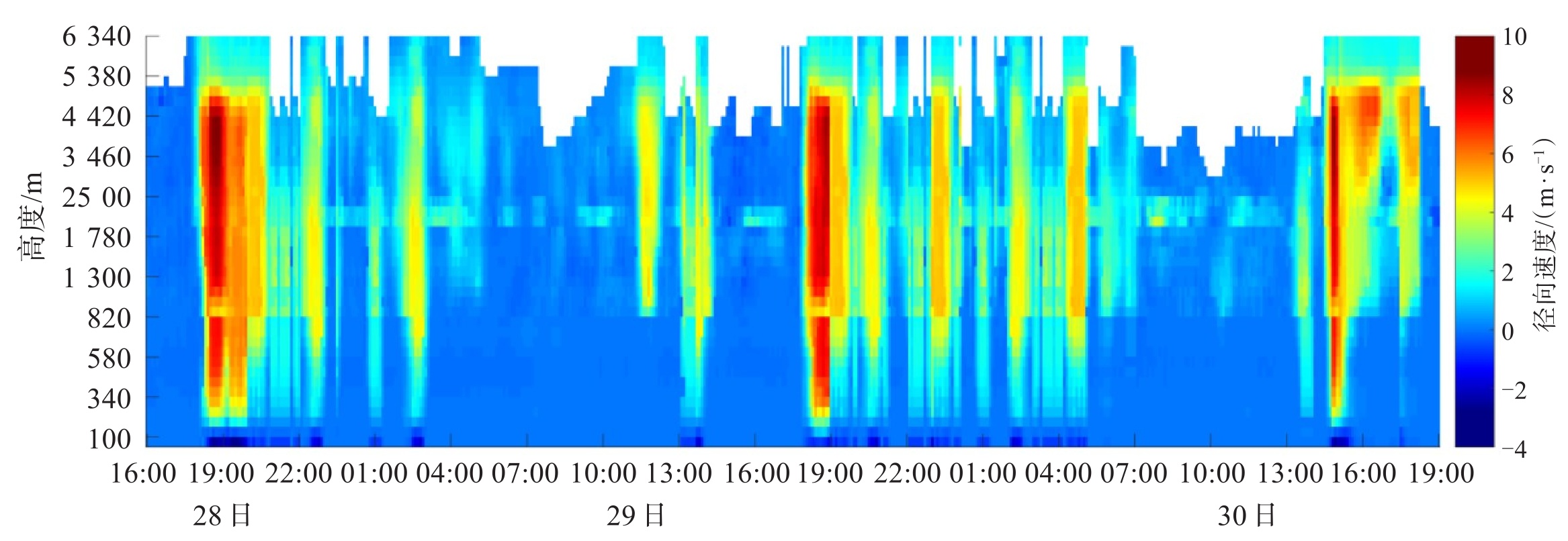
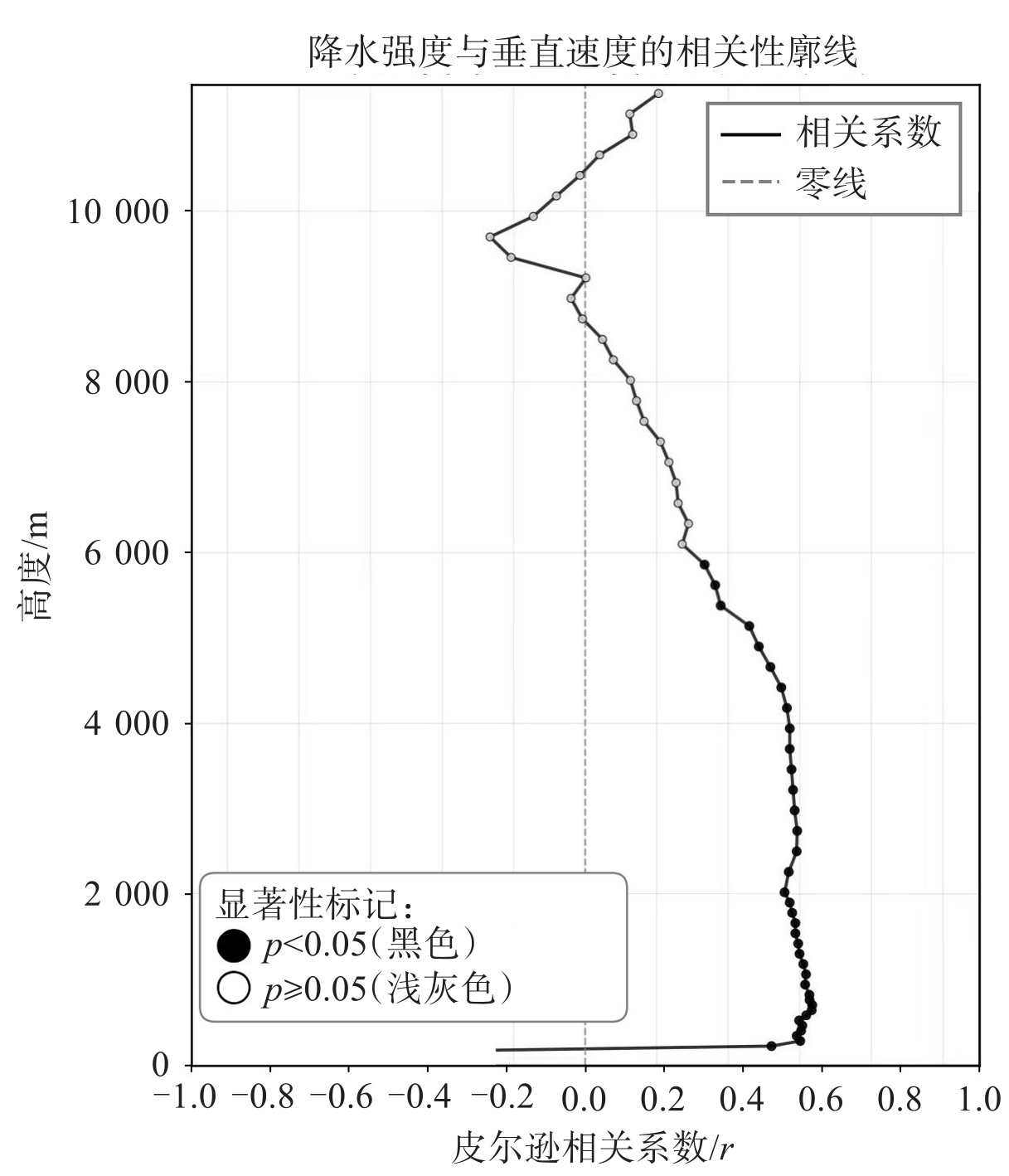
摘要: 利用常规气象观测资料、自动站小时和分钟加密资料、四部风廓线雷达资料、中国气象局热带气旋最佳路径数据集以及NCAR(National Center for Atmospheric Research)再分析资料,对2023年7月28—30日台风“杜苏芮”造成山东强降水过程进行分析。结果表明,(1)台风“杜苏芮”造成山东强降水过程大致分三个阶段,主导影响系统先后是台风倒槽、台风残余低压环流以及东南风急流。(2)台风倒槽阶段:具有对流性降水特征,中层东北风增强增厚、低层东北风转东南风的过程伴随强降水的发生;低空急流指数的增大对降水的指示存在滞后性;垂直风切变的突增对应降水的开始,减弱对应降水结束。(3)台风残余低压环流阶段:以稳定性降水为主,中高层东南风增强、低层东北风也增强并转为东南风的过程对应强降水的发生,而整层东南风结构对应弱降水;低空急流指数增大较雨强增大的提前时间在1 h左右,该指数的振荡对应持续性弱降水的发生;强降水发生前,中层垂直风切变首先增大,较强降水开始提早3~4 h,中层强切变中心向高层和低层伸展对应强降水的发生。(4)东南风急流阶段:低层东南风显著增强对应强降水发生;低空急流指数增大较雨强增大提前约2 h;该阶段中层垂直风切变维持在较高水平(10 m·s-1以上),并在强降水前进一步显著增大,时间较强降水开始提早5~6 h。(5)风廓线雷达垂直速度与降水出现的时间较为对应,且速度大小与降水强度存在一定的正相关。Abstract: Based on conventional meteorological observation data, automatic weather station hourly and minute high-resolution data, data from four wind profiler radars, the CMA best-track dataset, and NCAR (National Center for Atmospheric Research) reanalysis data, this study investigates the heavy precipitation process caused by Typhoon Doksuri in Shandong Province from July 28 to 30, 2023. The results indicate that: (1) The heavy precipitation event caused by Typhoon Doksuri in Shandong can be roughly divided into three stages, dominated sequentially by the typhoon inverted trough, the typhoon residual low-pressure circulation, and the southeasterly low-level jet. (2) Typhoon inverted trough stage: Characterized by convective precipitation, the onset of heavy rainfall is closely linked to the strengthening and thickening of mid-level northeasterly winds, accompanied by the transition of low-level winds from northeasterly to southeasterly. The increase in the low-level jet index exhibits a delayed response in indicating precipitation. The sudden increase in vertical wind shear corresponds to the initiation of precipitation, while its decrease signals the end. (3) Typhoon residual low-pressure circulation stage: Dominated by stratiform precipitation, the occurrence of heavy rainfall aligns with the strengthening of mid-to-upper-level southeasterlies and the intensification of low-level northeasterlies turning into southeasterlies. A uniform southeasterly profile throughout the column corresponds to continuous light rain. The surge in the low-level jet index precedes the intensification of rainfall by approximately 1 hour, and the oscillation of this index relates to sustained light precipitation. Prior to heavy rainfall, the mid-level vertical wind shear increases first, leading the strong precipitation by 3 to 4 hours. The expansion of the strong mid-level shear center toward both upper and lower levels acts as an indicator for heavy precipitation. (4) Southeasterly jet stage: A significant enhancement of low-level southeasterly winds corresponds to heavy rainfall. The increase in the low-level jet index precedes the peak rainfall intensity by about 2 hours. During this stage, the mid-level vertical wind shear remains consistently high at around 10 m·s-1. Before heavy precipitation occurs, the mid-level vertical wind shear further increases, leading the intense rainfall by 5 to 6 hours. (5) The vertical velocity measured by the wind profiler radars closely matches the timing of precipitation, exhibiting a positive correlation between velocity magnitude and precipitation intensity.
-
Key words:
- typhoon /
- rainstorm /
- low-level jet /
- wind profiler radar
-

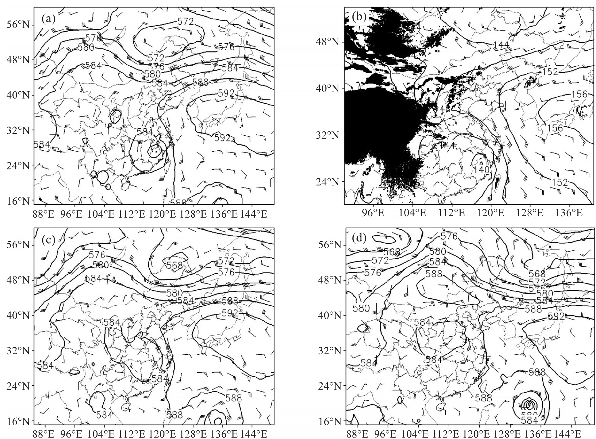
图 2 2023年7月28日20时500 hPa(a)、850 hPa(b)、29日08时500 hPa(c)和30日08时500 hPa(d)高空综合图
黑色实线为等高线。
-
[1] 高留喜, 杨晓霞, 刘畅, 等. 台风"摩羯"(1814)的路径特点与预报分析[J]. 海洋气象学报, 2019, 39(4): 108-115. [2] 陈联寿, 丁一汇. 西太平洋台风概论[M]. 北京: 科学出版社, 1979. [3] 姚秀萍, 黄逸飞, 包晓红, 等. "23·7"华北极端强降水特征和水汽条件研究[J]. 气象学报, 2024, 82(5): 585-599. [4] 朱莉, 王治国, 李华宏, 等. 西行台风背景下云南一次短时强降水过程的成因分析[J]. 热带气象学报, 2020, 36(6): 744-758. [5] 何平. 相控阵风廓线雷达[M]. 北京: 气象出版社, 2006. [6] 董保举, 刘劲松, 高月忠. 基于风廓线雷达资料的暴雨天气过程分析[J]. 气象科技, 2009, 37(4): 411-414. [7] 严嘉明, 赵兵科, 张帅, 等. 边界层风廓线雷达对登陆台风观测适用性评估[J]. 应用气象学报, 2021, 32(3): 332-346. [8] 郭运, 汤胜茗, 王旭, 等. 不同台风降水强度下风廓线雷达适用性研究[J]. 热带气象学报, 2021, 37(2): 268-276. [9] 王文波, 李晓利, 曹云飞, 等. 风廓线雷达资料在一次对流暴雨过程中的特征分析[J]. 干旱气象, 2025, 43(4): 627-636. [10] 于雷, 丁和悦, 张会, 等. 河北保定市"23·7"强降水过程的观测特征分析[J]. 气候与环境研究, 2024, 29(4): 478-496. [11] 高晓梅, 白莉娜, 郭蓉, 等. 台风"利奇马"北上锋生导致山东省创纪录暴雨天气学成因分析[J]. 热带气象学报, 2023, 39(2): 145-158. [12] 王彦, 刘一玮, 孙晓磊. 利用风廓线雷达资料分析一次强降水过程的风垂直切变特征[J]. 暴雨灾害, 2017, 36(2): 171-176. [13] 颜海帆, 戴竹君, 姜有山, 等. 基于新型观测资料分析台风"烟花"短时强降水成因[J]. 气象科学, 2024, 44(5): 857-869. [14] 刘淑媛, 郑永光, 陶祖钰. 利用风廓线雷达资料分析低空急流的脉动与暴雨关系[J]. 热带气象学报, 2003, 19(3): 285-290. [15] 李青春, 程丛兰, 全继萍, 等. 夏季两次不同强度暴雨过程的低空急流特征及其作用对比分析[J]. 气象, 2022, 48(11): 1384-1401. [16] 张庆池, 吕翔, 刘子贺, 等. 登陆台风不同强度降水的雨滴谱特征对比[J]. 气象, 2022, 48(12): 1617-1628. [17] 陈锦鹏, 冯业荣, 蒙伟光, 等. 基于卷积神经网络的逐时降水预报订正方法研究[J]. 气象, 2021, 47(1): 60-70. [18] 阎丽凤, 杨成芳. 山东省灾害性天气预报技术手册[M]. 北京: 气象出版社, 2014. -

 下载:
下载:
 点击查看大图
图(13)
计量
- 文章访问数: 193
- HTML全文浏览量: 3
- PDF下载量: 20
- 被引次数: 0
 粤公网安备 4401069904700003号