



Numerical Simulation Analysis on Orographic Rainfall Enhancement in Eastern Zhejiang Mountains During Typhoon Lekima
-
摘要: 近年来多个台风造成浙江东部山区出现极端强降水,给预报带来巨大挑战。为研究山区降水增幅机制,以2019年9号台风“利奇马”为例,利用WRF(V4.1)模式对其进行数值模拟,从水汽、动力、热力和云微物理四个方面分析了浙东山区降水增幅成因。结果表明“利奇马”登陆前6 h,以括苍山为代表的浙东山区降水增幅明显,山区迎风坡垂直上升速度大,低层辐合叠加高空辐散,并对应着位涡高值区,地形摩擦辐合及抬升作用为山区强降水的产生和中尺度对流系统的触发提供了有利的动力条件。山区上空假相当位温梯度较大,水汽辐合较强,且山区低层存在显著的对流不稳定,同样有利于强降水发生。丰富的水汽和强上升运动使山区霰粒子和雪粒子含量更多,并伴随更高效的霰粒子向雨水以及雪粒子向雨水转化,从而造成山区降水较平原增幅明显。细致的云微物理转化分析表明,此次台风降水主要为:低层丰富的水汽上升凝结为云水,少部分云水碰并转化为雨水,大部分云水随着上升气流到0 ℃层以上转化为雪和霰,生成的雪大部分融化为雨水,小部分被碰并转化为霰,后通过霰融化成雨水,最后降至地面形成降水。上述云微物理转化过程,在山区更加显著。“利奇马”造成浙东山区降水增幅是水汽、动力、热力和云微物理过程共同作用的结果。Abstract: In recent years, a number of typhoons have triggered extreme heavy rainfall in the eastern mountainous region of Zhejiang Province, posing considerable challenges to operational forecasting. To investigate the mechanisms of orographic rainfall enhancement, numerical simulations of Typhoon Lekima (the 9th typhoon in 2019) were conducted using the Weather Research and Forecasting (WRF) model (V4.1). From the perspectives of water vapor, dynamics, thermodynamics and cloud-microphysics, this study investigates the causes of rainfall enhancement over the Kuocang Mountains. The results indicate that significant precipitation enhancement occurred over the windward slopes of the Kuocang Mountains six hours before Typhoon Lekima made landfall. The strong vertical updrafts were induced at the windward slopes due to strong low-level convergence superimposed by upper-level divergence, coinciding with a high potential vorticity zone. Orographic frictional convergence and forced lifting provided favorable dynamic conditions for the occurrence of heavy rainfall and the initiation of mesoscale convective systems. Thermodynamically, a steep horizontal gradient of pseudo-equivalent potential temperature gradient and strong low-level moisture convergence produced a highly unstable environment which is favorable for typhoon vortex development and heavy rainfall. Microphysically, abundant moisture and vigorous updrafts resulted in an elevated concentrations of graupel and snow particles over the mountains, along with more efficient conversion from graupel to rainwater and snow to rainwater which further amplifies precipitation in the mountains relative to the adjacent plains. Detailed analysis reveals that the dominant cloud microphysical processes involved in typhoon precipitation by condensation of abundant low-level water vapor into cloud water. While a small portion of cloud water was accreted directly into rainwater, the majority was transported above the 0 ℃ isotherm layer by updrafts, then converted into snow and graupel. The most of generated snow was subsequently melted into rainwater, with a small portion being accreted into graupel, which was ultimately melted into rainwater before reaching the surface, and finally fell to the ground as precipitation. These cloud microphysical processes were notably more active over the mountainous terrain. In conclusion, the rainfall enhancement in the eastern Zhejiang mountains during the Typhoon Lekima was the result of the combined effects of moisture supply, dynamic forcing, thermodynamic instabilities, and cloud microphysical processes.
-

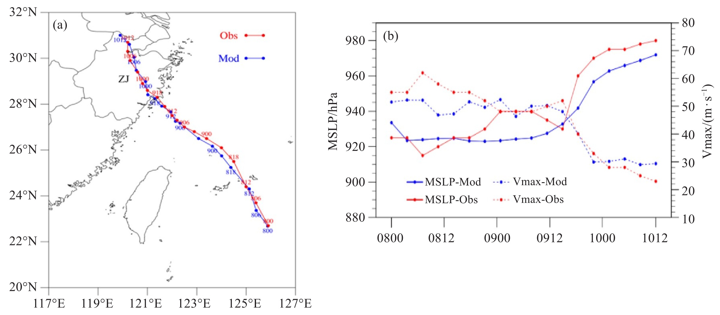
图 1 2019年8月8日00时—10日12时台风“利奇马”实况(红色Obs)和D03-3km模拟(蓝色Mod)路径(a);实况(红色)和模拟(蓝色)的海平面最低气压(MSLP,单位:hPa)和近地面最大风速(Vmax,单位:m∙s-1)(b)
实线表示MSLP,虚线表示Vmax。

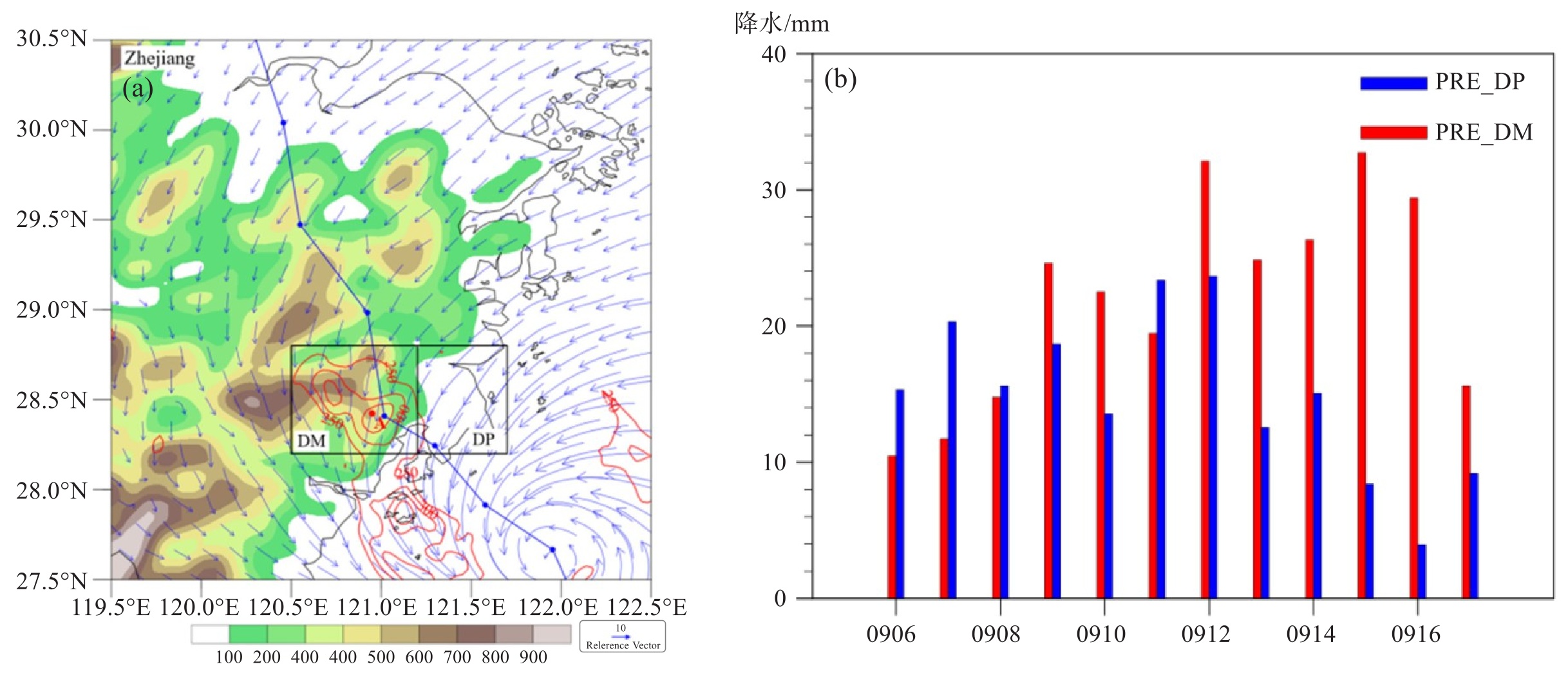
图 3 登陆前12 h累积降水(等值线,红色点A为降水大值中心之一)和9日12时10 m风场(单位:m∙s-1)及海拔高度(填色,单位:m)(a);山区和平原平均小时降水强度(纵坐标,单位:mm)(b)
a中DM方框表示山区,对应经纬度为120.5~121.2 °E,28.2~28.8 °N,DP表示平原,对应经纬度为121.2~121.7 °E,28.2~28.8 °N。b中PRE_DM表示山区,PRE_DP表示平原。

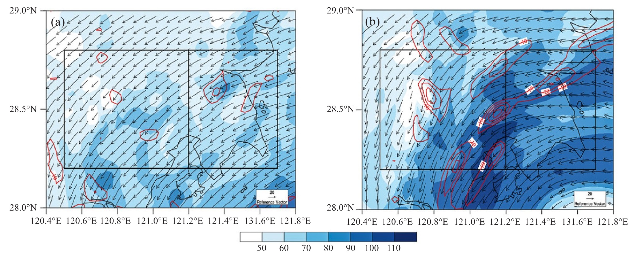
图 4 9日08时(a)、9日15时(b)2 km高度上水汽输送通量(填色,单位:g∙kg-1 ∙m∙s-1)、水汽通量散度(红色等值线,单位:10-7 g∙hPa-1 ∙cm-2 ∙s-1)和水平风场(箭头,单位:m∙s-1)分布图

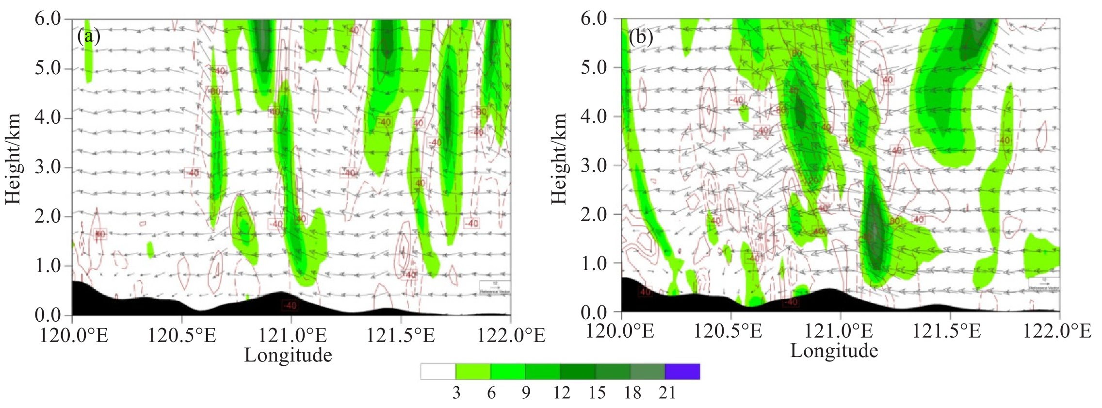
图 5 9日08时(a)、9日15时(b)过降水大值中心(120.95 °E,28.4 °N,图 3a红色点A)沿45 °(东北—西南方向)的位涡(填色,单位:PVU)、散度(等值线,单位:10-5 s-1)和合成风(矢量箭头,水平风和垂直风×10,单位:m∙s-1)垂直剖面

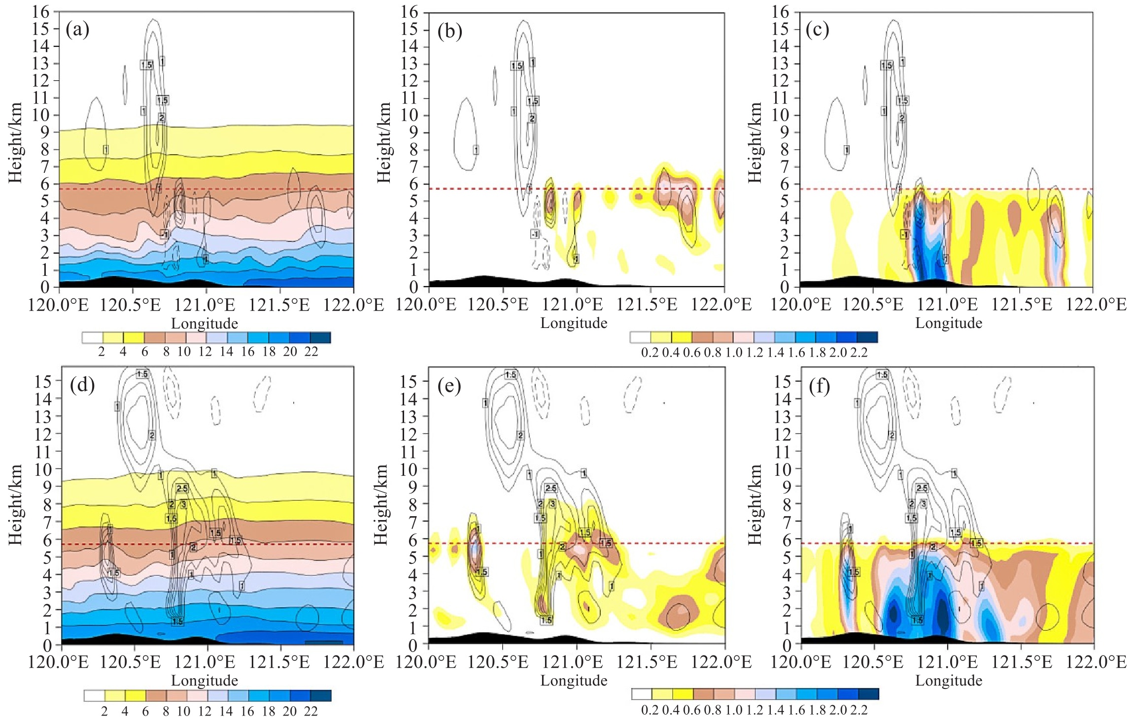
图 7 过降水大值中心A的比湿(单位:g∙kg-1) (a、d)、云水混合比(单位:g∙kg-1)(b、e)和雨水混合比(单位:g∙kg-1)(c、f)纬向垂直剖面
黑色等直线表示垂直速度,实线为上升运动(单位:m∙s-1),红色虚线为0 ℃层高度。a~c. 9日08时;d~f. 9日15时。

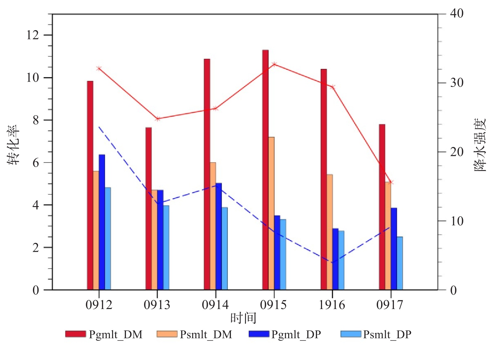
图 11 9日12—17时逐小时山区和平原的平均小时降水强度(折线;红色:山区;蓝色:平原;右侧纵坐标,单位:mm)及整层平均霰(雪)融化为雨水的转化率(单位:10-3 g·kg-1·s-1)
Pgmlt_DM:山区霰粒子向雨水转化率;Psmlt_DM:山区雪粒子向雨水转化率;Pgmlt_DP:平原霰粒子向雨水转化率;Psmlt_DP:平原雪粒子向雨水转化率。
附表 WSM6方案云微物理转化过程
缩写 描述 缩写 描述 Pgaci 霰碰并云冰造成霰增长 Prevp 雨水和水汽之间转化(蒸发/凝华) Pgacw 霰碰并云水造成霰增长 Psdep 水汽凝华为雪 Pgacr 霰碰并雨水造成霰增长 Pgdep 霰和水汽之间转化 Pgacs 霰碰并雪造成霰增长 Praut 云水自动转化为雨水 Psaci 雪碰并云冰造成雪增长 Psaut 云冰自动转化为雪 Psacw 雪碰并云水造成雪增长 Pgaut 雪自动转化为霰 Pracs 雨水碰并雪造成霰增长 Pgevp 霰融化时的蒸发作用 Psacr 雪碰并雨水造成雪或霰增长 Psevp 雪融化时的蒸发作用 Praci 云冰碰并雨水造成雪或霰增长 Pcond 水汽凝结成云水 Piacr 云冰粘附雨水生成雪或霰 Pgfrz 雨水冻结 Pracw 雨水碰并云水造成雨水增长 Pimlt 云冰瞬时融化 Pgmlt 霰融化为雨水 Pihmf 云水均匀冻结为云冰 Psmlt 雪融化为雨水 Pihtf 云水不均匀冻结为云冰 Pgeml 增大的霰融化率导致雨水增加 Pidep 水汽和云冰之间的转化 Pseml 增大的雪融化率导致雨水增加 pigen 水汽异质核化为云冰  下载: 导出CSV
-
[1] 雷小途, 陈联寿. 热带气旋与中纬度环流系统相互作用的研究进展[J]. 热带气象学报, 2001, 17(4): 452-461. [2] Atallah E, Bosart L F, Aiyyer A R. Precipitation distribution associated with landfalling tropical cyclones over the eastern United States[J]. Monthly Weather Review, 2007, 135(6): 2185-2206. [3] Chen L S, Li Y, Cheng Z Q. An overview of research and forecasting on rainfall associated with landfalling tropical cyclones[J]. Advances in Atmospheric Sciences, 2010, 27(5): 967-976. [4] 王黎娟, 任晨平, 崔晓鹏, 等. "碧利斯"暴雨增幅高分辨率数值模拟及诊断分析[J]. 大气科学学报, 2013, 36(2): 147-157. [5] 陈忠明, 黄福均, 何光碧. 热带气旋与西南低涡相互作用的个例研究Ⅰ. 诊断分析[J]. 大气科学, 2002, 26(3): 352-360. [6] 李江南, 蒙伟光, 闫敬华, 等. 热带风暴Fitow(0114)暴雨的中尺度特征及成因分析[J]. 热带气象学报, 2005, 21(1): 24-32. [7] Chen S S, Knaff J A, Marks F D Jr. Effects of vertical wind shear and storm motion on tropical cyclone rainfall asymmetries deduced from TRMM[J]. Monthly Weather Review, 2006, 134(11): 3190-3208. [8] Jiang H Y, Halverson J B, Zipser E J. Influence of environmental moisture on TRMM-derived tropical cyclone precipitation over land and ocean[J]. Geophysical Research Letters, 2008, 35(17): L17806. [9] 余贞寿, 冀春晓, 董美莹, 等. 浙江时间多尺度台风暴雨增幅特征的统计研究[J]. 气象, 2017, 43(12): 1496-1506. [10] 沈杭锋, 高天赤, 周春雨, 等. 台风海葵引发浙西山区大暴雨的成因[J]. 气象, 2014(6): 733-743. [11] 潘劲松, 滕代高, 张福青, 等. 超强台风Soudelor(2015)登陆前后局地强降水的动力过程分析[J]. 中国科学(地球科学), 2018, 48(4): 487-509. [12] 钱卓蕾, 钱月平, 马洁华. 台风"烟花"登陆浙江前后强降水雨带变化特征及成因分析[J]. 气象科学, 2024, 44(4): 643-654. [13] Franklin C N, Holland G J, May P T. Sensitivity of tropical cyclone rainbands to ice-phase microphysics[J]. Monthly Weather Review, 2005, 133(8): 2473-2493. [14] 程锐, 宇如聪, 傅云飞, 等. 台风"云娜"在近海强度变化及结构特征的数值研究Ⅰ: 云微物理参数化对云结构及降水特征的影响[J]. 气象学报, 2009, 67(5): 764-776. [15] 杨文霞, 冉令坤, 洪延超. 台风Wipha云微物理特征数值模拟[J]. 科技导报, 2010, 28(23): 34-39. [16] Yang M J, Braun S A, Chen D S. Water budget of typhoon nari (2001)[J]. Monthly Weather Review, 2011, 139(12): 3809-3828. [17] Ren C P, Cui X P. The cloud-microphysical cause of torrential rainfall amplification associated with Bilis (0604)[J]. Science China Earth Sciences, 2014, 57(9): 2100-2111. [18] McCumber M, Tao W K, Simpson J, et al. Comparison of ice-phase microphysical parameterization schemes using numerical simulations of tropical convection[J]. Journal of Applied Meteorology and Climatology, 1991, 30(7): 985-1004. [19] Cheng R, Yu R C, Fu Y F, et al. Impact of cloud microphysical processes on the simulation of Typhoon Rananim near shore. Part Ⅰ: Cloud structure and precipitation features[J]. Acta Meteorologica Sinica, 2011, 25(4): 441-455. [20] Tao W K, Shi J J, Lin P L, et al. High-resolution numerical simulation of the extreme rainfall associated with typhoon morakot. Part Ⅰ: comparing the impact of microphysics and PBL parameterizations with observations[J]. Terrestrial, Atmospheric and Oceanic Sciences, 2011, 22(6): 673. [21] 袁金南, 黄燕燕, 刘春霞, 等. 陆地摩擦对登陆热带气旋路径和强度影响的模拟研究[J]. 热带气象学报, 2007, 23(6): 531-537. [22] 陈涛, 董林, 罗玲, 等. 台风利奇马登陆期间的对流结构特征及对强降雨影响[J]. 气象, 2021, 47(12): 1433-1443. [23] Shi D L, Chen G H. Double warm-core structure and potential vorticity diagnosis during the rapid intensification of Supertyphoon Lekima (2019)[J]. Journal of the Atmospheric Sciences, 2021: 2471-2492. [24] 许广, 费建芳, 黄小刚, 等. 一次飑线过程的云微物理参数化方案数值试验及其成因分析[J]. 气象科学, 2017, 37(3): 283-292. [25] Dudhia J. Numerical study of convection observed during the winter monsoon experiment using a mesoscale two-dimensional model[J]. Journal of the Atmospheric Sciences, 1989, 46(20): 3077-3107. [26] Hong S Y, Juang H H, Zhao Q Y. Implementation of prognostic cloud scheme for a regional spectral model[J]. Monthly Weather Review, 1998, 126(10): 2621-2639. [27] 花丛, 刘奇俊. 登陆台风"罗莎"中云物理特征的数值模拟研究[J]. 热带气象学报, 2011, 27(5): 626-638. [28] 庞琦烨, 平凡, 沈新勇, 等. 不同微物理方案对台风"彩虹"(2015)降水影响的比较研究[J]. 大气科学, 2019, 43(1): 202-220. -

 点击查看大图
计量
- 文章访问数: 2
- HTML全文浏览量: 0
- PDF下载量: 0
- 被引次数: 0
 粤公网安备 4401069904700003号