



Bias Analysis of the CMA-GD Model Prediction for Localized Heavy Rainfall over Hainan Island During Spring Easterly Flow
-
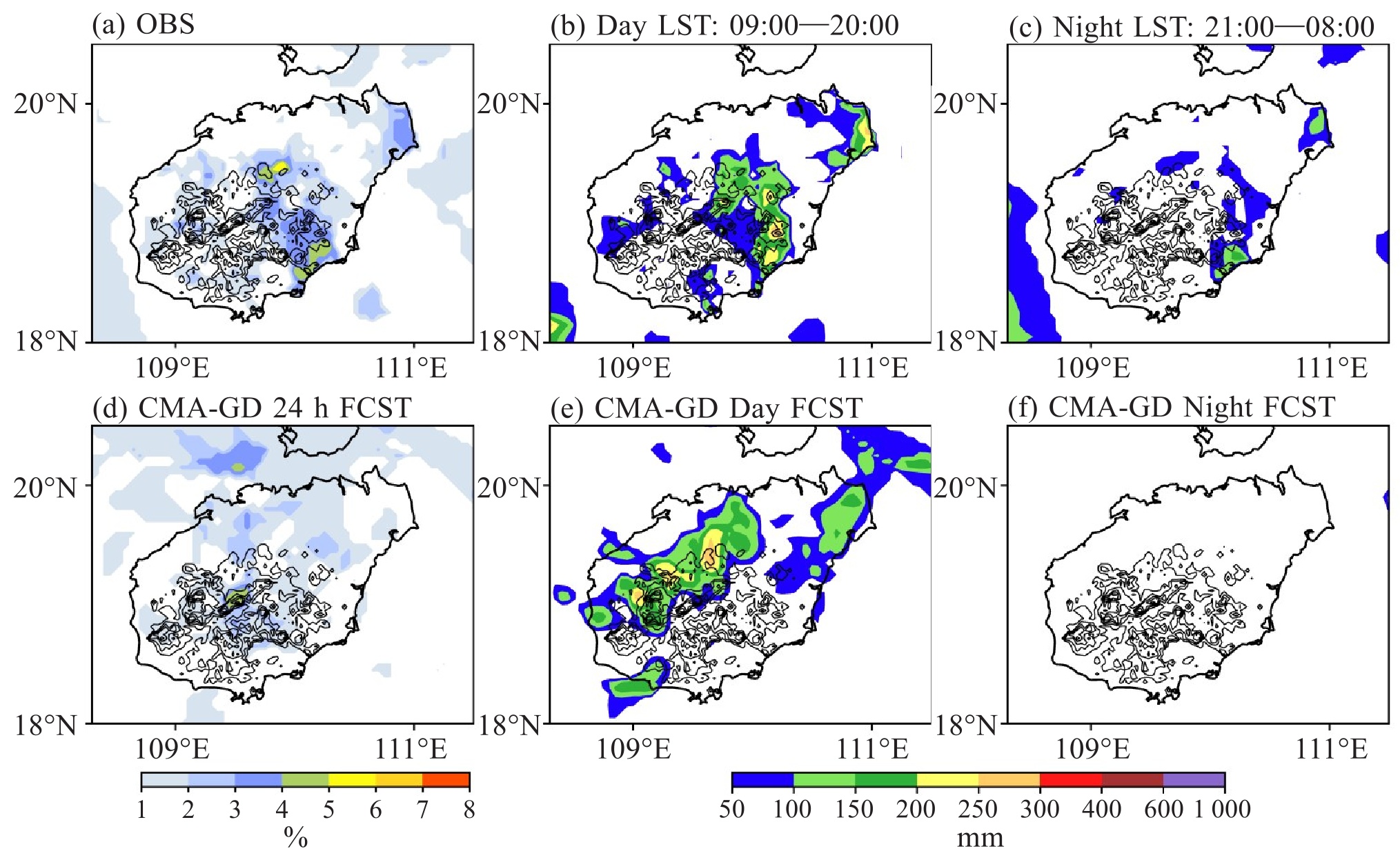
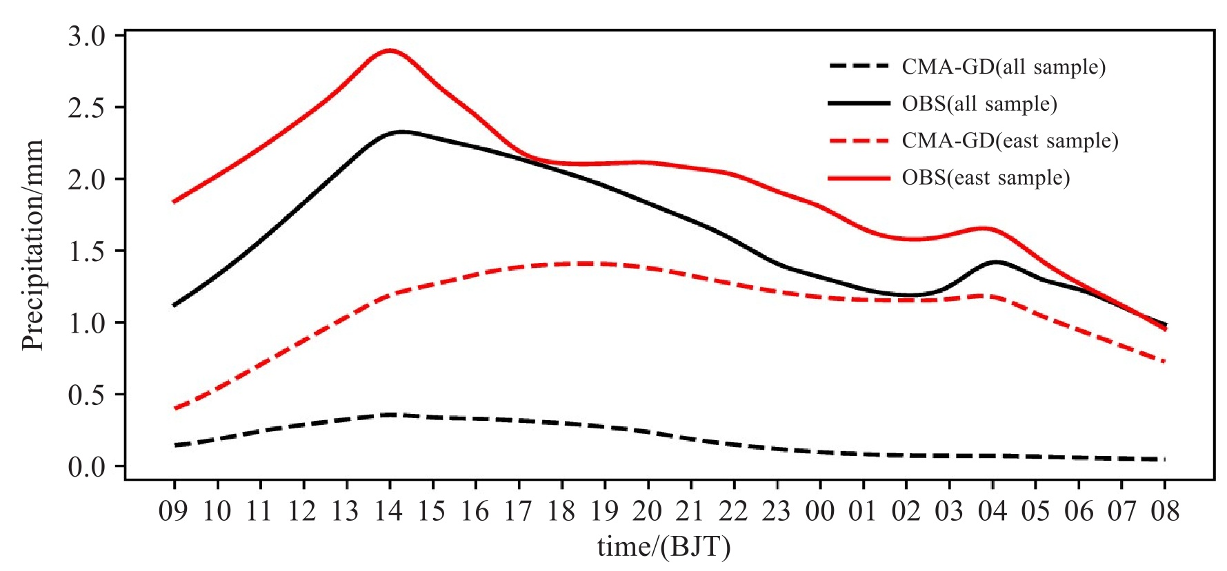
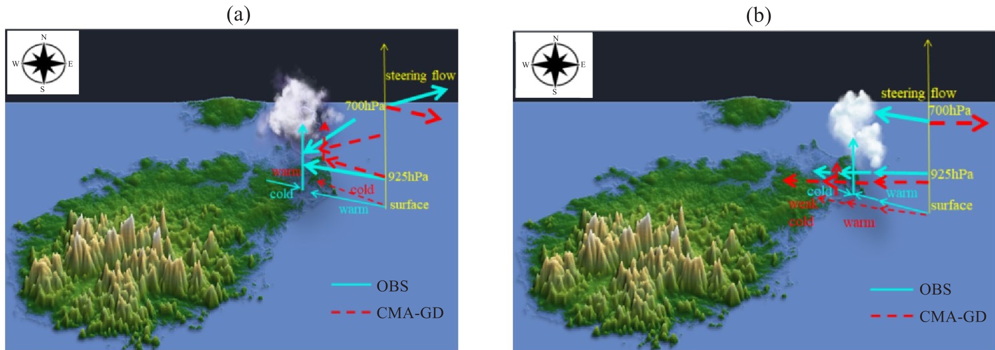
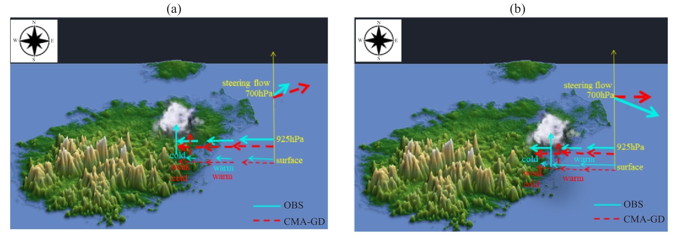
摘要: 海南岛春季在偏东气流影响下易在其东部丘陵和平原地区形成局地暴雨中心,但当前对流尺度模式预报存在较大偏差。利用海南岛加密自动站实况降水、1 km分辨率中国气象局陆面数据同化系统CLDAS(CMA Land Data Assimilation System)和欧洲中期天气预报中心的第五代再分析资料(ERA5)评估华南中尺度模式(CMA-GD,3 km)对海南岛2021—2023年春季在低层偏东气流背景下东部丘陵和平原地区局地暴雨的预报偏差,结果表明:模式对午后中西部山区的暴雨有一定预报能力,但容易漏报东部丘陵平原地区白天和凌晨的暴雨,对平均降水日变化的双峰特征体现不足;偏东气流的关键影响天气系统是出海冷高压,模式对出海冷高压的强度和位置等预报存在偏差,进而导致对低层(850 hPa以下)风场的预报出现系统性偏差:风向存在明显右偏(角度最大偏差约30 °),925 hPa以下的风速比实况偏大2~3 m·s-1;同时,1 000 hPa的比湿和相对湿度分别比实况偏小约2 g·kg-1和12%。通过对比东部丘陵和平原地区昼夜典型暴雨成因,发现模式容易低估暴雨的原因主要包括:(1)低层风向右偏的偏差导致对辐合气流的锋生强度低估;(2)低层干偏差导致低层大气抬升凝结高度LCL和自由对流高度LFC偏高;(3)对近地层地表摩擦导致的风速减幅预报偏弱,导致辐合强度偏弱,不利对流的触发;(4)不能很好反映垂直于丘陵地形的低层风速水平方向和垂直方向的变化特征;(5)对地表温度的预报偏差导致与降水有关的局地海陆风环流预报不准确。Abstract: During spring, Hainan Island is prone to localized heavy rainfall over its eastern hilly and plain regions driven by low-level easterly airflow. However, significant forecast biases persist in operational convective-scale numerical models. This study evaluates the performance of the CMA-GD mesoscale model (3 km resolution) in simulating these localized heavy rainfall events during 2021−2023 utilizing high-density automatic weather station observations, 1-km resolution CLDAS (CMA Land Data Assimilation System) land surface datasets, and ERA5 reanalysis data. The results indicate that while the model adequately simulate afternoon heavy rainfall over the central-western mountains, it consistently underestimates daytime and early morning heavy rainfall occurring during the in the east. Consequently, the model fails to capture the observed bimodal d diurnal cycle of mean precipitation. Synoptically, these errors are linked to the misrepresentation of the offshore cold high-pressure system. The model exhibits a systematic clockwise bias (approximately 30 °) in the low-level (below 850 hPa) wind direction and overestimates wind speeds below 925 hPa by 2-3 m·s-1 compared to observations. Concurrently, it underestimates specific humidity (approximately 2 g·kg-1) and relative humidity (~12%, ) respectively, at 1 000 hPa and Diagnostic analysis of typical cases reveals five primary mechanisms for underestimation of heavy rainfall: (1) The clockwise wind direction bias weakens frontogenesis within convergent flows; (2)The low-level dry bias elevates the Lifting Condensation Level (LCL) and Level of Free Convection (LFC); (3) Insufficient surface friction reduces forecast convergence, inhibiting convective initiation; (4)Inadequate representation of the horizontal and vertical wind shear perpendicular to the terrain; and (5)Forecast biases in land surface temperature disrupt local sea-land breeze circulations, altering precipitation patterns.
-
Key words:
- spring low-level easterly winds /
- Hainan Island /
- heavy rainfall /
- CMA-GD /
- forecast bias
-

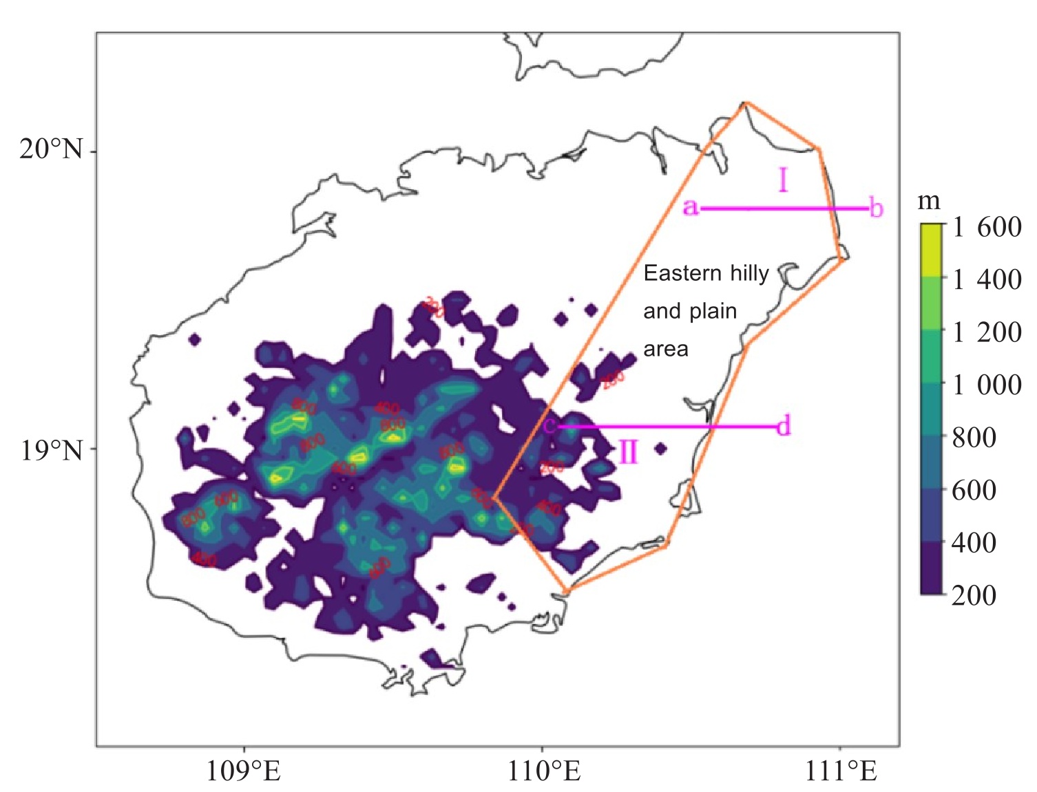
图 3 2021—2023年3—5月偏东风背景下所有暴雨样本的实况(黑色实线)、CMA-GD(黑色虚线)逐时平均降水对比(区间为108.8~110.9 °E,18~20 °N)和东部丘陵平原地区暴雨样本的实况(红色实线)、CMA-GD(红色虚线)逐时平均降水对比(区间为110.1~110.9 °E,18.7~20 °N)

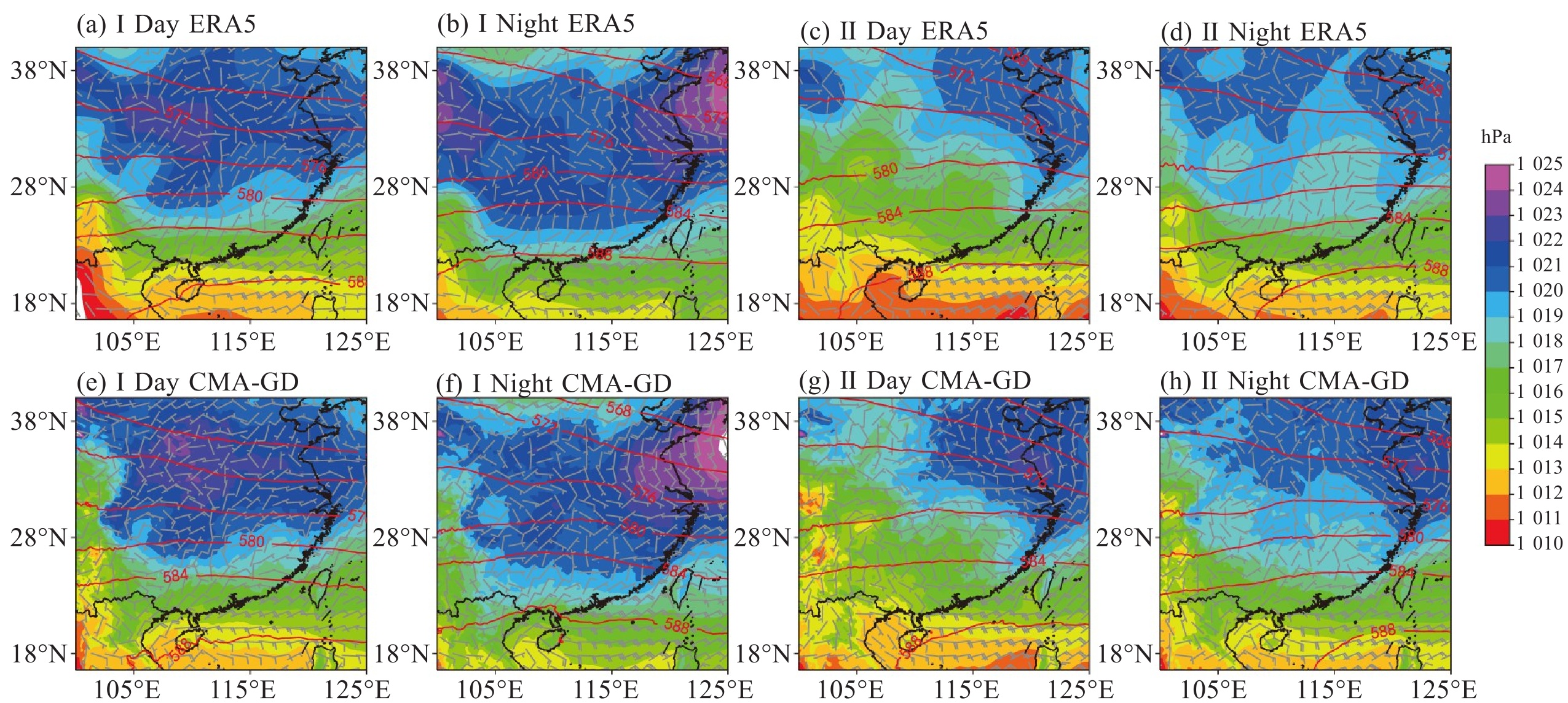
图 5 暴雨发生时1 000 hPa风场(风向杆,单位:m·s-1)、海平面气压场(填色,单位:hPa)及500 hPa高度场(红色等值线,单位:gpm)分布
a~b.Ⅰ区昼/夜;c~d.Ⅱ区昼/夜;e~f.CMA-GD预报场(Ⅰ区昼/夜);g~h.CMA-GD预报场(Ⅱ区昼/夜)。

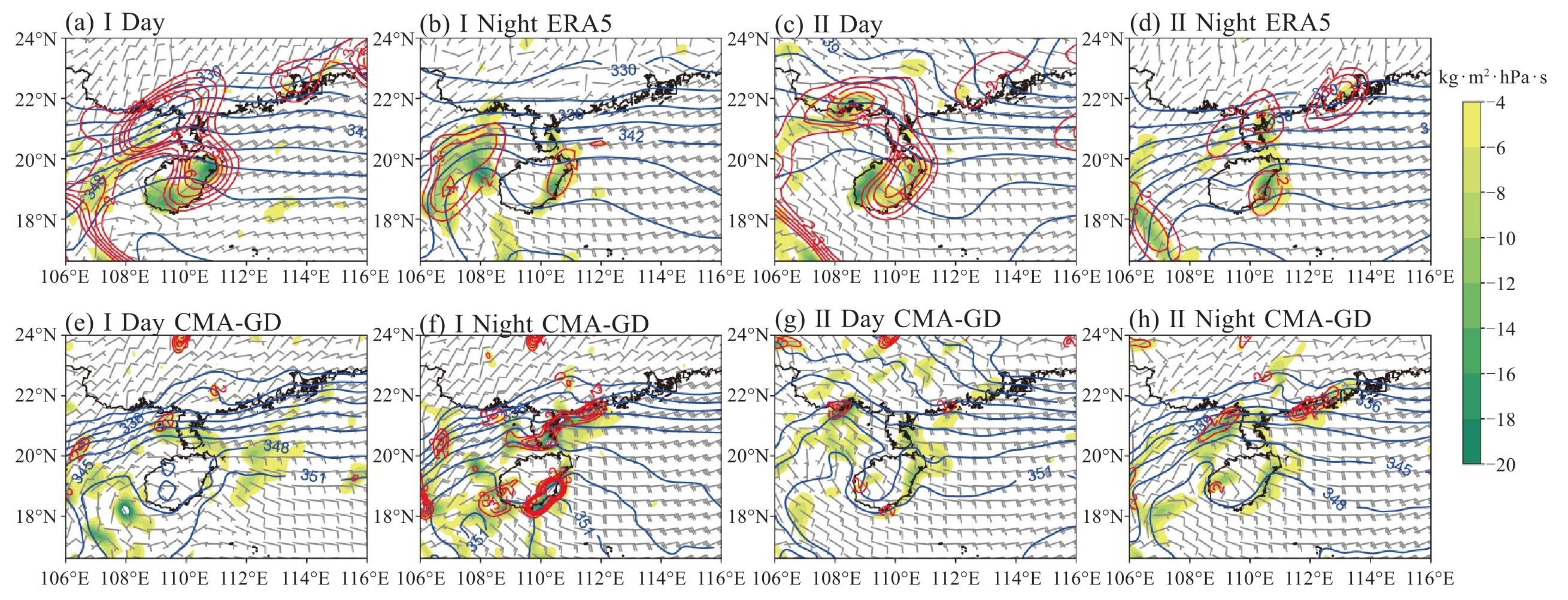
图 6 暴雨发生时1 000 hPa的水汽通量辐合(填色)、假相当位温(蓝色等值线)和锋生(红色等值线)分布
a~b.Ⅰ区昼/夜;c~d.Ⅱ区昼/夜;e~f.CMA-GD预报场(Ⅰ区昼/夜);g~h.CMA-GD预报场(Ⅱ区昼/夜)。

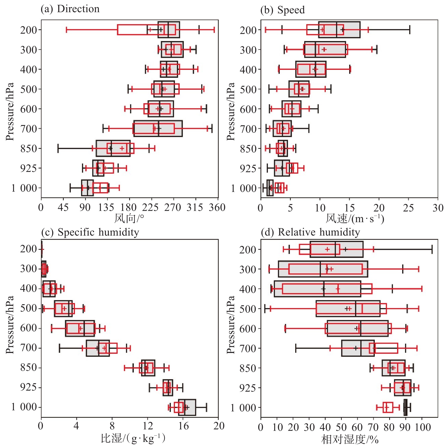
图 7 偏东气流影响下东部丘陵平原地区暴雨过程气象要素垂直分布箱线图对比(2021—2023年春季)
a.风向; b.风速; c.比湿; d.相对湿度(浅灰色:ERA5再分析数据;红色:CMA-GD 24 h预报)。

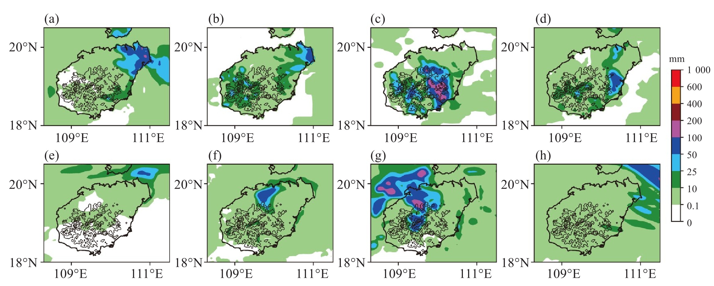
图 8 东部地区典型暴雨过程降水实况与模式预报对比(2021—2023年)
a~d.2023年3月27日、2021年4月9日、2023年5月9日、2023年3月29日24小时累积降水实况;e~h.CMA-GD模式24 h降水预报。

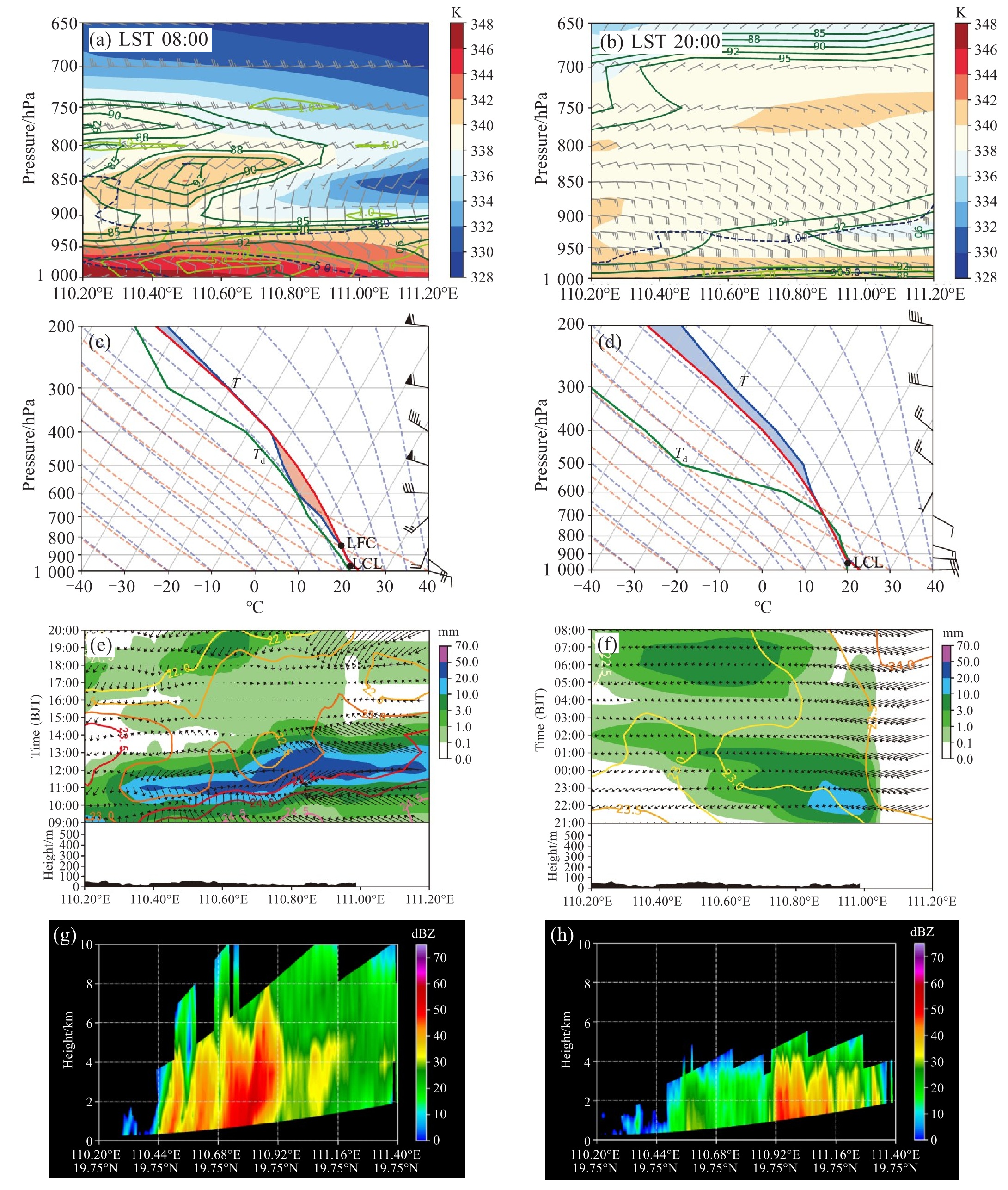
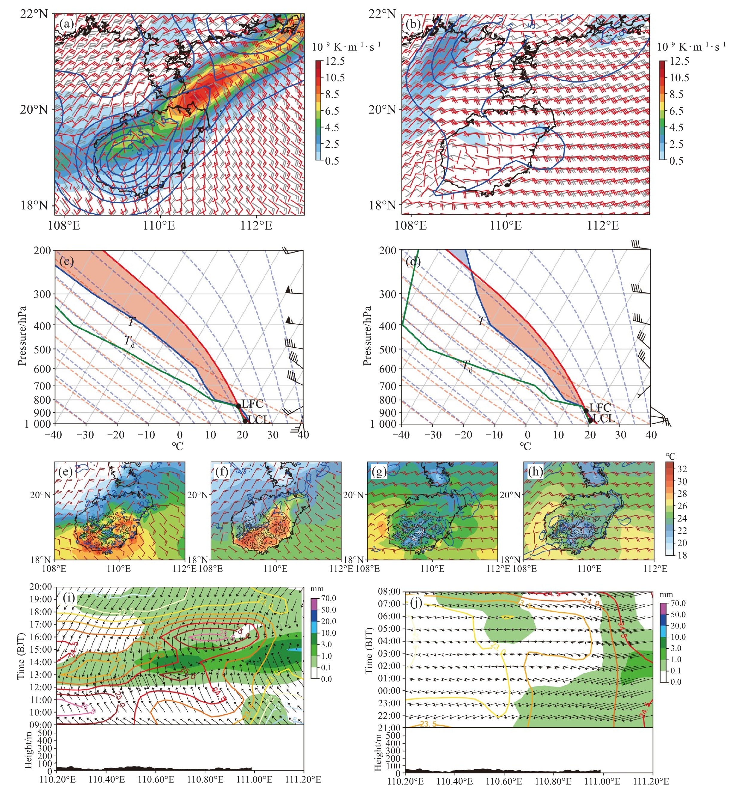
图 9 海南岛Ⅰ区两次暴雨过程(昼/夜)多尺度观测与热动力结构对比
a~b.沿a—b线的热力-动力垂直剖面(左:2023年3月27日08:00;右:2021年4月9日20:00),包括散度(深蓝色虚线)、相对湿度(深绿色实线)、锋生(草绿色实线)、假相当位温θse(填色)和风场矢量;c~d.暴雨区a点的实况探空曲线,时次分别与a、b对应;e~f.沿a—b线的降水2m、2 m气温和10 m风场随时间的演变,黑色阴影表示地形(左:2023年3月27日过程;右:2021年4月9日过程);g~h.强回波区雷达反射率垂直剖面(左:2023年3月27日10:30;右:2021年4月9日21:30)。

图 10 海南岛Ⅰ区两次暴雨过程(昼/夜)CMA-GD模式预报与实况对比
a~b.低层风场与锋生强度对比(黑色/红色箭头分别表示ERA5再分析风场和CMA-GD预报风场;填色/蓝色等值线分别表示ERA5锋生强度和CMA-GD锋生预报),分别对应2023年3月27日11:00(925 hPa)和2021年4月9日21:00(1 000 hPa);c~d.a点CMA-GD模式预报探空曲线(左:2023年3月27日08:00;右:2021年4月9日20:00);e~h近地面要素实况与预报对比(填色:CLDAS 1 km 2 m气温;箭头:10 m风场),其中e~f对应2023年3月27日11:00,g~h对应2021年4月9日21:00;i~j.沿a—b线的CMA-GD模式降水预报、2 m气温及10 m风场随时间的演变,黑色阴影表示地形(左:2023年3月27日过程;右:2021年4月9日过程)。

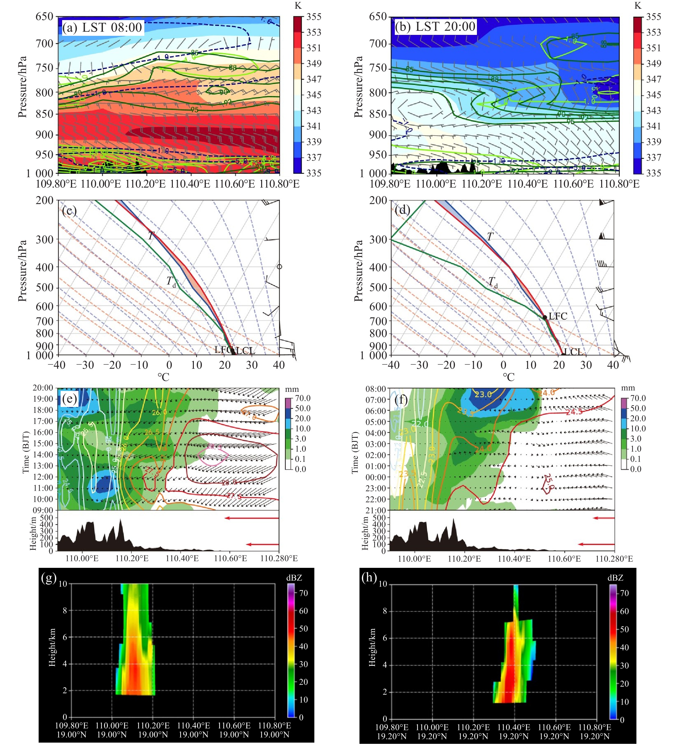
图 12 海南岛Ⅱ区两次暴雨过程(昼/夜)多尺度观测与热动力结构对比
a~b.沿a-b线的热动力垂直剖面(左:2023年5月9日08:00;右:2023年3月28日20:00),含散度(深蓝虚线)、相对湿度(深绿实线)、锋生(草绿实线)、假相当位温θse(填色)及风场矢量;c~d.暴雨区域(c点)实况探空曲线,时次分别与左、右图剖面对应;e~f.沿c—d线的降水、2 m温度及10 m风随时间的演变,黑色阴影表示地形(左:2023年5月9日过程;右:2023年3月29日过程);g~h. 强回波区雷达反射率垂直剖面(左:2023年5月9日11:16;右:2023年3月29日04:00)。

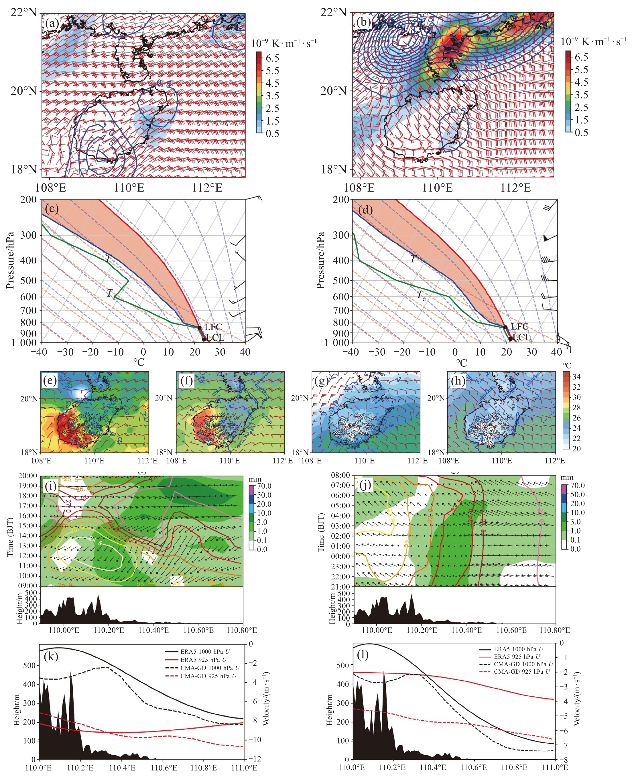
图 13 海南岛Ⅱ区两次暴雨过程(昼/夜)CMA-GD模式预报与实况对比
a~b.低层动力场对比:ERA5再分析与CMA-GD预报的1 000 hPa风场及锋生强度,其中黑色箭头和填色分别表示ERA5再分析风场和锋生强度,红色箭头和蓝色等值线分别表示CMA-GD预报风场和锋生强度;时次分别为2023年5月9日11:00(a)和2023年3月29日02:00(b);c~d.c点CMA-GD模式预报探空曲线(左:2023年5月9日08:00;右:2023年3月28日20:00);e~h近地面要素实况与预报对比:CLDAS 1 km实况和CMA-GD预报,其中填色表示2 m气温,箭头表示10 m风场;时次分别为2023年5月9日11:00(e、f)和2023年3月29日02:00(g、h);i~j. 沿c—d线的降水、2 m气温及10 m风场随时间的演变,黑色阴影表示地形(左:2023年5月9日过程;右:2023年3月29日过程);k~l.沿垂直于地形方向的纬向风水平-垂直分布对比:ERA5再分析(实线)与CMA-GD预报(虚线)在1 000~925 hPa的纬向风(u)分布差异,时次分别为2023年5月9日11:00(k)和2023年3月29日02:00(l)。
-
[1] 张文龙, 崔晓鹏, 王迎春, 等. 对流层低层偏东风对北京局地暴雨的作用[J]. 大气科学, 2013, 37(4): 829-840. [2] 孙继松. 气流的垂直分布对地形雨落区的影响[J]. 高原气象, 2005, 24(1): 62-69. [3] 陈军, 何为, 杨群, 等. 低层偏东气流对贵州梵净山东侧强降水的作用[J]. 暴雨灾害, 2020, 39(2): 158-166. [4] 蒋贤玲, 任福民, 马柱国, 等. 2014年两次路径相似热带气旋降水特征及其成因的对比[J]. 地球物理学报, 2017(4): 1305-1320. [5] 冯文, 吴俞, 赵付竹, 等. 海南岛不同强弱秋汛期暴雨的环流形势和动力特征分析[J]. 气象科学, 2017, 37(6): 784-796. [6] 冯文, 周玲丽, 肖潺, 等. 海南岛秋汛期降水的时空分布特点及其环流特征分析[J]. 热带气象学报, 2016, 32(4): 533-545. [7] 冯文, 符式红, 吴俞. 南海中北部秋季低空偏东急流分布特征及其形成的机制[J]. 热带气象学报, 2015, 31(2): 247-254. [8] 冯文, 符式红, 赵付竹. 近10年海南岛后汛期特大暴雨环流配置及其异常特征[J]. 气象, 2015, 41(2): 143-152. [9] 杨薇, 冯文, 李勋. 微物理过程和积云参数化方案对海南岛秋季暴雨模拟的影响[J]. 暴雨灾害, 2017, 36(1): 8-17. [10] 曾敏, 王咏青, 冯文. 海南岛冬季暴雨的时空分布及大尺度环流场特征分析[J]. 气象科学, 2023, 43(5): 589-599. [11] 冯文. 热带扰动和弱冷空气引发的海南岛秋汛期特大暴雨时空分布特征及形成机制研究[D]. 南京: 南京信息工程大学, 2020. [12] 潘旸, 谷军霞, 宇婧婧, 等. 中国区域高分辨率多源降水观测产品的融合方法试验[J]. 气象学报, 2018, 76(5): 755-766. [13] 师春香, 潘旸, 谷军霞, 等. 多源气象数据融合格点实况产品研制进展[J]. 气象学报, 2019, 77(4): 774-783. [14] 林晓霞, 冯业荣, 陈子通, 等. 华南区域高分辨率数值模式前汛期预报初步评估[J]. 热带气象学报, 2021, 37(4): 656-668. [15] Zhang Y X, Chen Z T, Meng W G, et al. Applicability of temperature discrete equation to NMRF boundary layer scheme in GRAPES model [J]. Journal of Tropical Meteorology, 2022, 28(1): 12-28. [16] Zhou T J, Yu R C, Chen H M, et al. Summer precipitation frequency, intensity, and diurnal cycle over China: a comparison of satellite data with rain gauge observations[J]. Journal of Climate, 2008, 21(16): 3997-4010. [17] Chen H M, Yu R C, Li J, et al. Why nocturnal long-duration rainfall presents an eastward-delayed diurnal phase of rainfall down the Yangtze River valley[J]. Journal of Climate, 2010, 23(4): 905-917. [18] Zhu L, Meng Z Y, Zhang F Q, et al. The influence of sea- and land-breeze circulations on the diurnal variability in precipitation over a tropical island[J]. Atmospheric Chemistry and Physics, 2017, 17(21): 13213-13232. [19] Zhu L, Chen X C, Bai L Q. Relative roles of low-level wind speed and moisture in the diurnal cycle of rainfall over a tropical island under monsoonal flows[J]. Geophysical Research Letters, 2020, 47(8): e2020GL087467. [20] 吴俞, 李玉梅, 李勋, 等. 海南岛暖季区域数值模式降水精细化预报检验[J]. 气象, 2023, 49(2): 235-248. [21] Feng X, Wu Y, Yang W, et al. Zoning evaluation of hourly precipitation in high-resolution regional numerical models over Hainan Island[J]. Journal of Tropical Meteorology, 2023, 29(4): 460-472. [22] 孙继松. 短时强降水和暴雨的区别与联系[J]. 暴雨灾害, 2017, 36(6): 498-506. [23] 高守亭, 周玉淑, 张万诚, 等. 垂直运动研究进展及新型垂直运动方程[J]. 大气科学, 2023, 47(4): 1039-1049. [24] 高守亭, 周玉淑, 冉令坤. 我国暴雨形成机理及预报方法研究进展[J]. 大气科学, 2018, 42(4): 833-846. [25] 冯文, 吴冰雪, 杨薇. 海南岛秋汛期特大暴雨局地锋生的特征及其对对流系统发展的影响[J]. 大气科学学报, 2023, 46(2): 271-282. [26] Chen X C, Zhang F Q, Zhao K. Diurnal variations of the land-sea breeze and its related precipitation over South China[J]. Journal of the Atmospheric Sciences, 2016, 73(12): 4793-4815. [27] Bai L Q, Chen G X, Huang L. Convection initiation in monsoon coastal areas (South China)[J]. Geophysical Research Letters, 2020, 47(11): e2020GL087035. [28] Bai L Q, Chen G X, Huang L. Image processing of radar mosaics for the climatology of convection initiation in South China[J]. Journal of Applied Meteorology and Climatology, 2020, 59(1): 65-81. [29] Zhong S X, Chen Z T, Wang G, et al. Improved forecasting of cold air outbreaks over southern China through orographic gravity wave drag parameterization[J]. Journal of Tropical Meteorology, 2016, 22(4): 522-534. [30] Zhu K F, Xue M, Zhou B W, et al. Evaluation of real-time convection-permitting precipitation forecasts in China during the 2013-2014 summer season[J]. Journal of Geophysical Research: Atmospheres, 2018, 123(2): 1037-1064. [31] Zhu K F, Yu B Y, Xue M, et al. Summer season precipitation biases in 4 km WRF forecasts over Southern China: diagnoses of the causes of biases[J]. Journal of Geophysical Research: Atmospheres, 2021, 126(23): e2021JD035530. [32] Lin X X, Jian Y T, Xu D S, et al. The source of low-level wind forecast error and its influence on simulating the Guangzhou extreme rainfall on 7 May, 2017 using high-resolution TRAMS model[J]. Meteorology and Atmospheric Physics, 2025, 137(1): 10-19. -

 下载:
下载:
 点击查看大图
计量
- 文章访问数: 2
- HTML全文浏览量: 0
- PDF下载量: 0
- 被引次数: 0
 粤公网安备 4401069904700003号