



Evaluation of the China Meteorological Administration Weather Radar Mosaic System V3.0 Hourly Precipitation Product Based on A Network of Rain Gauges: A Case Study of Guangxi Zhuang Autonomous Region
-
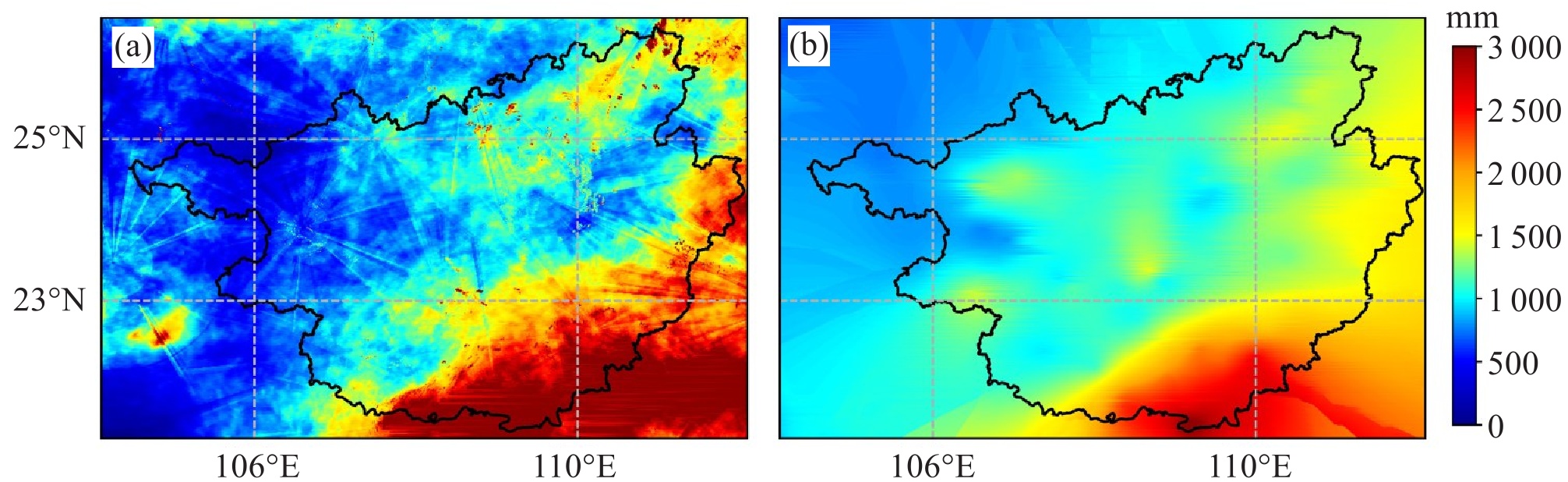
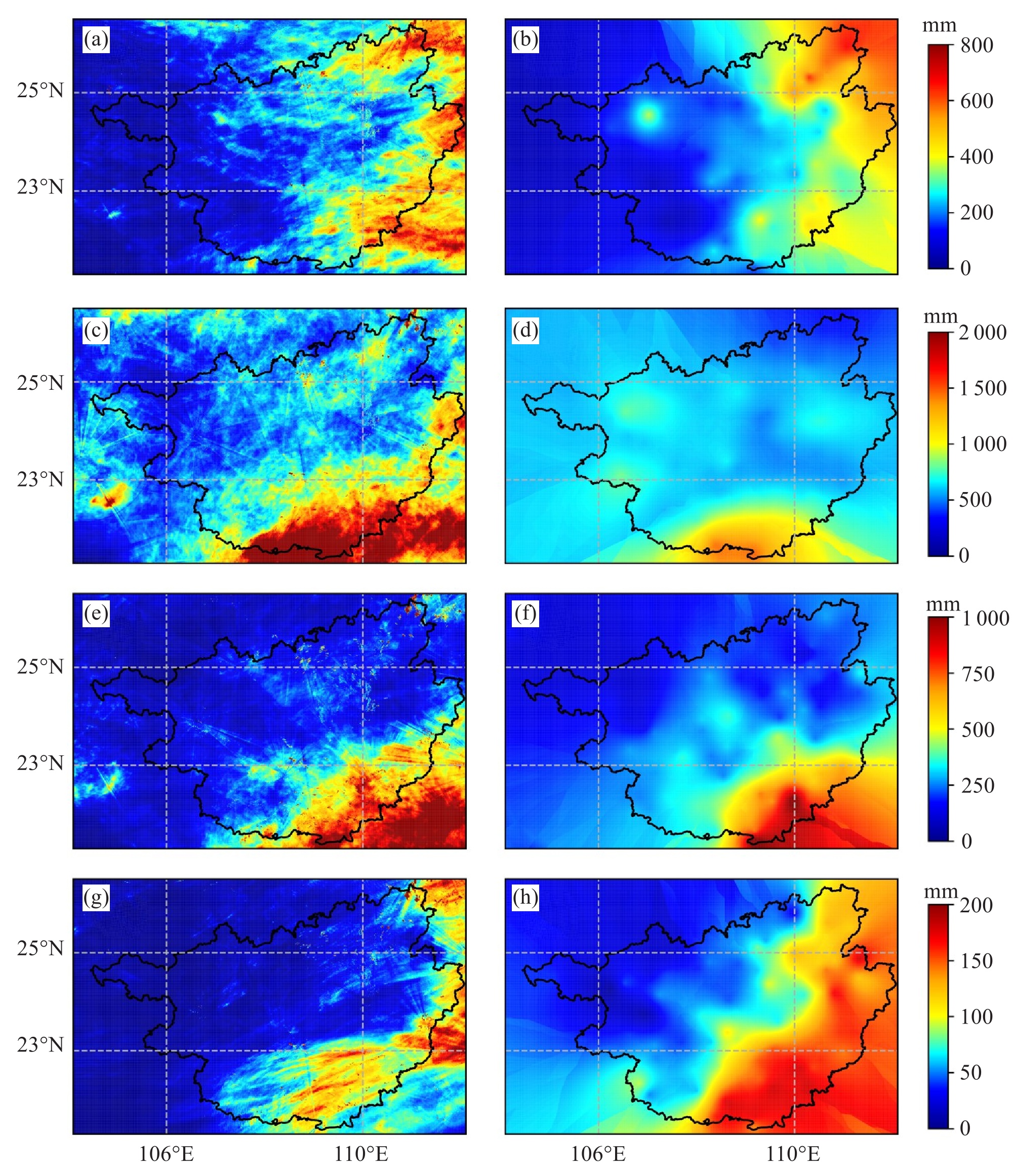
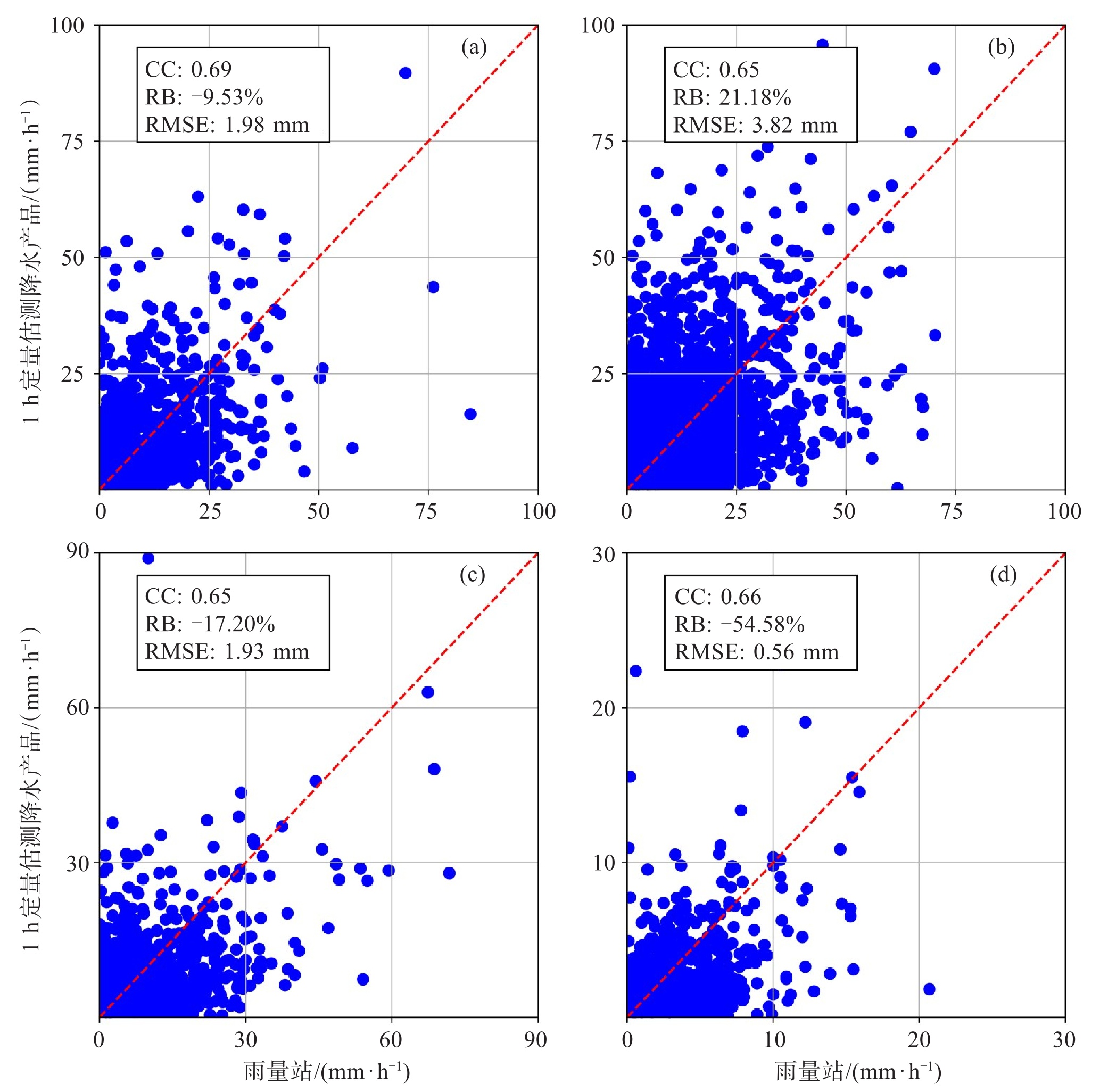
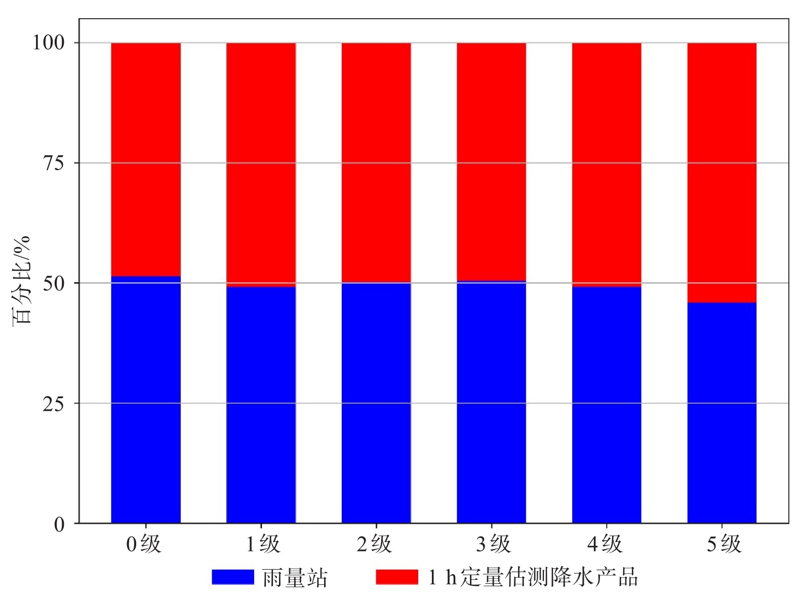
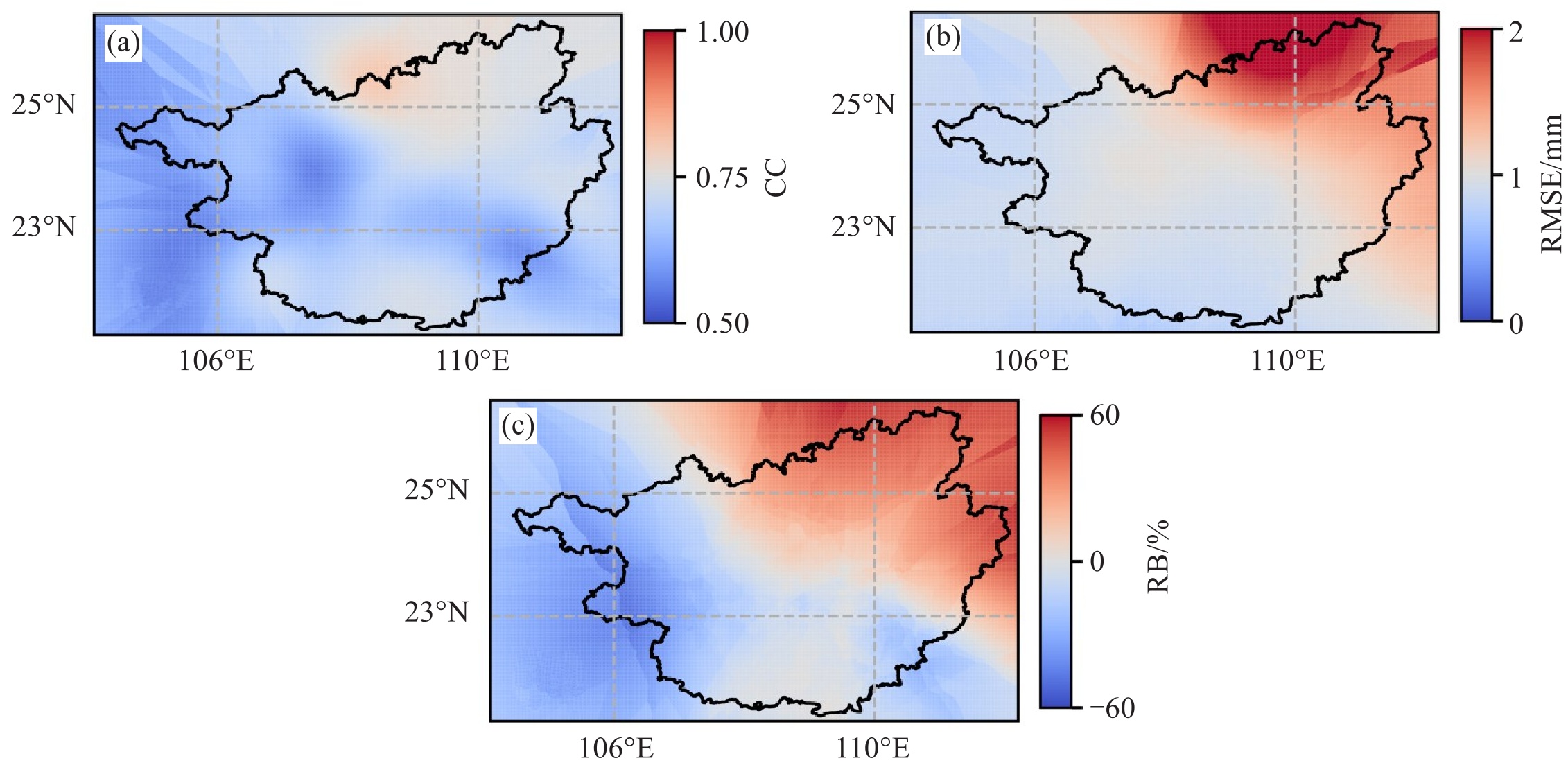
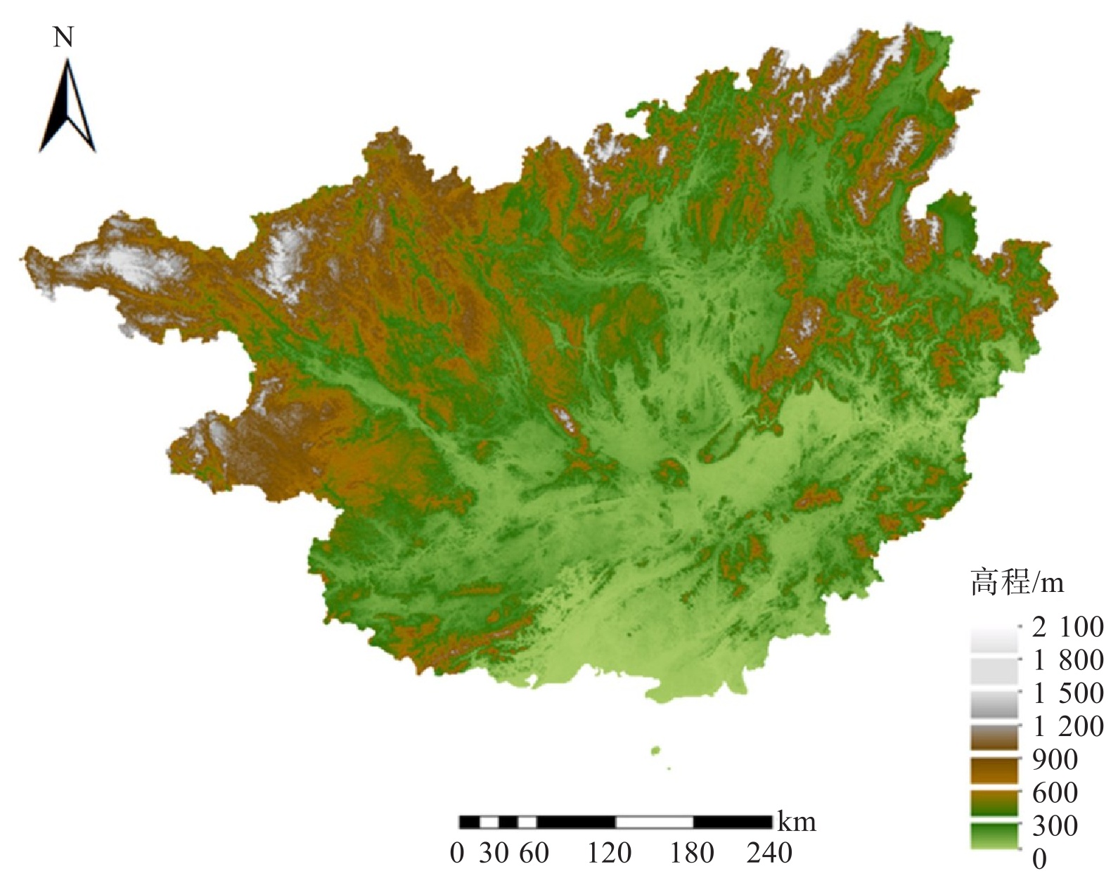
摘要: 准确监测和预报降水对于减灾防灾、水资源规划以及应对全球变化具有重要意义。最新升级的中国气象局天气雷达拼图系统V3.0在降水业务监测中发挥着重要作用,但尚缺乏针对降水产品的精细化检验。以广西壮族自治区为例,利用国家标准气象站的雨量计观测数据,对2023年1月1日—12月31日的天气雷达拼图系统V3.0逐小时降水产品进行评估,为产品的优化升级提供科学依据,结果表明:(1)基于逐小时定量降水估测产品的年降水量分布情况与雨量计观测结果一致,但空间局部存在系统性偏差,对北部湾沿岸地区年降水量高估约500 mm,同时低估了百色市周围地区的降水。(2)逐小时定量估测降水产品对不同等级的降水事件频次的估测与雨量计观测结果较为一致;在小雨级别中表现良好,在强降水事件中表现为低估。(3)降水产品的精度在空间上呈现出一定差异,在广西东北部的桂林及其周边地区、西部百色等地的误差较高,相对偏差接近60%,而在北部湾沿岸地区的模拟表现相对更好。Abstract: Accurate precipitation monitoring and forecasting are essential for disaster mitigation, water resource management, and addressing global climate challenges. The China Meteorological Administration's upgraded Weather Radar Mosaic System V3.0 (CWRMS V3.0) plays a pivotal role in operational precipitation monitoring, yet comprehensive validation of its quantitative precipitation estimation (QPE) products remains limited. Focusing on the Guangxi Zhuang Autonomous Region, this study evaluates the system's 1-hour QPE products from 1 January to 31 December, 2023, using rain gauge observations from national meteorological stations. The results reveal three key findings: (1) The annual precipitation spatial distribution derived from QPE generally aligns with observations but exhibits distinct regional biases, including overestimation of approximately 500 mm in the coastal areas of the Beibu Gulf and an underestimation around Baise City. (2) The hourly QPE products demonstrate that the system has robust detection capabilities across various precipitation intensities, correlating well with the rain gauge records. However, while performance is satisfactory for light rains, the system exhibits a pronounced negative bias for heavy precipitation events. (3) Spatial disparities in accuracy are evident, with notably high errors (relative bias up to 60%) in northeastern Guilin and western Baise, contrasting with relatively lower errors observed in coastal regions.
-
表 1 误差指标计算公式
误差指标 公式 CC $ \frac{\sum_{i=1}^{N}\left(X_i-\bar{X}\right)\left(Y_i-\bar{Y}\right)}{\sqrt{\sum_{i=1}^{N}\left(X_i-\bar{X}\right)^2}\sqrt{\sum_{i=1}^{N}\left(Y_i-\bar{Y}\right)^2}} $ (2) RMSE $ \sqrt{\frac{1}{N}\sum_{i=1}^{N}\left(X_i-Y_i\right)^2} $ (3) RB $ \frac{\sum_{i=1}^{N}\left(X_i-Y_i\right)}{\sum_{i=1}^{N}Y_i} \times 100\% $ (4)  下载: 导出CSV
表 2 降水等级划分
等级 划分标准/(mm·h-1) 雨量计观测事件/次 0级 < 0.1 689 004 1级 0.1~2.0 51 659 2级 2.0~5.0 7 788 3级 5.0~10.0 3 448 4级 10.0~20.0 1 709 5级 > 20.0 770
下载: 导出CSV
表 4 POD、FAR、CSI计算公式
指标 计算公式 POD $ \frac{\rm TP}{\rm TP + \rm FN} $ (5) FAR $ \frac{\rm FP}{\rm TP + \rm FP} $ (6) CSI $ \frac{\rm TP}{\rm TP + \rm FP + \rm FN} $ (7)
下载: 导出CSV
表 5 不同降水等级下的误差指标
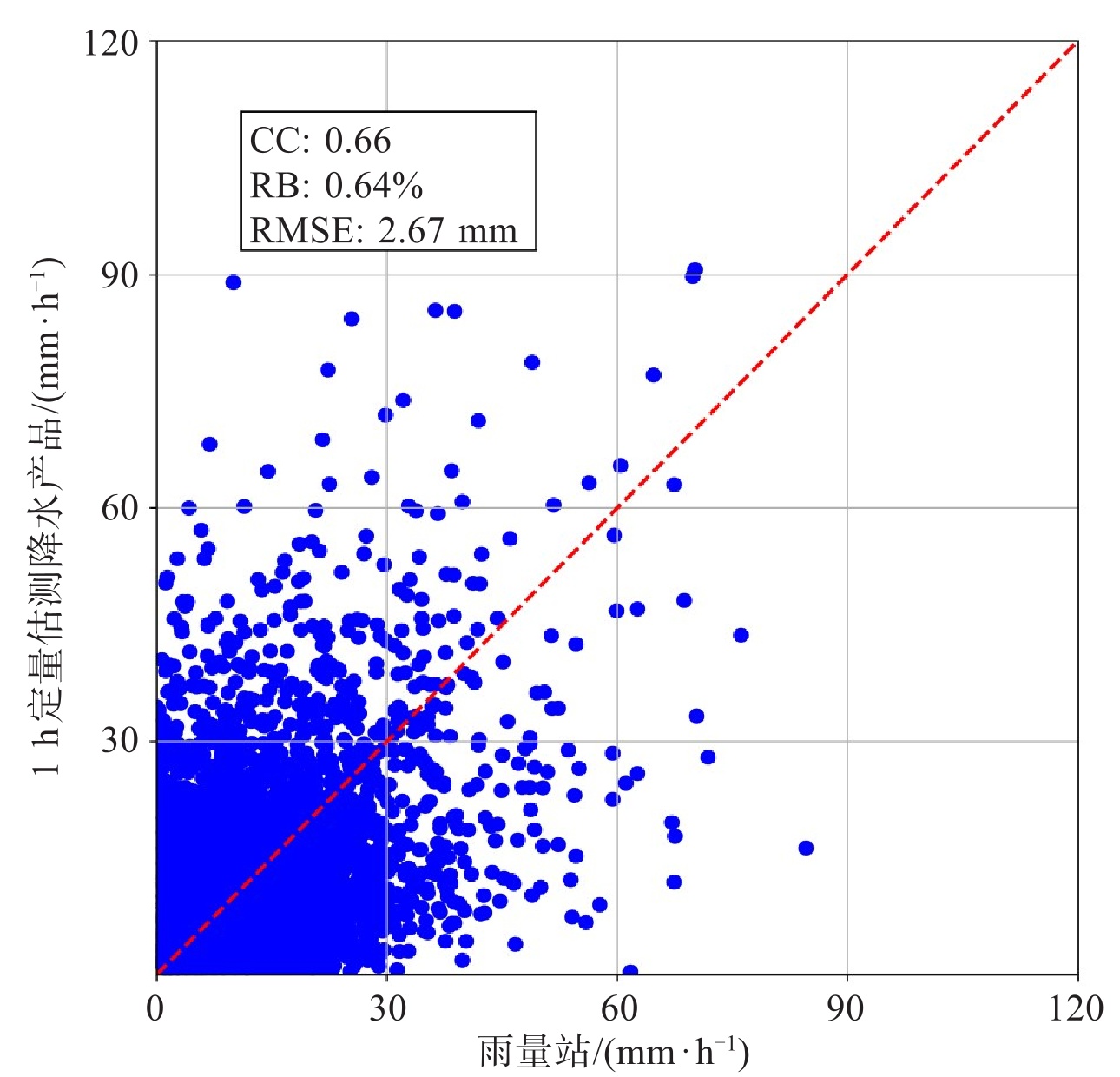
指标 1级 2级 3级 4级 5级 CC 0.66 0.25 0.13 0.20 0.35 RMSE/mm 2.67 1.88 4.04 10.16 18.25 RB/% 0.64 22.89 -11.36 -30.48 -32.49
下载: 导出CSV
表 6 多种降水产品的统计指标
指标 1 h定量估测降水产品 GSMaP IMERG CMPAS POD 0.68 0.25~0.45 0.25~0.45 > 0.65 FAR 0.57 > 0.65 0.45~0.65 < 0.25 CSI 0.36 < 0.25 0.25~0.45 > 0.45
下载: 导出CSV
-
[1] Trenberth K E. Changes in precipitation with climate change[J]. Climate Research, 2011, 47(1): 123-138. [2] Li Z, Yang D W, Hong Y. Multi-scale evaluation of high-resolution multi-sensor blended global precipitation products over the Yangtze River[J]. Journal of Hydrology, 2013, 500: 157-169. [3] Li H R, Moisseev D, Luo Y L, et al. Assessing specific differential phase (KDP)-based quantitative precipitation estimation for the record-breaking rainfall over Zhengzhou city on 20 July 2021[J]. Hydrology and Earth System Sciences, 2023, 27(5): 1033-1046. [4] Xu J T, Ma Z Q, Yan S K, et al. Do ERA5 and ERA5-land precipitation estimates outperform satellite-based precipitation products? A comprehensive comparison between state-of-the-art model-based and satellite-based precipitation products over mainland China[J]. Journal of Hydrology, 2022, 605: 127353. [5] Lavers D A, Simmons A, Vamborg F, et al. An evaluation of ERA5 precipitation for climate monitoring[J]. Quarterly Journal of the Royal Meteorological Society, 2022, 148(748): 3152-3165. [6] Wang J X, Petersen W A, Wolff D B. Validation of satellite-based precipitation products from TRMM to GPM[J]. Remote Sensing, 2021, 13(9): 1745. [7] He Z H, Yang L, Tian F Q, et al. Intercomparisons of rainfall estimates from TRMM and GPM multisatellite products over the upper Mekong River Basin[J]. Journal of Hydrometeorology, 2017, 18(2): 413-430. [8] Bai L, Shi C X, Li L H, et al. Accuracy of CHIRPS satellite-rainfall products over mainland China[J]. Remote Sensing, 2018, 10(3): 362. [9] Zhong R D, Chen X H, Lai C G, et al. Drought monitoring utility of satellite-based precipitation products across mainland China[J]. Journal of Hydrology, 2019, 568: 343-359. [10] Chen Y H, Xu M H, Wang Z L, et al. Applicability of two satellite-based precipitation products for assessing rainfall erosivity in China[J]. Science of the Total Environment, 2021, 757: 143975. [11] 陈雷. 基于长三角地区雷达拼图的定量降水预报(QPF)研究及业务应用[M]. [12] Wang R, Chu H, Liu Q Y, et al. Application of Machine Learning Techniques to Improve Multi-radar Mosaic Precipitation Estimates in Shanghai[J]. Atmosphere, 2023, 14(9): 1364. [13] 金晓龙, 邵华, 张弛, 等. GPM卫星降水数据在天山山区的适用性分析[J]. 自然资源学报, 2016, 31(12): 2074-2085. [14] Ma Y Z, Tang G Q, Long D, et al. Similarity and error intercomparison of the GPM and its predecessor-TRMM multisatellite precipitation analysis using the best available hourly gauge network over the Tibetan Plateau[J]. Remote Sensing, 2016, 8(7): 569. [15] Oliver M A, Webster R. Kriging: a method of interpolation for geographical information systems[J]. International Journal of Geographical Information Systems, 1990, 4(3): 313-332. [16] 郭家力, 丁光旭, 杨旭, 等. 多源卫星降水产品在长江流域的时空精度对比[J]. 南水北调与水利科技(中英文), 2022, 20(2): 230-242, 252. [17] 卓健, 任晓炜, 黄珩, 等. 四种融合降水产品在广西适用性评估[J]. 河南科学, 2024, 42(5): 705-713. [18] Tang G Q, Clark M P, Papalexiou S M, et al. Have satellite precipitation products improved over last two decades? A comprehensive comparison of GPM IMERG with nine satellite and reanalysis datasets[J]. Remote Sensing of Environment, 2020, 240: 111697. [19] 朱慧琴, 陈生, 李晓俞, 等. GPM卫星降水产品在"7·21"河南极端暴雨过程中的误差评估[J]. 水利水电技术(中英文), 2022, 53(1): 1-13. [20] 旷兰, 田茂举, 李强, 等. 川渝地区汛期逐小时降水融合产品误差分析[J]. 中国农业气象, 2023, 44(10): 953-963. [21] 勾亚彬, 刘黎平, 杨杰, 等. 基于雷达组网拼图的定量降水估测算法业务应用及效果评估[J]. 气象学报, 2014, 72(4): 731-748. [22] 纪永明, 蒋大凯, 陈传雷, 等. 基于雷达组网拼图的定量降水反演Ⅰ—动态Z-I关系法[J]. 气象与环境学报, 2018, 34(4): 18-25. -

 点击查看大图
图(8) / 表(6)
计量
- 文章访问数: 2
- HTML全文浏览量: 0
- PDF下载量: 0
- 被引次数: 0
 粤公网安备 4401069904700003号