



Analysis of an Extreme Downburst Event Along the Yangtze River in Anhui
-
摘要: 2023年6月10日皖江地区受强雷暴天气影响, 引发下击暴流, 造成池州香山站出现本地区有历史记录以来最大瞬时风速$ 46.6 \mathrm{~m} \cdot \mathrm{~s}^{-1} $(15级)。利用地面加密自动站分钟级资料、探空、雷达、EC再分析资料等, 对此次过程进行分析, 结果表明:(1)皖江地区处于东北冷涡底部, 中高层具有明显"前倾槽"结构, 整层温湿廓线呈"X"型, 850 hPa和500 hPa温差达30℃, 对流有效位能(CAPE)达$ 2869.9 \mathrm{~J} \cdot \mathrm{~kg}^{-1} $, 近地层与500 hPa"对头风"明显;(2)位于皖东对流主体西南方向的庐江西北侧地面中尺度辐合线, 触发两个雷暴单体并向东南方向移动, 受铜陵西侧较强的冷池出流边界影响, 得到快速发展;(3)两个雷暴单体在池州香山站附近合并, 强度得到进一步加强, 雷达速度图上出现大风速核, 并伴随低层辐散, 导致池州香山站(15级)、铜陵同乐站(13级)和朱村站(11级)出现下击暴流;(4)对比分析三站雷达回波、分钟气象要素等变化, 瞬时风速最大的香山站中层湿度最小, 有明显的夹卷作用, 使负浮力最强, 下沉对流有效位能(DCAPE)值最大且增速快, 导致该站出现最强的下沉气流和明显的地面"冷池"效应, 同时香山站降水强度较大, 降水粒子拖曳对极端下击暴流的维持起到一定作用。Abstract: On 10 June 2023, a strong thunderstorm activity affected the Yangtze River basin in Anhui Province, triggering several downbursts with a maximum instantaneous wind speed of $ 46.6 \mathrm{~m} \cdot \mathrm{~s}^{-1} $(grade 15)recorded at Xiangshan Station, Chizhou. Using minute-by-minute automatic weather station data, radiosonde soundings, radar observations, and ERA5 reanalysis data, a comprehensive diagnostic analysis of this event was conducted. The results reveal that: (1)The area was located at the bottom of the Northeast Cold Vortex, with a pronounced"forward-tilted trough"structure in the middle and upper troposphere. The temperature and humidity profiles of the entire layer exhibited a distinctive"X-shaped" configuration. The temperature difference between 850 hPa and 500 hPa reached 30℃, CAPE value attained $ 2869.9 \mathrm{~J} \cdot \mathrm{~kg}^{-1} $, and a pronounced"headwind"was observed between the near-surface layer and 500 hPa; (2)A surface mesoscale convergence line, located in the northwest of Lujiang and southwest of the main convective cell in eastern Anhui, initiated two thunderstorm cells that propagated southeastward. These cells underwent rapid intensification upon interaction with the strong cold pool outflow boundary on the west side of Tongling; (3)The two thunderstorm cells merged near Xiangshan Station, Chizhou, resulting in further intensification. Large wind speed cores appeared on radar velocity display, accompanied by low-level divergence, leading to downburst at three stations: Xiangshan Station(grade 15), Tongle Station in Tongling(grade 13), and Zhucun Station(grade 11);(4)Comparative analysis of the radar echoes and minute-by-minute meteorological elements across three stations revealed that the Xiangshan station, which recorded the highest instantaneous wind speed, exhibited the lowest mid-level humidity. Enhanced entrainment effect induced the strongest negative buoyancy and the largest downdraft CAPE (DCAPE)values, driving the strongest sinking airflow and the most pronounced surface"cold pool"effect. Additionally, the relatively high precipitation intensity at Xiangshan station meant that precipitation particle drag played a certain role in sustaining the extreme downburst.
-
Key words:
- downburst /
- entrainment and negative buoyancy /
- precipitation particle drag /
- cold pool
-

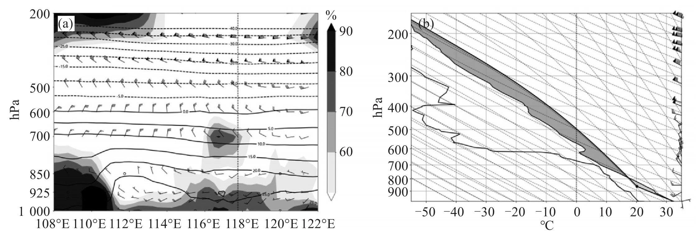
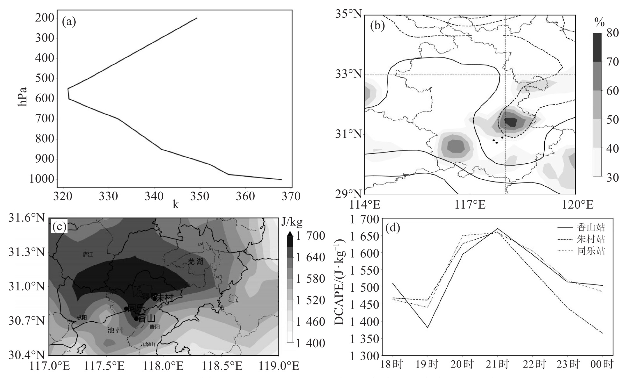
图 2 2023年6月10日08时相对湿度(填色, 单位:%)、温度(实线, 单位:℃)和风场(风羽, 单位:m ⋅ s-1)沿香山站所在纬度(30.75° N)的垂直剖面图(a)和20时安庆站的探空图(b)
a中虚线为香山所在经度;b中实线自左向右分别为露点层结曲线、温度层结曲线和状态曲线, 阴影区为CAPE, 实心圆点为抬升凝结高度。

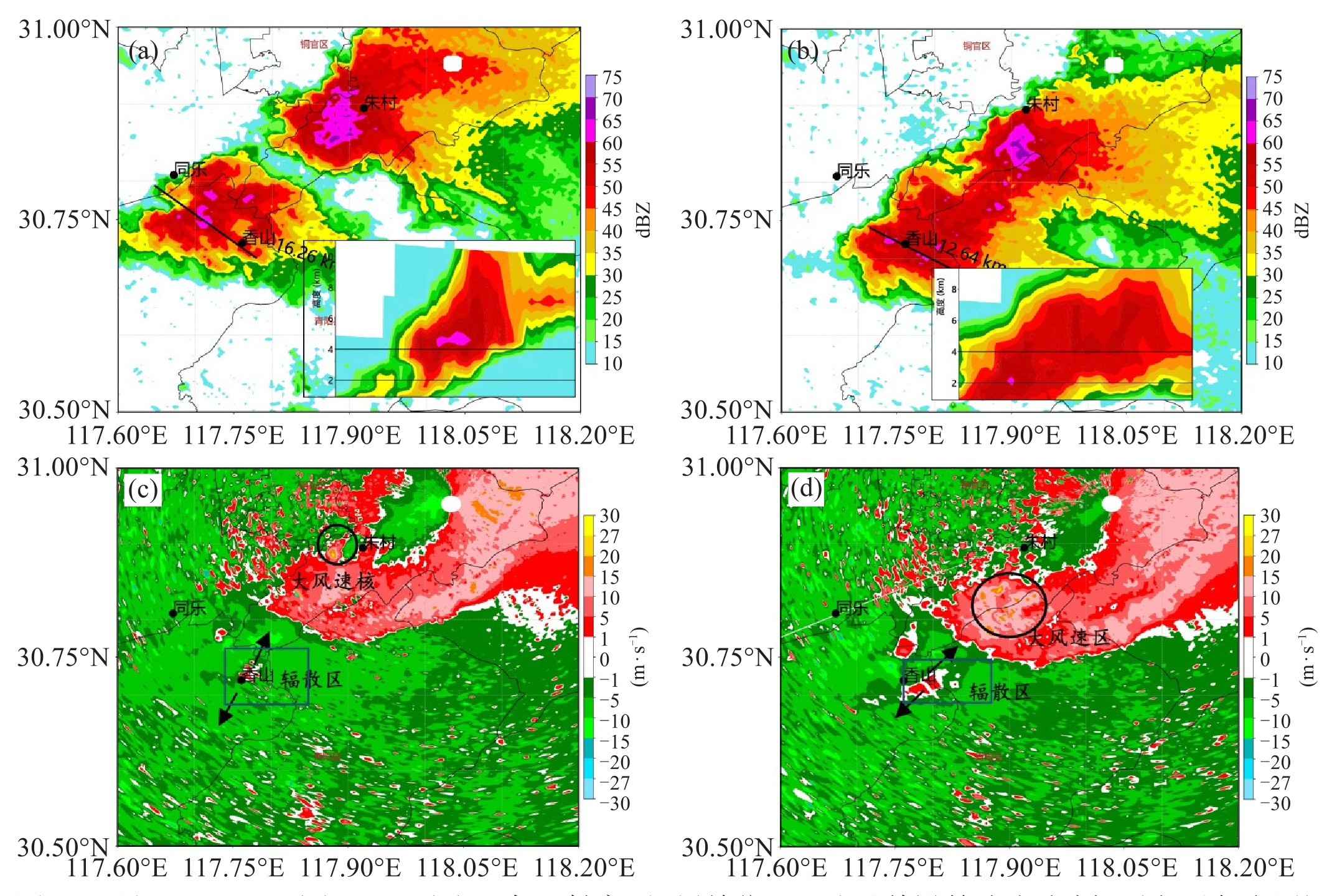
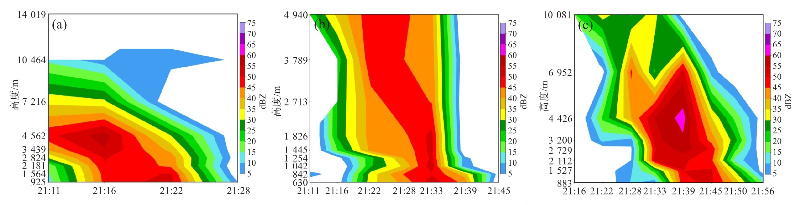
图 4 6月10日21:28(a)、21:39(b)组合反射率因子(单位:dBZ)及其沿箭头方向剖面(右下角小图)和21:33(c)、21:39(d)0.5°仰角径向速度(单位:m ⋅ $ \mathrm{s}^{-1} $)
c和d中圆形范围为大风速核位置, 长方形框范围为辐散区位置, 箭头为辐散方向。

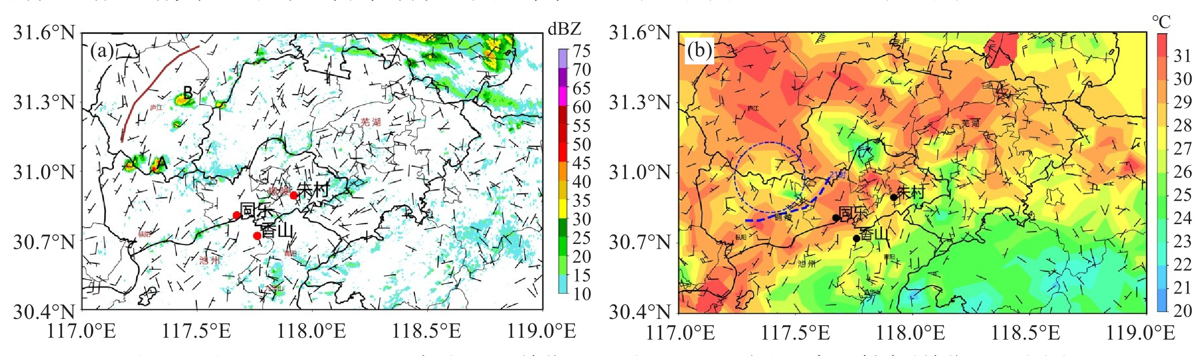
图 5 6月10日19:00地面风场(风羽, 单位:$ \mathrm{m} \cdot \mathrm{s}^{-1} $)和19:46雷达组合反射率(单位:dBZ)(a)、21:00地面风场(风羽, 单位:$ \mathrm{m} \cdot \mathrm{s}^{-1} $)和温度场(单位:$ {}^{\circ} \mathrm{C} $)(b)
a中棕实线为地面辐合线。b中蓝虚线为冷池前沿, 蓝圆形虚线范围为冷池。

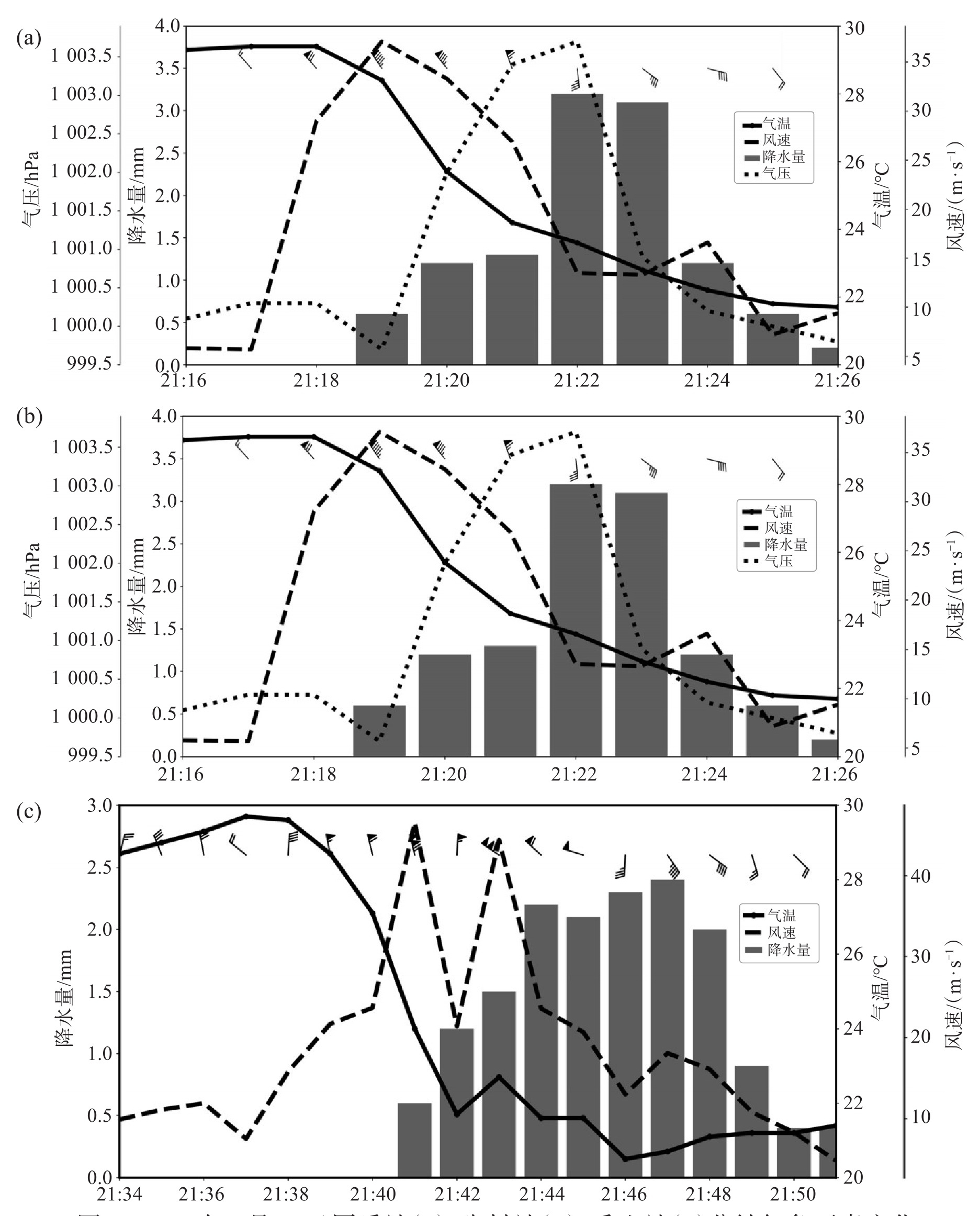
图 7 2023年6月10日同乐站(a)、朱村站(b)、香山站(c)分钟气象要素变化
柱形为降水量(单位:mm), 实线为气温(单位:℃), 虚线为风速(单位:m ⋅ s-1), 点线为气压(单位:hPa)。
-
[1] Fujita T T, Byers H R. Spearhead echo and downburst in the crash of an airliner[J]. Monthly Weather Review, 1977, 105(2): 129-146. [2] Roberts R D, Wilson J W. A proposed microburst nowcasting procedure using single-Doppler radar[J]. Journal of Applied Meteorology, 1989, 28(4): 285-303. [3] Eilts M D, Johnson J T, Mitchell E D, et al. Damaging downburst prediction and detection algorithm for the WSR-88D[C]//18th Conference on Severe Local Storms. San Francisco, CA: American Meteorological Society, 1996: 541-545. [4] 俞小鼎, 张爱民, 郑媛媛, 等. 一次系列下击暴流事件的多普勒天气雷达分析[J]. 应用气象学报, 2006, 17(4): 385-393. [5] 崔讲学, 张家国, 王仁乔, 等. 武汉一次下击暴流天气的成因分析[J]. 暴雨灾害, 2007, 26(4): 369-371. [6] 王艳兰, 王娟, 伍静, 等. 桂林市2019年"3.21"极端大风与"4.24"致灾冰雹过程特征对比分析[J]. 热带气象学报, 2021, 37(2): 175-185. [7] 禹梁玉, 王啸华, 顾荣直, 等. 江苏一次下击暴流过程致灾大风成因分析[J]. 热带气象学报, 2021, 37(5): 801-811. [8] 郑永光, 周康辉, 盛杰, 等. 强对流天气监测预报预警技术进展[J]. 应用气象学报, 2015, 26(6): 641-657. [9] 李彩玲, 蔡康龙, 黄先香, 等. 桂林一次强下击暴流成因分析[J]. 气象, 2021, 47(2): 242-252. [10] 陈晓欣, 俞小鼎, 王秀明. 中国大范围雷暴大风事件(Derechos)研究: 时空分布、环境背景和对流系统形态特征[J]. 气象学报, 2022, 80(1): 67-81. [11] 汤兴芝, 黄治勇, 王文玉, 等. 鄂东春季两次极端雷暴大风过程环境及雷达回波特征对比分析[J]. 气象科学, 2024, 44(5): 961-973. [12] Doswell C A Ⅲ. The distinction between large-scale and mesoscale contribution to severe convection: a case study example[J]. Weather and Forecasting, 1987, 2(1): 3-16. [13] Wilson J W, Megenhardt D L. Thunderstorm initiation, organization, and lifetime associated with Florida boundary layer convergence lines [J]. Monthly Weather Review, 1997, 125(7): 1507-1525. [14] 张家国, 王平, 吴涛. 鄂东一次下击暴流天气的中尺度分析[J]. 气象科学, 2010, 30(2): 239-244. [15] 王艳春, 尉英华, 张楠, 等. 2017年夏季天津一次下击暴流事件的成因初探[J]. 暴雨灾害, 2022, 41(5): 556-563. [16] 周后福, 刁秀广, 赵倩, 等. 一次连续下击暴流天气的成因分析[J]. 干旱气象, 2017, 35(4): 641-648. [17] 于雷, 连志鸾, 熊秋芬, 等. 一次下击暴流过程形成机制的模拟分析[J]. 暴雨灾害, 2022, 41(1): 42-49. [18] 马淑萍, 王秀明, 俞小鼎. 极端雷暴大风的环境参量特征[J]. 应用气象学报, 2019, 30(3): 292-301. [19] 费海燕, 王秀明, 周小刚, 等. 中国强雷暴大风的气候特征和环境参数分析[J]. 气象, 2016, 42(12): 1513-1521. [20] 孙继松, 戴建华, 何立富, 等. 强对流天气预报的基本原理与技术方法: 中国强对流天气预报手册[M]。北京: 气象出版社, 2014. [21] 洪俊, 马中元, 郑媛媛, 等. 广丰局地极端大风的雷达观测与成因分析[J]. 气象科学, 2023, 43(5): 696-704. [22] Knupp K R. Downdrafts within high Plains cumulonimbi. part Ⅰ: general kinematic structure[J]. Journal of the Atmospheric Sciences, 1987, 44(6): 987-1008. [23] Kingsmill D E, Wakimoto R M. Kinematic, dynamic, and thermodynamic analysis of a weakly sheared severe thunderstorm over northern Alabama[J]. Monthly Weather Review, 1991, 119(2): 262-297. [24] 俞小鼎, 王秀明, 李万莉, 等. 雷暴与强对流临近预报[M]. 北京: 气象出版社, 2020. [25] Emanuel K A. Atmospheric convection[M]. Oxford: Oxford University Press, 1994. [26] 廖晓农, 俞小鼎, 王迎春。北京地区一次罕见的雷暴大风过程特征分析[J]. 高原气象, 2008, 27(6): 1350-1362. [27] 孙凌峰, 郭学良, 孙立潭, 等. 武汉"6·22"空难下击暴流的三维数值模拟研究[J]. 大气科学, 2003, 27(6): 1077-1092. -

 下载:
 点击查看大图
计量
- 文章访问数: 0
- HTML全文浏览量: 0
- PDF下载量: 0
- 被引次数: 0
 粤公网安备 4401069904700003号
