



Possible Mechanisms of Boundary Layer Turbulence Structures Affecting Typhoon Intensity Changes During Typhoon Hato (1713) Landfall
-
摘要: 2017年8月23日,强台风“天鸽”(1713)在广东省珠海市登陆,对华南沿海地区造成严重风灾。为解析其登陆过程中边界层湍流结构与通量输送机制,本研究基于水平分辨率为100 m的大涡模拟(LES)数据,系统分析了台风强度的演变特征、不同方位的湍流结构及其通量输送规律。结果表明,登陆过程中,方位角平均切向风场发生显著变化,中等强度风带收缩,而最大风半径(RMW)附近的强风带明显扩张;约02:00 UTC时,在RMW上方1~3 km高度出现大范围径向出流,表明梯度风失衡所诱发的垂直上升运动与次级环流耦合发展。眼墙附近呈现显著的方位非对称条纹结构,能谱分析显示其具有多尺度湍流特征,主要表现为1~3 km特征尺度的千米级涡旋与若干亚千米尺度滚涡共存。湍流动能(TKE)及其收支在不同区域间存在显著差异,其中剪切产生项为主要来源,强风切变引发的动力不稳定有助于小尺度涡旋及亚千米滚涡结构的生成。这些相干涡旋结构通过有组织的垂直输送过程,将近地面的动量和焓向上传输,从而有助于维持和增强眼墙对流,提升近地面风速,并强化局地降水强度。此外,边界层中上层的蒸发冷却可在局地产生负浮力,并伴随下沉气流,导致负垂直水汽通量的出现,进而抑制对流发展,影响降水的空间分布。本研究结果可为深入理解台风边界层湍流演变机制及提升台风强度预报精度提供参考。Abstract: On 23 August 2017, Severe Typhoon Hato (1713) made landfall in Zhuhai, Guangdong Province, inflicting severe wind damage along the coastal regions of South China. To analyze the boundary layer turbulence structures and flux transport mechanisms during landfall, this study systematically examines the typhoon's intensity evolution, turbulence structures at different azimuths, and vertical flux transport patterns using large eddy simulation (LES) data at 100 m horizontal resolution. Results indicate that during landfall, the azimuthal mean tangential wind field underwent significant restructuring: the moderate-intensity wind belt contracted, while the strong wind belt near the radius of maximum wind (RMW) expanded markedly. Extensive radial outflow emerged at 1-3 km above the RMW around 02:00 UTC, signaling vertical uplift driven by gradient wind imbalance coupled with secondary circulation. A pronounced azimuthal asymmetric stripe structure was observed near the eyewall. Energy spectrum analysis revealed multi-scale turbulent spectral characteristics, with kilometer-scale vortices (dominated by 1-3 km characteristic scales) co-existing with sub-kilometer-scale roll vortices. Turbulent kinetic energy (TKE) and its budget exhibited substantial heterogeneity across subdomains, with shear production identified as the primary source term. Dynamically unstable conditions induced by strong wind shear facilitated the generation of small-scale vortices and sub-kilometer-scale eddies. These coherent vortex structures transported near-surface momentum and enthalpy upward through organized vertical motions, thereby sustaining and intensifying eyewall convection, amplifying near-surface wind speeds, and enhancing local precipitation. Additionally, evaporative cooling in the middle to upper troposphere generated localized negative buoyancy and subsidence, producing negative vertical water vapor flux that suppressed convective development and modulated precipitation distribution. This study provides insights into the evolution mechanisms of typhoon boundary layer turbulence and offers implications for improving typhoon intensity forecasts.
-

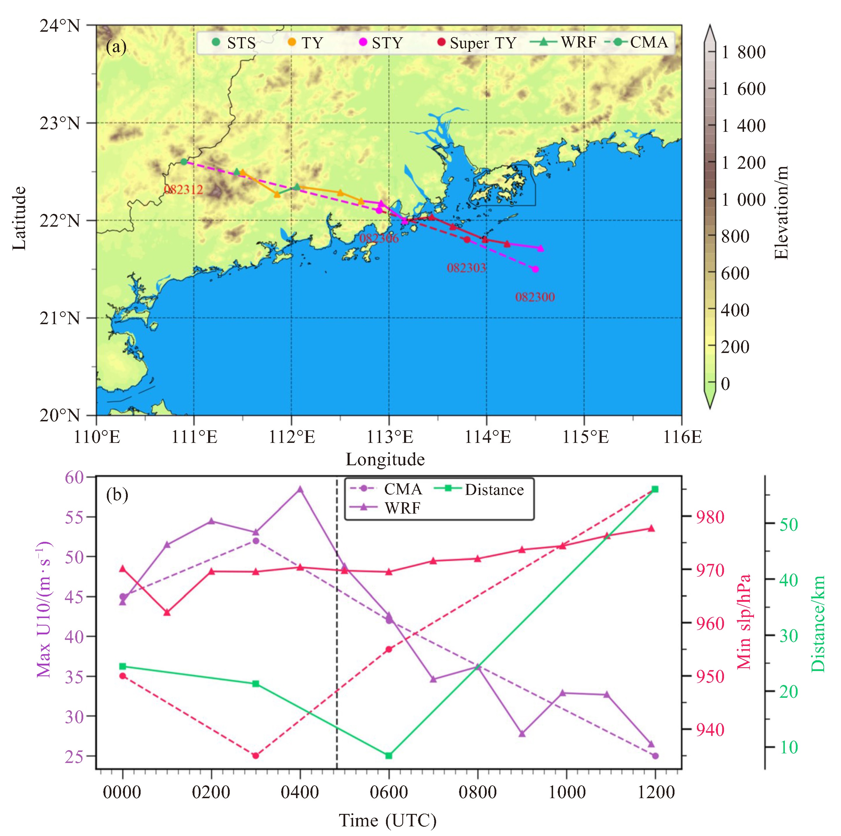
图 2 2017年8月23日模拟路径与CMA最佳路径数据集数据对比(a),近地面10 m最大风速和最小海平面气压对比及不同时刻空间误差(b)
a中所标时间为CMA最佳路径数据集所对应的时刻。b中WRF−LES数据采样间隔为1 h,黑色虚线代表登陆时刻(2017年8月23日4时50分UTC)。

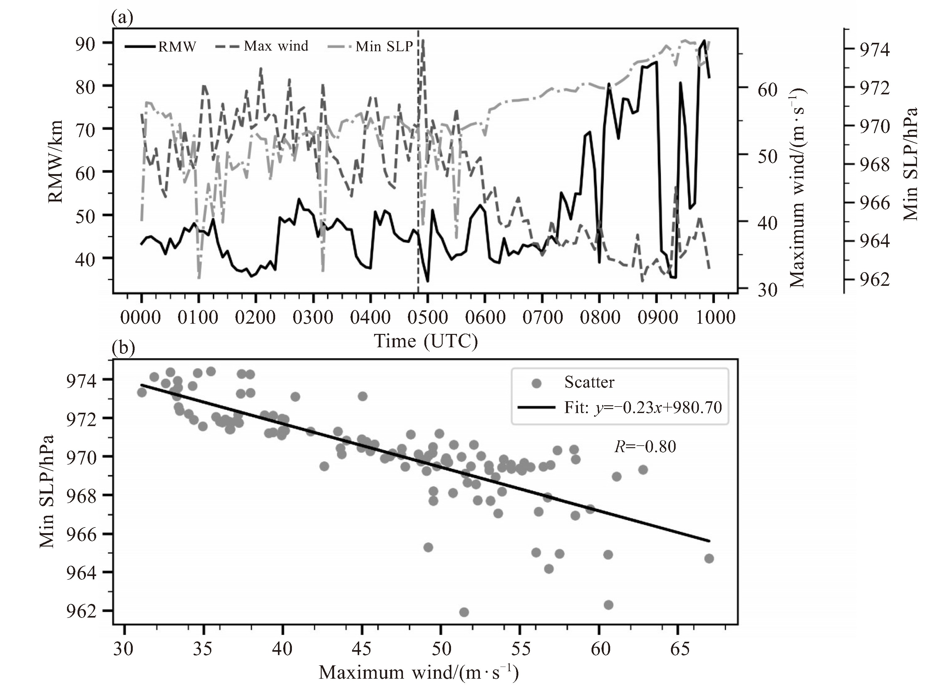
图 3 模拟的最大切向风半径、近地面10 m最大风速和最低海平面气压(a),最大风速与最低海平面气压之间的散点图及线性拟合结果(b)
a中黑色虚线代表登陆时刻(2017年8月23日4时50分UTC)。WRF−LES数据采样间隔为5 min。

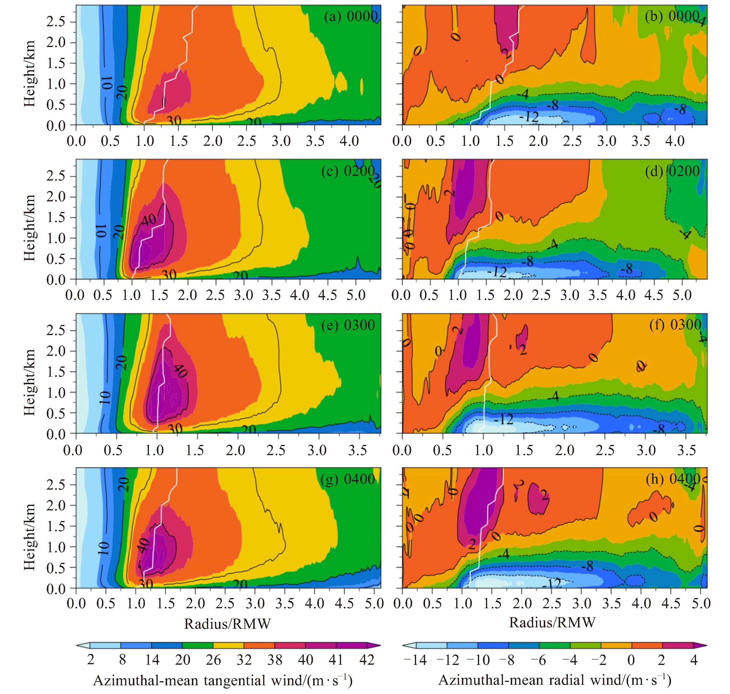
图 5 2017年8月23日00:00、02:00、03:00和04:00(UTC)四个时刻的方位平均切向风(a、c、e、g)和平均径向风(b、d、f、h)的空间分布
纵轴为垂直高度,横轴为经过近地面10 m最大切向风半径归一化后的半径。白色实线为各个高度上最大切向风出现位置归一化半径。

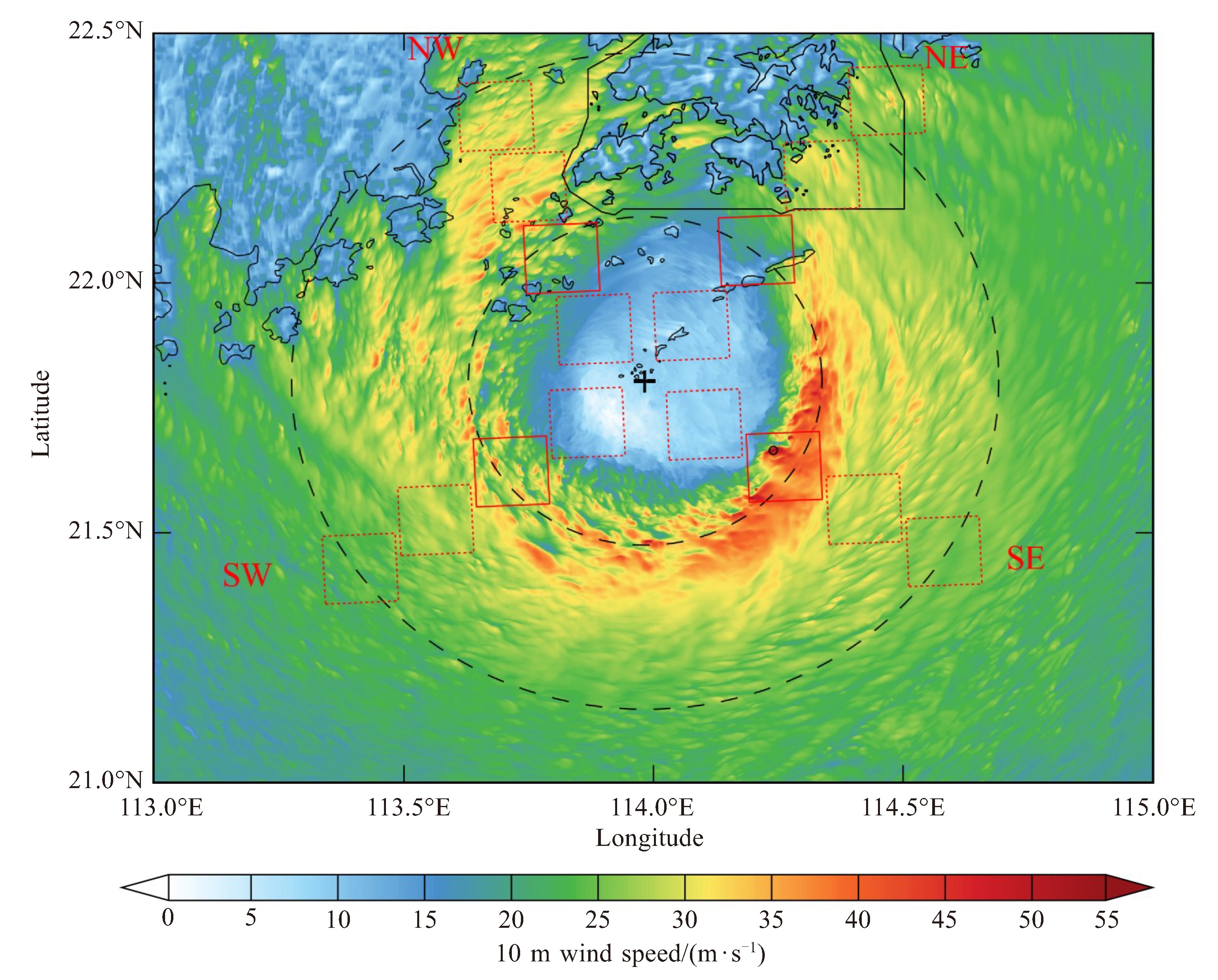
图 6 模拟2017年8月23日02:00(UTC)的10 m风场(风矢,单位:m·s-1)分布图
黑色“+”标志代表台风中心(113.98 °E,21.80 °N),黑色空心点代表最大风出现位置,红色方框代表所选择的距离台风中心不同距离的研究区域,黑色虚线圆圈分别代表 1.0 RMW和2.0 RMW所在位置。

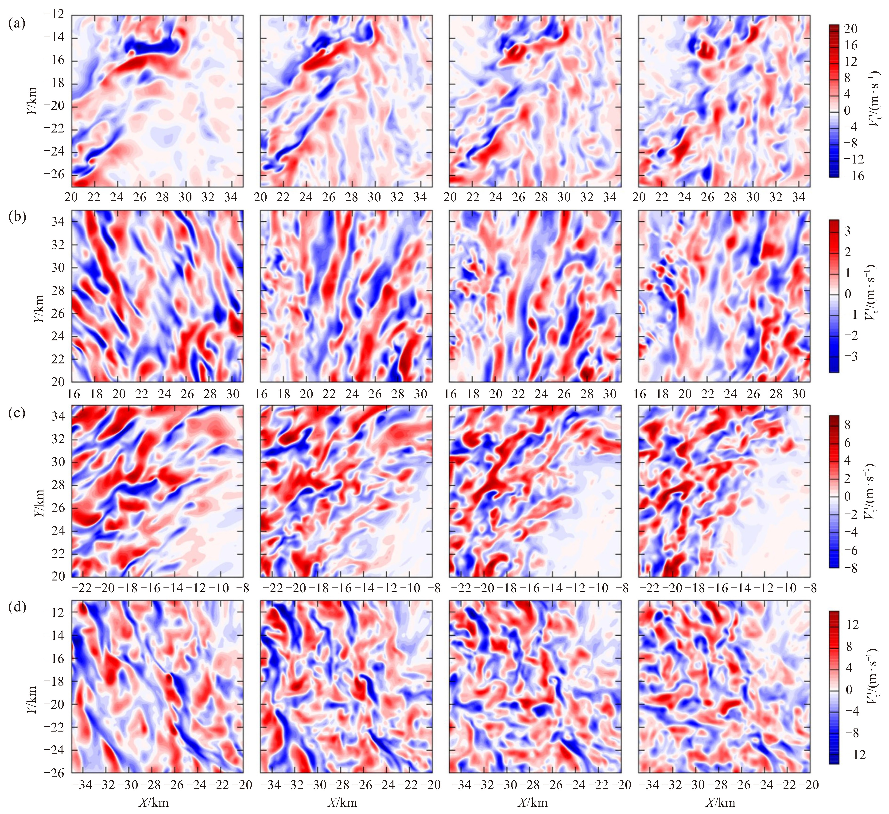
图 7 1.0 RMW位置最大风出现方位(a)、登陆前沿方位(b)、越过半岛后重新进入海洋方位(c)和离岸海洋方位(d)的切向扰动风速
四个方位如图 6红色实线方框所示,从左到右依次顺序为100 m、400 m、700 m和1 000 m高度的结果。

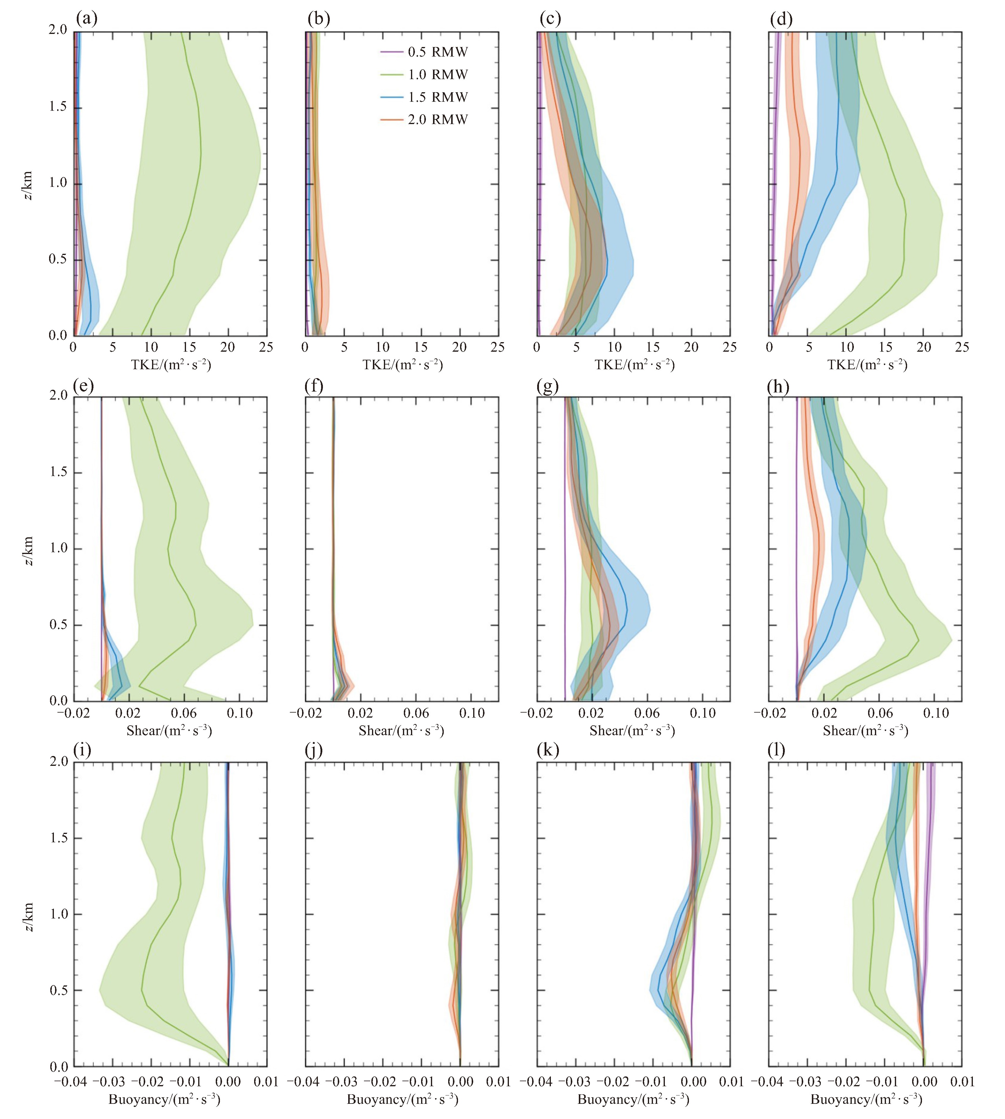
图 9 模拟的2 km以下沿最大风出现方位(a、e、i)、登陆前沿方位(b、f、j)、越过半岛后重新进入海洋方位(c、g、k)、离岸海洋方位(d、h、l)的平均湍流动能(单位:m2·s-2)、剪切生成项(单位:m2·s-3)和浮力项(单位:m2·s-3)廓线
阴影部分代表同一高度层上各变量的标准差。

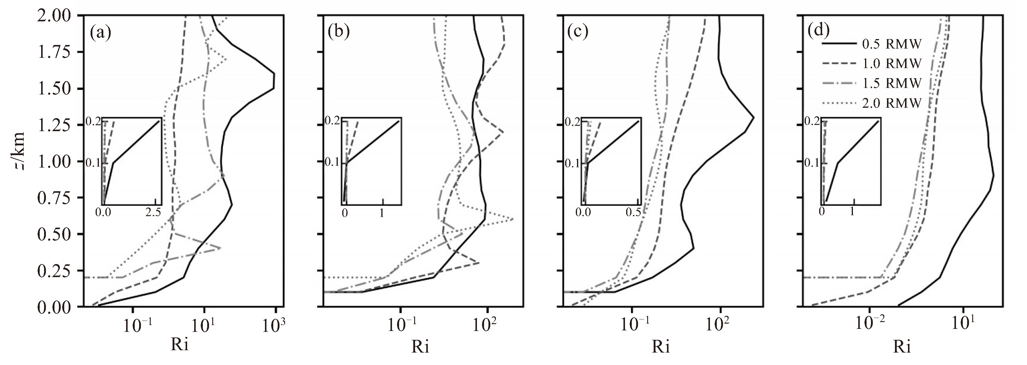
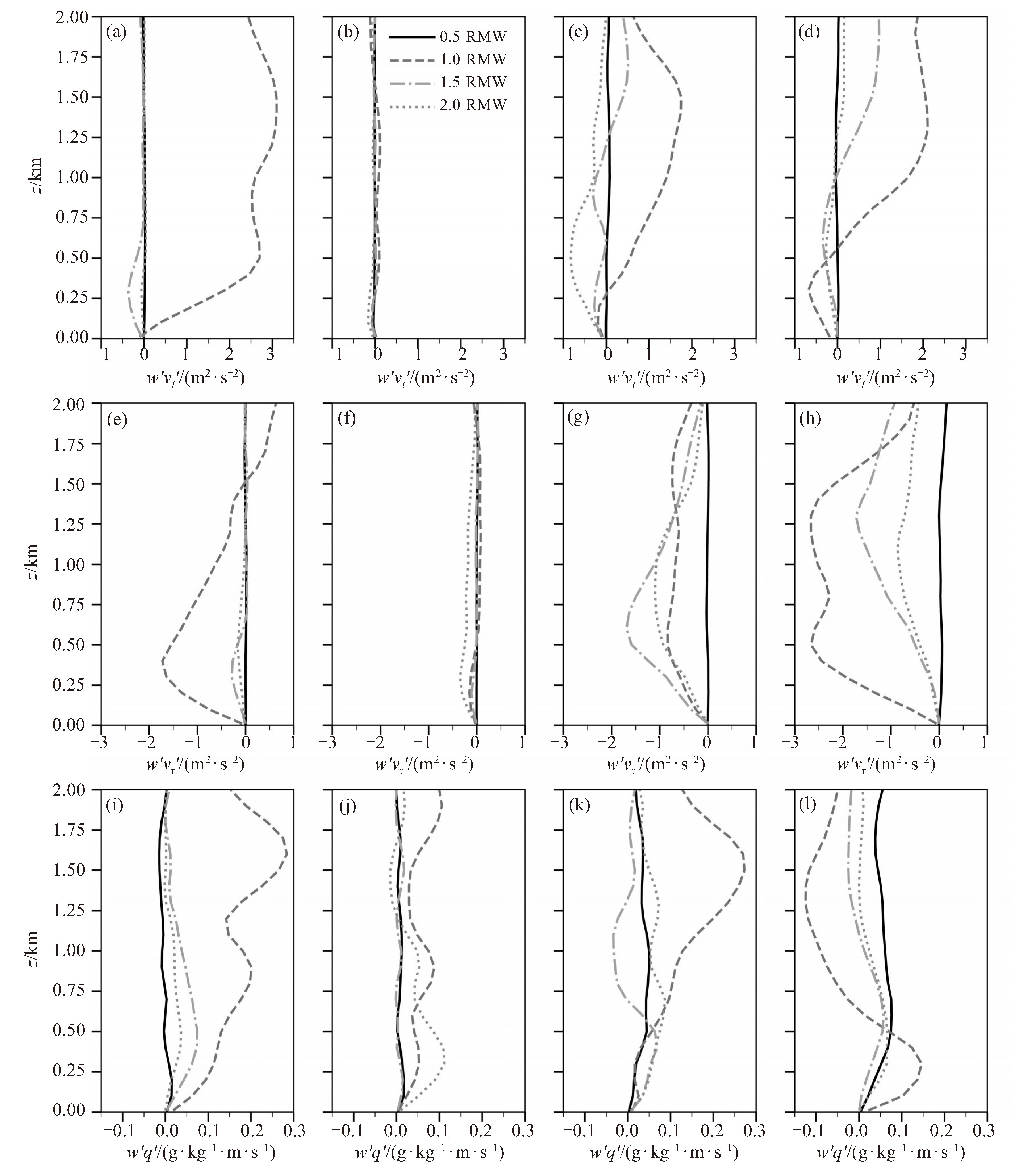
图 11 模拟的2 km以下的沿最大风出现方位(a、e、i)、登陆前沿方位(b、f、j)、越过半岛后重新进入海洋方位(c、g、k)、离岸海洋方位(d、h、l)的平均切向动量通量(单位:m2 ·s-2)、径向动量通量(单位:m2·s-2)和水汽通量(单位:g·kg-1·m·s-1)廓线

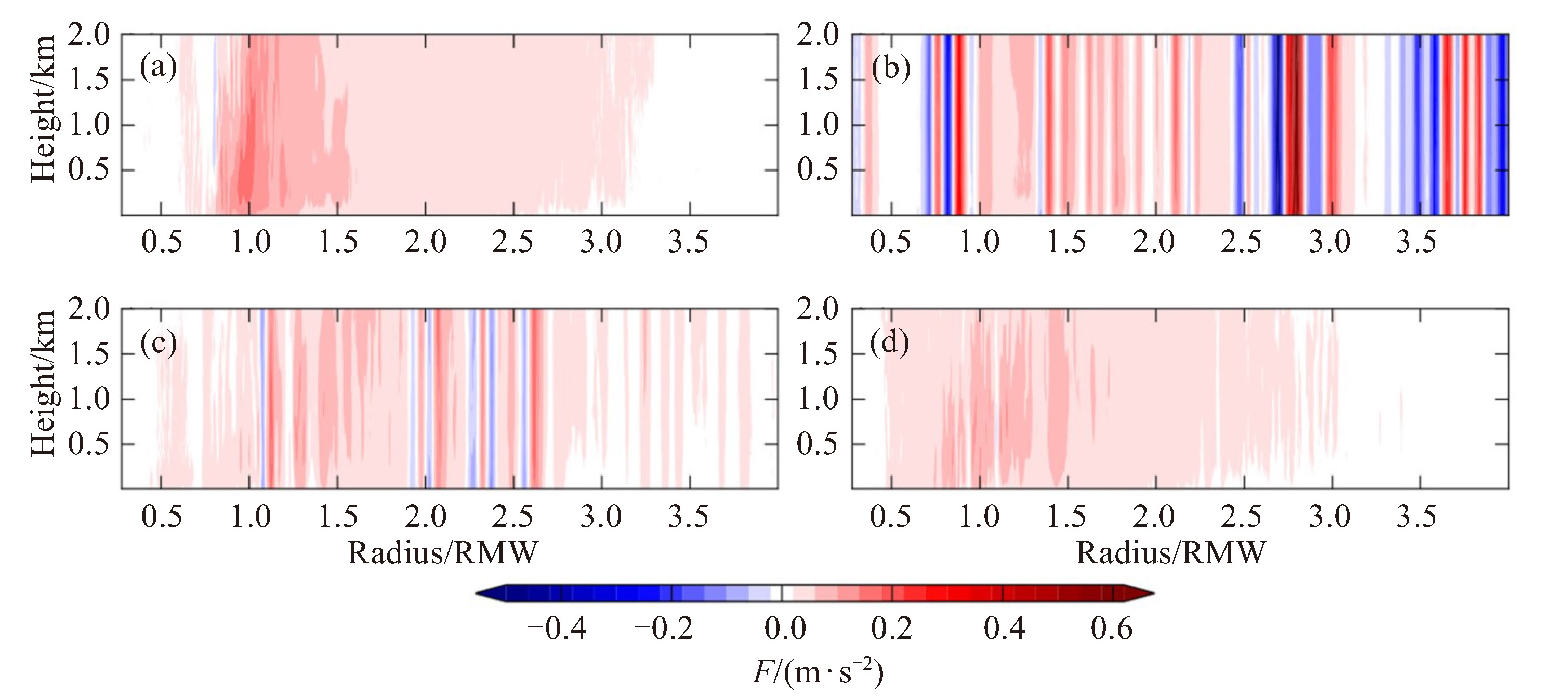
图 12 模拟2 km以下的沿最大风出现方位(a)、登陆前沿方位(b)、越过半岛后重新进入海洋方位(c)和离岸海洋方位(d)的不同位置区域平均梯度力F(单位:m·s-2)的径向—高度截面分布
-
[1] Knapp K R, Kruk M C, Levinson D H, et al. The international best track archive for climate stewardship (IBTrACS): unifying tropical cyclone data[J]. Bulletin of the American Meteorological Society, 2010, 91(3): 363-376. [2] 许映龙, 张玲, 高拴柱. 我国台风预报业务的现状及思考[J]. 气象, 2010, 36(7): 43-49. [3] 丑洁明, 董文杰, 徐洪, 等. 影响中国沿海区域的热带气旋及其经济损失评估[J]. 气象与环境科学, 2022, 45(3): 1-10. [4] Kieu C, Evans C, Jin Y, et al. Track dependence of tropical cyclone intensity forecast errors in the COAMPS-TC model[J]. Weather and Forecasting, 2021, 36(2): 469-485. [5] Rogers R F, Zhang J A. Airborne Doppler radar observations of tropical cyclone boundary layer kinematic structure and evolution during landfall[J]. Geophysical Research Letters, 2023, 50(23): e2023GL105548. [6] Cione J J, Kalina E A, Zhang J A, et al. Observations of air-sea interaction and intensity change in hurricanes[J]. Monthly Weather Review, 2013, 141(7): 2368-2382. [7] Kosiba K A, Wurman J. Finescale dual-Doppler analysis of hurricane boundary layer structures in hurricane frances (2004) at landfall[J]. Monthly Weather Review, 2014, 142(5): 1874-1891. [8] 张翰, 陈大可, 田娣, 等. 热带气旋海上观测技术的进展及展望[J]. 中国科学基金, 2024, 38(6): 961-968. [9] Liu Q Y, Wu L G, Qin N N, et al. Storm-scale and fine-scale boundary layer structures of tropical cyclones simulated with the WRF-LES framework[J]. Journal of Geophysical Research: Atmospheres, 2021, 126(21): e2021JD035511. [10] Talbot C, Bou-Zeid E, Smith J. Nested mesoscale large-eddy simulations with WRF: performance in real test cases[J]. Journal of Hydrometeorology, 2012, 13(5): 1421-1441. [11] Mirocha J, Kosović B, Kirkil G. Resolved turbulence characteristics in large-eddy simulations nested within mesoscale simulations using the weather research and forecasting model[J]. Monthly Weather Review, 2014, 142(2): 806-831. [12] Wang L Y, Tan Z M. Deep learning parameterization of the tropical cyclone boundary layer[J]. Journal of Advances in Modeling Earth Systems, 2023, 15: e2022MS003034. [13] Wurman J, Winslow J. Intense sub-kilometer-scale boundary layer rolls observed in hurricane fran[J]. Science, 1998, 280(5363): 555-557. [14] Kepert J, Wang Y Q. The dynamics of boundary layer jets within the tropical cyclone core. part Ⅱ: nonlinear enhancement[J]. Journal of the Atmospheric Sciences, 2001, 58(17): 2485-2501. [15] Rotunno R, Chen Y, Wang W, et al. Large-eddy simulation of an idealized tropical cyclone[J]. Bulletin of the American Meteorological Society, 2009, 90(12): 1783-1788. [16] Zhang J A, Nolan D S, Rogers R F, et al. Evaluating the impact of improvements in the boundary layer parameterization on hurricane intensity and structure forecasts in HWRF[J]. Monthly Weather Review, 2015, 143(8): 3136-3155. [17] Zhu P, Tyner B, Zhang J A, et al. Role of eyewall and rainband eddy forcing in tropical cyclone intensification[J]. Atmospheric Chemistry and Physics, 2019, 19(22): 14289-14310. [18] OGUEJIOFOR C N, RICHTER D H. Near-surface coherent structures in an intense tropical cyclone: conditional eddies and vertical momentum fluxes[A]. arXiv, 2025. [19] Green B W, Zhang F Q. Idealized large-eddy simulations of a tropical cyclone-like boundary layer[J]. Journal of the Atmospheric Sciences, 2015, 72(5): 1743-1764. [20] Gao Z, Wu L G, Zhou X Y. Fine-scale structures in the mid-level eyewall of super typhoon rammasun (2014) simulated with the WRF-LES framework[J]. Frontiers in Earth Science, 2022, 9: 814785. [21] Li X, Pu Z X, Gao Z Q. Effects of roll vortices on the evolution of hurricane Harvey during landfall[J]. Journal of the Atmospheric Sciences, 2021, 78(6): 1847-1867. [22] 谭晓伟. 边界层高度和动量粗糙度的不确定性对台风"天鸽("1713)模拟的影响[J]. 海洋气象学报, 2023, 43(1): 39-51. [23] 阎俊岳, 张秀芝, 陈乾金, 等. 热带气旋迅速加强标准的研究[J]. 气象, 1995(5): 9-13. [24] YU X, ZHENG T, WAN Q, et al. Causal analysis and numerical modeling of the inshore intensification of super typhoon "Hato"[J]. Journal of Tropical Meteorology, 2019, 25(03): 293-303. [25] Bae S Y, Hong S Y, Lim K S. Coupling WRF double-moment 6-class microphysics schemes to RRTMG radiation scheme in weather research forecasting model[J]. Advances in Meteorology, 2016, 2016: 5070154. [26] Iacono M J, Delamere J S, Mlawer E J, et al. Radiative forcing by long-lived greenhouse gases: calculations with the AER radiative transfer models[J]. Journal of Geophysical Research: Atmospheres, 2008, 113(D13): 2008JD009944. [27] Hong S Y, Noh Y, Dudhia J. A new vertical diffusion package with an explicit treatment of entrainment processes[J]. Monthly Weather Review, 2006, 134(9): 2318-2341. [28] Yang H D, Wu L G, Xie T. Comparisons of four methods for tropical cyclone center detection in a high-resolution simulation[J]. Journal of the Meteorological Society of Japan Ser Ⅱ, 2020, 98(2): 379-393. [29] Zhang J A, Marks F D, Montgomery M T, et al. An estimation of turbulent characteristics in the low-level region of intense hurricanes Allen (1980) and Hugo (1989)[J]. Monthly Weather Review, 2011, 139(5): 1447-1462. [30] Sroka S, Guimond S R. Organized kinetic energy backscatter in the hurricane boundary layer from radar measurements[J]. Journal of Fluid Mechanics, 2021, 924: A21. [31] Wu L G, Liu Q Y, Li Y B. Prevalence of tornado-scale vortices in the tropical cyclone eyewall[J]. Proceedings of the National Academy of Sciences of the United States of America, 2018, 115(33): 8307-8310. [32] Denis B, Côté J, Laprise R. Spectral decomposition of two-dimensional atmospheric fields on limited-area domains using the discrete cosine transform (DCT)[J]. Monthly Weather Review, 2002, 130(7): 1812-1829. [33] Zhu P. Simulation and parameterization of the turbulent transport in the hurricane boundary layer by large eddies[J]. Journal of Geophysical Research: Atmospheres, 2008, 113(D17): 2007JD009643. [34] Ying M, Zhang W, Yu H, et al. An overview of the China meteorological administration tropical cyclone database[J]. Journal of Atmospheric and Oceanic Technology, 2014, 31(2): 287-301. [35] Lu X Q, Yu H, Ying M, et al. Western north Pacific tropical cyclone database created by the China meteorological administration[J]. Advances in Atmospheric Sciences, 2021, 38(4): 690-699. [36] Kaplan J, DeMaria M. Large-scale characteristics of rapidly intensifying tropical cyclones in the north Atlantic Basin[J]. Weather and Forecasting, 2003, 18(6): 1093-1108. [37] Emanuel K. Tropical cyclones[J]. Annual Review of Earth and Planetary Sciences, 2003, 31: 75-104. [38] Smith R K, Montgomery M T, Van Sang N. Tropical cyclone spin-up revisited[J]. Quarterly Journal of the Royal Meteorological Society, 2009, 135(642): 1321-1335. [39] Xu H X, Duan Y H. Sensitivity of the tropical cyclone boundary layer to vertical diffusion in a turbulent kinetic energy-based boundary layer parameterization scheme at gray-zone resolution[J]. Journal of Geophysical Research: Atmospheres, 2022, 127(11): e2021JD035601. [40] Smith R K, Zhang J A, Montgomery M T. The dynamics of intensification in a Hurricane Weather Research and Forecasting simulation of Hurricane Earl (2010)[J]. Quarterly Journal of the Royal Meteorological Society, 2017, 143(702): 293-308. [41] Kepert J D. Time and space scales in the tropical cyclone boundary layer, and the location of the eyewall updraft[J]. Journal of the Atmospheric Sciences, 2017, 74(10): 3305-3323. [42] Emanuel K A. Sensitivity of tropical cyclones to surface exchange coefficients and a revised steady-state model incorporating eye dynamics [J]. Journal of the Atmospheric Sciences, 1995, 52(22): 3969-3976. [43] Kepert J. The dynamics of boundary layer jets within the tropical cyclone core. part Ⅰ: linear theory[J]. Journal of the Atmospheric Sciences, 2001, 58(17): 2469-2484. [44] Andersen T, Shepherd M. Inland tropical cyclones and the "brown ocean" concept[M]//Hurricanes and climate change: volume 3. Cham: Springer, 2017: 117-134. [45] Wang S H, Tang J. Analyzing coherent structures in the tropical cyclone boundary layer using large eddy simulations[J]. Tropical Cyclone Research and Review, 2024, 13(3): 230-238. [46] Ito J, Oizumi T, Niino H. Near-surface coherent structures explored by large eddy simulation of entire tropical cyclones[J]. Scientific Reports, 2017, 7: 3798. [47] Jing Y, Wang H, Zhu P, et al. The sensitivity of large eddy simulations to grid resolution in tropical cyclone high wind area applications[J]. Remote Sensing, 2023, 15(15): 3785. [48] Wu L G, Liu Q Y, Li Y B. Tornado-scale vortices in the tropical cyclone boundary layer: numerical simulation with the WRF-LES framework[J]. Atmospheric Chemistry and Physics, 2019, 19(4): 2477-2487. [49] Morrison I, Businger S, Marks F, et al. An observational case for the prevalence of roll vortices in the hurricane boundary layer[J]. Journal of the Atmospheric Sciences, 2005, 62(8): 2662-2673. [50] Li X, Pu Z X. Dynamic mechanisms associated with the structure and evolution of roll vortices and coherent turbulence in the hurricane boundary layer: a large eddy simulation during the landfall of hurricane Harvey[J]. Boundary-Layer Meteorology, 2023, 186(3): 615-636. [51] Lorsolo S, Zhang J A, Marks F Jr, et al. Estimation and mapping of hurricane turbulent energy using airborne Doppler measurements[J]. Monthly Weather Review, 2010, 138(9): 3656-3670. [52] Duan Z Q, Yao X H, Li Y P, et al. Investigation of turbulent momentum flux in the typhoon boundary layer[J]. Journal of Geophysical Research: Oceans, 2017, 122(3): 2259-2268. [53] Gao K, Ginis I. On the generation of roll vortices due to the inflection point instability of the hurricane boundary layer flow[J]. Journal of the Atmospheric Sciences, 2014, 71(11): 4292-4307. [54] Smith R K, Montgomery M T. Hurricane boundary-layer theory[J]. Quarterly Journal of the Royal Meteorological Society, 2010, 136(652): 1665-1670. [55] Emanuel K, DesAutels C, Holloway C, et al. Environmental control of tropical cyclone intensity[J]. Journal of the Atmospheric Sciences, 2004, 61(7): 843-858. [56] Madhulatha A, Dudhia J, Park R S, et al. Effect of single and double moment microphysics schemes and change in cloud condensation nuclei, latent heating rate structure associated with severe convective system over Korean Peninsula[J]. Atmosphere, 2023, 14(11): 1680. [57] Zhang J A, Drennan W M, Black P G, et al. Turbulence structure of the hurricane boundary layer between the outer rainbands[J]. Journal of the Atmospheric Sciences, 2009, 66(8): 2455-2467. -

 下载:
 点击查看大图
计量
- 文章访问数: 174
- HTML全文浏览量: 13
- PDF下载量: 41
- 被引次数: 0
 粤公网安备 4401069904700003号
