


Study of Downscaling from CMIP6 Global Climate Model by Using Terrain-Guided Multi-Scale Residual Dense Network
-
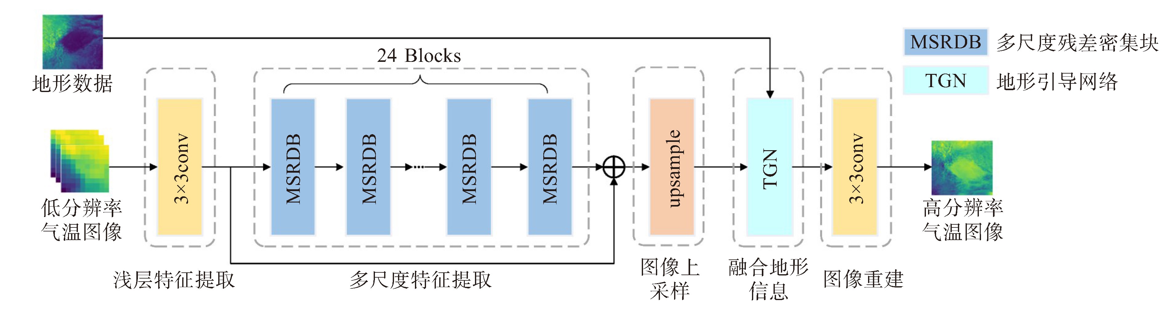
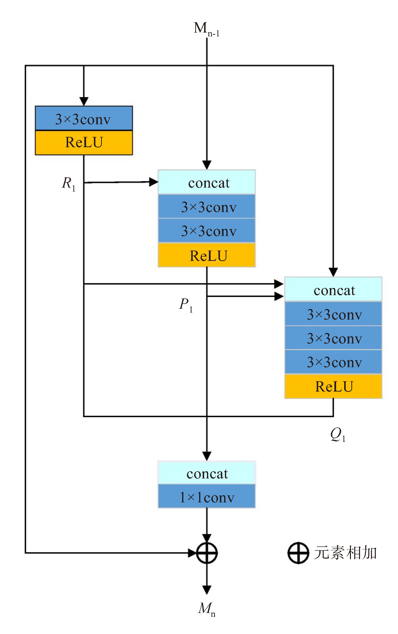
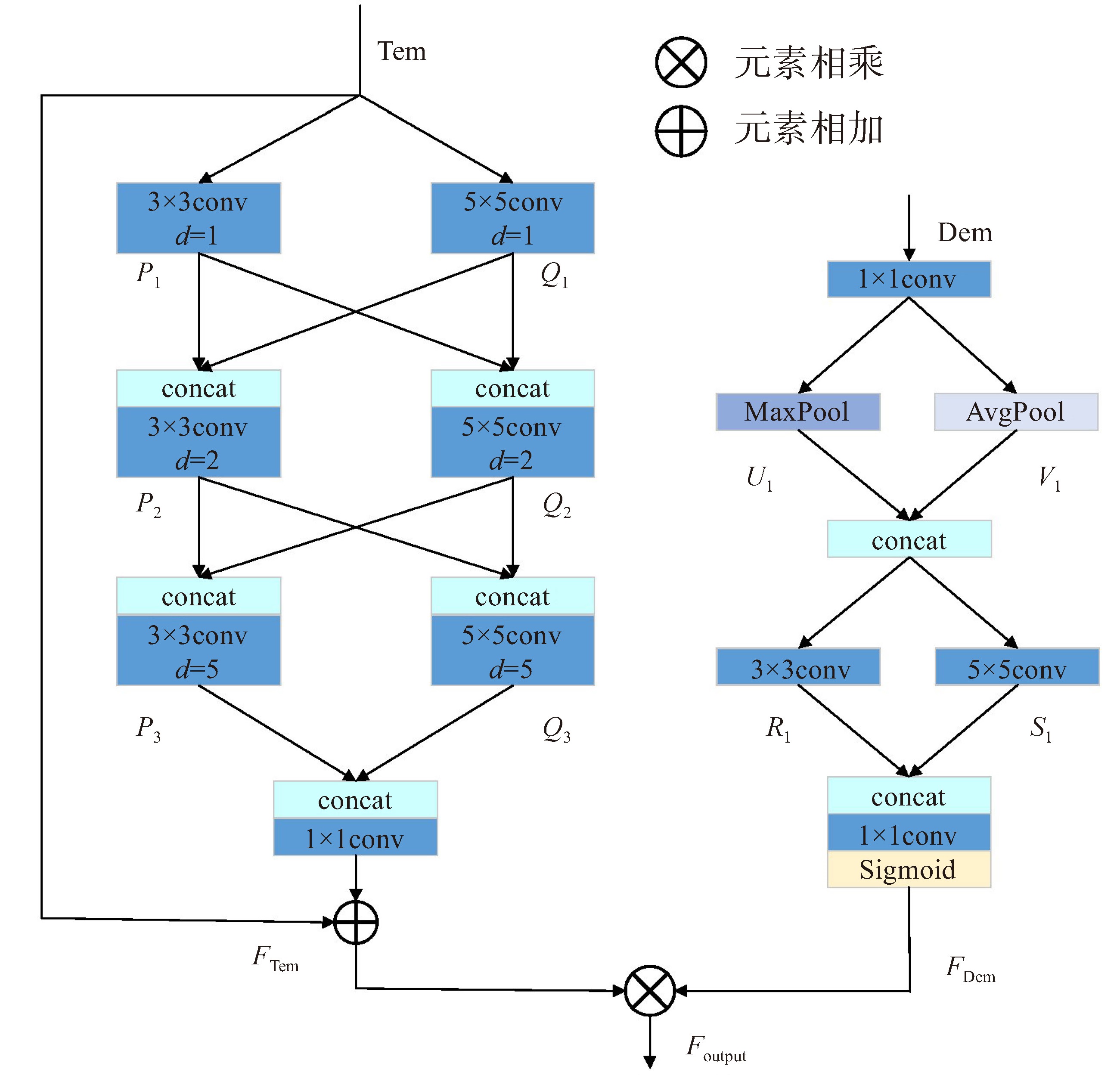
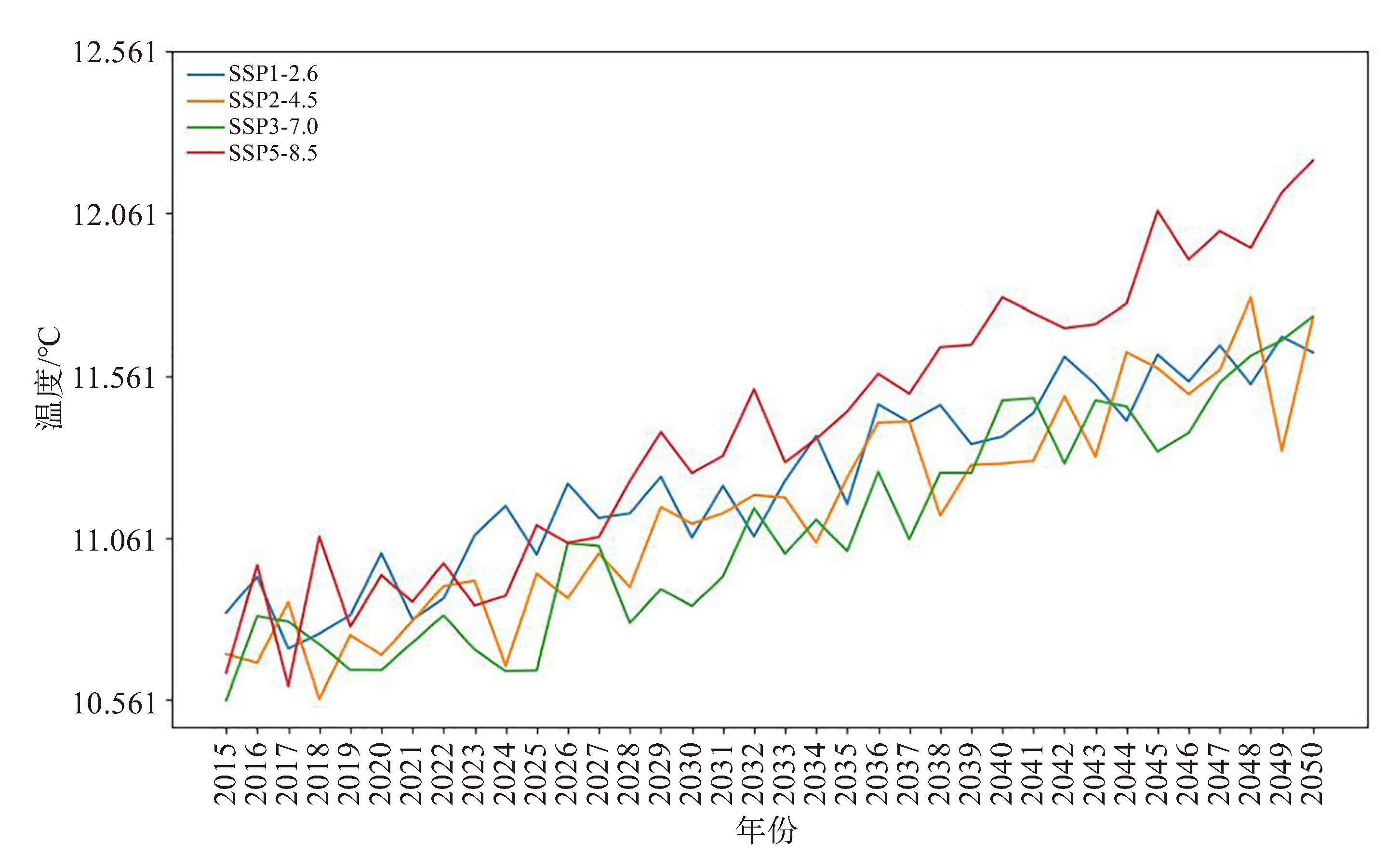
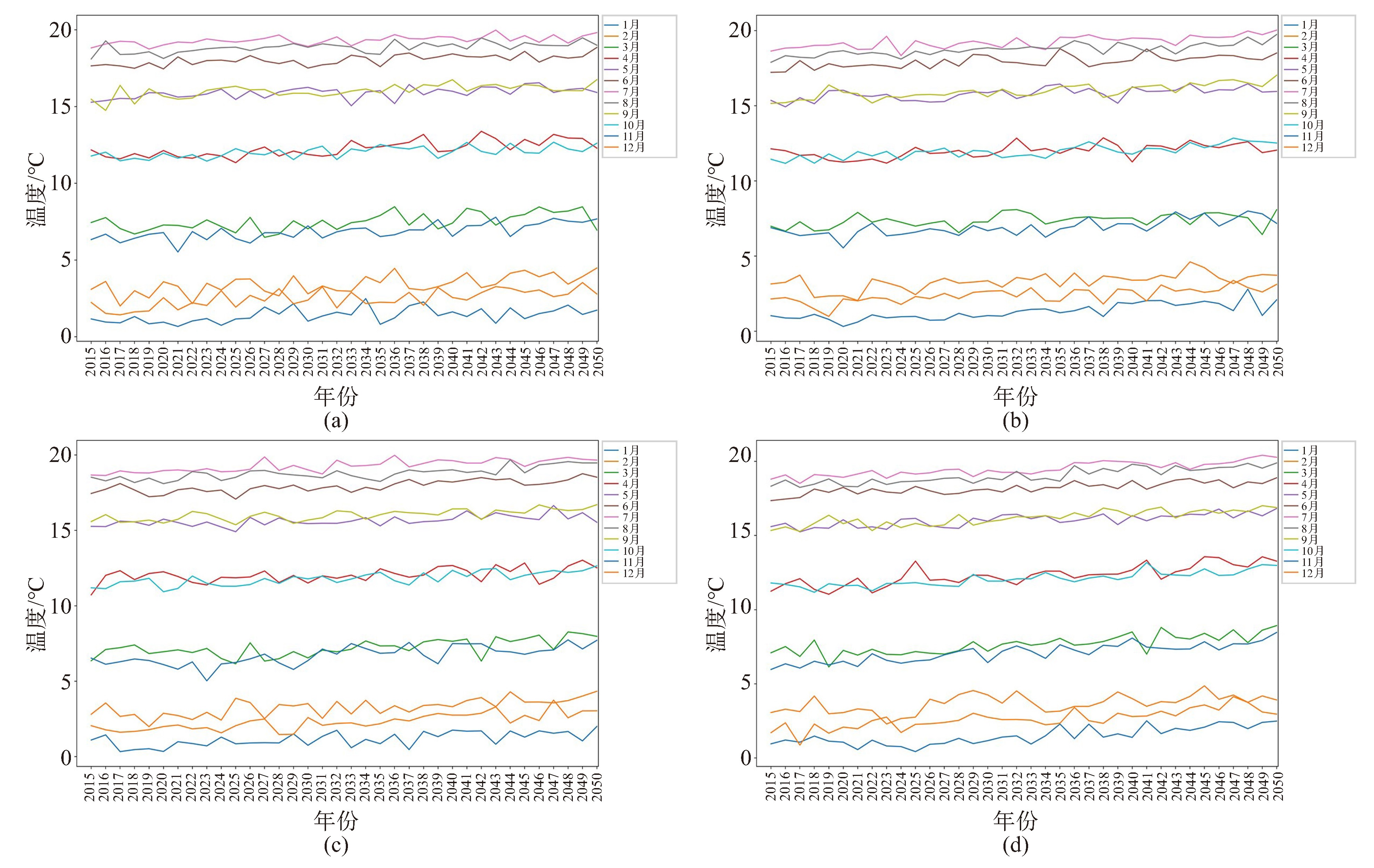
摘要: CMIP6全球气候模式是预测未来气候变化的重要工具之一,然而其输出数据的空间分辨率较为粗糙(通常大于1 °),难以直接应用于区域尺度气候变化研究。为此,本文提出一种地形引导的多尺度残差密集网络(Terrain-Guided Multi-Scale Residual Dense Network,TGMSRDN)降尺度模型,旨在提高应用于中国西南地区全球气候模式日平均气温数据的空间分辨率和精度。具体而言,该模型构建一种多尺度残差密集块,用于从粗分辨率气温数据中提取多尺度特征信息。此外,为充分利用地形信息,本文提出一种地形引导网络,该网络采用注意力机制有效聚合气温数据与地形信息,从而更精细地恢复了气温数据的空间细节。在中国西南地区进行的对比实验表明,TGMSRDN能够有效地将全球气候模式日平均气温空间分辨率由1 °提升到0.1 °,效果优于其它对比方法。最后,本文应用所提模型对研究区域2015—2050年在四种预估情景下(SSP1-2.6、SSP2-4.5、SSP3-7.0、SSP5-8.5)气温预估数据进行降尺度分析。结果显示,四种情景下研究区域年平均气温均呈上升趋势,特别是在SSP5-8.5情景下,至2050年研究区域的升温幅度将超过1.5 ℃。
-
关键词:
- CMIP6全球气候模式 /
- 气候变化 /
- 降尺度 /
- 气候变化预估
Abstract: CMIP6 global climate model (GCM) is one of the primary tools for predicting future climate change. However, their outputs usually have a coarse spatial resolution (typically ≥1 °), making them difficult to apply directly to regional-scale climate change studies. To address this issue, this study proposes a Terrain-Guided Multi-scale Residual Dense Network (TGMSRDN) downscaling model, aiming to improve the spatial resolution and accuracy of GCM daily mean temperature data for Southwest China. Specifically, the model constructs a Multi-scale Residual Dense Block (MSRDB) to extract of multi-scale feature information from the coarse-resolution temperature data. In addition, a Terrain-Guided Network (TGN) is designed to fully leverage topographic information. This network effectively aggregates temperature data with topographic information via an attention mechanism, thereby recovering finer spatial details in the temperature data. Comparative experiments conducted in Southwest China demonstrate that TGMSRDN can effectively improve the spatial resolution of the GCM daily mean temperature from 1 ° to 0.1 °, and performs better when compared with several advanced deep-learning-based super-resolution methods. Finally, the proposed model is applied to downscale the temperature projection data for the study area during 2015-2050 under four scenarios (SSP1-2.6, SSP2-4.5, SSP3-7.0, and SSP5-8.5). The results indicate that the annual mean temperature of the study area exhibits an increasing trend under all four scenarios. Notably, the temperature rise in the study area is projected to exceed 1.5 ℃ by 2050 under the SSP5-8.5 scenario.-
Key words:
- CMIP6 global climate model /
- climate change /
- downscaling /
- climate change projections
-

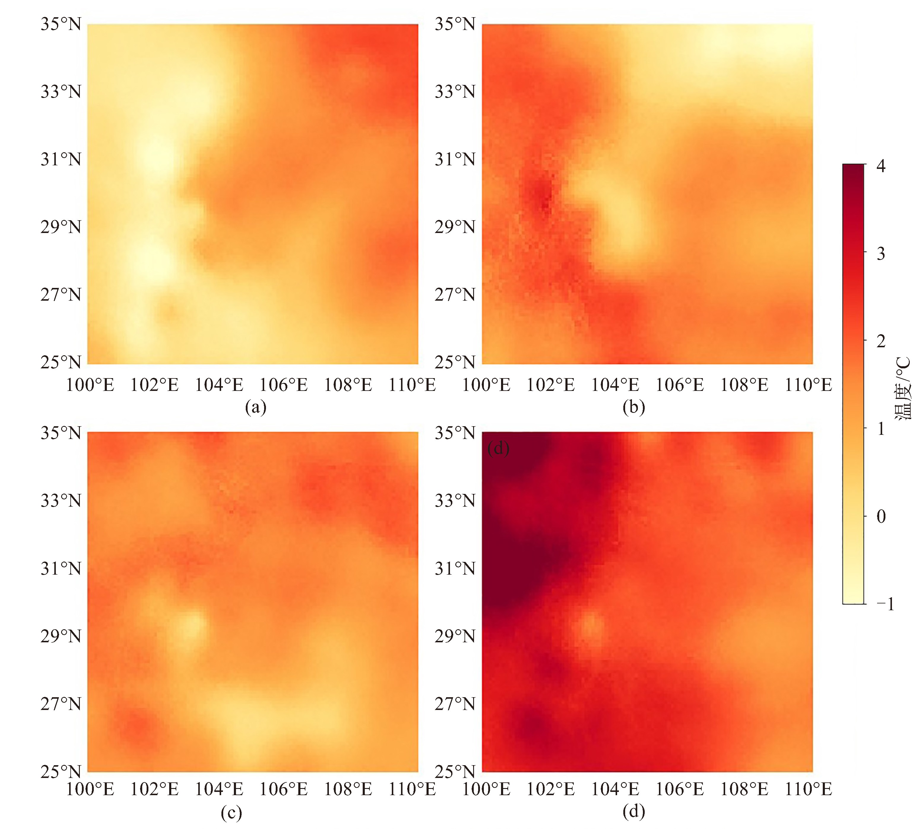
图 10 2050年相较于2015年同月的月平均温差空间分布
a.6月,SSP1-2.6;b.6月,SSP5-8.5;c.11月,SSP1-2.6;d.11月,SSP5-8.5。
表 1 14个CMIP6全球气候模式的基本信息
研究机构 模式名称 分辨率(/经向网格数×纬向网格数) AWI AWI-CM-1-1-MR 192×384 BCC BCC-CSM2-MR 160×320 CAMS CAMS-CSM1-0 160×320 NCAR CESM2 192×288 NCAR CESM2-WACCM 192×288 CMCC CMCC-CM2-SR5 192×288 CMCC CMCC-ESM2 192×288 EC-Earth-Consortium EC-Earth3 256×512 NOAA-GFDL GFDL-ESM4 180×288 INM INM-CM4-8 120×180 INM INM-CM5-0 120×180 MPI-M MPI-ESM1-2-HR 192×384 MRI MRI-ESM2-0 160×320 AS-RCEC TaiESM1 192×288  下载: 导出CSV
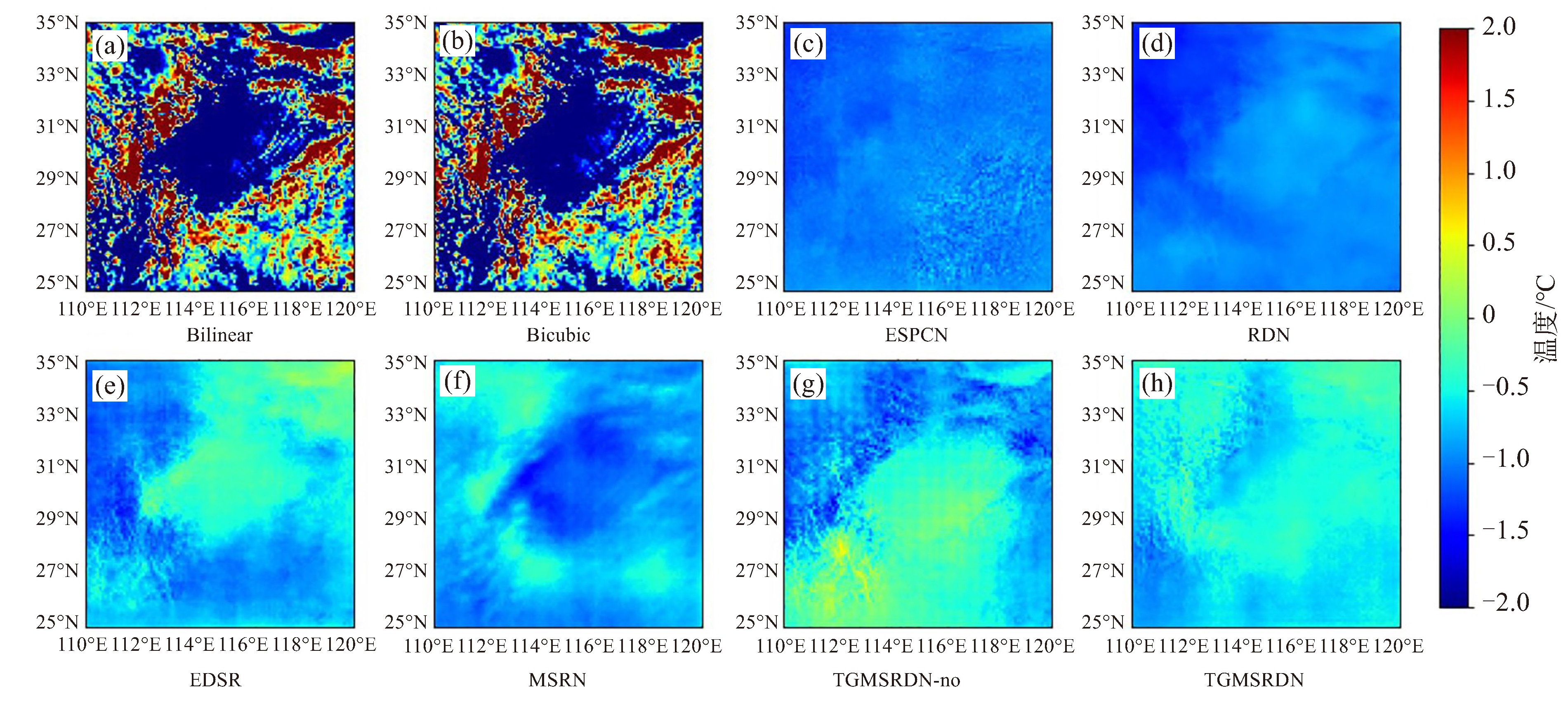
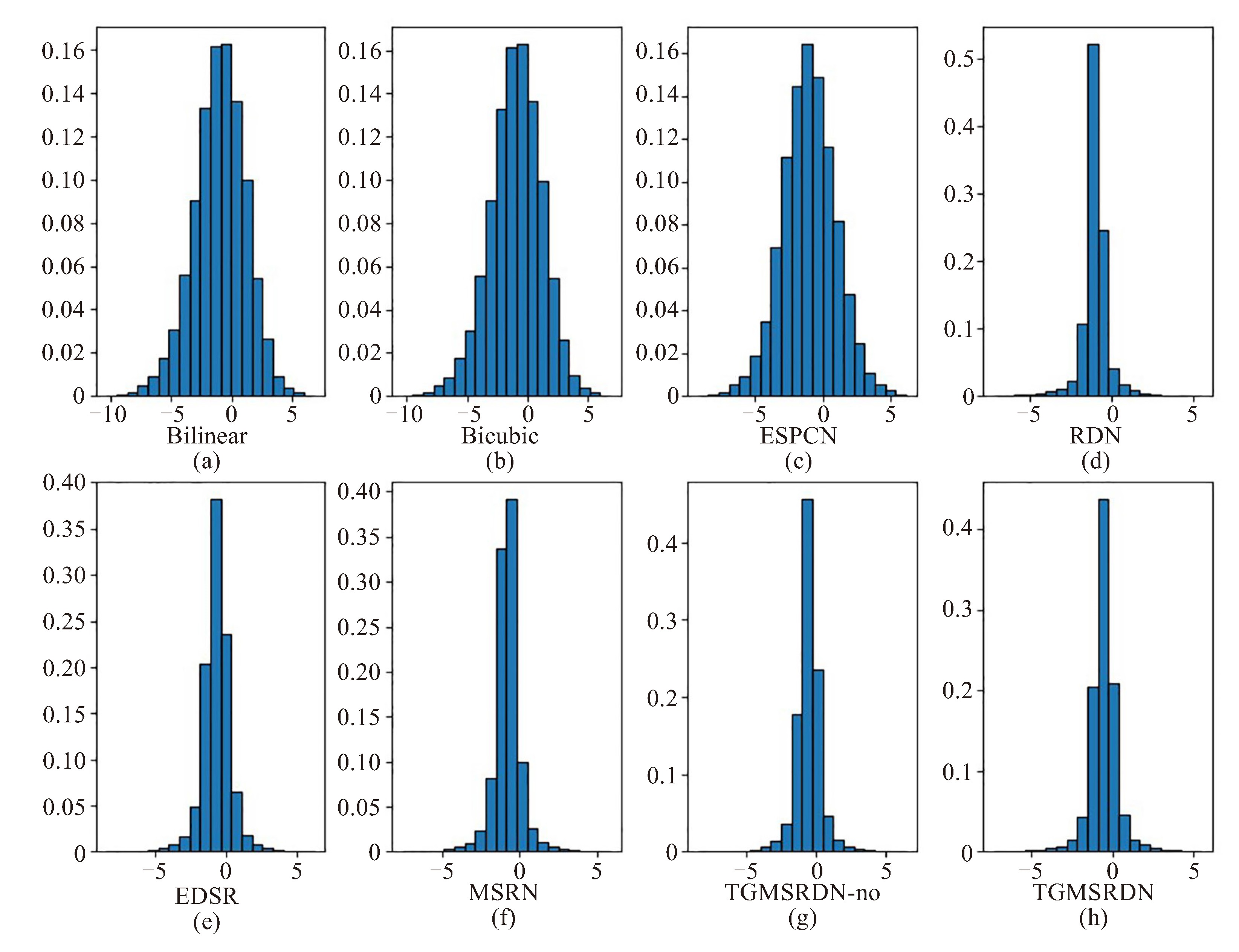
表 2 各方法日尺度降尺度效果定量评估结果(粗体表示最佳)
方法 平均 PSNR RMSE MSE MAE BIAS SSIM Bilinear 35.60 4.41 19.46 3.48 -0.99 0.05 Bicubic 35.66 4.38 19.23 3.46 -1.00 0.06 ESPCN 39.75 3.01 9.08 2.38 -1.01 0.792 RDN 45.13 1.68 2.85 1.32 -1.02 0.891 MSRN 44.62 1.75 3.07 1.33 -0.81 0.897 EDSR 43.49 1.94 3.77 1.48 -0.67 0.869 TGMSRDN-no 44.66 1.73 2.99 1.30 -0.59 0.882 TGMSRDN 45.41 1.62 2.65 1.21 -0.55 0.903
下载: 导出CSV
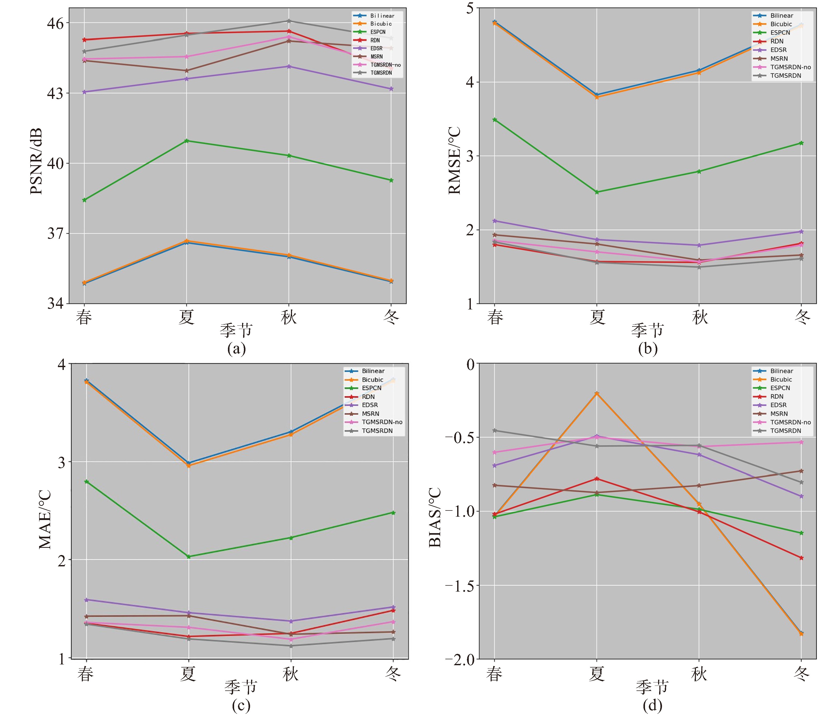
表 3 各方法季节尺度评价指标结果(粗体表示最佳,数值为“春/夏/秋/冬”)
方法 PSNR RMSE MAE BIAS Bilinear 34.86/36.60/36.00/34.94 4.81/3.82/4.15/4.77 3.82/2.98/3.29/3.83 -1.03/-0.20/-0.94/-1.82 Bicubic 34.90/36.68/36.07/34.98 4.79/3.79/4.12/4.75 3.80/2.95/3.27/3.81 -1.03/-0.20/-0.95/-1.82 ESPCN 38.43/40.96/40.33/39.27 3.49/2.50/2.79/3.17 2.79/2.02/2.22/2.47 -1.03/-0.88/-0.98/-1.14 RDN 45.27/45.53/45.63/44.05 1.79/1.56/1.55/1.81 1.34/1.21/1.24/1.47 -1.01/-0.77/-1.00/-1.31 EDSR 43.05/43.61/44.14/43.18 2.12/1.86/1.79/1.97 1.59/1.45/1.37/1.51 -0.69/-0.49/-0.61/-0.89 MSRN 44.38/43.96/45.22/44.92 1.93/1.80/1.58/1.65 1.42/1.42/1.23/1.26 -0.82/-0.87/-0.82/-0.72 TGMSRDN-no 44.45/44.55/45.39/44.23 1.85/1.70/1.56/1.79 1.35/1.30/1.18/1.36 -0.45 /-0.56/-0.55/-0.80 TGMSRDN 44.78/45.46/46.07/45.34 1.83/1.55/1.49/1.60 1.34/1.18/1.18/1.19 -0.60/-0.50/-0.56/-0.53
下载: 导出CSV
-
[1] CALVIN K, DASGUPTA D, KRINNER A, et al. IPCC, 2023: Climate Change 2023: Synthesis Report. Contribution of Working Groups Ⅰ, Ⅱ and Ⅲ to the Sixth Assessment Report of the Intergovernmental Panel on Climate Change[Core Writing Team, H. Lee and J. Romero (eds. )][R]. IPCC, Geneva, Switzerland, 2023. [2] ALLEN M, DUBE O P, SOLECKI W, et al. Special Report: Global Warming of 1.5 ℃[R]. Intergovernmental Panel on Climate Change (IPCC), 2018. [3] DOURY A, SOMOT S, GADAT S, et al. Regional climate model emulator based on deep learning: Concept and first evaluation of a novel hybrid downscaling approach[J]. Climate Dyn, 2023, 60(5-6): 1 751-1 779. [4] SHARIFI E, SAGHAFIAN B, STEINACKER R. Downscaling satellite precipitation estimates with multiple linear regression, artificial neural networks, and spline interpolation techniques[J]. J Geophys Res Atmos, 2019, 124(2): 789-805. [5] EBRAHIMY H, AGHIGHI H, AZADBAKHT M, et al. Downscaling MODIS land surface temperature product using an adaptive random forest regression method and Google Earth Engine for a 19-years spatiotemporal trend analysis over Iran[J]. IEEE J Sel Topics Appl Earth Observ Remote Sens, 2021, 14: 2 103-2 112. [6] TRIPATHI S, SRINIVAS V V, NANJUNDIAH R S. Downscaling of precipitation for climate change scenarios: A support vector machine approach[J]. J Hydrol, 2006, 330(3-4): 621-640 [7] CHENG Y, WANG W, REN Z P, et al. Multi-scale feature fusion and transformer network for urban green space segmentation from high-resolution remote sensing images[J]. Int J Appl Earth Ob Geoinf, 2023, 124: 103 514. [8] WANG W, CHENG Y, REN Z P, et al. A novel hybrid method for urban green space segmentation from high-resolution remote sensing images[J]. Remote Sens, 2023, 15(23): 5 472. [9] LIU M, FU B L, XIE S Y, et al. Comparison of multi-source satellite images for classifying marsh vegetation using DeepLabV3 Plus deep learning algorithm[J]. Ecol Indic, 2021, 125: 107 562. [10] ZHU X X, TUIA D, MOU L C, et al. Deep learning in remote sensing: A comprehensive review and list of resources[J]. IEEE Geosci Remote Sens Mag, 2017, 5(4): 8-36. [11] DENG Z P, SUN H, ZHOU S L, et al. Multi-scale object detection in remote sensing imagery with convolutional neural networks[J]. ISPRS J Photogramm Remote Sens, 2018, 145: 3-22. [12] LI J X, PAN Z F, LIU Q S, et al. Stacked U-shape network with channel-wise attention for salient object detection[J]. IEEE Trans Multimedia, 2020, 23: 1 397-1 409. [13] 匡秋明, 沈晨凯, 于廷照, 等. 多尺度残差金字塔网络模型三维气象要素降尺度研究[J]. 大气科学学报, 2022, 45(5): 660-673. [14] LI X, ZHOU Y Y, SHA J, et al. Using a two-step downscaling method to assess the impact of climate change on total nitrogen load in a small basin[J]. J Hydrol, 2024, 628: 130 510. [15] GU S W, ZHOU Y, ZHAO L, et al. A fast generative adversarial network combined with transformer for downscaling GRACE terrestrial water storage data in Southwestern China[J]. IEEE Trans Geosci Remote Sens, 2024, 62: 1-16. [16] VANDAL T, KODRA E, GANGULY S, et al. Deepsd: Generating high resolution climate change projections through single image super-resolution[C]//Proceedings of the 23rd acm sigkdd international conference on knowledge discovery and data mining. 2017, 1 663-1 672. [17] DONG C, LOY C C, HE K M, et al. Image super-resolution using deep convolutional networks[J]. IEEE Trans Pattern Analysis Machine Intelligence, 2015, 38(2): 295-307. [18] LIU Y, GANGULY A R, DY J. Climate downscaling using YNet: A deep convolutional network with skip connections and fusion[C]// Proceedings of the 26th ACM SIGKDD International Conference on Knowledge Discovery & Data Mining. 2020, 3 145-3 153. [19] TEBALDI C, KNUTTI R. The use of the multi-model ensemble in probabilistic climate projections[J]. Philos Trans Royal Soc A: Math, Phys Eng Sci, 2007, 365(1 857): 2 053-2 075. [20] DESER C, LEHNER F, RODGERS K B, et al. Insights from Earth system model initial-condition large ensembles and future prospects[J]. Nat Clim Change, 2020, 10(4): 277-286. [21] LI P, SHI C, LI Z H, et al. Evaluation of ASTER GDEM using GPS benchmarks and SRTM in China[J]. Int J Remote Sens, 2013, 34(5): 1 744-1 771. [22] HE J, YANG K, TANG W J, et al. The first high-resolution meteorological forcing dataset for land process studies over China[J]. Sci Data, 2020, 7: 2 524, [23] YANG K, HE J, TANG W J, et al. On downward shortwave and longwave radiations over high altitude regions: Observation and modeling in the Tibetan Plateau[J]. Agric Forest Meteor, 2010, 150: 38-46. [24] YANG K, HE J, TANG W J, et al. China meteorological forcing dataset (1979-2018)[Z]. A Big Earth Data Platform for Three Poles, 2019. [25] HE K M, ZHANG X Y, REN S Q, et al. Deep residual learning for image recognition[C]//Proceedings of the IEEE conference on computer vision and pattern recognition. 2016, 770-778. [26] ODENA A, DUMOULIN V, OLAH C. Deconvolution and checkerboard artifacts[J]. Distill, 2016, 1(10): e3. [27] PING B, SU F Z, HAN X X, et al. Applications of deep learning-based super-resolution for sea surface temperature reconstruction[J]. IEEE J Sel Topics Appl Earth Observ Remote Sens, 2020, 14: 887-896. [28] SZEGEDY C, VANHOUCKE V, IOFFE S, et al. Rethinking the inception architecture for computer vision[C]//Proceedings of the IEEE conference on computer vision and pattern recognition. 2016, 2 818-2 826. [29] HUANG G, LIU Z, VAN DER MAATEN L, et al. Densely connected convolutional networks[C]//Proceedings of the IEEE conference on computer vision and pattern recognition. 2017, 4700-4708. [30] 邓酩, 柳庆龙, 侯立宪. 多尺度残差生成对抗网络的图像超分辨率重建[J]. 科学技术与工程, 2023, 23(31): 13 472-13 481. [31] CHEN L C, PAPANDREOU G, KOKKINOS I, et al. Deeplab: Semantic image segmentation with deep convolutional nets, atrous convolution, and fully connected crfs[J]. IEEE Trans Pattern Anal Mach Intell, 2017, 40(4): 834-848. [32] 李众, 王雅婧, 马巧梅. 基于空洞卷积的医学图像超分辨率重建算法[J]. 计算机应用, 2023, 43(9): 2 940-2 947. [33] WOO S, PARK J, LEE J Y, et al. Cbam: Convolutional block attention module[C]//Proceedings of the European conference on computer vision (ECCV). 2018, 3-19. [34] SHI W Z, CABALLERO J, HUSZÁR F, et al. Real-time single image and video super-resolution using an efficient sub-pixel convolutional neural network[C]//Proceedings of the IEEE conference on computer vision and pattern recognition. 2016, 1 874-1 883. [35] LIM B, SON S, KIM H, et al. Enhanced deep residual networks for single image super-resolution[C]//Proceedings of the IEEE conference on computer vision and pattern recognition workshops. 2017, 136-144. [36] LEDIG C, THEIS L, HUSZÁR F, et al. Photo-realistic single image super-resolution using a generative adversarial network[C]// Proceedings of the IEEE conference on computer vision and pattern recognition. 2017, 4 681-4 690. [37] ZHANG Y L, TIAN Y P, KONG Y, et al. Residual dense network for image super-resolution[C]//Proceedings of the IEEE conference on computer vision and pattern recognition. 2018, 2 472-2 481. [38] LI J C, FANG F M, MEI K F, et al. Multi-scale residual network for image super-resolution[C]//Proceedings of the European conference on computer vision (ECCV). 2018, 517-532. -

 点击查看大图
图(10) / 表(3)
计量
- 文章访问数: 4
- HTML全文浏览量: 1
- PDF下载量: 0
- 被引次数: 0
 粤公网安备 4401069904700003号