


Analysis of Remote Precipitation Caused by Typhoon Khanun (2017)
-
摘要: 台风远距离暴雨(TRP)是极端降水事件的重要成因,但业务预报对其量级和落区的系统性低估亟需进行深入的机制研究。以2017年台风“卡努”(登陆广东)在浙江引发的TRP为例,基于地面观测、雷达资料及NCEP CFSR再分析数据(0.5 °×0.5 °),揭示了暴雨的三维动力-热力耦合机制。结果表明:(1) 台风外围环流与低空急流协同构建水汽通道,暖平流显著增强暴雨区大气不稳定能量;(2) 低层台风倒槽北伸至浙江后,在涡度垂直输送(水平辐合辐散与扭曲项主导)作用下演变为切断低压,成为暴雨的直接触发系统;(3) 500 hPa副高边缘突发短波槽,其与低层切断低压的垂直耦合进一步强化上升运动。涡度收支分析表明,近地层涡度通过垂直运动向中高层(850~500 hPa)输送,形成“低层辐合-涡度增长-上升运动加强”的正反馈循环,最终导致极端降水。研究提出,TRP预报需重点关注低层暖平流强度、涡度垂直输送效率及高低空系统配置的协同作用,为改进业务预报模型提供理论依据。Abstract: TRP (Tropical cyclone Remote Precipitation) often produces extreme precipitation events, the actual magnitude of which is larger than forecasted. Therefore, it is necessary to carry out research to improve the forecast accuracy of such pecipitation. This paper analyzed a TRP event in Zhejiang caused by the NO.20 typhoon "Khanun" (which made landfall in Guangdong Province) in 2017. The evolution and characteristics of the precipitation system were analyzed using ground observation and radar data, while the specific causes were investigated using NCEP CFSR reanalysis data (horizontal resolution 0.5 °×0.5 °). The results show that the rainstorm process had the following characteristics. (1) Under the guidance of the typhoon peripheral circulation, there were obvious water vapor channels in the lower layer to transport water vapor to the rainstorm area, accompanied by strong warm advection; (2) The tip of the low-level typhoon trough extended to Zhejiang and developed into a cut-off depression; (3) The rainstorm area was originally controlled by the subtropical high at 500 hPa, and a short-wave trough developed at the edge of the subtropical high during the precipitation process, accompanied by strong upward motion. Vorticity budget analysis showed that the initial disturbance for the development of the cut-off low was mainly provided by the horizontal convergence divergence term and the distortion term in the surface layer. Vorticity was then transmitted upward from the near-surface layer to 850 - 500 hPa, resulting in the development of depression in the low-level layer and the emergence of short-wave trough in the middle layer, while strengthening the upward movement and surface cyclone. The key mechanism for the strong precipitation was the transformation of the typhoon trough into a strong cut-off low due to intense warm advection and vertical vorticity transport at low level. For forecasting, it is crucial to monitor the intensity of warm advection at low level and the coupling of vorticity and vertical movement at low level.
-

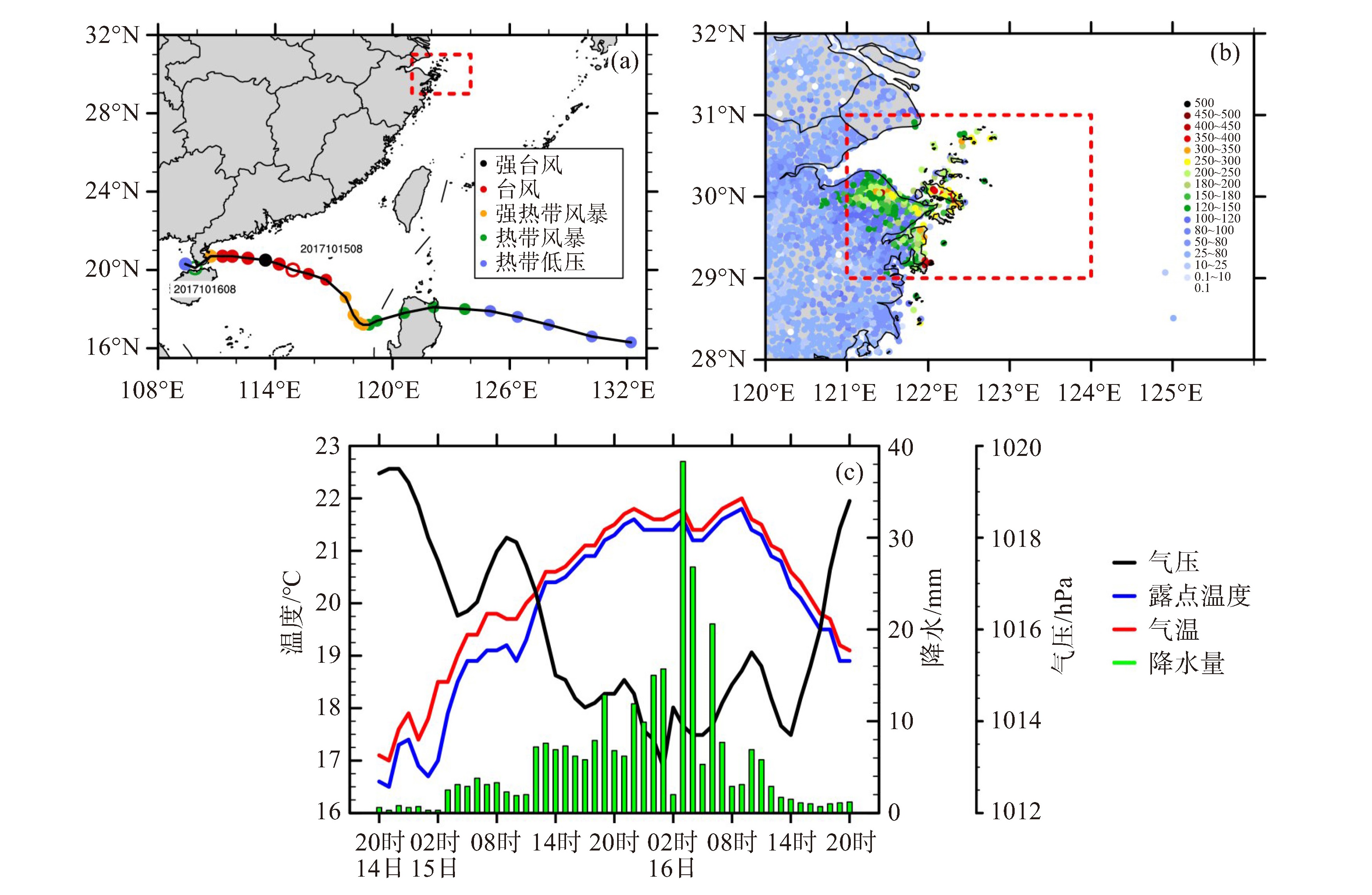
图 1 a. 台风“卡努”的移动路径(黑色实线)及强度(彩色圆点),其中空心圆点标注了远距离降水关键时段起止时刻台风所处的位置;b. 2017年10月14日20时—16日20时自动站观测累计雨量(彩色圆点,单位:mm),红色方框表示远距离降水区域;c. 普陀国家基本气象站海平面气压(黑色实线,单位:hPa)、露点温度(蓝色实线,单位:℃)、气温(红色实线,单位:℃)和降水(绿色柱状图,单位:mm)等天气要素的时间演变图

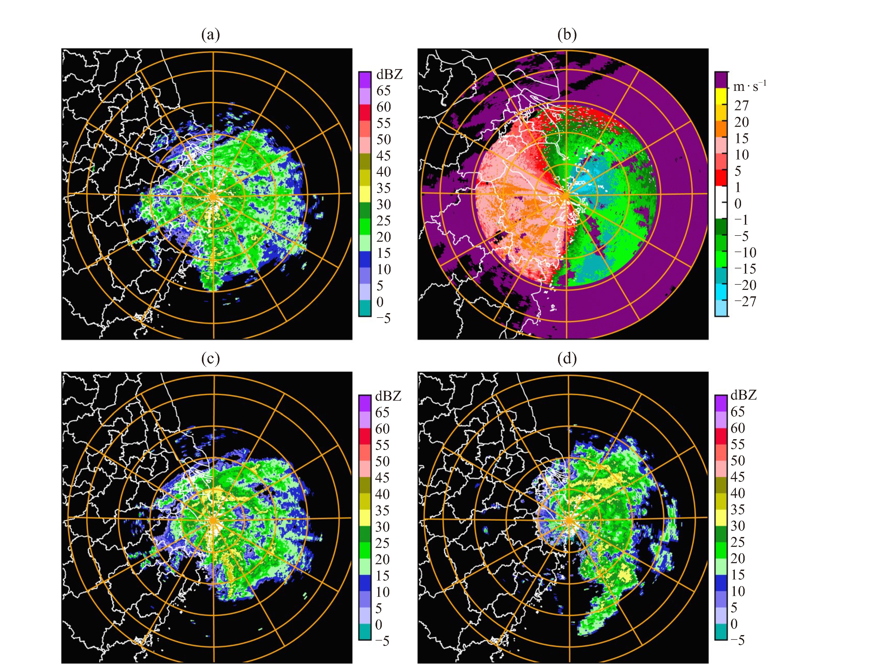
图 2 2017年10月15—16日舟山雷达0.5 °仰角反射率因子(单位:dBZ,a. 15日15:58,c. 15日20:59,d. 16日02:58)和0.5 °仰角径向速度产品(单位:m·s-1,b. 15日15:58)

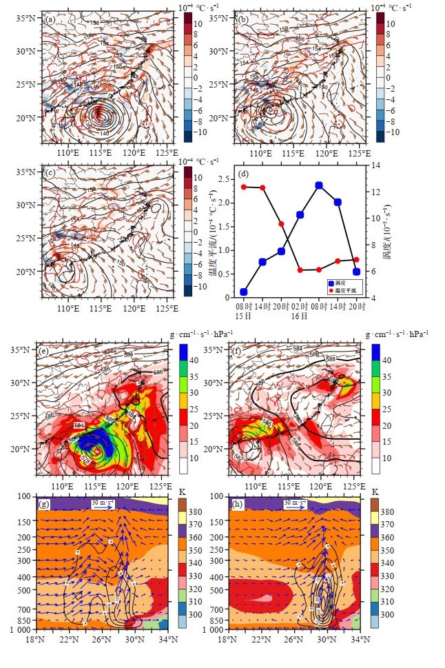
图 3 2017年10月15日08时(a)、15日20时(b)和16日08时(c)850 hPa高度场(黑色实线,单位:dagpm,下同)、温度场(红色实线,单位:℃,下同)、风场(棕色风羽,单位:m·s-1,下同)和温度平流(填色,单位:10-4 ℃·s-1,下同),15日08时—16日20时远距离降水区域平均的850 hPa温度平流(红色圆点)和涡度(蓝色方块,单位:10-5 s-1)随时间变化曲线(d),15日08时(e)和16日08时(f)500 hPa高度场、温度场、风场和850 hPa水汽通量(填色,单位:g·cm-1·s-1·hPa-1),15日08时假相当位温(填色,单位:K,下同)、垂直速度(黑色实线,单位:10-1 hPa·s-1,下同)、风矢量(垂直速度放大10倍)沿122 °E剖面分布(g),16日02时假相当位温、垂直速度、风矢量(垂直速度放大10倍)沿123 °E剖面分布(h)

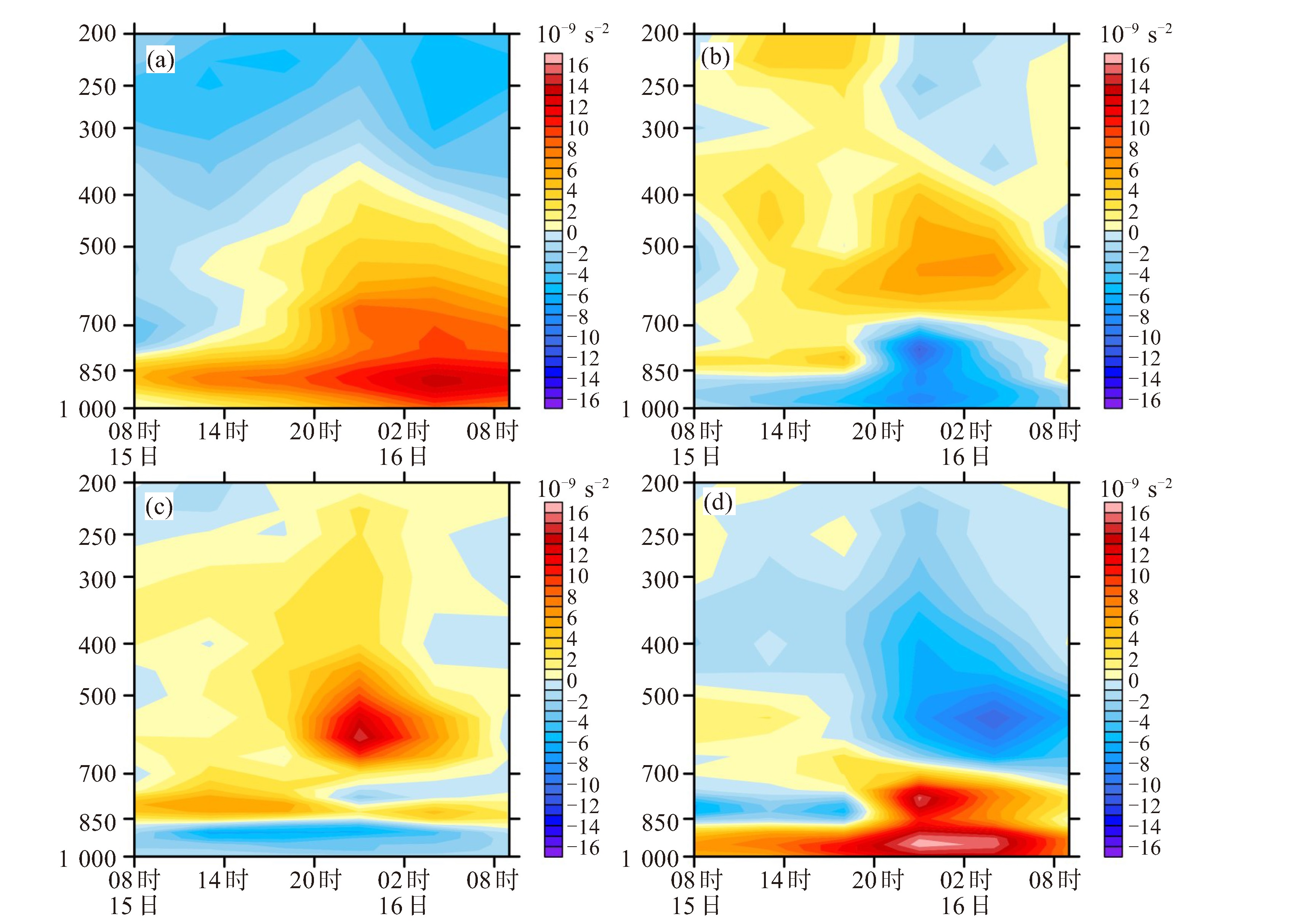
图 4 2017年10月15日08时—16日08时降水区(121~124 °E,29~31 °N)区域平均的涡度(a)随时间和高度的变化(单位:10-5 s-1),涡度平流项A (b)、垂直输送项B (c)、水平辐合辐散项C (d)垂直分布随时间的变化(单位:10-9 s-2)
-
[1] 陈联寿, 孟智勇, 丛春华. 台风暴雨落区研究综述[J]. 海洋气象学报, 2017, 37(4): 1-7. [2] 丛春华, 陈联寿, 雷小途, 等. 台风远距离暴雨的研究进展[J]. 热带气象学报, 2011, 27(1): 264-270. [3] 侯建忠, 王川, 鲁渊平, 等. 台风活动与陕西极端暴雨的相关特征分析[J]. 热带气象学报, 2006, 22(2): 203-208. [4] 张弘, 梁生俊, 侯建忠. 西安市两次突发暴雨成因分析[J]. 气象, 2006, 32(5): 80-86. [5] 丁治英, 陈久康. 不同雨强台风的诊断对比与数值试验研究[J]. 南京气象学院学报, 1995, 18(2): 234-241. [6] 周军, 陈瑞芬, 李文源. 登陆台风远距离暴雨的观测研究和预报[J]. 南京气象学院学报, 1995, 18(3): 376-382. [7] 朱洪岩, 陈联寿, 徐祥德. 中低纬度环流系统的相互作用及其暴雨特征的模拟研究[J]. 大气科学, 2000, 24(5): 669-675. [8] 孙建华, 齐琳琳, 赵思雄. "9608"号台风登陆北上引发北方特大暴雨的中尺度对流系统研究[J]. 气象学报, 2006, 64(1): 57-71. [9] 周国兵, 沈桐立, 韩余. 台风对西南低涡影响的数值模拟与诊断个例分析[J]. 气象科学, 2006, 26(6): 620-626. [10] 张少林, 龚佃利, 陈晓红, 等. 热带气旋远距离暴雨过程的诊断分析[J]. 气象, 2006, 32(4): 29-33 [11] 丁治英, 张兴强, 何金海, 等. 非纬向高空急流与远距离台风中尺度暴雨的研究[J]. 热带气象学报, 2001, 17(2): 144-154. [12] 李春虎, 黄福均, 罗哲贤. 台风活动对副热带高压位置和强度的影响[J]. 高原气象, 2002, 21(6): 576-582. [13] 程正泉, 陈联寿, 徐祥德, 等. 近10年中国台风暴雨研究进展[J]. 气象, 2005, 31(12): 3-9. [14] 陈久康, 丁治英. 高低空急流与台风环流耦合下的中尺度暴雨系统[J]. 应用气象学报, 2000, 11(3): 271-281. [15] 陈联寿. 登陆热带气旋暴雨的研究和预报[C]//第十四届全国热带气旋科学讨论会论文集. 上海: 中国气象学年会, 2007: 3-7. [16] COTE M R. Predecessor rain events in advance of tropical cyclones[D]. THESIS M S. Department of Atmospheric and Environmental Sciences, University at Albany, State University of New York, 2007: 200. [17] 丁治英, 赵晓慧, 邢蕊, 等. 2000-2009年夏季东亚热带气旋远距离暴雨统计分析及个例的数值模拟[J]. 热带气象学报, 2014, 30(2): 229-238. [18] 杨晓霞, 陈联寿, 刘诗军, 等. 山东省远距离热带气旋暴雨研究[J]. 气象学报, 2008, 66(2): 236-250. [19] 范学峰, 吴蓁, 席世平. AERE台风远距离降水形成机制分析[J]. 气象, 2007, 33(8): 12-16. [20] 王宏伟, 方娟. 一次梅雨期台风远距离暴雨的分析研究[J]. 气象科学, 2014, 34(6): 601-611. [21] 郭大梅, 刘瑞芳, 侯建忠, 等. 陕西一次远距离台风持续性暴雨的成因分析[J]. 气象科学, 2012, 32(3): 325-331. [22] 梁军, 李英, 张胜军, 等. 影响辽东半岛两个台风Meari和Muifa暴雨环流特征的对比分析[J]. 大气科学, 2015, 39(6): 1 215-1 224. 668第5期范悦敏等: 台风"卡努"(2017)远距离暴雨的形成机制 [23] 徐洪雄, 徐祥德, 张胜军, 等. 台风韦森特对季风水汽流的"转运"效应及其对北京"应及其对北暴雨的影响[J]. 大气科学, 2014, 38(3): 537-550. [24] 何斌, 楼茂园, 李海军, 等. 集合预报对台风天鹅(2015)远距离暴雨的不确定性研究[J]. 气象, 2020, 46(1): 15-28. [25] 陈淑琴, 李英, 范悦敏, 等. 台风"山竹"(2018)远距离暴雨的成因分析[J]. 大气科学, 2021, 45(3): 573-387. [26] 曹晓岗, 王慧. "8.23-24"上海远距离台风大暴雨影响分析[J]. 气象, 2016, 42(10): 1 184-1 210. [27] THOMAS J, GALAMEAU J R, LANCE F, ct al. Predecessor rain events ahead of tropical cyclones[J]. Mon Wea Rev, 2010, 138(8): 3 272-3 297. [28] WANG Y Q, WANG Y Q, HIRONORI F. The role of Typhoon Songda (2004) in producing distantly located heavy rainfall in Japan[J]. Mon Wea Rev, 2009, 137(11): 3 699-3 716. [29] BYUN K Y, LEE T Y. Remote effects of tropical cyclones on heavy rainfall over the Korean peninsulal in Japansity of New York, 2007: 2 [J]. Tellus, 2012, 64(1): 14983. [30] 李英, 王继志, 陈联寿, 等. 台风麦莎(Matsa)的波状降水特征研究[J]. 科学通报, 2007, 52(3): 344-353. [31] 王亦平, 陆维松, 潘益农, 等. 淮河流域东北部一次异常特大暴雨的数值模拟研究Ⅰ: 结果检验和β中尺度对流系统的特征分析[J]. 气象学报, 2008, 66(2): 167-176. [32] 王亦平, 陆维松, 潘益农, 等. 淮河流域东北部一次异常特大暴雨的数值模拟研究Ⅱ: 不稳定条件及其增强和维持机制分析[J]. 气象学报, 2008, 66(2): 177-189. -

 下载:
下载:
 点击查看大图
计量
- 文章访问数: 3
- HTML全文浏览量: 1
- PDF下载量: 0
- 被引次数: 0
 粤公网安备 4401069904700003号