


Objective Identification and Basic Characteristics of Landfalling Hollow Typhoon in Guangdong
-
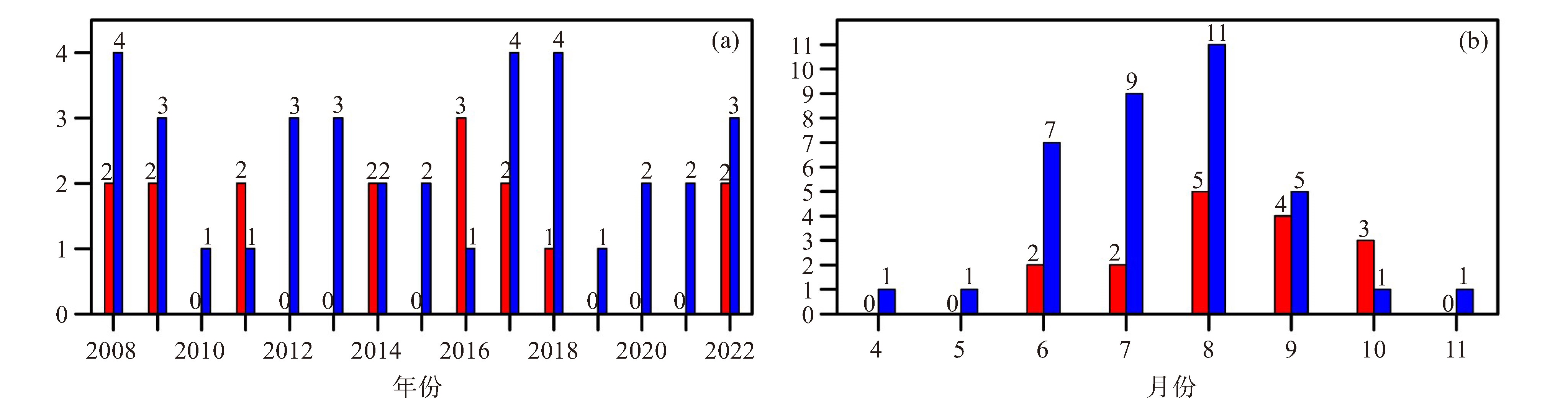
摘要: 为探究登陆广东空心台风基本特征规律,本文构建一种基于实况风场和热带气旋路径数据的空心台风客观识别算法,利用该算法识别2008—2022年登陆广东的空心台风并进行基本特征统计。研究发现,近15年登陆广东的空心台风均在南海中北部和西太平洋偏西地区生成,其在粤西登陆的比例最高(68%),且容易集中出现在夏末-秋季时段(75%)。空心台风可分为西北行、偏西行、偏北型和复杂型4类,其中西北行路径占比最高(62.5%)。进一步统计发现,在珠江口东侧、雷州半岛东北部-茂名登陆的空心台风,其主要大风区常分布在距离台风中心80~160 km的范围;而对于雷州半岛南部登陆的空心台风,其大风区则常分布在距中心约100~260 km的范围。研究还表明,空心台风相较于一般热带气旋具有尺寸偏大的倾向,且强度偏弱的热带气旋更有利于产生空心结构。此外,空心台风内圈风力与中心风力差值有随登陆强度增强而增大的趋势。最后,合成分析显示,空心台风对应的大尺度环流背景与非空心台风相比并无显著差异。Abstract: To explore the basic characteristics and patterns of landfalling hollow typhoons in Guangdong, this paper constructs an objective identification algorithm for landfalling hollow typhoons based on realtime wind field and tropical cyclone (TC) track data. Utilizing this algorithm, we identified hollow typhoons that made landfall in Guangdong from 2008 to 2022 and conducted a statistical analysis of their basic characteristics. The study found that all hollow typhoons that landed in Guangdong in the past 15 years originated from the central-northern South China Sea and the western part of the western Pacific Ocean. The highest proportion of landfalls occurred in western Guangdong (68%), with the majority concentrating during the late summer to autumn period (75%). These typhoons can be classified into four types: northwestward, westward, northward, and complex, with the northwestward type being the most prevalent (62.5%). Further statistical analysis reveals that for hollow typhoons making landfall on the eastern side of the Pearl River Estuary and in the area from the northeast of the Leizhou Peninsula to Maoming, the main gale regions are often distributed within a range of 80-160 km from the typhoon center. Conversely, for those making landfall in the southern part of Leizhou Peninsula, the gale regions are frequently distributed approximately 100-260 km from the center. The research also shows that hollow typhoons tend to be larger in size compared to normal TCs, and weaker TCs are more conducive to the formation of hollow structures. Furthermore, the difference between the inner-circle wind force and the central wind force of hollow typhoons tends to increase with the enhancement of landfall intensity. Composite analysis indicates that there is no significant difference in the large-scale circulation background between hollow typhoons and non-hollow typhoons.
-
Key words:
- tropical cyclone /
- hollow typhoon /
- objective algorithm /
- gale
-

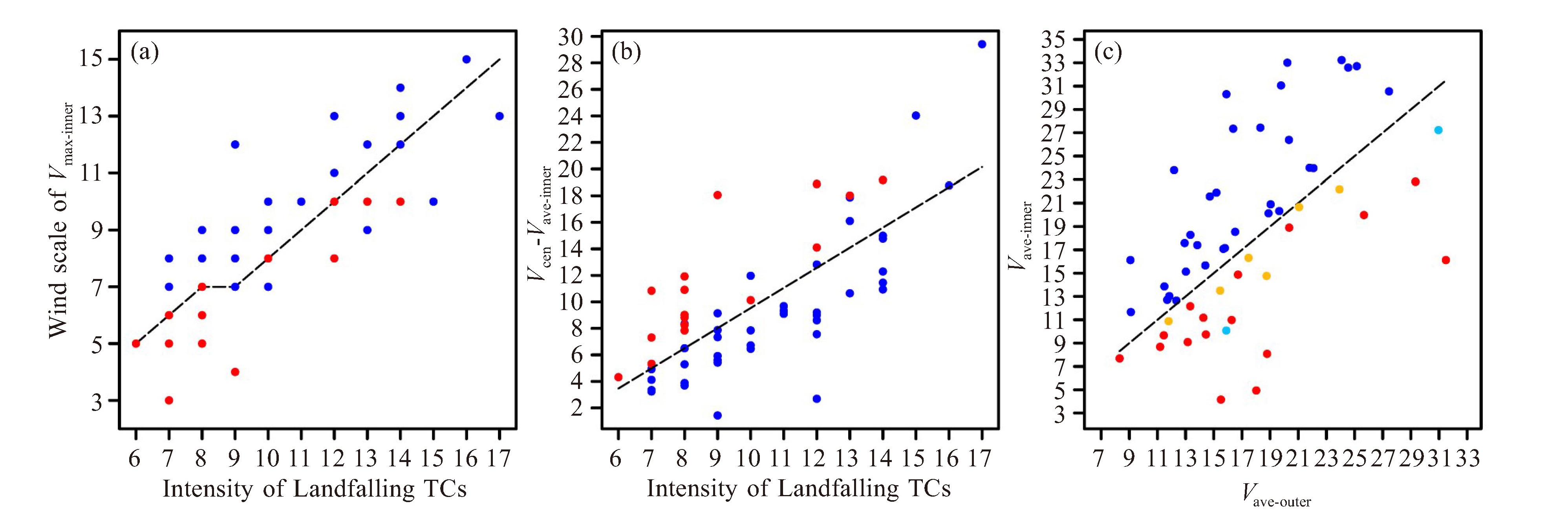
图 2 2008—2022年登陆广东不同强度TC登陆过程中内圈最大测风Vmax-inner的对应风级(虚线:客观算法约束条件1设定的不同强度TC内圈最大测风对应风级阈值,红点:空心台风,蓝点:非空心台风)(a),登陆时中心附近最大平均风力Vcen与内圈风力Vave-inner的风速差(单位:m·s-1,虚线:TC强度与风速差值的回归拟合线,红点:空心台风,蓝点:非空心台风)(b),登陆时的内外圈风力(单位:m·s-1,红点:空心台风,蓝点、黄点和浅蓝色点:非空心台风)(c)

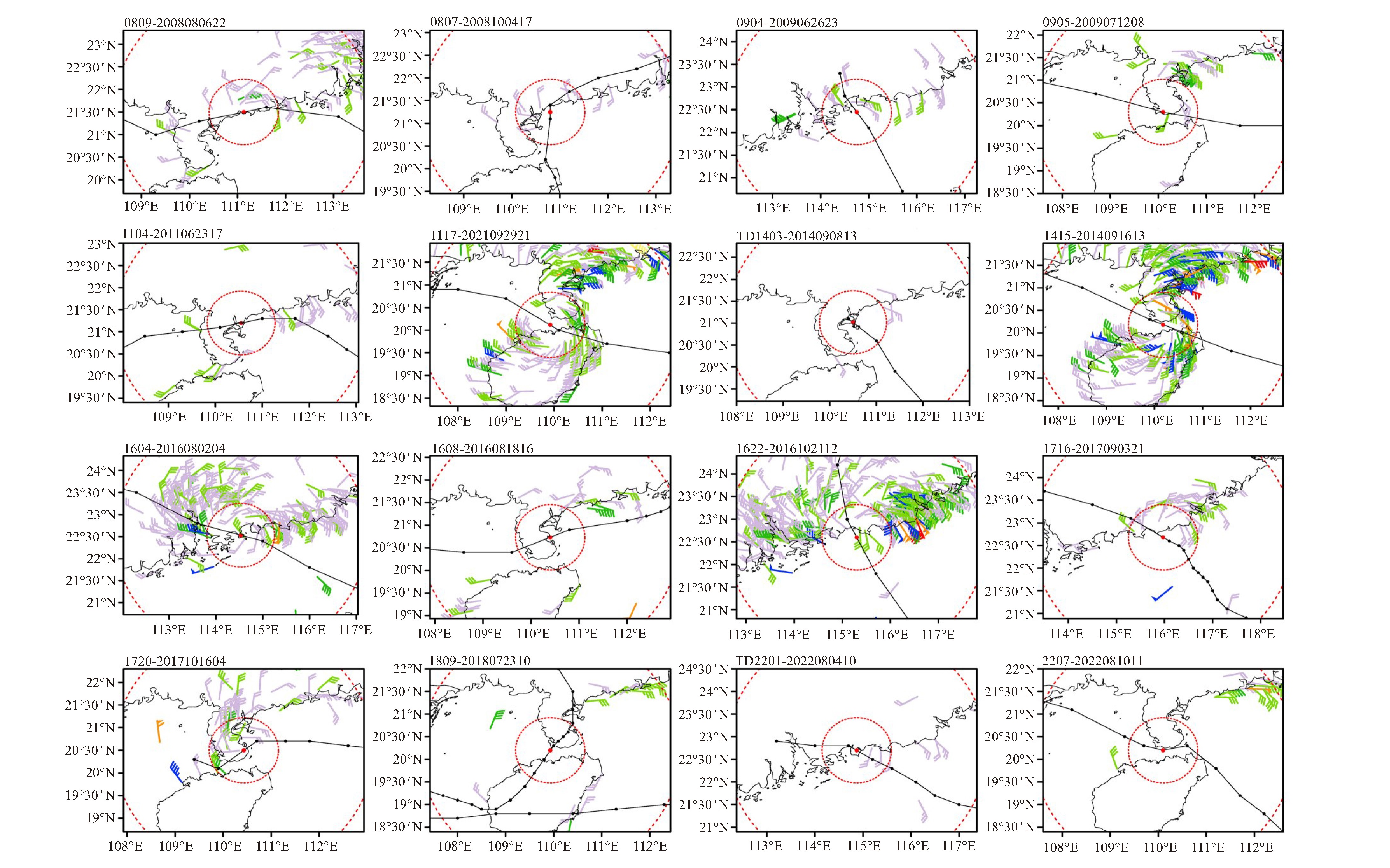
图 3 2008—2022年登陆广东客观识别空心台风在登陆过程中整点时次的风场分布图
已过滤掉小于5级的测风数据;每个子图的左上数字标注为“台风编号-风场时次”;红色虚线圈为TC内外圈范围,半径分别为80 km和300 km;风力量级为:浅紫色5级,浅绿色6级,绿色7级,蓝色8级,橙色9级,红色10级或以上。

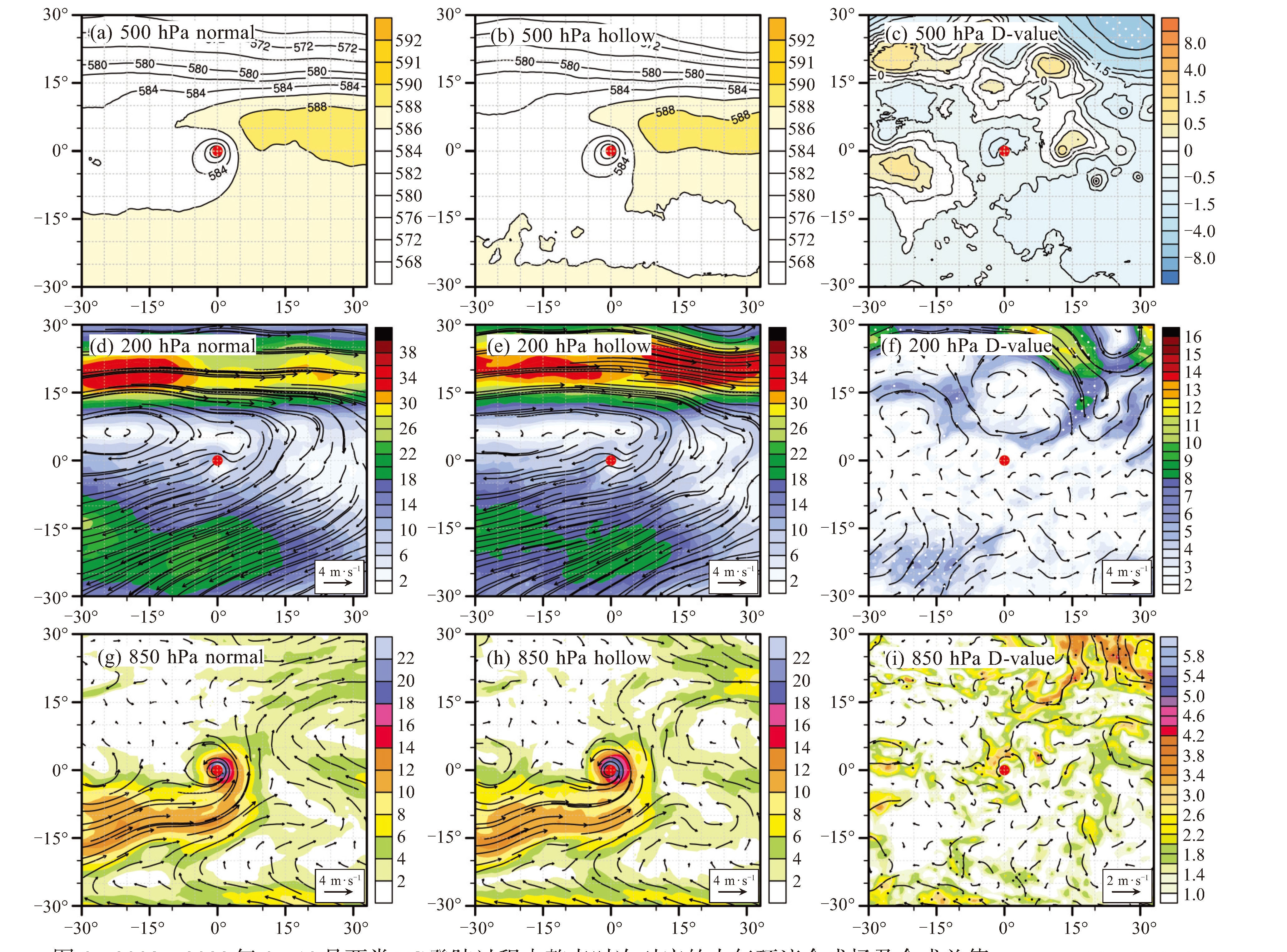
图 6 2008—2022年6—10月两类TC登陆过程中整点时次对应的大气环流合成场及合成差值
(a)~(c) 500 hPa高度场(单位:dagpm);(d)~(f) 200 hPa风场(填色;单位:m×s-1);(g)~(i) 850 hPa风场(填色;单位:m×s-1)。其中(a)、(d)、(g)代表非空心台风,(b)、(e)、(h)代表空心台风,(c)、(f)、(i)表示空心台风与非空心台风的气象要素合成差值。白色和黑色打点区域表示通过0.1的显著性水平检验,红点为TC中心。横、纵坐标分别代表距离TC中心的经、纬距,正值为向东或向北,负值为向西或向南。
表 1 不同强度热带气旋对应的回归拟合风速差阈值
TC登陆强度/级 风速差阈值/(m·s-1) TC登陆强度/级 风速差阈值/(m·s-1) 6 3.47 12 12.57 7 4.98 13 14.09 8 6.5 14 15.6 9 8.02 15 17.12 10 9.53 16 18.64 11 11.05 17 20.15  下载: 导出CSV
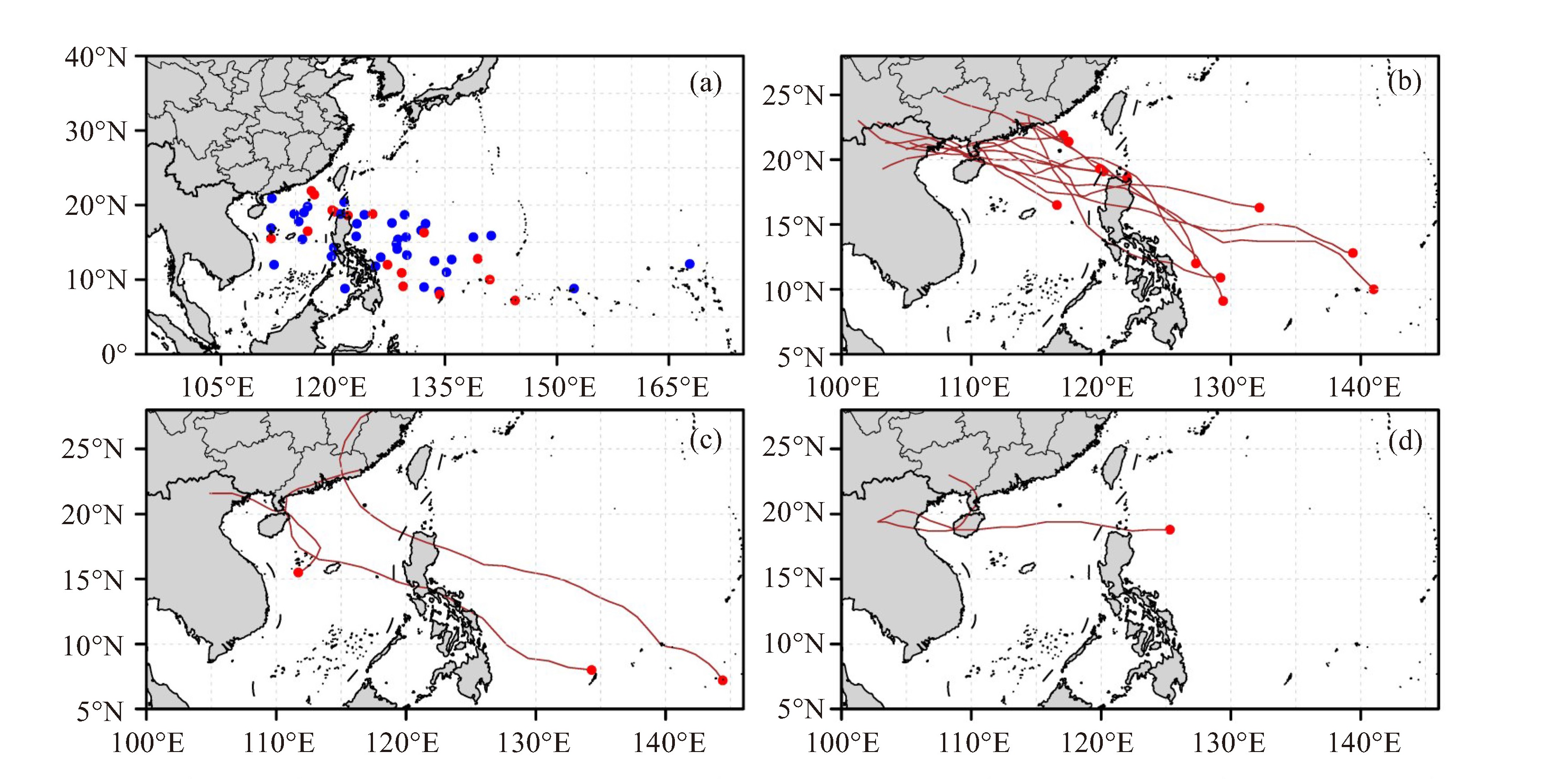
表 2 2008—2022年登陆广东客观识别空心台风信息统计表
TC编号 TC名称 生成源地 登陆点 最大强度 登陆强度 生成时间 登陆时间 生命周期 路径 0809 北冕 南海东北部 电白(粤西) STS TS 2008/08/03 20:00 2008/08/06 22:15 4 d 18 h 西北行 0817 海高斯 西太 吴川(粤西) TS TD 2008/09/29 02:00 2008/10/04 17:10 7 d 12 h 偏北行 0904 浪卡 西太 惠东(粤中) TS TS 2009/06/22 20:00 2009/06/26 22:50 4 d 12 h 西北行 0905 苏迪罗 西太 徐闻(粤西) TS TS 2009/07/10 20:00 2009/07/12 08:20 2 d 6 h 西行 1104 海马 西太 吴川(粤西) TS TS 2011/06/17 02:00 2011/06/23 16:50 8 d 18 h 西北行 1117 纳沙 西太 徐闻(粤西) STY TY 2011/09/23 08:00 2011/09/29 21:15 7 d 18 h 西北行 TD 1403 南海中东部 湛江(粤西) TD TD 2014/09/06 14:00 2014/09/08 13:10 2 d 西北行 1415 海鸥 西太 徐闻(粤西) STY STY 2014/09/11 02:00 2014/09/16 13:10 6 d 12 h 西北行 1604 妮妲 西太 深圳(粤中) TY TY 2016/07/29 20:00 2016/08/02 03:35 5 d 12 h 西北行 1608 电母 南海东北部 湛江(粤西) TS TS 2016/08/15 14:00 2016/08/18 15:40 4 d 18 h 西行 1622 海马 西太 汕尾(粤东) SuperTY TY 2016/10/14 20:00 2016/10/21 12:40 9 d 6 h 偏北行 1716 玛娃 南海东北部 陆丰(粤东) STS TS 2017/08/31 08:00 2017/09/03 21:20 4 d 6 h 西北行 1720 卡努 西太 徐闻(粤西) STY STS 2017/10/11 14:00 2017/10/16 03:40 5 d 西北行 1809 山神 西太 徐闻(粤西) TS TD 2018/07/16 08:00 2018/07/23 10:20 8 d 12 h 复杂 TD2201 南海东北部 惠东(粤中) TD TD 2022/08/03 17:00 2022/08/04 09:40 1 d 西北行 2207 木兰 南海中西部 湛江(粤西) TS TS 2022/08/08 20:00 2022/08/10 10:50 2 d 18 h 偏北行
下载: 导出CSV
-
[1] 陈联寿, 罗哲贤, 李英. 登陆热带气旋研究的进展[J]. 气象学报, 2004, 62(5): 541-549. [2] 刘扬, 张立生, 赵慧霞. 中国台风灾害损失与气象要素的关系分析[J]. 气象与环境科学, 2023, 46(4): 1-6. [3] 刘倩, 高路, 赵鹏, 等. 2000-2016年中国热带气旋灾害时空特征研究[J]. 中国防汛抗旱, 2020, 30(5): 50-57. [4] 陈联寿. 登陆台风特大暴雨成因分析[J]. 气象, 1977, 3(11): 10-13. [5] 程正泉, 陈联寿, 刘燕, 等. 1960—2003年我国热带气旋降水的时空分布特征[J]. 应用气象学报, 2007, 18(4): 427-434. [6] 程正泉, 陈联寿, 徐祥德, 等. 近10年中国台风暴雨研究进展[J]. 气象, 2005, 31(12): 3-9. [7] 陈联寿, 许映龙. 中国台风特大暴雨综述[J]. 气象与环境科学, 2017, 40(1) : 3-10. [8] 郑运霞, 应明, 李永平. 影响广东省中部沿海热带气旋大风气候特征和重现期分析[J]. 海洋与湖沼, 2014, 45(1): 157-165. [9] 刘婧茹, 李英, 孟青, 等. 中国东南地区热带气旋大风及其伴随天气的统计特征[J]. 大气科学, 2023, 47(4): 1 024-1 038. [10] 贾宁, 刘强, 石先武, 等. 基于现场调查的台风"天鸽"(1713)和台风"山竹"(1822)风暴潮灾害影响和致灾对比分析[J]. 海洋预报, 2022, 39(5): 94-99. [11] 陈瑞闪. 试论台风的"空心"现象[J]. 海洋预报, 1987(1): 68-72. [12] 林小红, 吴建成, 刘通易, 等. 三个典型登闽空心结构台风强降水分布差异分析[J]. 气象与环境学报, 2019, 35(1): 10-17. [13] WEATHERFORD C L, GRAY W M. Typhoon structural variability[M]. Colorado State University Atmospheric Science Paper, 1984, 391, 77 pp. [14] CHEN Y L, WU C C. On the two types of tropical cyclone eye formation: Clearing formation and banding formation[J]. Mon Wea Rev, 2022, 150(6): 1 457-1 473. [15] LANDER M A. A tropical cyclone with a very large eye[J]. Mon Wea Rev, 1997, 127(1): 137-142. [16] 张长安, 郑秀专, 潘娅婷. 台风圣帕的空心现象分析[J]. 气象, 2008, 34(4): 48-52. [17] 郭达烽, 周芳, 陈翔翔, 等. 登陆台风"麦德姆"的空心结构及其特征[J]. 气象与环境学报, 2017, 33(3): 10-20. [18] 李英, 钱传海, 陈联寿. Sepat台风(0709)登陆过程中眼放大现象研究[J]. 气象学报, 2009, 67(5): 799-810. [19] 胡春蕾. 登陆台风"蒲公英"空心结构分析[C]//中国气象学会. 推进气象科技创新加快气象事业发展——中国气象学会2004年年会论文集(下册). 北京: 气象出版社, 2004: 1. [20] 胡恒, 王远超, 陈明璐. 0812空心台风鹦鹉(NURI)特征分析[J]. 气象研究与应用, 2010, 31(S2): 31-32. [21] 黄昌兴, 周芳, 薛谌彬. 台风"潭美"(2013)偏心不对称结构特征分析及数值模拟[J]. 气象与减灾研究, 2014, 37(2): 11-18. [22] 郑颖青, 吴启树, 林笑茹, 等. 近106a来登陆福建台风的统计分析[J]. 台湾海峡, 2006, 25(4): 541-547. [23] 刘天绍, 刘孙俊, 杨玺, 等. 1951-2015影响广东沿海台风的统计分析[J]. 海洋预报, 2018, 35(4): 68-74. [24] 陈劲, 杨玺, 汤振鹏. 登陆广东的台风强度和路径特征分析[J]. 气象研究与应用, 2018, 39(3): 35-37. [25] 林良勋. 广东省天气预报技术手册[M]. 北京: 气象出版社, 2006. [26] 毛绍荣, 张东, 梁健, 等. 广东近海台风路径异常的统计特征[J]. 应用气象学报, 2003, 14(3): 348-355. [27] 王娟怀, 李梓贤, 唐力生, 等. 1604号登陆台风"妮妲"的特点及其成因分析[J]. 广东气象, 2018, 40(5): 10-14. [28] 杨国杰, 沙天阳. 1604号台风"妮妲"远离后珠三角强降水的原因分析[J]. 广东气象, 2017, 39(3): 1-5. [29] KNAPP R K, VELDEN C S, WIMMERS A J. A global climatology of tropical cyclone eyes[J]. Mon Wea Rev, 2018, 146(7): 2 089-2 101. [30] YING M, ZHANG W, YU H, et al. An overview of the China Meteorological Administration tropical cyclone database[J]. J Atmos Oceanic Technol, 2014, 31(2): 287-301. [31] LU X Q, YU H, YING M, et al. Western North Pacific tropical cyclone database created by the China Meteorological Administration[J]. Adv Atmos Sci, 2021, 38(4): 690-699. [32] 中国气象局. 热带气旋年鉴(2008—2020年). 北京: 气象出版社, 2009-2021. [33] HERSBACH H, BELL B, BERRISFORD P, et al. The ERA5 global reanalysis. Quarterly journal of the royal meteorological society, 2020, 146(730), 1 999-2 049. [34] 陈联寿, 丁一汇. 西太平洋台风概论[M]. 北京: 科学出版社, 1979. [35] 吴联要, 雷小途. 内核及外围尺度与热带气旋强度关系的初步研究[J]. 热带气象学报, 2012, 28(5): 719-725. [36] 吴磊. 西北太平洋热带气旋尺度特征的研究[D]. 南京: 南京大学, 2013. [37] 梁莉, 崔晓鹏, 王成鑫, 等. 我国登陆热带气旋引起的大陆地面风场分布[J]. 大气科学, 2018, 42 (1): 96-108. [38] 海军南海舰队司令部气象台. 秋季影响南海的台风[J]. 气象, 1976(9): 24-26. [39] 郭青, 黄旭辉, 刘三梅, 等. 台风登陆广东前后的地闪特征[J]. 广东气象, 2020, 42(6): 44-47. -

 点击查看大图
计量
- 文章访问数: 6
- HTML全文浏览量: 1
- PDF下载量: 0
- 被引次数: 0
 粤公网安备 4401069904700003号