


A Sensitivity Study on the Initial Field for the Track and Heavy Precipitation Forecast of Typhoon Haikui (2012) after Entering the Saddle Field
-
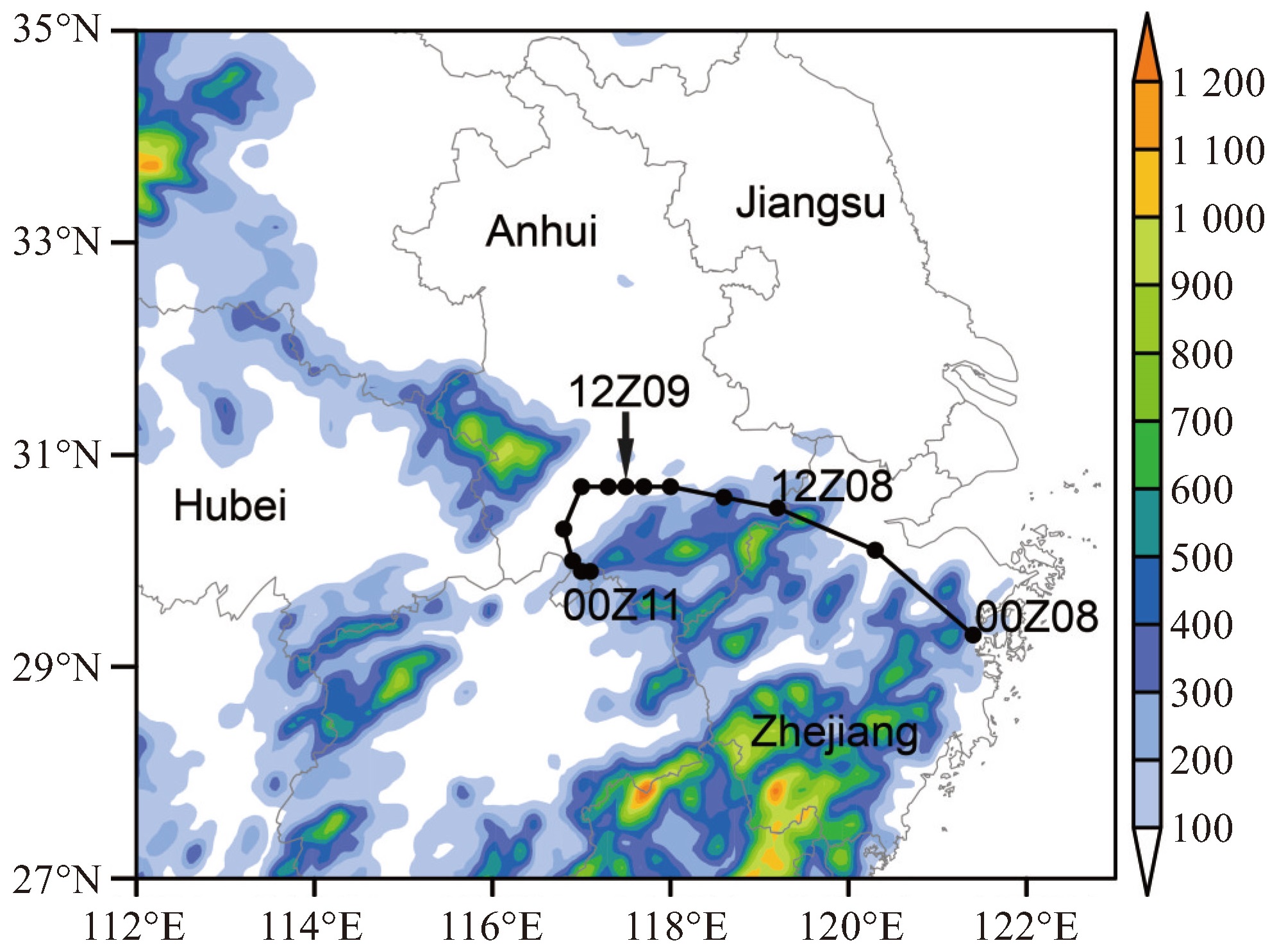
摘要: 台风“海葵”(2012)受鞍型场影响,在安徽南部维持少动,引发极端降水。为了探究“海葵”进入鞍型场后,其路径及降水预报对模式初始场的敏感性,基于WRF(Weather Research & Forecasting)模式和集合卡尔曼滤波(EnKF,Ensemble Kalman Filter)同化系统,对“海葵”开展了集合预报试验和敏感性试验。结果表明:(1)“海葵”登陆浙江西北行进入安徽境内后,集合预报路径主要分为滞留型、转向东行型和西行型,其中滞留型路径与“海葵”观测路径基本一致。(2)与台风自身环流相比,初始条件中环境场的差异是导致试验中台风移动差异的关键因素。台风移动对初始场中西北模拟区域的大陆高压和中纬度低槽更加敏感。(3)当初始场中大陆高压和低槽强度相当时,减弱的台风环流一直处于大陆高压和副热带高压之间,导致台风在安徽南部停滞,并与冷空气相互作用在皖南-赣北产生强降水。而当初始场中大陆高压弱且低槽较强时,24 h预报中台风虽处于鞍型场中,但大陆高压与副热带高压均偏弱。随着低槽南下,大陆高压减弱西退,副热带高压位置偏东,导致台风转向东北行,在江苏境内产生强降水;反之,当大陆高压强但低槽较弱时,台风持续西行,冷空气受高压阻挡未能直接影响台风降水,导致皖南地区降水相对偏弱。
-
关键词:
- 台风“海葵”(2012) /
- 鞍型场 /
- 集合预报
Abstract: Typhoon Haikui (2012) was influenced by a saddle-point flow field, resulting in nearly stationary movement in southern Anhui and causing extreme rainfall. To examine the sensitivity of the track and precipitation forecast of Haikui to the model's initial conditions after entering the saddle-point region, ensemble forecast experiments and sensitivity experiments were conducted for Haikui using the Weather Research & Forecasting (WRF) model coupled with an Ensemble Kalman Filter (EnKF) assimilation system. The results show that: (1) After Typhoon Haikui made landfall in Zhejiang and moved northwestward into Anhui, typhoon tracks forecast by ensemble forecasting experiments can mainly be divided into the stagnation type, the eastward-turning type, and the westward-moving type. The stagnation tracks are most similar to the observed track of Haikui. (2) Compared with the circulation of the typhoon itself, differences in the environmental field of initial conditions are the key factor causing variations in typhoon motion in the experiments. The typhoon's movement is more sensitive to the continental high-pressure system and mid-latitude trough in the northwestern part of the simulation domain. (3) When the intensities of the continental high and trough are comparable in the initial field, the weakened typhoon circulation remains between the continental high and the subtropical high, leading to stagnation over southern Anhui. This, combined with cold air interaction, results in heavy rainfall in southern Anhui and northern Jiangxi. When the continental high is weak and the trough is strong in the initial field, the typhoon is forecasted to be in a saddle-point field in the 24-hour forecast. However, both the continental high and the subtropical high are relatively weak. As the trough moves southward, the continental high weakens and retreats westard, and the subtropical high shifts eastward. The typhoon then turns northeastward, resulting in heavy rainfall in Jiangsu. Conversely, when the continental high is strong but the trough is weak, the typhoon continues moving westward. The influence of the trough and cold air shifts to the north. Cold air is blocked by the high pressure and fails to directly interact with the typhoon's circulation, resulting in relatively weaker precipitation in southern Anhui.-
Key words:
- typhoon Haikui (2012) /
- saddle field /
- ensemble forecasts
-

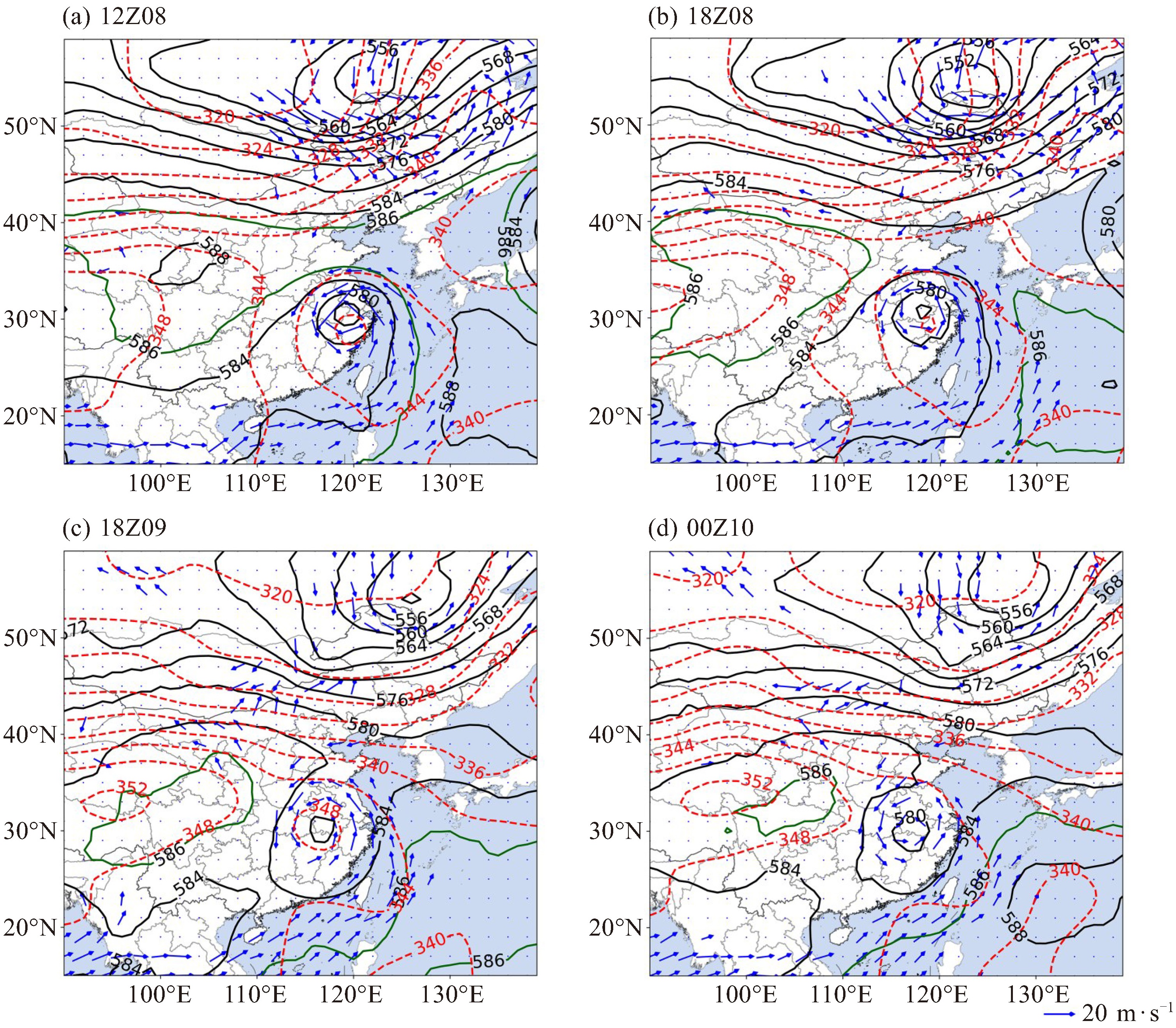
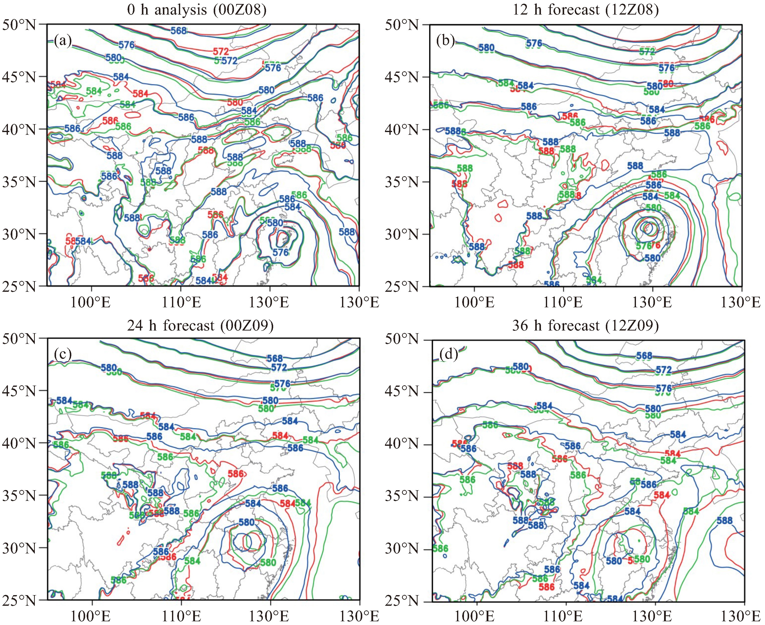
图 3 2012年8月8日12时(a)、8日18时(b)、9日18时(c)和10日00时(d)500 hPa高度场(黑色实线;单位:dagpm;其中绿色实线代表586 dagpm)、假相当位温场(红色虚线;单位:K)和850 hPa风场(蓝色箭矢;单位:m∙s-1)

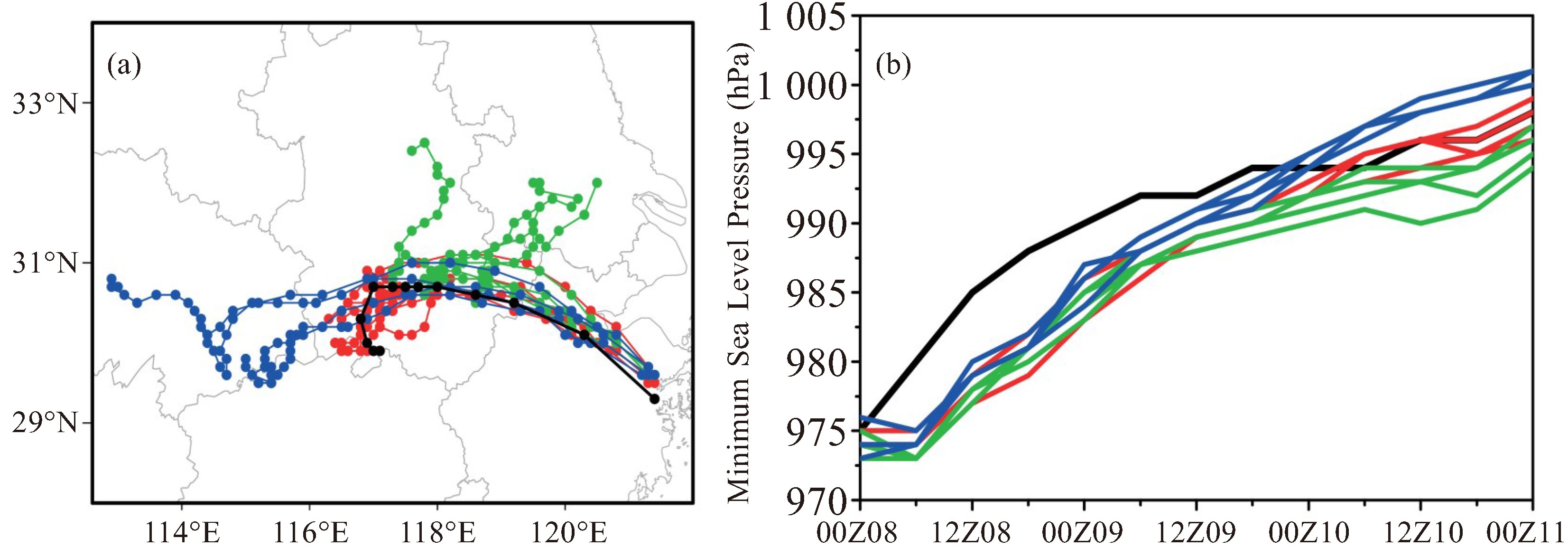
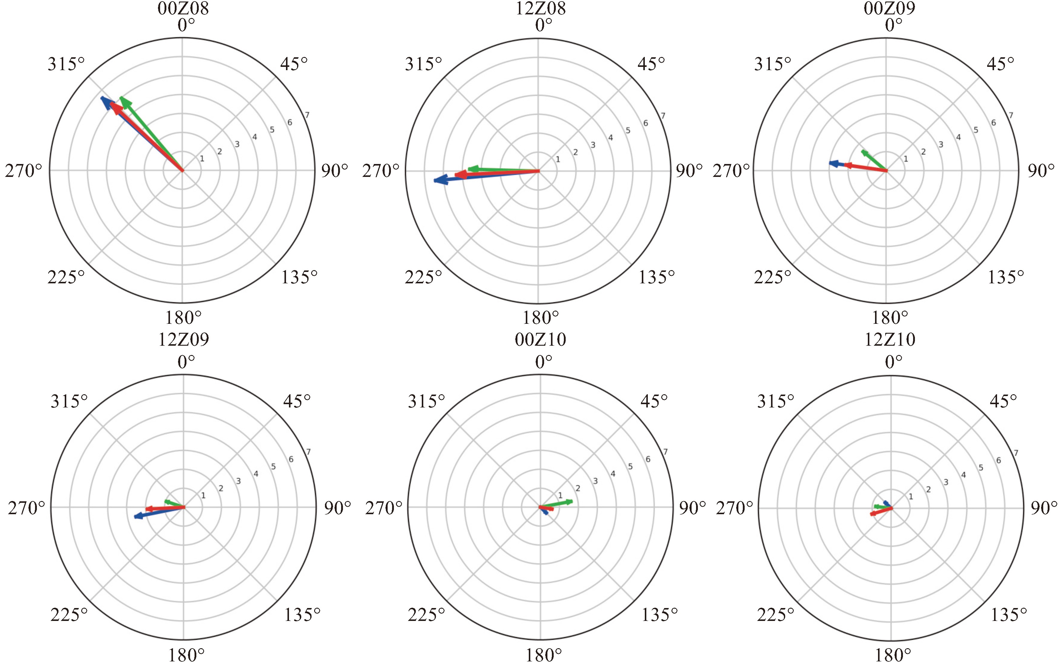
图 4 12个代表性集合成员的台风路径预报(a)和强度预报(b)与观测的对比(黑色:观测;红色:滞留安徽类台风;绿色:转向东行类台风;蓝色:西行类台风;图a中圆点代表台风中心位置,黑点时间间隔为6 h,其他颜色圆点时间间隔为3 h)

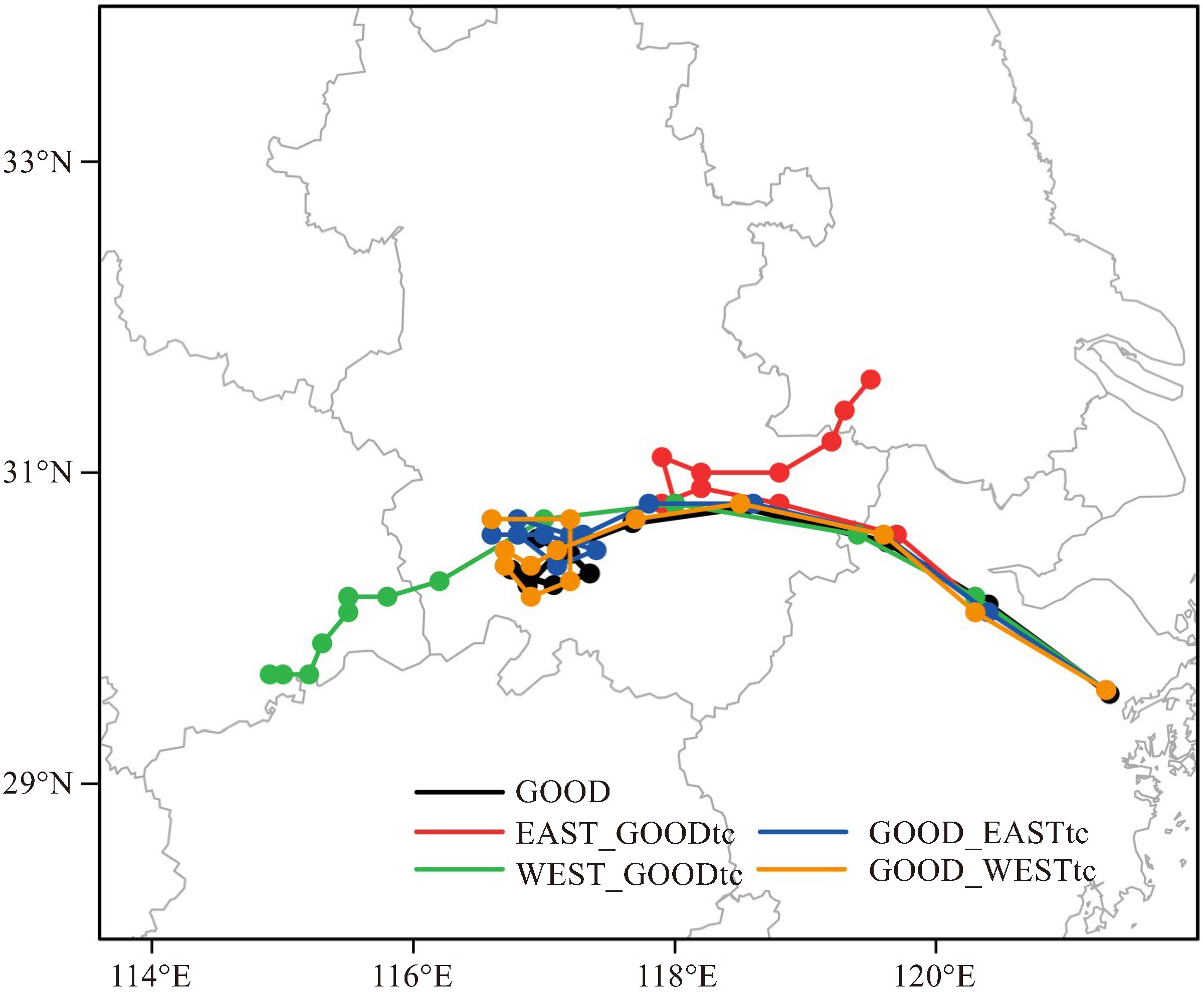
图 7 台风环流替代试验和GOOD试验预报的台风移动路径对比(黑色:GOOD试验;红色:EAST_GOODtc试验;绿色:WEST_GOODtc试验;蓝色:GOOD_EASTtc试验;橙色:GOOD_WESTtc试验)

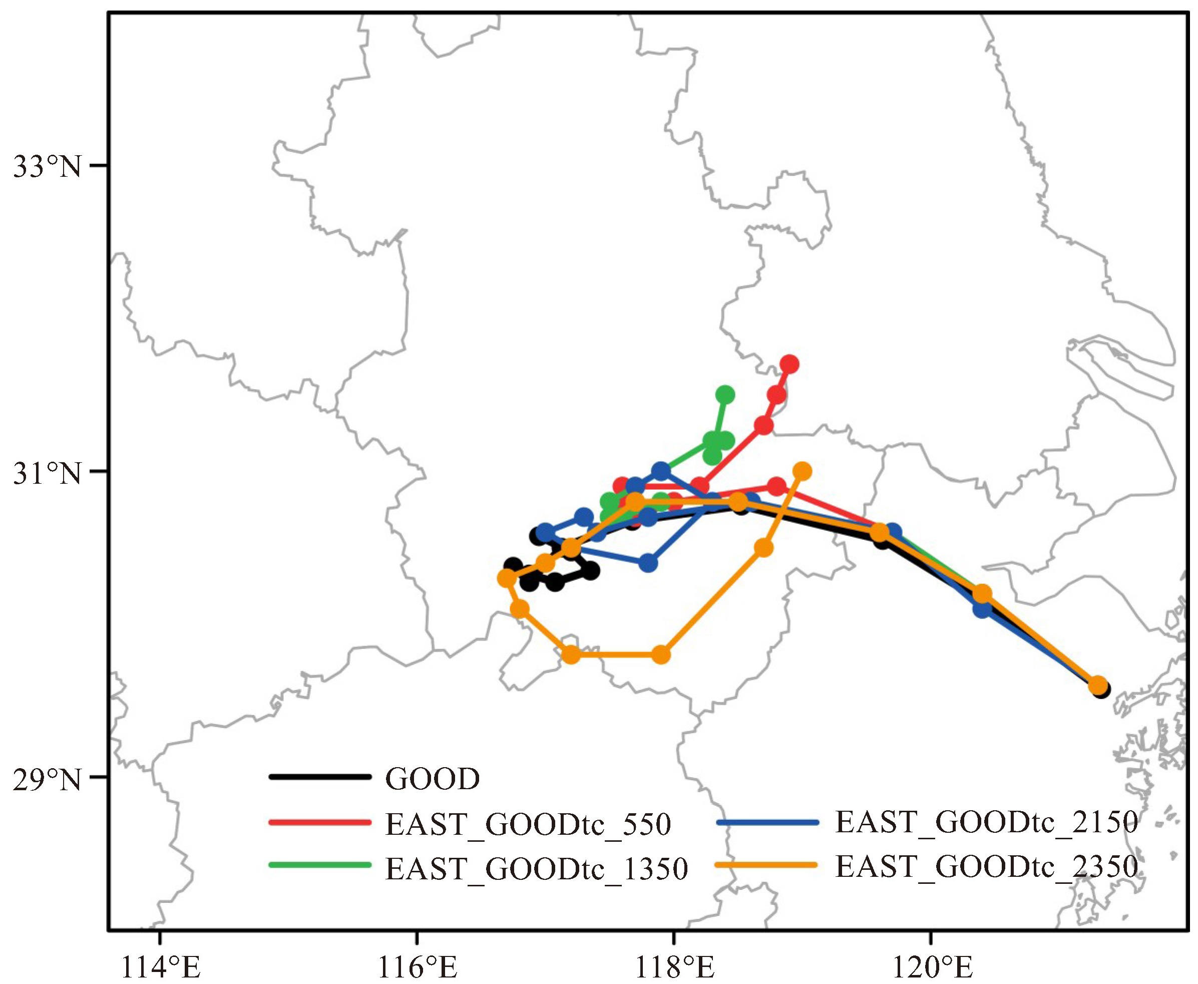
图 8 不同替代半径试验与GOOD试验预报的台风移动路径对比(黑色:GOOD试验;红色:EAST_GOODtc_550试验;绿色:EAST_GOODtc_1350试验;蓝色:EAST_GOODtc_2150试验;橙色:EAST_GOODtc_2350试验)

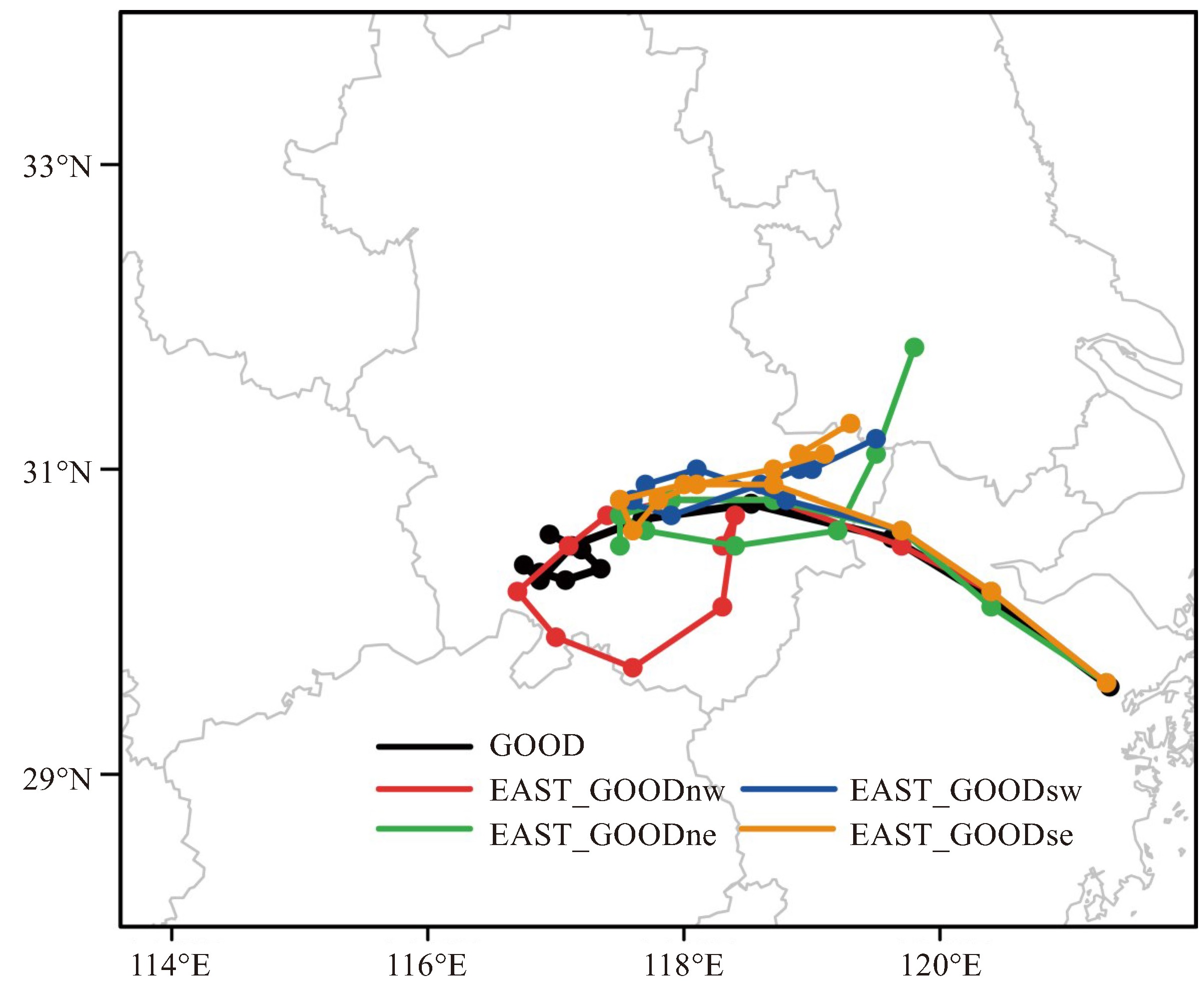
图 9 不同替代区域试验与GOOD试验预报的台风移动路径对比(黑色:GOOD试验;红色:EAST_GOODnw试验;绿色:EAST_GOODne试验;蓝色:EAST_GOODsw试验;橙色:EAST_GOODse试验)

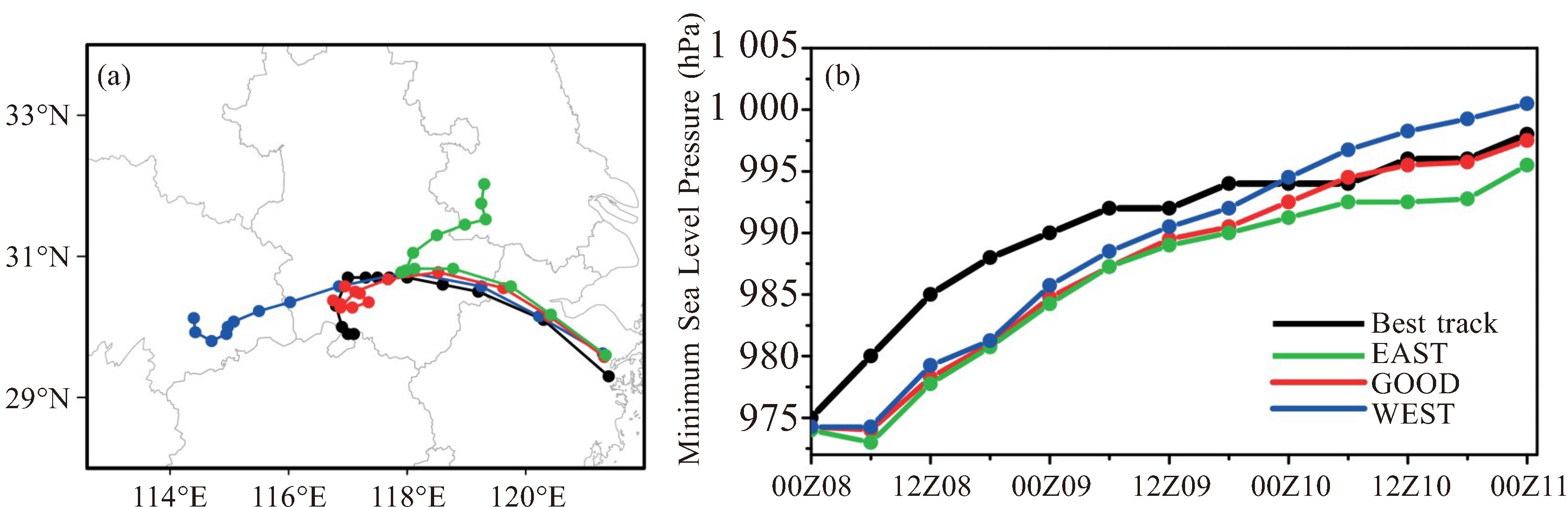
图 10 2012年8月8日00时三组试验中500 hPa位势高度的分析场(a)和12 h(b)、24 h(c)和48 h(d)预报场
(红色:GOOD试验;绿色:EAST试验;蓝色:WEST试验;单位:dagpm)

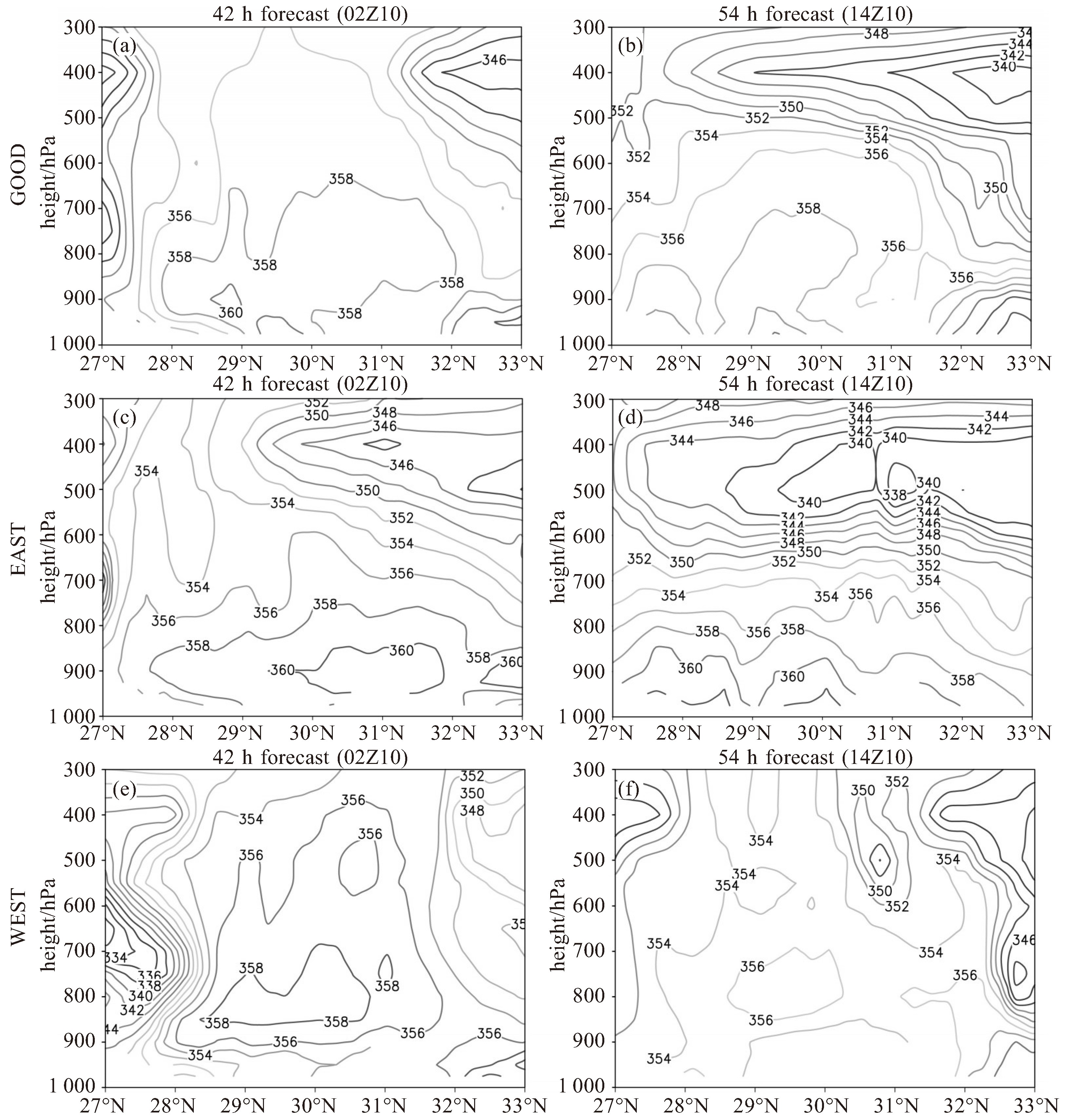
图 12 三组试验42 h(a、c、e)和54 h(b、d、f)预报的假相当位温(单位:K)沿117 °E的垂直剖面图(a、b:GOOD试验;c、d:EAST试验;e、f:WEST试验)
表 1 初始场敏感性试验设计方案
试验名称 试验设计及初始场描述 GOOD 将滞留型路径的4个代表性集合成员的分析场进行平均,作为试验初始场 EAST 将转向东行型路径的4个代表性集合成员的分析场进行平均,作为试验初始场 WEST 将西行型路径的4个代表性集合成员的分析场进行平均,作为试验初始场 EAST_GOODtc 同EAST试验,但将距离台风中心250 km范围内的初始场用GOOD试验的初始场替代 WEST_GOODtc 同WEST试验,但将距离台风中心250 km范围内的初始场用GOOD试验的初始场替代 GOOD_EASTtc 同GOOD试验,但将距离台风中心250 km范围内的初始场用EAST试验的初始场替代 GOOD_WESTtc 同GOOD试验,但将距离台风中心250 km范围内的初始场用WEST试验的初始场替代 EAST_GOODtc_550 同EAST_GOODtc试验,但将替代范围增加到550 km EAST_GOODtc_1350 同EAST_GOODtc试验,但将替代范围增加到1 350 km EAST_GOODtc_2150 同EAST_GOODtc试验,但将替代范围增加到2 150 km EAST_GOODtc_2350 同EAST_GOODtc试验,但将替代范围增加到2 350 km EAST_GOODnw 同EAST试验,但将西北区域初始场用GOOD试验初始场替代 EAST_GOODsw 同EAST试验,但将西南区域初始场用GOOD试验初始场替代 EAST_GOODne 同EAST试验,但将东北区域初始场用GOOD试验初始场替代 EAST_GOODse 同EAST试验,但将东南区域初始场用GOOD试验初始场替代  下载: 导出CSV
-
[1] Wang Y, Zhou Z, Zhang Q, et al. Main meteorological disasters and their impacts on the economic and societal developments in china[J]. International Journal of Risk Assessment & Management, 2008, 8(4): 384-394. [2] Chen X Y, Wu L G, Zhang J Y. Increasing duration of tropical cyclones over China[J]. Geophysical Research Letters, 2011, 38(2): L02708. [3] 陈联寿, 罗哲贤. 影响热带气旋结构和运动的两类因子的数值研究[J]. 气象学报, 1996, 54(4): 409-416. [4] 周玲丽, 翟国庆, 王东海, 等. 0713号"韦帕"台风暴雨的中尺度数值研究和非对称性结构分析[J]. 大气科学, 2011, 35(6): 1 046-1 056. [5] Dong M, Chen L, Li Y, et al. Rainfall reinforcement associated with landfalling tropical cyclones[J]. Journal of Atmospheric Sciences, 2010, 67(11): 3 541-3 558. [6] 孟智勇, 徐祥德, 陈联寿. 9406号台风与中纬度系统相互作用的中尺度特征[J]. 气象学报, 2002, 60(1): 31-39. [7] 孙建华, 张小玲, 卫捷, 等. 20世纪90年代华北大暴雨过程特征的分析研究[J]. 气候与环境研究, 2005, 10(3): 492-506. [8] Komaromi W A, Doyle J D. Tropical cyclone outflow and warm core structure as revealed by HS3 dropsonde data[J]. Monthly Weather Review, 2017, 145(4): 1 339-1 359. [9] Kumar S, Lal P, Kumar A. Turbulence of tropical cyclone'Fani'in the Bay of Bengal and Indian subcontinent[J]. Natural Hazards, 2020, 103(1): 1 613-1 622. [10] Abraham J, Strapp J W, Fogarty C, et al. Extratropical transition of hurricane Michael: An aircraft investigation[J]. Bulletin of the American Meteorological Society, 2004, 85(9): 1 323-1 340. [11] Deng D F, Ritchie E A. Rainfall characteristics of recurving tropical cyclones over the western North Pacific[J]. Journal of Climate, 2018, 31 (2): 575-592. [12] Liu Q, Li T, Zhou W C. Impact of 10-60-day low-frequency steering flows on straight northward-moving typhoon tracks over the western North Pacific[J]. Journal of Meteorological Research, 2018, 32(3): 394-409. [13] 程正泉, 陈联寿, 徐祥德, 等. 近10年中国台风暴雨研究进展[J]. 气象, 2005, 31(12): 3-9. [14] 周懿, 郭云云, 余芳. 四川盆地一次西风槽和台风共同作用暴雨过程分析[J]. 高原山地气象研究, 2020, 40(2): 11-17. [15] Khain A, Cohen N, Lynn B, et al. Possible aerosol effects on lightning activity and structure of hurricanes[J]. Journal of Atmospheric Sciences, 2008, 65(12): 3 652-3 677. [16] 任晨平. 强热带风暴"碧利斯"(0604)暴雨增幅及其云微物理过程数值模拟与诊断[D]. 南京: 南京信息工程大学, 2013. [17] 陈联寿, 许映龙. 中国台风特大暴雨综述[J]. 气象与环境科学, 2017, 40(1): 3-10. [18] 郑峰, 张灵杰. 双台风相互作用引发台风强度突增现象的观测分析[J]. 气候变化研究快报, 2013, 2(2): 71-73. [19] Hoskins B J, McIntyre M E, Pobertson A W. On the use and significance of isentropic potential vorticity maps[J]. Quarterly Journal of the Royal Meteorological Society, 1985, 111(470): 877-946. [20] 张兴强, 丁治英, 王焱. 高空急流与中纬度系统影响下台风暴雨的研究现状[J]. 气象, 2001, 27(8): 3-8. [21] Anthes R A. Tropical cyclones: their evolution, structure and effects[M]. Boston: American Meteorological Society, 1982, 1-208. [22] 王海平. 高空冷涡对台风烟花(2106)路径的影响[J]. 应用气象学报, 2023, 34(5): 586-597. [23] 王斌, Elberry R L, 王玉清, 等. 热带气旋运动的动力学研究进展[J]. 大气科学, 1998, 22(4): 535-547. [24] 徐昝敏, 李天明. 热力和动力环境因子对与台风"海燕"路径相似的两类台风强度的相对贡献[J]. 大气科学学报, 2024, 47(2): 224-234. [25] Chan J C L, Lam H. Performance of ECMWF model in predicting the movement of Typhoon Wayne (1986)[J]. Weather & Forecasting, 1989, 4(2): 234-245. [26] Lander M A. Description of a monsoon gyre and its effects on the tropical cyclones in the western North Pacific during August 1991[J]. Weather & Forecasting, 1994, 9(4): 640-654. [27] Yang C C, Wu C C, Chou K H, et al. Binary interaction between Typhoons Fengshen (2002) and Fungwong (2002) based on the potential vorticity diagnosis[J]. Monthly Weather Review, 2008, 136(12): 4 593-4 611. [28] 周冠博, 柳龙生, 董林, 等. 2020年西北太平洋台风活动特征和预报难点分析[J]. 气象, 2022, 48(4): 504-515. [29] Li T, Zhu Y. Analysis and modeling of tropical cyclone motion (Ⅰ): asymmetric structure and sudden change of tracks[J]. Science China-Chemistry, 1991, 34: 222-233. [30] 雷小途, 陈联寿. 热带气旋与中纬度环流系统相互作用的研究进展[J]. 热带气象学报, 2001, 17(4): 452-461. [31] 孟智勇, 徐祥德, 陈联寿. 台湾岛地形诱生次级环流系统对台风异常运动的影响机制[J]. 大气科学, 1998, 22(2): 156-168. [32] Holland G J. Tropical cyclone motion: environmental interaction plus a beta effect[J]. Journal of Atmospheric Sciences, 1983, 40(2): 328-342. [33] 郑浩阳, 涂建文, 詹棠, 等. "韦森特"台风的路径和强度分析[J]. 广东气象, 2014, 36(1): 12-19. [34] 刘志红, 姜勇强. 鞍型场对热带气旋移动路径影响的研究[J]. 气象与环境科学, 2014, 37(2): 14-22. [35] 吕梅, 姜勇强, 邹力, 等. 热带气旋"芭玛"异常路径分析[J]. 解放军理工大学学报(自然科学版), 2012, 13(1): 106-113. [36] 吕心艳, 许映龙, 董林, 等. 2018年西北太平洋台风活动特征和预报难点分析[J]. 气象, 2021, 47(3): 359-372. [37] 姚丽娜, 吴海英, 韩桂荣, 等. 热带气旋衰减后造成区域性暴雨的气候特征及分型研究[J]. 暴雨灾害, 2017, 36(5): 453-459. [38] Zhou F F, Yamaguchi M, Qin X H. Possible sources of forecast errors generated by the global/regional assimilation and prediction system for landfalling tropical cyclones. Part Ⅰ: Initial uncertainties[J]. Advances in Atmospheric Sciences, 2016, 33(7): 841-851. [39] 周菲凡, 叶一苇, 张晗, 等. 不同尺度初始误差对2021年台风烟花路径和强度模拟预报的影响[J]. 大气科学, 2025, 49(2): 550-564. [40] Liu L, Feng J, Ma L, et al. Ensemble-based sensitivity analysis of track forecasts of typhoon In-fa (2021) without and with model errors in the ECMWF, NCEP, and CMA ensemble prediction systems[J]. Atmospheric Research, 2024, 107596. [41] Torn R D, Hakim G J. Initial condition sensitivity of western Pacific extratropical transitions determined using ensemble-based sensitivity analysis[J]. Monthly Weather Review, 2009, 137(10): 3 388-3 406. [42] 邱学兴, Zhang F Q. EnKF同化雷达资料对一次极端局地强降水事件预报影响及其可预报性分析[J]. 中国科学: 地球科学, 2016, 46(1): 27-42. [43] Zhang F Q, Weng Y H. Predicting hurricane intensity and associated hazards: A five-year real-time forecast experiment with assimilation of airborne Doppler radar observations[J]. Bulletin of the American Meteorological Society, 2015, 96(1): 25-33. [44] Ying M, Zhang W, Yu H, et al. An overview of the China Meteorological Administration tropical cyclone database[J]. The Journal of Atmospheric and Oceanic Technology, 2014, 31(2): 287-301. [45] Lu X Q, Yu H, Ying M, et al. Western North Pacific tropical cyclone database created by the China Meteorological Administration[J]. Advances in Atmospheric Sciences, 2021, 38(4): 690-699. [46] Zhang F Q, Meng Z Y, Aksoy A. Tests of an ensemble Kalman filter for mesoscale and regional-scale data assimilation. Part Ⅰ: Perfect-model experiments[J]. Monthly Weather Review, 2006, 134(2): 72-736. [47] Meng Z Y, Zhang F Q. Tests of an ensemble Kalman filter for mesoscale and regional-scale data assimilation. Part Ⅱ: Imperfect-model experiments[J]. Monthly Weather Review, 2007, 135(4): 1 403-1 423. [48] Meng Z Y, Zhang F Q. Tests of an ensemble Kalman filter for mesoscale and regional-scale data assimilation. Part Ⅲ: comparison with 3DVAR in a real-data case study[J]. Monthly Weather Review, 2008, 136(2): 522-540. [49] Chan J C L, Gray W M. Tropical cyclone movement and surrounding flow relationships[J]. Monthly Weather Review, 1982, 110(10): 1 354-1 374. [50] Dong K, Neumann C J. The relationship between tropical cyclone motion and environmental geostrophic flows[J]. Monthly Weather Review, 1986, 114(1): 115-122. [51] Velden C S, Leslie L M. The basic relationships between tropical cyclone intensity and the depth of the environmental steering layer in the Australian region[J]. Weather & Forecasting, 1991, 6(2): 244-253. [52] 吴海英, 曾明剑, 王卫芳, 等. 1211号"海葵"台风登陆后引发两段大暴雨过程的对比分析[J]. 大气科学学报, 2015, 38(5): 670-677. [53] Fudeyasu H, Wang Y, Montgomery M T. Effects of precipitation on hurricane intensity and structure under idealized conditions[J]. Journal of Atmospheric Sciences, 2011, 68(3): 639-660. [54] Chen X, Wang Y, Zhao K. Effects of precipitation and cold pool on the motion of tropical cyclones under idealized conditions[J]. Journal of Atmospheric Sciences, 2019, 76(3): 785-805. [55] Emanuel K. 100 years of progress in tropical cyclone research[J]. Meteorological Monographs, 2018, 59: 15.1-15.68. -

 点击查看大图
计量
- 文章访问数: 3
- HTML全文浏览量: 3
- PDF下载量: 2
- 被引次数: 0
 粤公网安备 4401069904700003号