


Statistical Characteristics of Typhoons Affecting Xiamen from 2008 to 2023
-
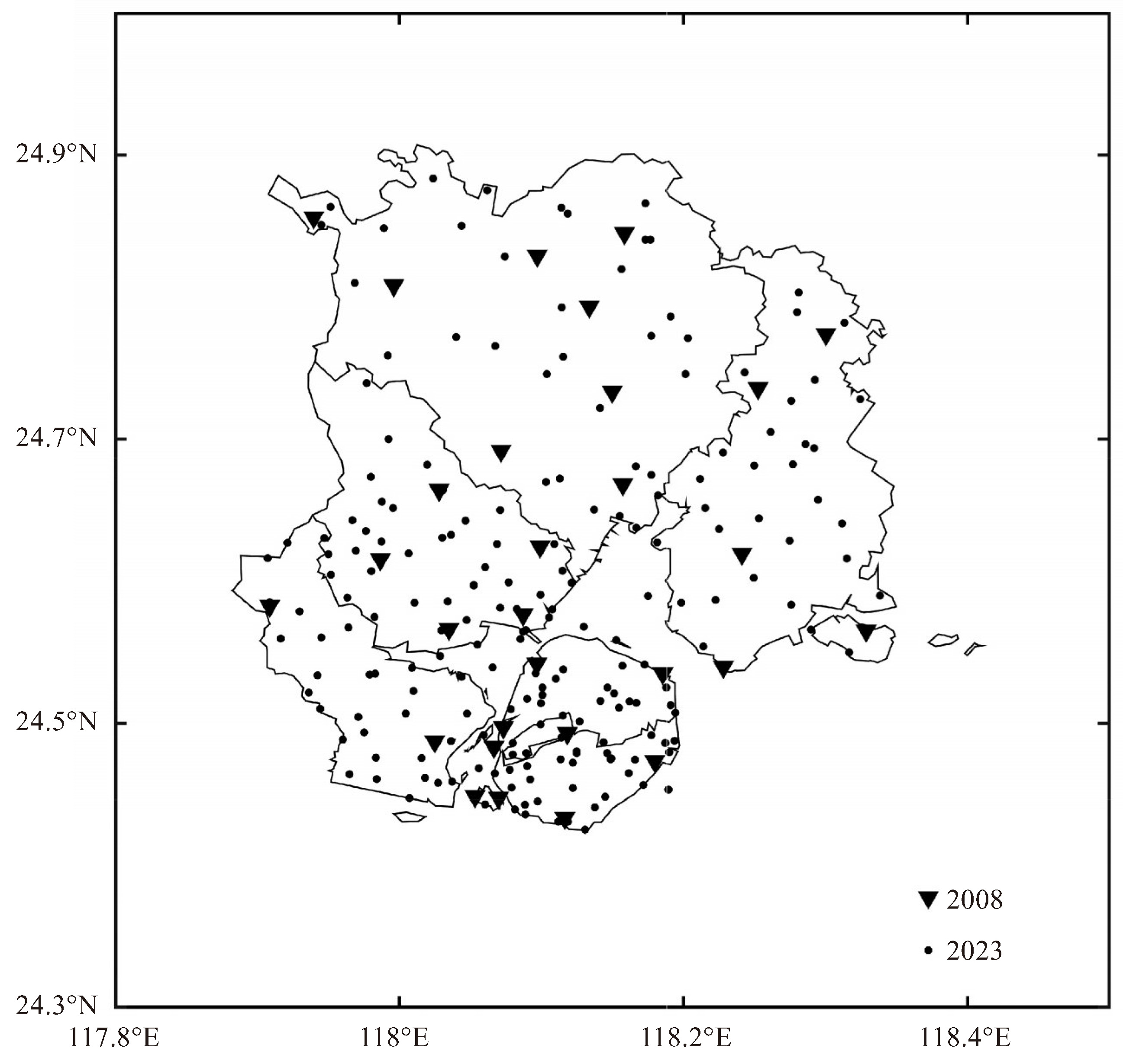
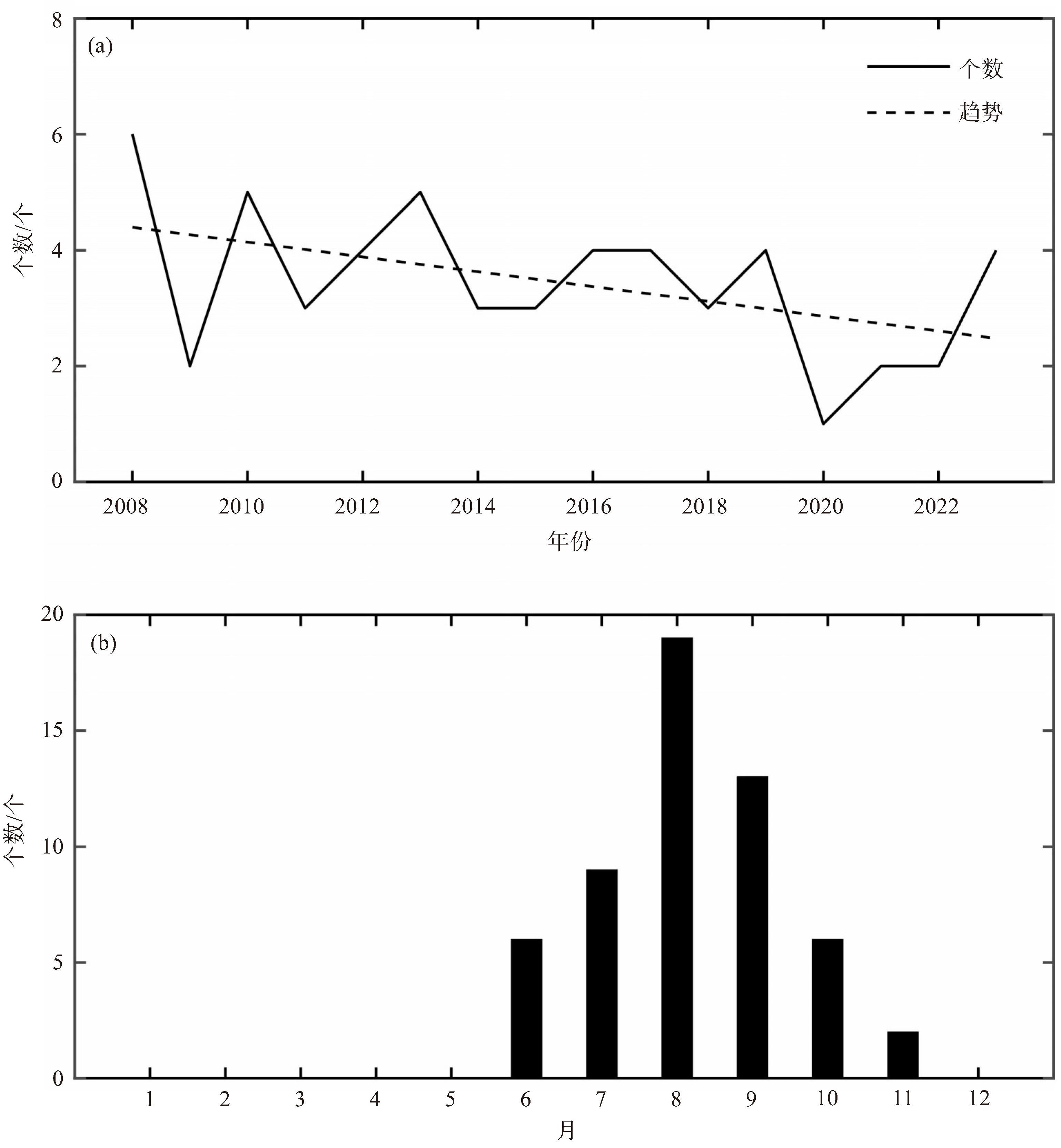
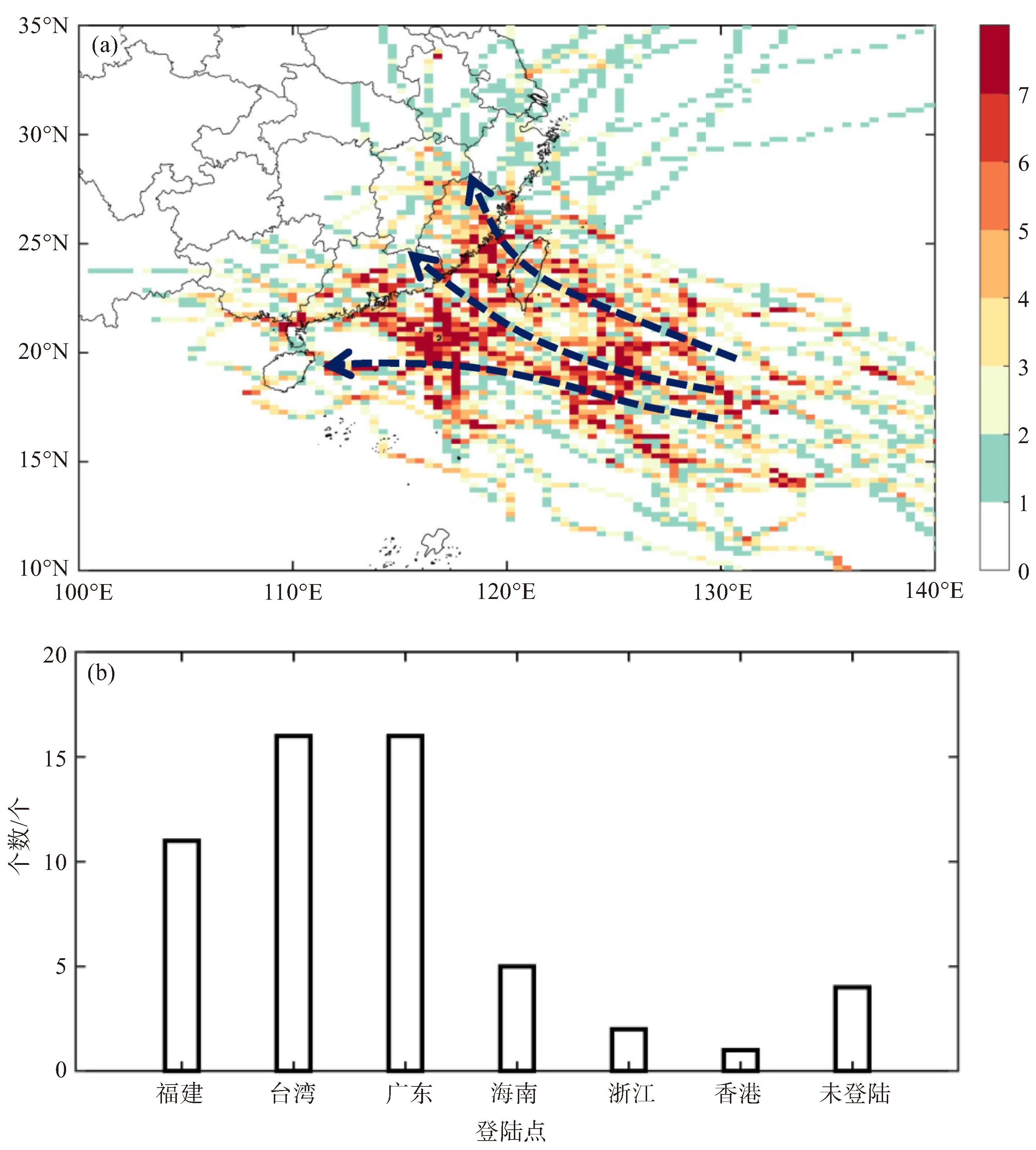
摘要: 利用厦门区域常规气象观测资料以及中国气象局上海台风研究所(CMA-STI)热带气旋最佳路径数据集资料,对2008—2023年影响厦门市的台风统计特征进行系统分析。结果表明:(1)2008—2023年影响厦门市的台风共计55个,年均3.4个,主要集中在7—9月。其中,78%的影响台风在福建、台湾和广东登陆。(2)当台风中心距离厦门市300 km以内时,降水和大风主要是由台风本体云系造成,台风位于厦门市西侧时更易产生短时强降水;且台风中心离厦门市越近,自身强度越强,所引发的风力越强。当台风中心距离厦门300~600 km时,若台风处于西北象限,产生局地性短时强降水的概率达到10.9%;引起大风的台风位于厦门市南侧海面,特别是在秋季和冷空气共同影响下,有利于大风强度加强。(3)大部分影响台风造成的降水空间分布都较不均匀,强降水过程影响持续1天左右,且超75%以上的台风伴随短时强降水天气。半数影响台风能造成8级及以上平均风和10级及以上阵风;大部分台风带来的强风持续时间较短,风力影响范围较小且影响较为集中。降水影响和大风影响之间相关性不高,对厦门市产生较高影响的台风多数以降水影响为主。Abstract: Based on the routine meteorological observation data in the Xiamen region and the China Meteorological Administration-Shanghai Typhoon Institute (CMA-STI) tropical cyclone best path dataset, this study systematically analyzes the statistical characteristics of typhoons affecting Xiamen from 2008 to 2023. The results show that: (1) There were a total of 55 typhoons affecting Xiamen from 2008 to 2023, with an annual average of 3.4, mainly concentrated from July to September. 78% of these typhoons made landfall in Fujian, Taiwan, and Guangdong. (2) Within a range of 300 km from Xiamen, precipitation and strong winds are primarily induced by their intrinsic effects. Typhoons positioned west of Xiamen exhibit a significantly higher propensity to trigger short-duration heavy precipitation. The closer a typhoon was to Xiamen and the greater its intensity, the stronger the wind it induced. Within the range of 300~600 km, there was a 10.9% probability of generating localized short-duration heavy rainfall when the typhoon was in the northwest quadrant. Typhoons to the south of Xiamen, particularly in autumn and when interacting with cold air, were more conducive to stronger winds. (3) Most of the precipitation caused by typhoons was unevenly distributed, with the strongest impact lasting for about a day and over 75% of typhoons accompanied by short-term heavy rainfall weather. Half of the typhoons could cause average winds of level 8 or above, gusts of level 10 or above, and most typhoons had short duration strong winds with limited impact and concentrated effects. The correlation between precipitation and strong winds remains weak, indicating that most high-impact typhoons affecting Xiamen are mainly affected by precipitation.
-
Key words:
- phoon /
- intensity of rainfall and strong gale /
- statistical analysis
-

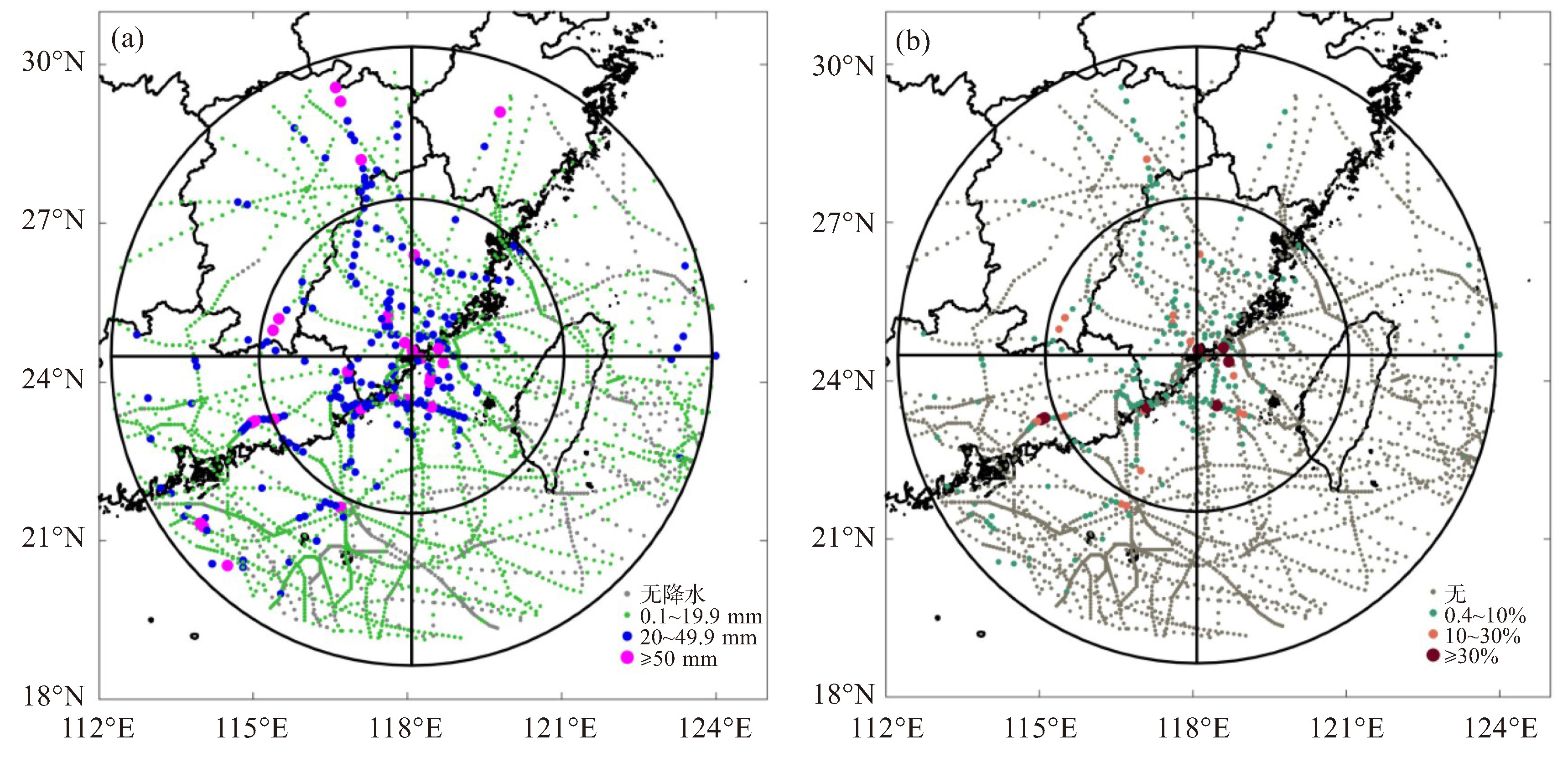
图 5 距离厦门600 km范围内在该台风位置时刻厦门区域内所有观测站点的小时雨强极值(a);出现20 mm以上小时雨强的观测站占比(b)(一圈代表距离厦门站300 km)

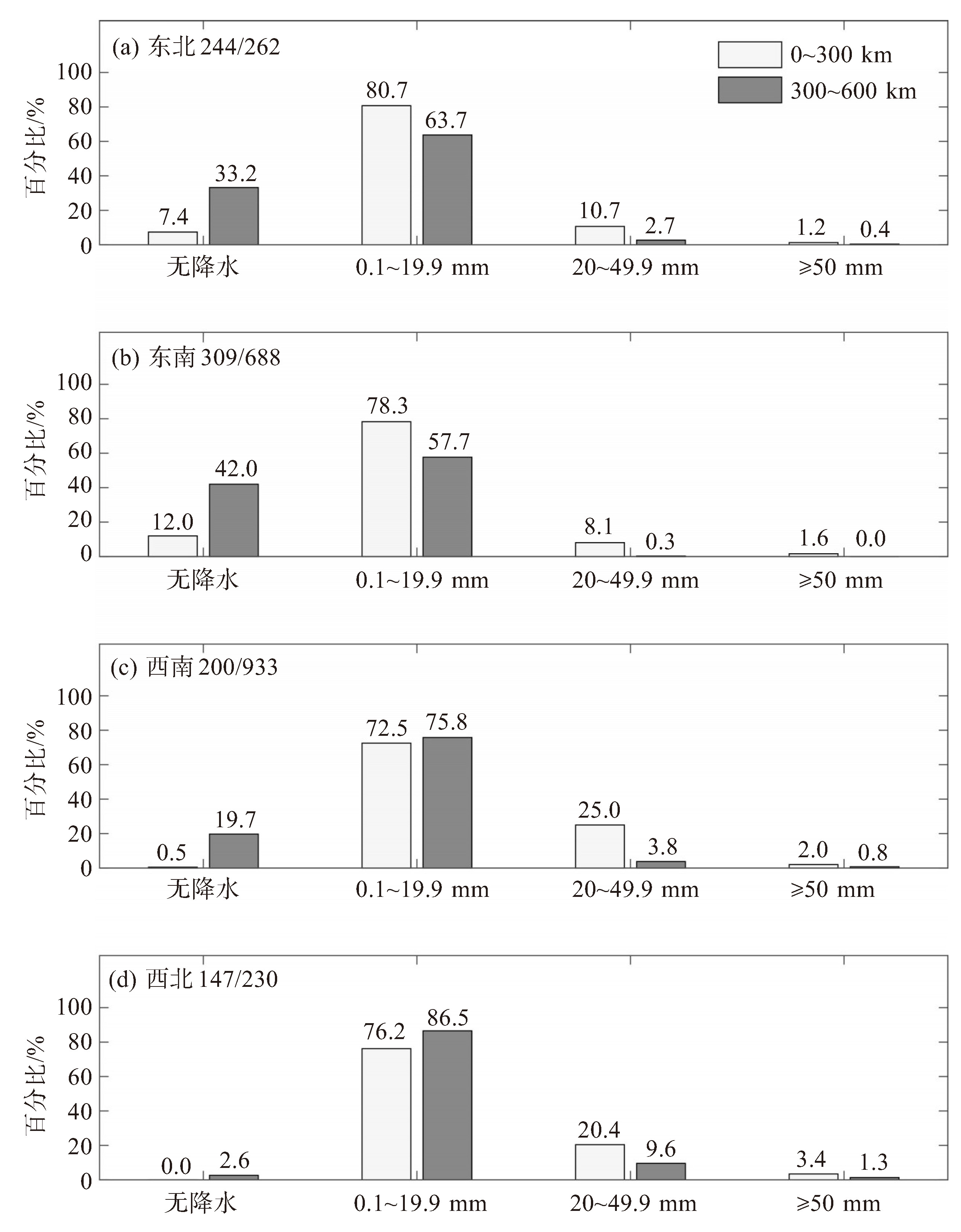
图 6 台风处于0~300 km、300~600 km范围内东北(a)、东南(b)、西南(c)、西北(d)象限厦门区域内所有观测站点无降水、小时雨强极值在0.1~19.9 mm、20~49.9 mm、50 mm及以上时所占百分比
台风1 h的位置算1个样本,象限后面的数字分别代表台风在该象限0~300 km、300~600 km总的样本数。

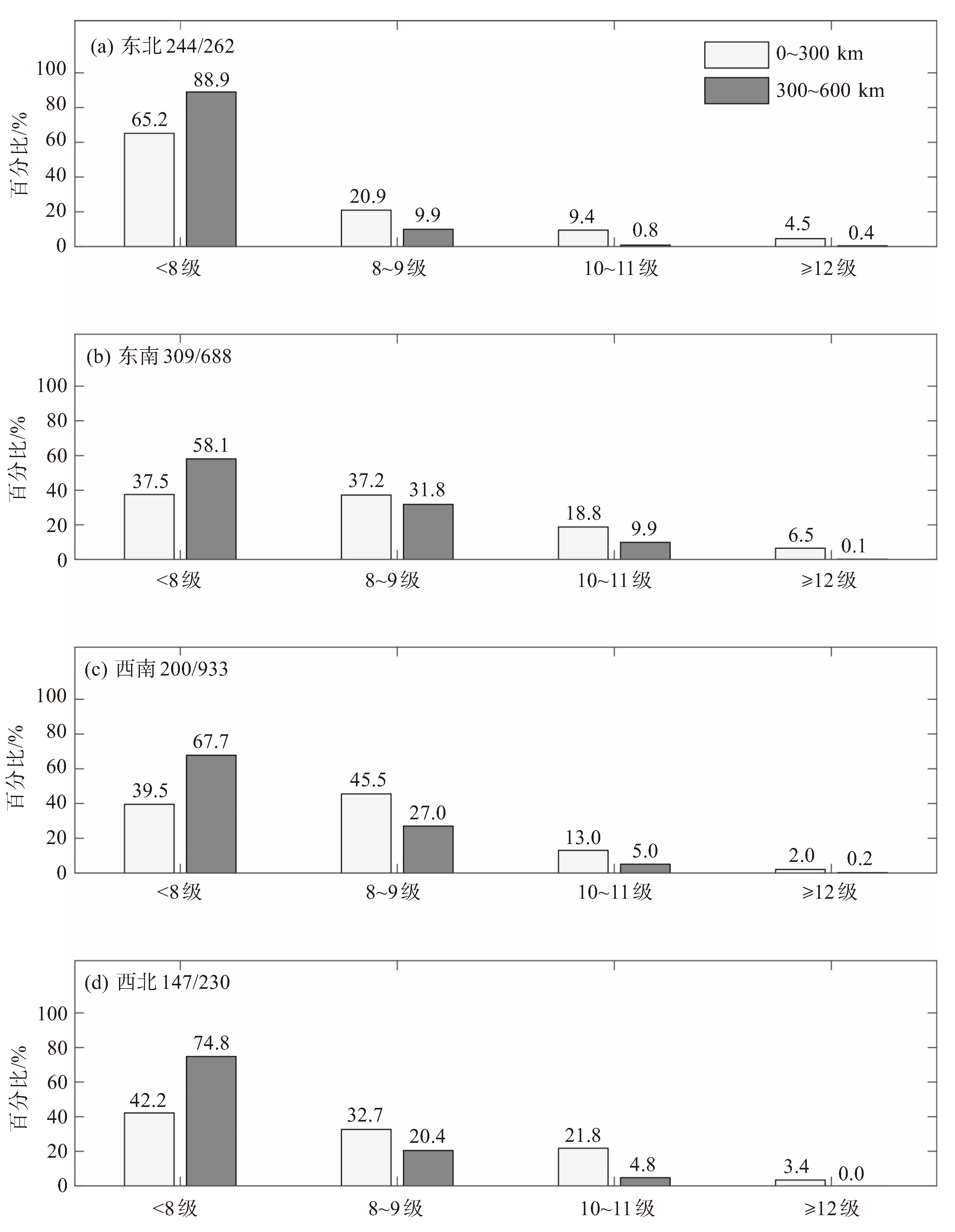
图 8 台风处于0~300 km、300~600 km范围内东北(a)、东南(b)、西南(c)、西北(d)象限厦门区域内所有观测站点阵风最大等级为8级以下、8~9级、10~11级、12级及以上时所占的百分比
台风1 h的位置算1个样本,象限后面的数字分别代表台风在该象限0~300 km、300~600 km总的样本数。

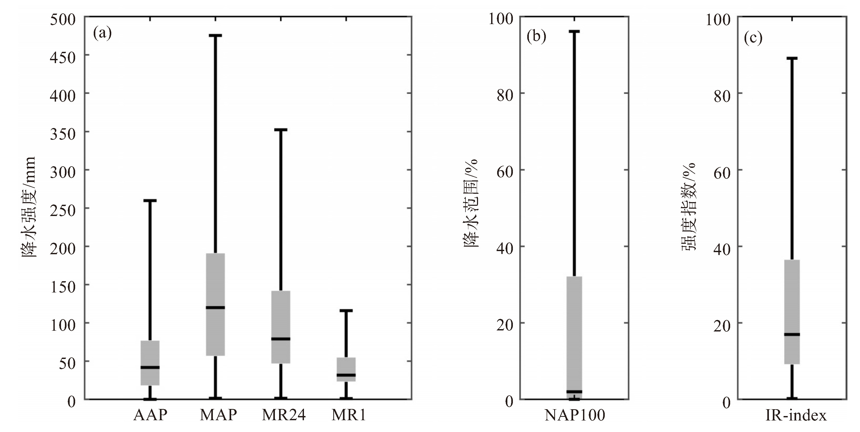
图 9 过程平均累计雨量(AAP)、过程最大累计雨量(MAP)、过程最大日雨量(MR24)、过程最大小时雨强(MR1)(a);过程最大累计雨量超过100 mm的站数占比(NAP100)(b);降水强度指数(c)的箱线图

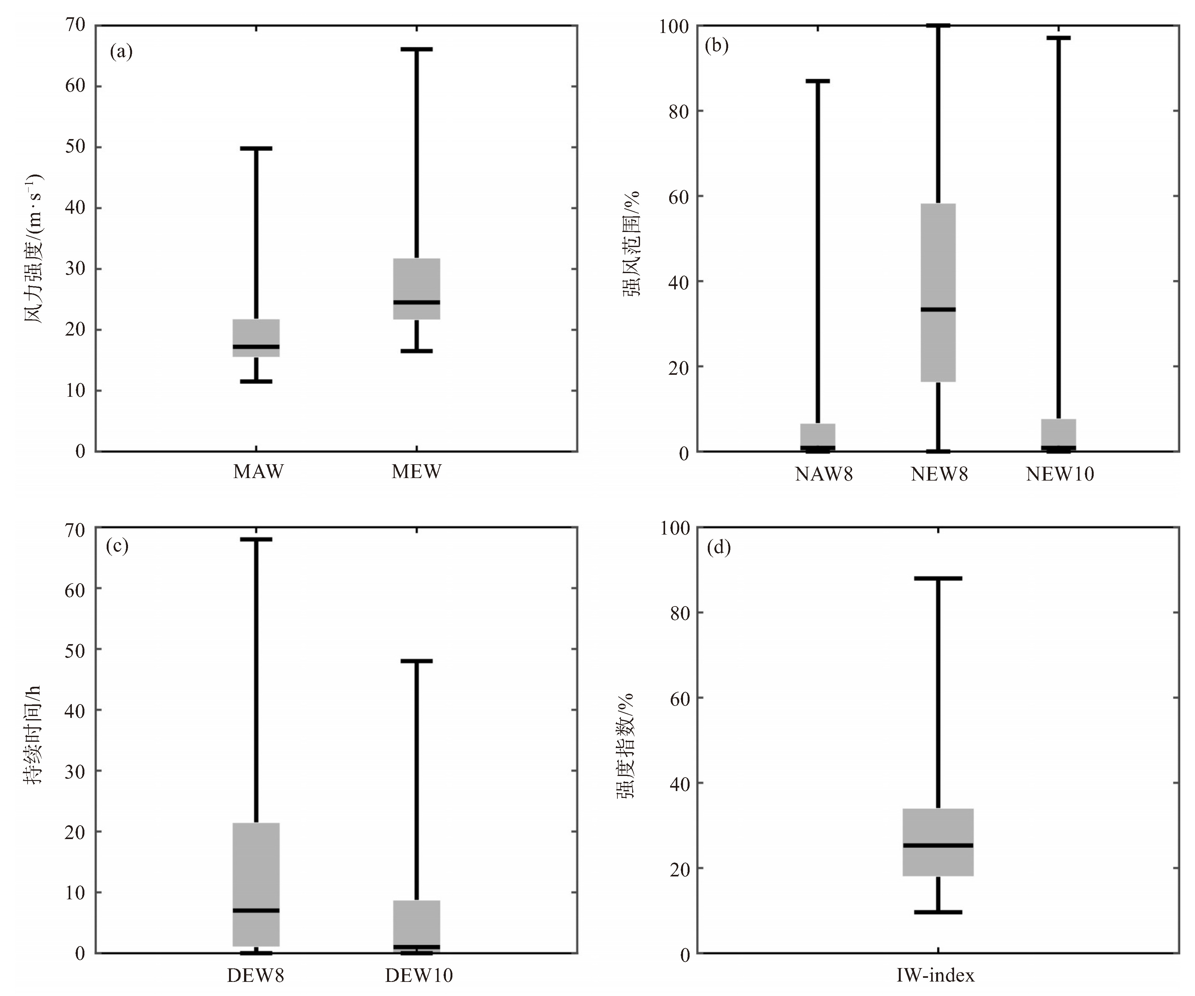
图 10 过程最大平均风(MAW)、过程最大阵风(MEW)(a);8级及以上平均风站数占比(NAW8)、8级及以上阵风站数占比(NEW8)、10级及以上阵风站数占比(NEW10)(b);8级及以上阵风持续时间(DEW8)、10级及以上阵风持续时间(DEW10)(c);大风强度指数(d)的箱线图
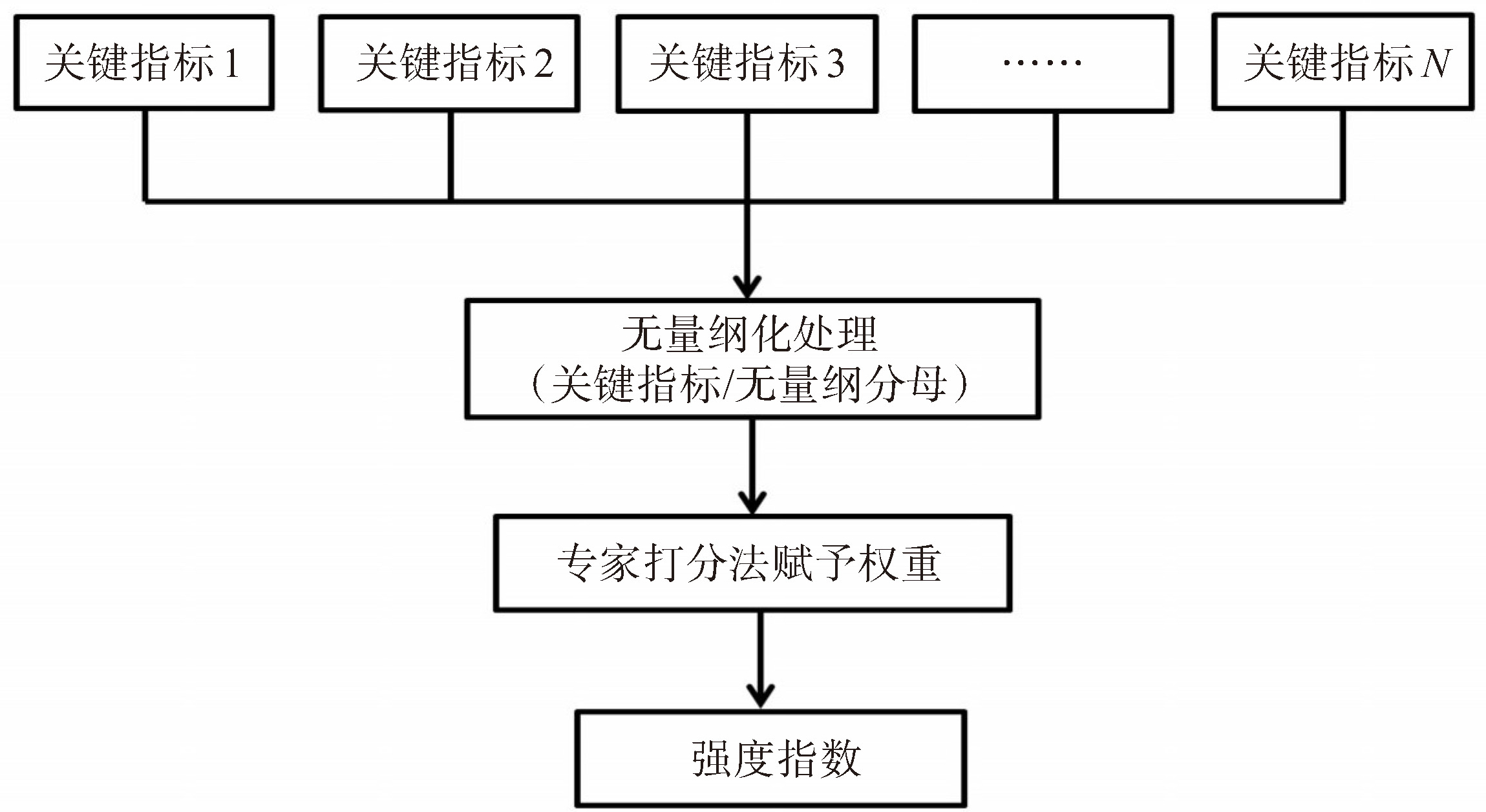
表 1 影响台风风雨强度的关键指标及权重分布
影响种类 关键指标 权重 降水影响 过程平均累计雨量AAP(Averaged Accumulated Precipitation, AAP) 0.25 过程最大累计雨量MAP(Max Accumulated Precipitation, MAP) 0.2 过程最大日雨量MR24(Max Rainfall during 24 h, MR24) 0.15 过程最大小时雨强MR1(Max Rainfall during 1 h, MR1) 0.1 过程最大累计雨量超过100 mm的站数NAP100(Numbers of Stations with Accumulated Precipitation greater than 100 mm, NAP100) 0.3 大风影响 过程最大平均风MAW(Max Averaged Wind, MAW) 0.2 过程最大阵风MEW(Max Extreme Wind, MEW) 0.2 8级及以上阵风持续时间DEW8(Duration with Extreme Wind greater than 8 level, DEW8) 0.1 10级及以上阵风持续时间DEW10(Duration with Extreme Wind greater than 10 level, DEW10) 0.1 8级及以上平均风站数NAW8(Numbers of Stations with Averaged Wind greater than 8 level, NAW8) 0.1 8级及以上阵风站数NEW8(Numbers of Stations with Extreme Wind greater than 8 level, NEW8) 0.2 10级及以上阵风站数NEW10(Numbers of Stations with Extreme Wind greater than 10 level, NEW10) 0.1  下载: 导出CSV
-
[1] 于玉斌, 陈联寿, 杨昌贤. 超强台风"桑美"(2006)近海急剧增强特征及机理分析[J]. 大气科学, 2008, 32(2): 405-416. [2] 郑艳, 蔡亲波, 程守长, 等. 超强台风"威马逊"(1409)强度和降水特征及其近海急剧加强原因[J]. 暴雨灾害, 2014, 33(4): 333-341. [3] 崔梦雪, 向纯怡, 张晗昀, 等. 台风"杜苏芮"(2305)引发福建极端强降水的特征分析[J]. 海洋气象学报, 2023, 43(4): 11-20. [4] 吴幸毓, 高珊, 韩美, 等. 影响福建的早台风统计特征[J]. 应用海洋学学报, 2020, 39(4): 453-459. [5] 高建芸, 江志红, 游立军, 等. 百余年来影响福建热带气旋的变化特征[J]. 应用气象学报, 2007, 18(2): 211-218. [6] Nayak S, Takemi T. Statistical analysis of the characteristics of typhoons approaching Japan from 2006 to 2019[J]. Geomatics, Natural Hazards and Risk, 2023, 14(1): 2208722. [7] 金荣花, 高拴柱, 顾华, 等. 近31年登陆北上台风特征及其成因分析[J]. 气象, 2006, 32(7): 33-39. [8] 杨玉华, 雷小途. 我国登陆台风引起的大风分布特征的初步分析[J]. 热带气象学报, 2004, 20(6): 633-642. [9] 毛绍荣, 张东, 梁健, 等. 广东近海台风路径异常的统计特征[J]. 应用气象学报, 2003, 14(3): 348-355. [10] 邢蕊, 徐晶, 林瀚. 热带气旋过台湾后再次登陆的路径强度变化统计分析[J]. 气象, 2020, 46(4): 517-527. [11] 郑峰, 曾智华, 雷小途, 等. 中国近海突然增强台风统计分析[J]. 高原气象, 2016, 35(1): 198-210. [12] 徐威, 周顺武, 葛旭阳, 等. 西北太平洋热带气旋快速增强阶段的风速分布特征[J]. 热带气象学报, 2017, 33(2): 259-266. [13] 陈联寿, 丁一汇. 西太平洋台风概论[M]. 北京: 科学出版社, 1979. [14] 王咏梅, 任福民, 李维京, 等. 中国台风降水的气候特征[J]. 热带气象学报, 2008, 24(3): 233-238. [15] 陆桂荣, 王文, 郑美琴, 等. 海南台风暴雨的时空分布特征[J]. 大气科学学报, 2015, 38(5): 710-715. [16] 陆逸, 朱伟军, 任福民, 等. 1980—2014年中国台风大风和台风极端大风的变化[J]. 气候变化研究进展, 2016, 12(5): 413-421. [17] 刘婧茹, 李英, 孟青, 等. 中国东南地区热带气旋大风及其伴随天气的统计特征[J]. 大气科学, 2023, 47(4): 1024-1038. [18] 尹烈, 郑秀云, 王晓芙, 等. 登陆粤东台风对厦门天气影响成因的特征分析[J]. 气象研究与应用, 2015, 36(S1): 57-59. [19] 陈德花, 张玲, 张伟, 等. "莫兰蒂"台风致灾大风的结构特征及成因[J]. 大气科学学报, 2018, 41(5): 692-701. [20] 荀爱萍, 吕巧谊, 黄昕, 等. 2006号台风"米克拉"近海急剧增强诊断分析[J]. 热带气象学报, 2023, 39(3): 337-347. [21] Ying M, Zhang W, Yu H, et al. An overview of the China meteorological administration tropical cyclone database[J]. Journal of Atmospheric and Oceanic Technology, 2014, 31(2): 287-301. [22] Lu X Q, Yu H, Ying M, et al. Western north Pacific tropical cyclone database created by the China meteorological administration[J]. Advances in Atmospheric Sciences, 2021, 38(4): 690-699. [23] 陈香. 福建省台风灾害风险评估与区划[J]. 生态学杂志, 2007, 26(6): 961-966. [24] Lu Y, Ren F M, Zhu W J. Risk zoning of typhoon disasters in Zhejiang Province, China[J]. Natural Hazards and Earth System Sciences, 2018, 18(11): 2921-2932. [25] 刘青, 王军, 许瀚卿, 等. 台风影响下沿海城市风雨复合灾害风险研究——以海口市为例[J]. 灾害学, 2022, 37(4): 129-134. [26] 陈言照, 华晓白, 华桃春. 近10年罗源湾台风风雨综合影响指数分析[J]. 农业灾害研究, 2024, 14(1): 191-193. [27] 力梅, 郑群峰, 兰红平, 等. 一种台风风雨综合影响指数计算方法及存储装置: CN111191936B[P]. 2020. -

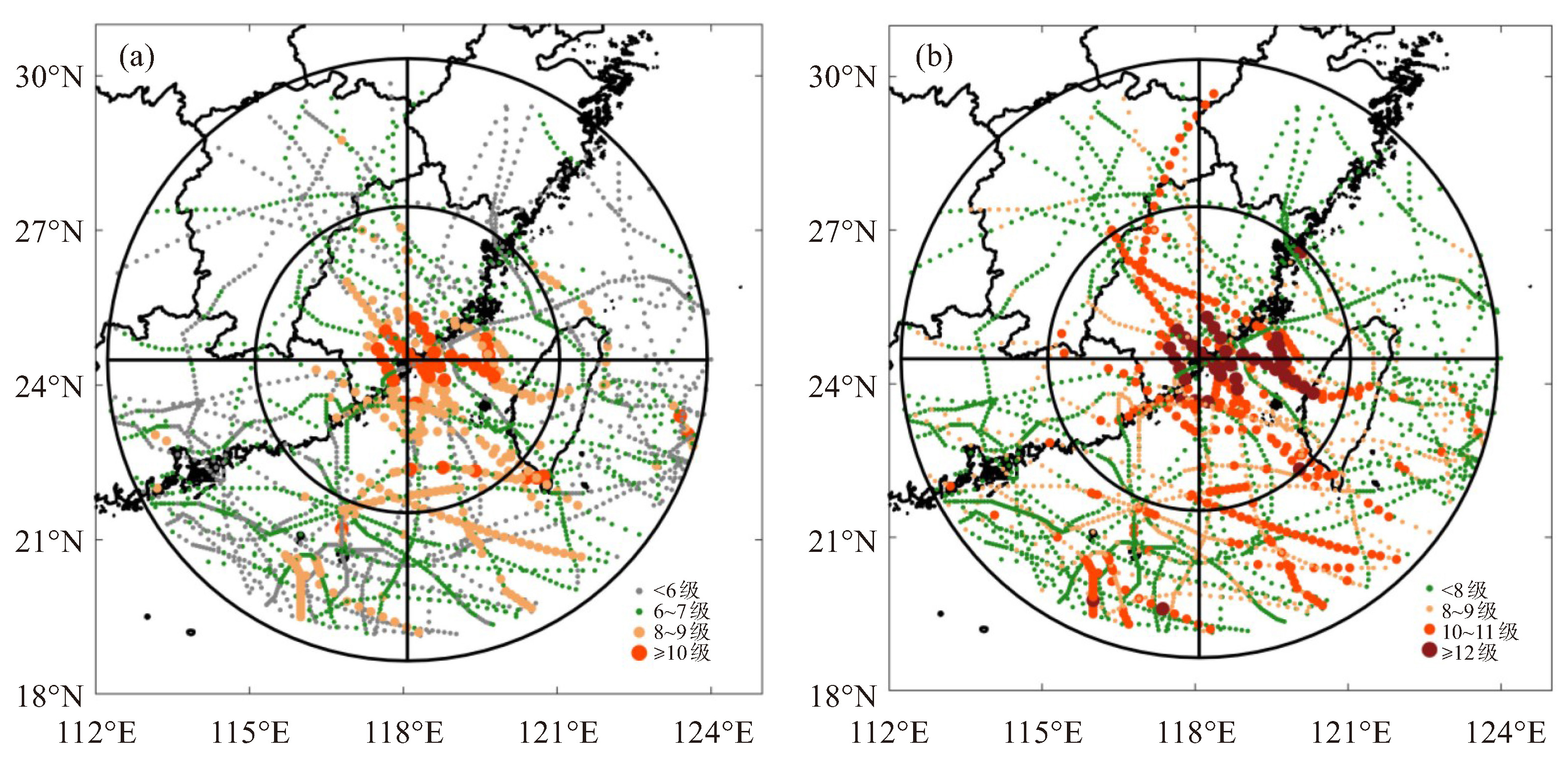
 点击查看大图
计量
- 文章访问数: 2
- HTML全文浏览量: 1
- PDF下载量: 0
- 被引次数: 0
 粤公网安备 4401069904700003号