


The Causes and Detailed Structural Characteristics of A Catastrophic Tornado in Guangzhou in 2024
-
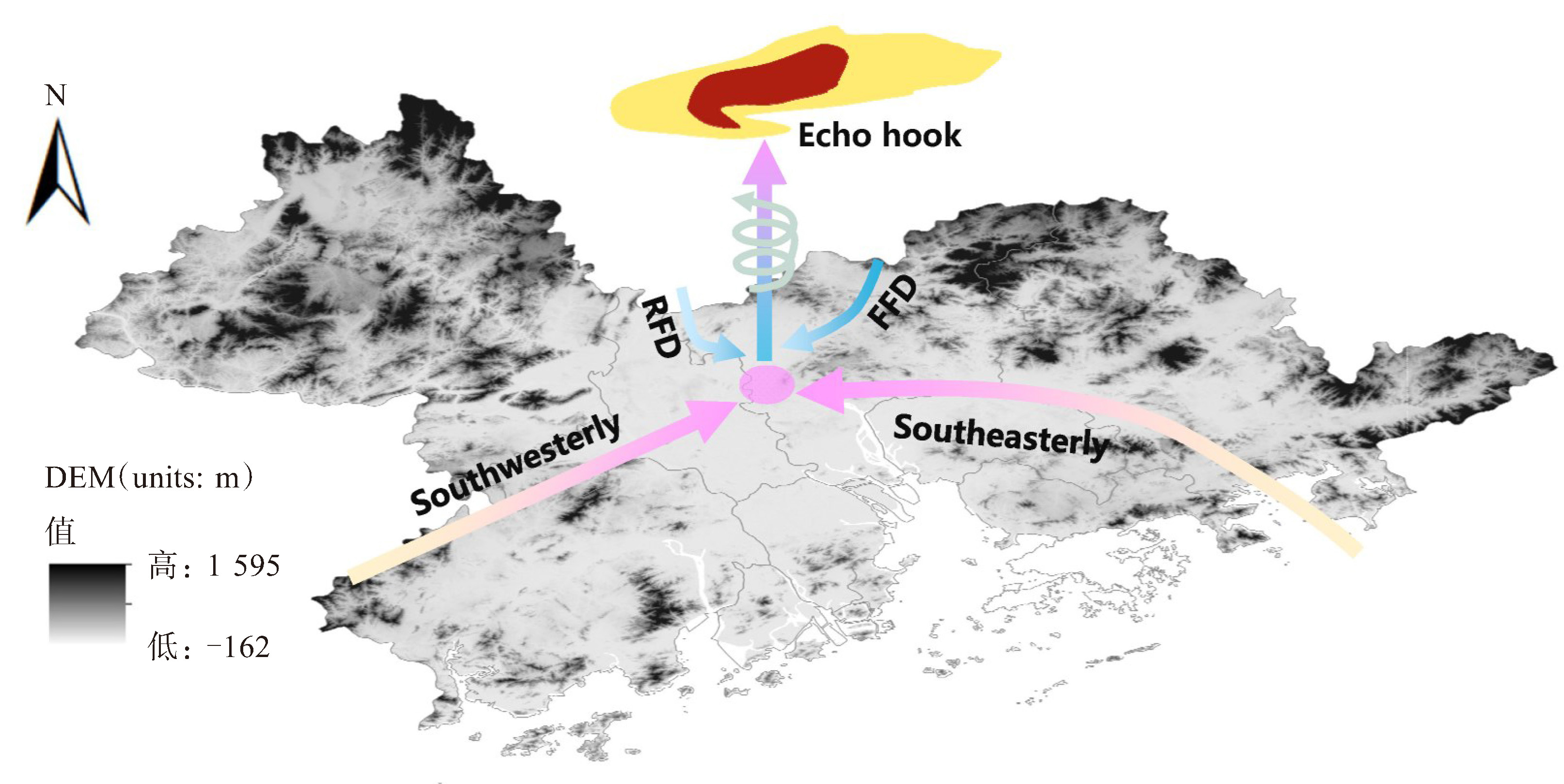
摘要: 为加强对龙卷触发机理及精细结构特征的认识,利用S波段双偏振雷达(CINRAD/SAD)、X波段相控阵双偏振雷达(XPAR)、风廓线雷达、ERA5再分析资料、探空和地面加密自动气象站等多源观测资料,分析了2024年4月27日发生在广州的EF2级龙卷的成因及龙卷母体不同发展阶段的中尺度环境场和不同类型雷达特征差异,结果表明:(1)龙卷母体风暴由高层辐散、中高层干冷空气侵入、低层偏南暖湿气流和地面低压槽东南风上岸的辐合线共同影响所致;3 571.0 J·kg-1高对流有效位能(CAPE)、277.2 m低抬升凝结高度(LCL)和25.1 m·s-1大的0~6 km垂直风切变(SHR6)有利于超级单体风暴生成,在龙卷发生前0~1 km垂直风切变(SHR1)迅速增大至25.5 m·s-1,创造了龙卷触发的低层涡旋条件。(2)风暴单体沿地面西北风和东北风切变辐合线方向发展移动,当切变线与偏南和东南暖湿气流相遇时,低层入流缺口演变为钩状回波,风暴单体发展为超级单体;在龙卷触发前,超级单体中气旋的强度加强,其径向和切向直径迅速收缩,厚度增加,TVS最大旋转速度增至最大的26 m·s-1,最大旋转速度高度逐渐向下发展,最低为1.2 km,当钩状回波与地面切变辐合线和正相对涡度区重叠时,龙卷触发。(3)龙卷发生在超级单体钩状回波中,未触发时,超级单体大冰雹特征明显,而在龙卷触发时,超级单体冰雹生长明显减弱;可观测到龙卷涡旋特征(TVS)与下沉反射率因子核心(DRC)位置重叠且接地,并位于表征强上升气流通道的有界弱回波区(BWER)左侧,TVS位置出现表征雨滴和地面碎屑被龙卷强烈旋转风卷入现象的一条狭长的区别于BWER的CC、ZDR低值柱且与地面TDS区域相连。
-
关键词:
- 龙卷 /
- 环境特征 /
- 精细结构 /
- CINRAD/SAD双偏振雷达 /
- XPAR双偏振雷达
Abstract: On the afternoon of April 27th, 2024, an EF2 rank tornado struck Zhongluotan Town in Baiyun District, Guangzhou City, Guangdong Province, resulting in 5 fatalities, 33 injuries, and substantial economic damage. To enhance the understanding of the mechanisms triggering tornadoes and their detailed structural characteristics, this study integrated multi-source observational data, including S-band dualpolarization radar (CINRAD/SAD), X-band phased-array dual-polarization radar (XPAR), wind profiler radar, ERA5 reanalysis data, sounding data, and dense surface automatic meteorological station data, to analyze the genesis of the tornado, the mesoscale environmental fields and the radar characteristics at different developmental stages of the tornado parent storm. The results are as follows: (1) The parent storm of the tornado was influenced by upper-level divergence, mid-level dry and cold air intrusion, low-level southerly warm and moist airflow, and surface low-pressure trough southeast wind convergence lines. The high convective available potential energy (CAPE) of 3 571.0 J·kg-1, low lifting condensation level (LCL) of 277.2 m, and significant 0-6 km vertical wind shear (SHR6) of 25.1 m·s-1 were conducive to the development of the supercell storm. In the hour preceding tornadogenesis, the 0-1 km vertical wind shear (SHR1) rapidly increased to 25.5 m·s-1, creating low-level vortex conditions which favorable for tornado triggering. (2) The storm cell developed and moved along the direction of the wind convergence line of the surface northwesterly and northeasterly wind shears. Upon encountering the southerly and southeasterly warm and moist airflows, the low-level inflow notch evolved into a hook echo, and the storm cell developed into a supercell storm. Prior to tornadogenesis, the intensity of the supercell's mesocyclone increased, with rapid contraction of its radial and tangential diameters while its thickness increases. The maximum rotational velocity of the TVS escalates to a peak of 26 m·s-1. The height at which the maximum rotational velocity occurs gradually descends, reaching a minimum altitude of 1.2 km. Tornado occurred when the hook echo overlapped with the ground shear convergence line and the positive relative vorticity area. (3) The tornado occurred within the hook echo of the supercell. Prior to the triggering, the supercell exhibited significant characteristics of large hailstones, which were significantly weakened at the time of tornado triggering. The tornado vortex signature (TVS) and the descending reflectivity core (DRC) were observed to overlap and grounded, positioned to the left of the bounded weak echo region (BWER) that indicative of the intense updraft channel. At the position of the TVS, a narrow column of low CC and ZDR values, distinct from the BWER, appeared and was connected to the ground tornado debris signature (TDS) area, indicating the phenomenon of raindrops and ground debris being entrained by the intense rotating winds of the tornado. -

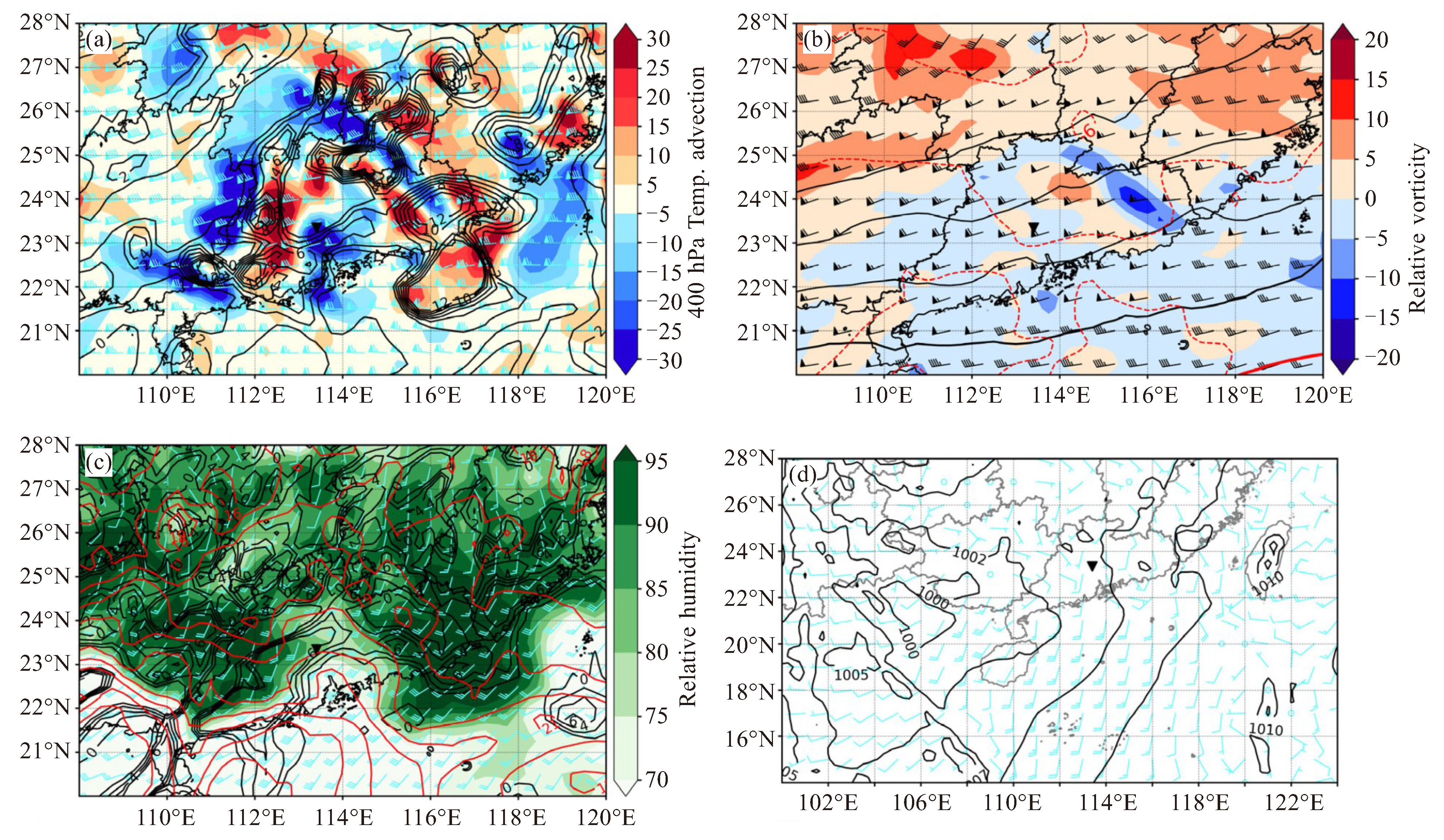
图 2 2024年4月27日14时天气形势:(a)图中黑实线为200 hPa风速辐散(单位:10-5 s-1),填色为400 hPa温度平流(单位:10-5 K·s-1),风羽为200 hPa风场;(b)图中红虚线为500 hPa等温线(单位:℃),黑实线为500 hPa等高线(单位:dagpm),红实线为588 dagpm线,风羽为500 hPa风场,填色为500 hPa涡度;(c)图中红实线为850 hPa等温线(单位:℃),等值线为850 hPa相对涡度(单位:10-5 s-1),填色为850 hPa相对湿度;(d)图中风羽为2 m风场,黑色等值线为平均海平面气压(单位:hPa),倒三角为龙卷发生位置

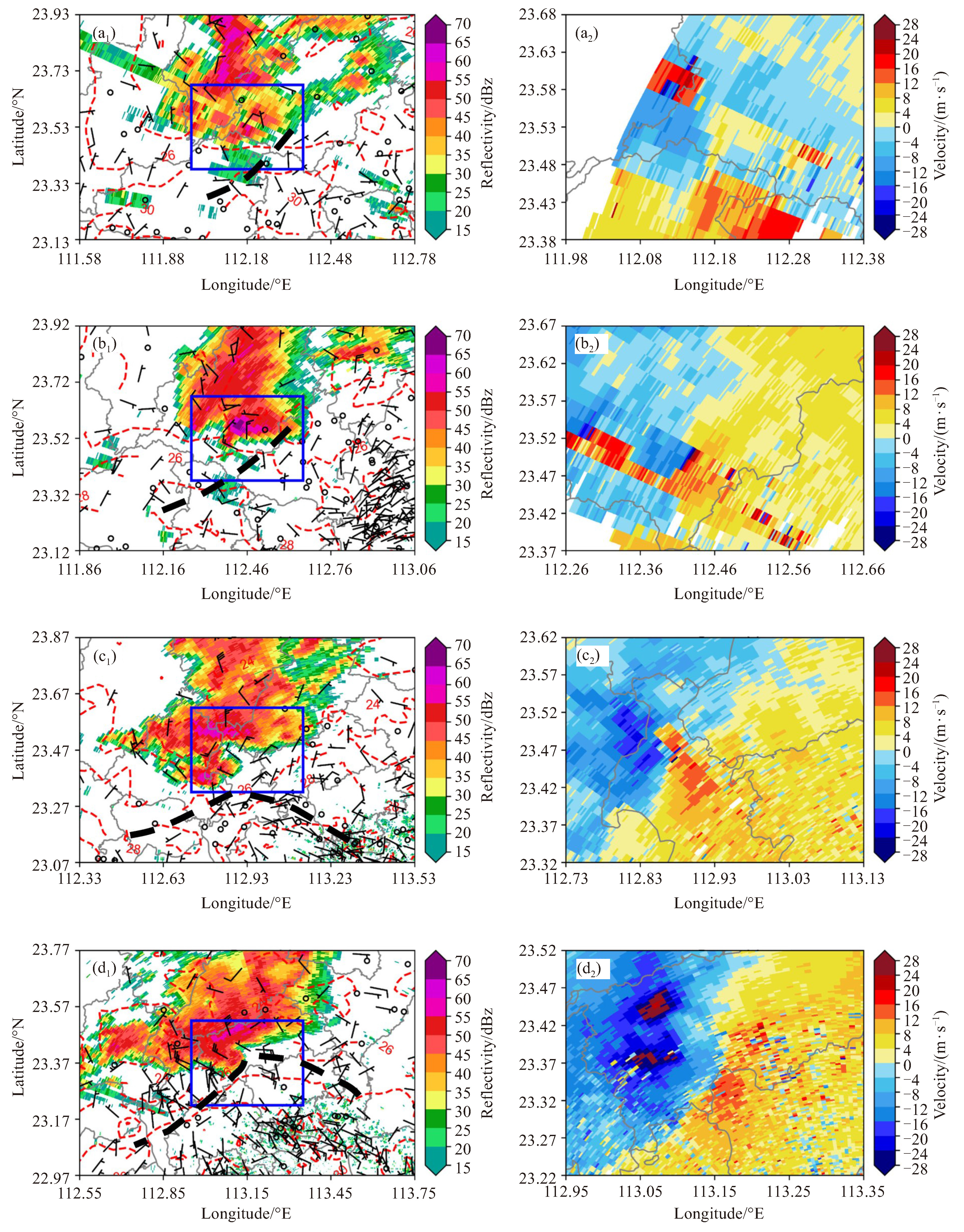
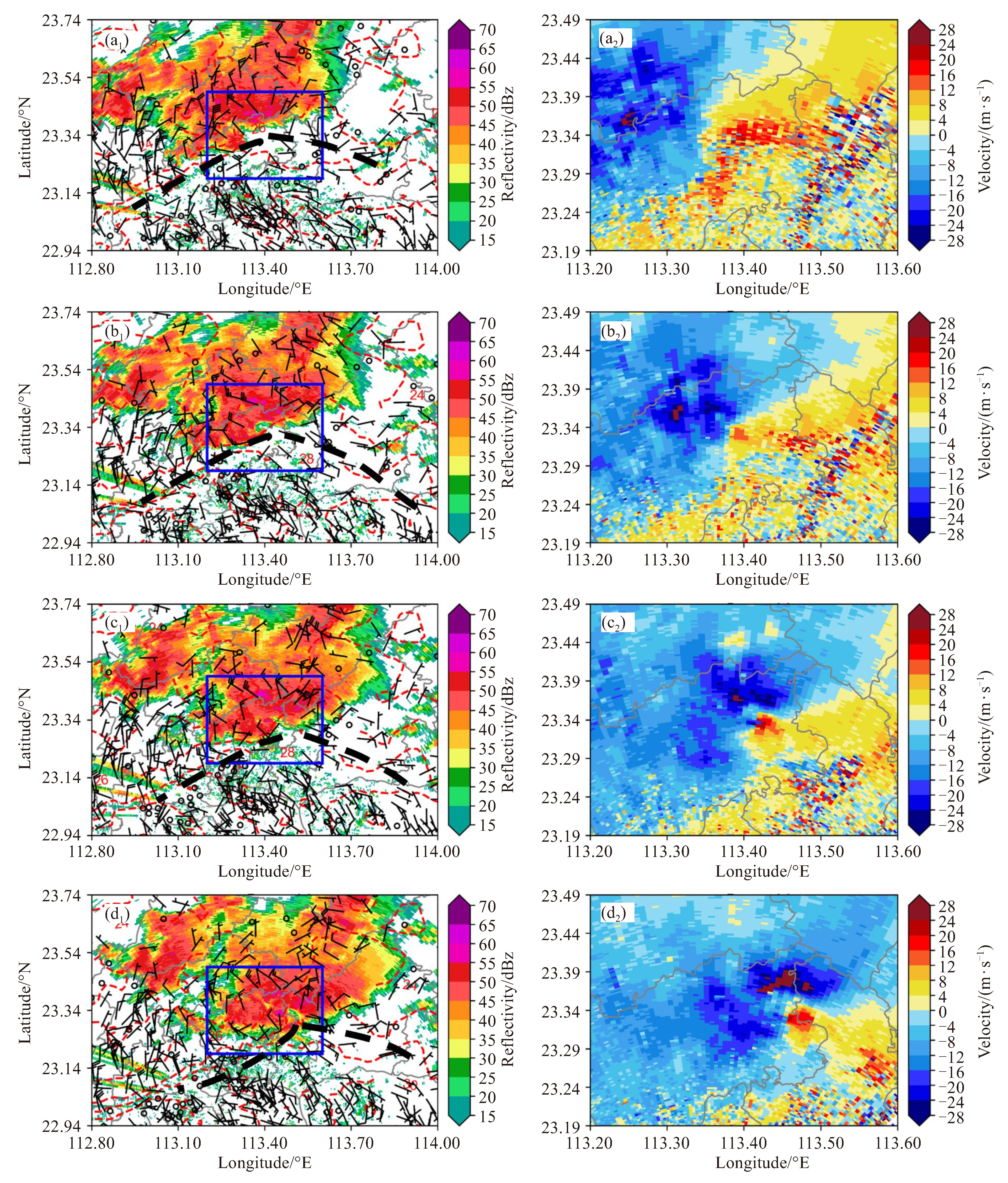
图 4 广州CINRAD/SAD双偏振雷达0.5 °仰角反射率因子、地面自动站2 min平均风向风速(单位:m·s-1)、温度(红色虚线, 单位:℃)(a1:12:30,b1:13:00,c1:13:48,d1:14:18)及对应时间0.5 °仰角径向速度(a2,b2,c2,d2)
a1、b1、c1、d1中蓝色矩形为a2,b2,c2,d2绘图范围;黑色虚线为辐合线。

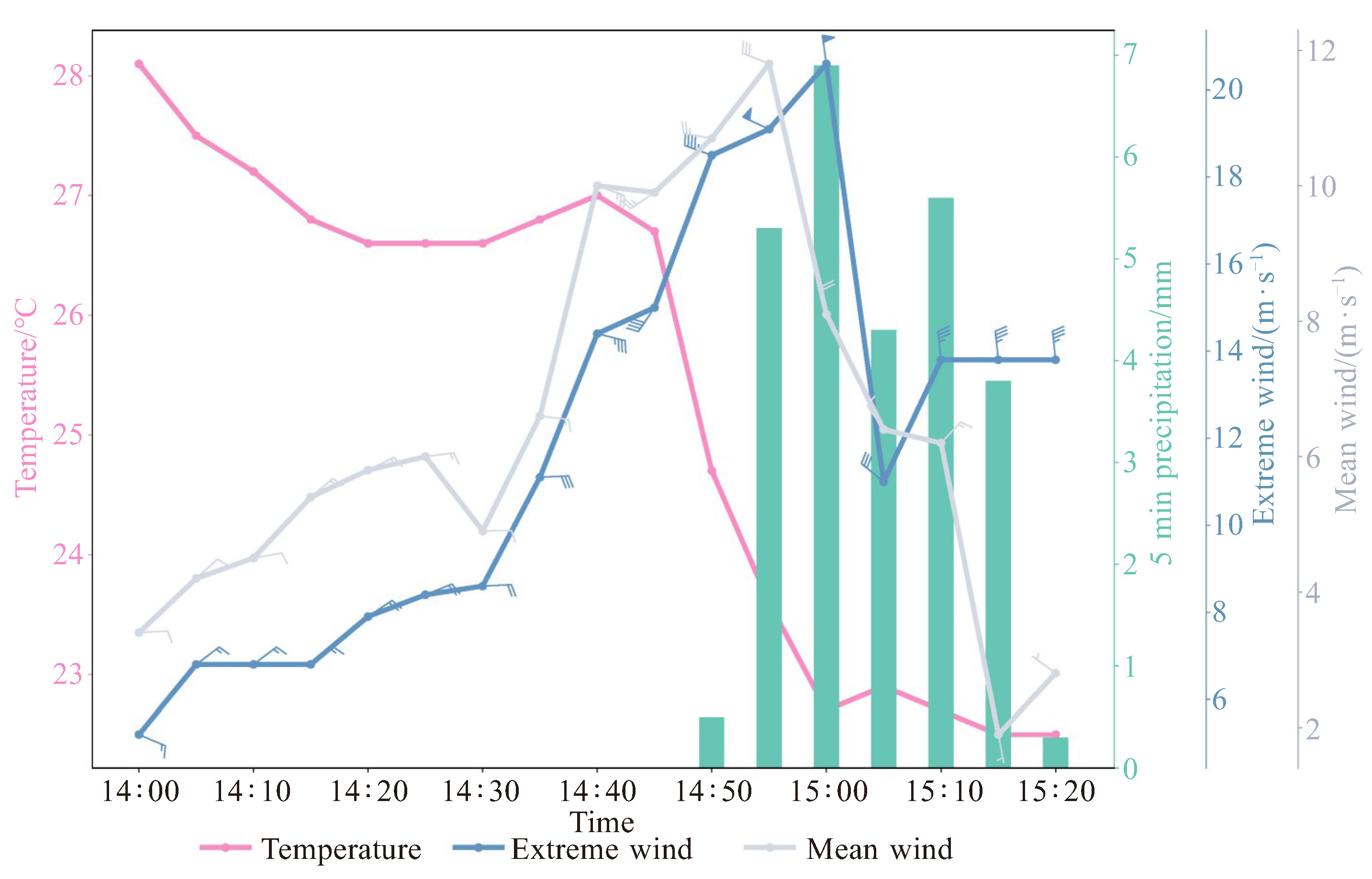
图 6 2024年4月27日14:00—15:20广州市白云区钟落潭镇良田村气象观测站2 min平均气温(粉红色实线,单位:℃)、2 min平均水平风(灰实线,单位:m·s-1)、极大风(蓝实线,单位:m·s-1)、5 min累计降雨量(绿柱,单位:mm)

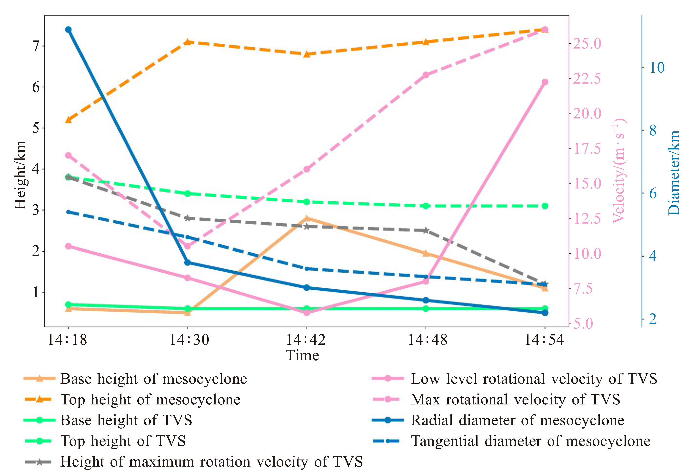
图 7 基于广州CINRAD/SAD双偏振雷达的Rose2.0软件中气旋与TVS识别产品,包括中气旋底高、顶高、径向和切向直径,以及TVS底高、顶高、最大旋转速度及对应高度和低层旋转速度

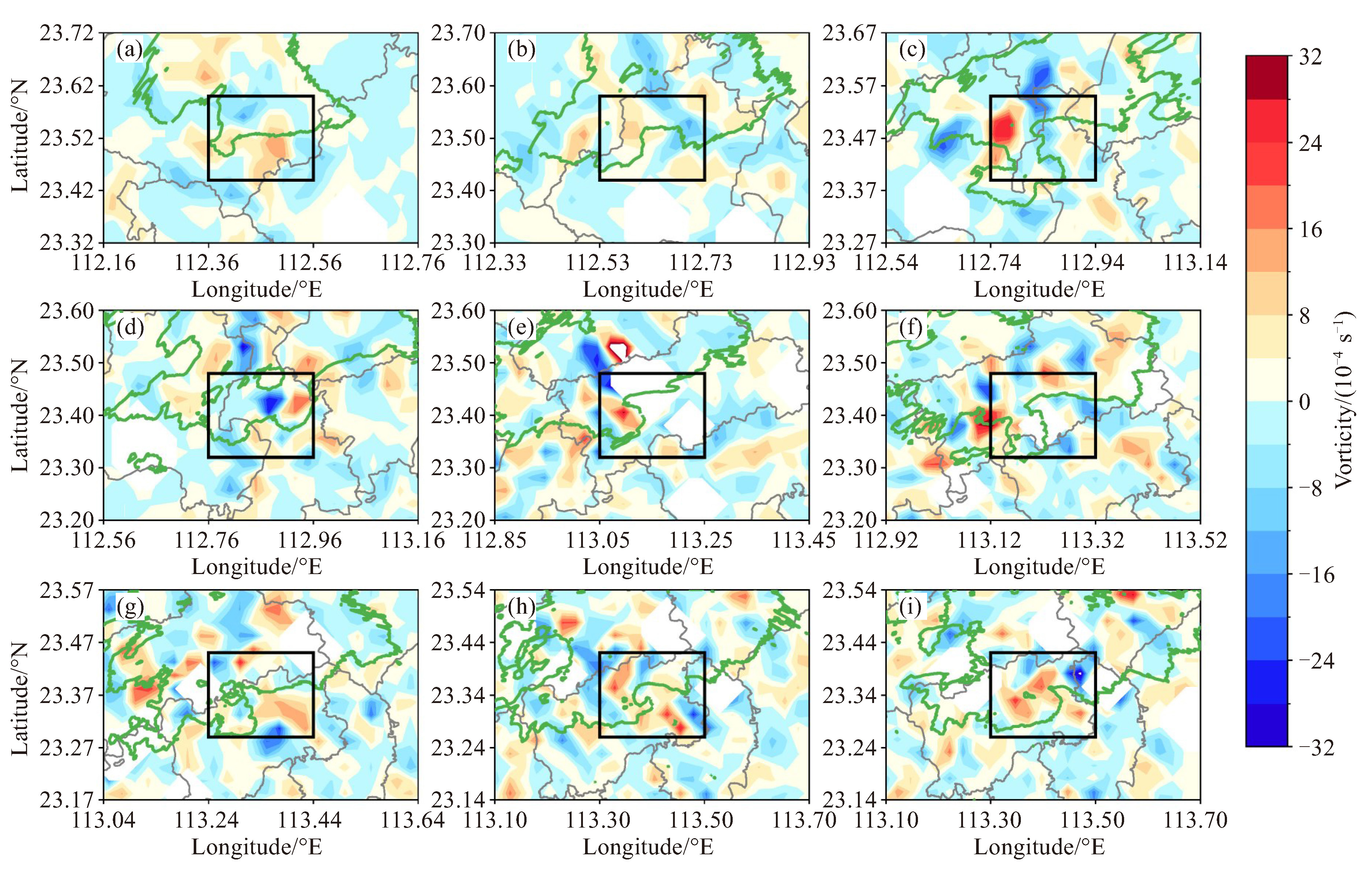
图 8 广州CINRAD/SAD双偏振雷达0.5 °仰角40 dBz反射率因子(绿色等值线)与地面2 min平均相对涡度(填色)
(a:13:00,b:13:24,c:13:48,d:14:00,e:14:18,f:14:30,g:14:42,h:14:48,i:14:54)

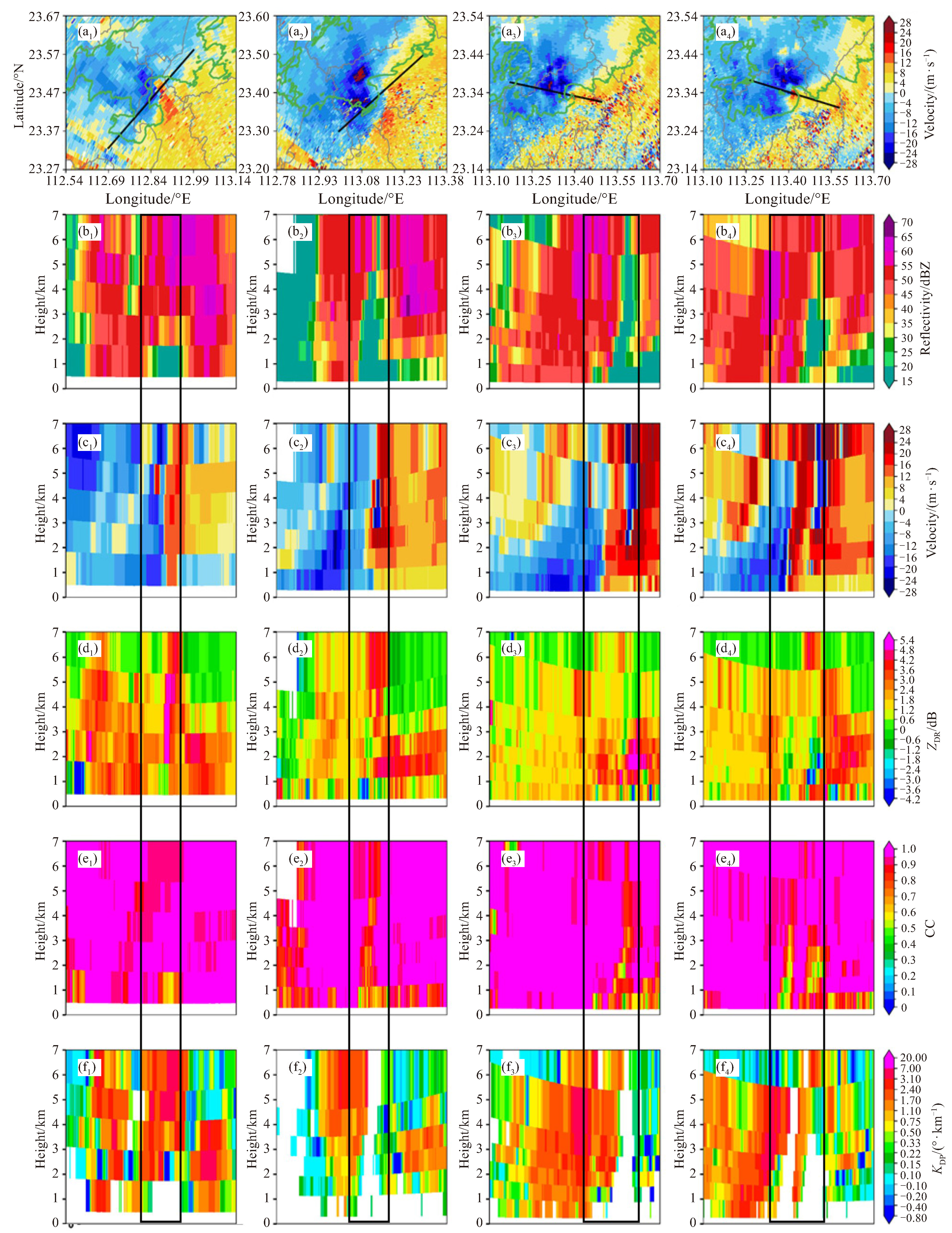
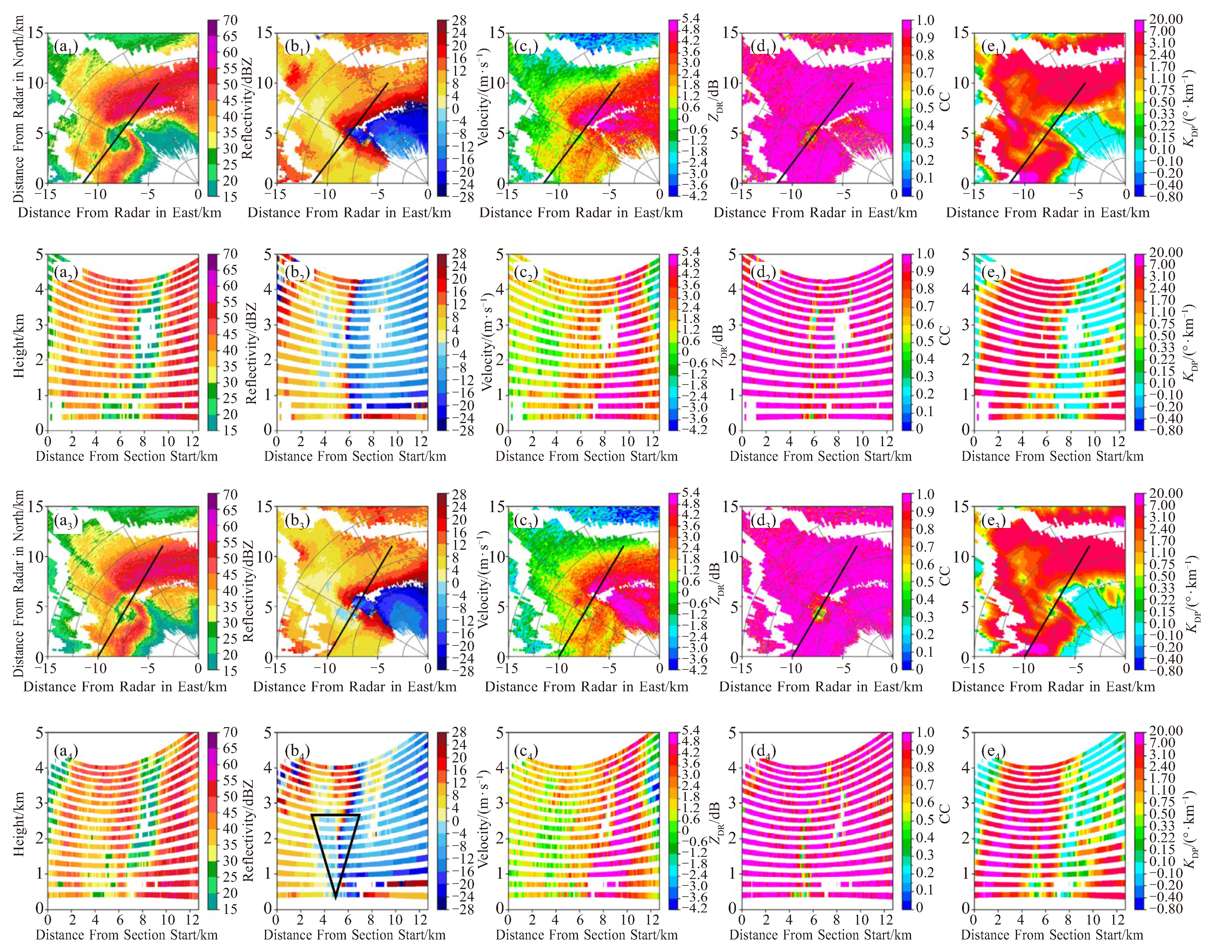
图 9 13:48、14:18、14:48、14:54广州CINRAD/SAD双偏振雷达0.5° 40 dBz等值线及径向速度V(a1、a2、a3、a4)、对应时间的反射率因子(b1、b2、b3、b4)、图a中沿黑色实线径向速度V的垂直剖面(c1、c2、c3、c4)、差分反射率ZDR(d1、d2、d3、d4)、相关系数CC(e1、e2、e3、e4)和差分传播相移率KDP(f1、f2、f3、f4)垂直剖面

图 10 帽峰山XPAR雷达-0.9°反射率因子(a1~a4: dBZ)、径向速度(b1~b4: V)、差分反射率因子(c1~c4: ZDR)、相关系数(d1~d4: CC)、差分传播相移率(e1~e4: KDP)及剖面
a2, b2, c2, d2, e2为a1, b1, c1, d1, e1中黑实线垂直剖面,时间为14:48;a4, b4, c4, d4, e4为a3, b3, c3, d3, e3中黑实线垂直剖面,时间为14:49。
表 1 4月27日08时探空与订正探空环境参数
环境参数 CAPE/(J·kg-1) LCL/M K/℃ T85/℃ SHR1/(m·s-1) SHR3/(m·s-1) SHR6/(m·s-1) SRH/(m2·s-2) EHI 4.27T08 476.3 297.8 38.1 24.9 7.2 17.9 24.5 176.7 0.3 4.27T12 4 072.2 417.1 9.1* 28.4* 24.6* 145.8* 7.02* 4.27T13 3 674.0 379.8 8.5* 14.7* 21.9* 144.1* 2.81* 4.27T14 3 571.0 277.2 25.5* 21.4* 25.1* -76.9* 1.76* 注:*代表使用花都风廓线雷达数据与花都国家基本气象站10 m高度2 min平均风矢量计算得出。  下载: 导出CSV
-
[1] 朱皓清. 2016年阜宁龙卷超级单体风暴及龙卷的数值模拟研究[D]. 南京: 南京信息工程大学, 2021. [2] 张桂莲, 李一平, 江靖, 等. 多个超级单体风暴诱发的EF3级强龙卷特征分析[J]. 气象, 2023, 49(11): 1315-1327. [3] 植江玲, 黄先香, 顾伯辉, 等. 广东两次超级单体导致不同类型强风天气对比分析[J]. 气象, 2022, 48(7): 813-825. [4] 黄先香, 炎利军, 顾伯辉, 等. 广东一次超级单体强龙卷的形成环境和观测特征分析[J]. 热带气象学报, 2021, 37(5): 721-732. [5] 王仕奇. 江淮地区一次超级单体龙卷风数值模拟与形成机制研究[D]. 南京: 南京信息工程大学, 2023. [6] 郑媛媛, 朱红芳, 方翔, 等. 强龙卷超级单体风暴特征分析与预警研究[J]. 高原气象, 2009, 28(3): 617-625. [7] 王福侠, 俞小鼎, 闫雪瑾. 一次超级单体分裂过程的雷达回波特征分析[J]. 气象学报, 2014, 72(1): 152-167. [8] 龚佃利, 朱君鉴, 林曲凤, 等. 一次超级单体引发的秋季特大冰雹和龙卷雷达探测分析[J]. 气象, 2024, 50(5): 561-576. [9] 陈瑞敏, 赵孝伟, 于海磊, 等. 一次长生命史超级单体风暴的雷达观测特征[J]. 暴雨灾害, 2021, 40(4): 419-429. [10] 俞小鼎, 王秀明, 李万莉, 等. 雷暴与强对流临近预报[M]. 北京: 气象出版社, 2020. [11] 俞小鼎, 姚秀萍, 熊廷南, 等. 多普勒天气雷达原理与业务应用[M]. 北京: 气象出版社, 2006. [12] Wurman J, Kosiba K, White T, et al. Supercell tornadoes are much stronger and wider than damage-based ratings indicate[J]. Proceedings of the National Academy of Sciences of the United States of America, 2021, 118(14): e2021535118. [13] 郑永光. 中国龙卷气候特征和环境条件研究进展综述[J]. 气象科技进展, 2020, 10(6): 69-75. [14] 郑永光, 朱文剑, 姚聃, 等. 风速等级标准与2016年6月23日阜宁龙卷强度估计[J]. 气象, 2016, 42(11): 1289-1303. [15] 郑永光, 蓝渝, 曹艳察, 等. 2019年7月3日辽宁开原EF4级强龙卷形成条件、演变特征和机理[J]. 气象, 2020, 46(5): 589-602. [16] 黄先香, 炎利军, 王硕甫, 等. 佛山市龙卷风活动的特征及环流背景分析[J]. 广东气象, 2014, 36(3): 20-24. [17] 植江玲, 白兰强, 黄先香, 等. 2022年6月19日广东佛山龙卷的双极化相控阵雷达特征[J]. 热带气象学报, 2024, 40(2): 297-312. [18] Zhang Y, Bai L Q, Meng Z Y, et al. Rapid-scan and polarimetric phased-array radar observations of a tornado in the Pearl River Estuary[J]. Journal of Tropical Meteorology, 2020, 26(3): 81-86. [19] 张培昌, 朱君鉴, 魏鸣. 《龙卷形成原理与天气雷达探测》[M]. 北京: 气象出版社, 2019. [20] 王秀明, 俞小鼎. 热带一次致灾龙卷形成物理过程研究[J]. 气象学报, 2019, 77(3): 387-404. [21] 袁潮, 李得勤, 杨磊, 等. 冷涡背景下一次微型超级单体龙卷的雷达特征和物理过程探究[J]. 气象学报, 2022, 80(6): 878-895. [22] Byko Z, Markowski P, Richardson Y, et al. Descending reflectivity cores in supercell thunderstorms observed by mobile radars and in a high-resolution numerical simulation[J]. Weather and Forecasting, 2009, 24(1): 155-186. [23] Rasmussen E N, Straka J M, Gilmore M S, et al. A preliminary survey of rear-flank descending reflectivity cores in supercell storms[J]. Weather and Forecasting, 2006, 21(6): 923-938. [24] Meng Z Y, Yao D. Damage survey, radar, and environment analyses on the first-ever documented tornado in Beijing during the heavy rainfall event of 21 July 2012[J]. Weather and Forecasting, 2014, 29(3): 702-724. [25] 吴彬. 灾害性对流天气的双偏振多普勒雷达监测与机理研究[D]. 南京: 南京信息工程大学, 2023. [26] Trapp R J, Stumpf G J, Manross K L. A reassessment of the percentage of tornadic mesocyclones[J]. Weather and Forecasting, 2005, 20(4): 680-687. [27] 郑永光, 刘菲凡, 张恒进. 中国龙卷研究进展[J]. 气象, 2021, 47(11): 1319-1335. [28] Zhao K, Wang M J, Xue M, et al. Doppler radar analysis of a tornadic miniature supercell during the landfall of typhoon Mujigae (2015) in South China[J]. Bulletin of the American Meteorological Society, 2017, 98(9): 1821-1831. [29] Kennedy A, Straka J M, Rasmussen E N. A statistical study of the association of DRCs with supercells and tornadoes[J]. Weather and Forecasting, 2007, 22(6): 1191-1199. [30] Brown R A, Lemon L R, Burgess D W. Tornado detection by pulsed Doppler radar[J]. Monthly Weather Review, 1978, 106(1): 29-38. [31] Ryzhkov A V, Schuur T J, Burgess D W, et al. Polarimetric tornado detection[J]. Journal of Applied Meteorology, 2005, 44(5): 557-570. [32] Kumjian M R, Ryzhkov A V. Polarimetric signatures in supercell thunderstorms[J]. Journal of Applied Meteorology and Climatology, 2008, 47(7): 1940-1961. [33] 黄先香, 炎利军, 白兰强, 等. 广东龙卷时空分布及其母体风暴雷达观测特征[J]. 气象, 2024, 50(7): 804-817. [34] Bai L Q, Yao D, Meng Z Y, et al. Influence of irregular coastlines on a tornadic mesovortex in the Pearl River Delta during the monsoon season. part I: pre-storm environment and storm evolution[J]. Advances in Atmospheric Sciences, 2024, 41(6): 1115-1131. [35] Curtis L. Midlevel dry intrusions as a factor in tornado outbreaks associated with landfalling tropical cyclones from the Atlantic and gulf of Mexico[J]. Weather and Forecasting, 2004, 19(2): 411-427. [36] Wen J Y, Meng Z Y, Bai L Q, et al. A comparison between the only two documented tornado outbreak events in China: tropical cyclone versus extratropical cyclone environments[J]. Weather and Forecasting, 2024, 39(4): 613-638. [37] 俞小鼎, 赵娟, 范雯杰. 中国龙卷的时空分布与关键环境参数特征[J]. 热带气象学报, 2021, 37(5): 681-692. [38] Brooks H E, Lee J W, Craven J P. The spatial distribution of severe thunderstorm and tornado environments from global reanalysis data[J]. Atmospheric Research, 2003, 67-68: 73-94. [39] 郑媛媛, 张备, 王啸华, 等. 台风龙卷的环境背景和雷达回波结构分析[J]. 气象, 2015, 41(8): 942-952. [40] Sandmæl T N, Smith B R, Reinhart A E, et al. The tornado probability algorithm: a probabilistic machine learning tornadic circulation detection algorithm[J]. Weather and Forecasting, 2023, 38(3): 445-466. [41] 郑媛媛, 朱红芳, 方翔, 等. 强龙卷超级单体风暴特征分析与预警研究[J]. 高原气象, 2009, 28(3): 617-625. [42] 黄俊杰, 苟阿宁. 鄂西北一次超级单体风暴过程的观测分析[J]. 暴雨灾害, 2018, 37(5): 462-469. [43] Moller A R, Doswell C A Ⅲ, Foster M P, et al. The operational recognition of supercell thunderstorm environments and storm structures[J]. Weather and Forecasting, 1994, 9(3): 327-347. [44] Markowski P M. Hook echoes and rear-flank downdrafts: a review[J]. Monthly Weather Review, 2002, 130(4): 852-876. [45] Markowski P M, Richardson Y P. Tornadogenesis: our current understanding, forecasting considerations, and questions to guide future research[J]. Atmospheric Research, 2009, 93(1-3): 3-10. [46] Hubbert J, Bringi V N, Carey L D, et al. CSU-CHILL polarimetric radar measurements from a severe hail storm in eastern Colorado[J]. Journal of Applied Meteorology, 1998, 37(8): 749-775. [47] Wakimoto R M, Bringi V N. Dual-polarization observations of microbursts associated with intense convection: the 20 July storm during the MIST project[J]. Monthly Weather Review, 1988, 116(8): 1521-1539. [48] Hall M P M, Goddard J W F, Cherry S M. Identification of hydrometeors and other targets by dual-polarization radar[J]. Radio Science, 1984, 19(1): 132-140. [49] Herzegh P H, Jameson A R. Observing precipitation through dual-polarization radar measurements[J]. Bulletin of the American Meteorological Society, 1992, 73(9): 1365-1374. [50] Sachidananda M, Zrnić D S. Rain rate estimates from differential polarization measurements[J]. Journal of Atmospheric and Oceanic Technology, 1987, 4(4): 588-598. [51] Aydin K, Seliga T A, Balaji V. Remote sensing of hail with a dual linear polarization radar[J]. Journal of Climate and Applied Meteorology, 1986, 25(10): 1475-1484. [52] Balakrishnan N, Zrnic D S. Use of polarization to characterize precipitation and discriminate large hail[J]. Journal of the Atmospheric Sciences, 1990, 47(13): 1525-1540. [53] 刘红亚, 杨引明, 张晶, 等. 一次冰雹天气的WSR-88D双偏振雷达特征分析[J]. 气象与环境科学, 2020, 43(2): 1-10. -

 点击查看大图
计量
- 文章访问数: 2
- HTML全文浏览量: 1
- PDF下载量: 0
- 被引次数: 0
 粤公网安备 4401069904700003号